![]()
Prev Page--Contents || Next Page--Geography
Introduction
Purpose of the Investigation
In the Ladder Creek drainage basin in Kansas, in the Smoky Hill River basin above Cedar Bluff reservoir, there is heavy pumping of ground water for irrigation, and probably the use of ground water for that purpose will increase greatly in the future. This investigation was made to further the understanding of the quantity and quality of the available ground water.
The data upon which this report is based were collected at the request of the United States Bureau of Reclamation as a part of the Interior Department program in the Missouri Basin.
Location and Extent of the Area
The area discussed in this report includes the Kansas part of the Ladder Creek drainage basin and those parts of northeastern Scott County and northwestern Lane County that lie directly east of the Ladder Creek drainage. This eastern section has been included in the report because it is physiographically, geologically, and hydrologically similar to the Ladder Creek drainage basin and because some ground water is used for irrigation in this eastern section.
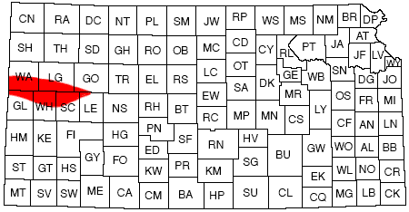
The approximate boundaries of the area are: on the north, Smoky Hill River and its South Fork; on the east, the line between R. 28 W. and R. 29 W.; on the south, the ground-water divide between the Arkansas and Smoky Hill River basins, which runs approximately through Shields, Healy, Manning, Scott City, and Leoti, and then slightly north of west to a point on the Kansas-Colorado line about 5 miles south of the Wallace-Greeley County line; and on the west, the Kansas-Colorado line (Fig. 1). The area investigated includes approximately 1,930 square miles.
Figure 1--Map of Kansas showing area covered by this report and areas that have been covered under cooperative ground-water program and under Missouri Basin program of the Department of Interior.
Previous Investigations
Several studies concerning the geology and ground water of parts of the area have been published. In 1897, Haworth discussed the physiography of western Kansas and the physical properties of the Tertiary deposits in western Kansas. The 1895 and 1896 Report of the Board of Irrigation Survey and Experiment (Haworth, 1897a) summarized the possibilities of irrigation in western Kansas, described experiments with windmills and gasoline-driven pumps, and discussed the geology of ground water in western Kansas in some detail. Darton (1905) reported on the geology and ground water in much of the Great Plains area including western Kansas. Haworth (1913) included a brief chapter on water in the Tertiary of western Kansas in which he summarized the principal references pertaining to ground water and discussed the occurrence of ground water generally. Elias (1931) described the Ogallala formation, the principal water-bearing formation in the Ladder Creek area, and the Pierre shale and Niobrara formation of Cretaceous age.
The geology and ground-water resources of Scott and Lane Counties were described by Waite (1947) and Prescott (1951), respectively. Prescott, Branch, and Wilson (1954) described the geology and ground-water resources of Wichita and Greeley Counties. These reports have maps showing water-table contours, depth to water, and saturated thickness of the water-bearing materials, and they contain water-level measurements and logs of test holes and wells. Irrigation-well development and fluctuations of the water levels are discussed.
Methods of Investigation
Field work for the investigation on which this report is based was begun in March 1951. An inventory of existing irrigation wells and of some domestic and stock wells was made to determine the configuration of the water table. Water levels in representative wells were measured periodically to determine water-table fluctuations.
Test holes were drilled by W. T. Connor and N. W. Biegler using the hydraulic-rotary drilling machine of the State Geological Survey of Kansas. The test holes were drilled to determine the thickness and character of the water-bearing materials and the configuration of the surface of the Cretaceous rocks that represent the base of the ground-water reservoir. Also, some test holes were jetted in the Smoky Hill River valley to determine the thickness and character of the alluvium.
The discharges of Ladder Creek and Smoky Hill River were measured during this study, by use of a pygmy current meter and standard measurement procedure. When runoff consisted principally of effluent seepage, the discharges at eight sites on Ladder Creek and three sites on Smoky Hill River were measured periodically. The discharge at other sites also was measured occasionally. Observation wells were installed near the gaging sites to study the relation between local water-table fluctuations and stream discharge.
To determine the permeability and transmissibility of the water-bearing formations in the area, several aquifer tests were made by J. J. Schmidt on irrigation wells. The methods used in computing the results of the tests are discussed in the section on ground water.
The geologic map was prepared by mapping the area south of Smoky Hill River in Wallace and Logan Counties and southwestern Gove County and combining the resulting map with the maps of Lane, Scott, Wichita, and Greeley Counties that had previously been made as a part of the cooperative ground-water program in Kansas. K. L. Parish mapped the geology of most of Logan County, and N. W. Biegler mapped the geology of most of Wallace County. Biegler and Parish collaborated on the rest of those counties and southwestern Gove County. Altitudes of wells, of several points along Ladder Creek, and of some rock exposures were determined by C. K. Bayne and W. W. Wilson, using an alidade.
As a part of the ground-water investigation in the Ladder Creek area, quality of the water from selected wells and from streams was studied. Water samples for chemical-quality studies were obtained in Wallace, Logan, Greeley, Wichita, and Scott Counties in September 1951. In all, 36 samples from wells and 8 samples from surface sources were obtained. The analyses were made by C. J. Zabel of the U. S. Geological Survey.
Acknowledgments
The writers wish to express their appreciation to many persons who contributed information for this report. Special thanks are due Weishaar & Son and Ben Hasz of Scott City, who provided well logs. Residents in the area cooperated in giving information regarding their wells.
The writers are grateful also to personnel of the United States Bureau of Reclamation for their cooperation and assistance in the study. Ed Kramer, H. R. McDonald, Marion Ball, and R. E. Glover were consulted frequently during the course of the investigation.
Well-Numbering System
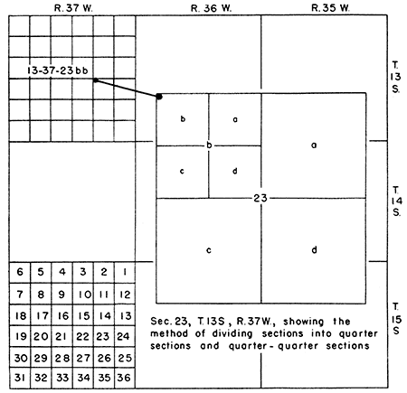
The well numbers used in this report show the location of each well according to General Land Office surveys of the area. These numbers are assigned in accordance with the following formula: township, range, section, quarter section, and 40-acre tract within the quarter section. When two or more wells are within a 40-acre tract, the wells are numbered serially according to the order in which they were inventoried. The quarter section and 4O-acre tracts are designated a, b, c, and d in a counterclockwise direction, beginning in the northeast quarter (Fig. 2).
Figure 2--Sketch illustrating well-numbering system used in this report.
Prev Page--Contents || Next Page--Geography
Kansas Geological Survey, Geology
Placed on web Jan. 29, 2013; originally published December 1957.
Comments to webadmin@kgs.ku.edu
The URL for this page is http://www.kgs.ku.edu/Publications/Bulletins/126/02_intro.html