![]()
Prev Page--Stratigraphy--Devonian || Next Page--Stratigraphy--Pennsylvanian
Stratigraphy, continued
Rocks of Mississippian Age
Mississippian rocks are widely distributed in the Mississippi Valley both at the surface and in the subsurface. Some of the formations were deposited only in certain regions, and the areal extent of others was restricted by erosion. As a result the sequence of Mississippian formations in Kansas is nowhere complete and in different localities formations are missing from the top, middle, or bottom of the columnar section. Some of the breaks in the formational sequence are true disconformities, but some were accompanied by obscure warping of so Iowan order that angular unconformity can be determined only by regional studies of the distribution and thickness of single formations and their relations to underlying and overlying units.
Limestone and dolomite predominate in the Mississippian rocks of the Middle West. The Mississippian of Kansas consists entirely of limestone and dolomite, except for the Northview shale, a local facies of the lower Sedalia dolomite in southeastern Kansas, and some shaly beds in the st. Joe of south-central Kansas. The Boice shale in the northeastern corner of Kansas may be of Mississippian age. Shale partings of negligible thickness have been reported between limestone beds in some formations.
The Mississippian formations represented in the Salina basin are listed in Table 5 in descending order.
Table 5--Mississippian formations represented in the Salina basin
| Meramecian Series | ||
| Spergen limestone | ||
| "Warsaw" limestone | ||
| Unconformity | ||
| Osagian Series | ||
| Burlington and Keokuk limestones, undifferentiated | ||
| Upper zone | ||
| Unconformity | ||
| Lower zone | ||
| Reeds Spring limestone | ||
| St. Joe limestone | ||
| Unconformity | ||
| Kinderhookian Series | ||
| Gilmore City limestone | ||
| Unconformity | ||
| Sedalia limestone (upper member only) | ||
| Unconformity | ||
| Rocks of Devonian or Mississippian age | ||
| Boice shale | ||
| Unconformity | ||
| Chattanooga shale | ||
Kinderhookian Series
The Chouteau limestone was first described by Swallow (1855) at Chouteau Springs, Cooper County, Missouri. The outcrops nearest to the Salina basin are in Pettis County in north-central Missouri. At the outcrops and in the subsurface of northeastern Kansas, three units of the Chouteau limestone, as originally defined, are distinguished by lithologic criteria: (1) a basal unit of relatively pure semigranular limestone, which is essentially equivalent to the Compton limestone of outcrops in southwestern Missouri; (2) a middle unit, an impure sucrose gray to buff dolomite having large amounts of uniquely characteristic chert; and (3) an upper unit, a noncherty or sparsely cherty buff sucrose dolomite. In Miami, Linn, and Anderson counties in eastern Kansas the middle unit grades southward into, and is at least a partial correlative of the Northview silty shale of southwestern Missouri and southeastern Kansas (Lee, 1940, p. 31).
In 1928 Moore separated the upper and middle units from the originally defined Chouteau and applied to them the name Sedalia limestone, and restricted the term Chouteau to the lower unit. The upper unit of the sequence in the subsurface was considered for a time as the Sedalia by the Missouri Geological Survey, and this usage was followed by Lee in 1940.
In 1943 Lee (p. 67) described the Chouteau of Moore and the upper and lower members of the Sedalia limestone in the Forest City basin as three members of Swallow's original Chouteau. In the present report these terms are used to conform with the usage of the Kansas Geological Survey-namely, the application of Sedalia limestone to the upper and middle units of the original Chouteau and the restriction of Chouteau to the lower unit.
The Chouteau of Moore (1928) and both members of the Sedalia are well developed in the Forest City basin (Lee, 1943, p. 67), but only the upper member of the Sedalia has been recognized west of the Nemaha anticline.
Sedalia Dolomite
The upper member of the Sedalia consists of buff to brown, locally gray, sucrose dolomite. It is generally noncherty, but in some wells small amounts (less than 5 percent) of chert similar to that in the lower member of the Sedalia have been noted in the insoluble residues. The upper member of the Sedalia extends westward to Smith County and southward across Saline County. Thin outliers occur south of Saline County as shown in Figure 12A.
Unconformities occur above and below the upper member in the Salina basin, but its more or less uniform thickness reveals that both its upper and lower surfaces were locally exceptionally smooth and regular. The upper member thins westward with extraordinary regularity from Johnson County, Kansas, where it is 30 feet thick and overlies the lower member of the Sedalia, to Smith County, 200 miles west, where it is less than 10 feet thick and overlies pre-Chattanooga rocks. In the Salina basin it is less than 15 feet thick except in a few wells, and in some of the outliers in McPherson and Harvey counties it is represented by less than 5 feet of buff sucrose dolomite.
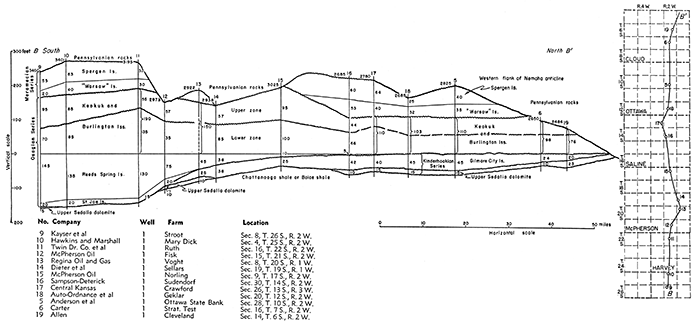
Figure 13--Cross section B-B' from Sedgwick County north to Cloud County on line of inset, Plate 6, and Figure 12, showing southerly thinning of Kinderhookian limestones and overlap and thinning of Osagian and Meramecian formations toward the north. [Larger version available as an Acrobat PDF file.]
The upper member of the Sedalia seems to be conformable upon the lower member in the Forest City basin. In the Salina basin, however, it overlaps uncomformably upon the Chattanooga shale or the Boice shale where that formation is present, and wedges out to the west on the Devonian.
In the Salina basin the upper member of the Sedalia is nearly everywhere overlain disconformably by the Gilmore City limestone. The dis conformity is obscure, but it is revealed in several wells in the Forest City basin in which the upper member of the Sedalia is missing and the Gilmore City rests on the lower member of the Sedalia (Lee, 1943, p. 69). In McPherson and Marion counties the Gilmore City rests on the Chattanooga shale where the upper member of the Sedalia is absent. In these counties some of the thin outliers of upper Sedalia dolomite are overlain by the St. Joe limestone, and locally in Reno County, the Reeds Spring limestone overlaps upon the upper Sedalia (Fig. 12B and cross section B-B' of Fig. 13).
Gilmore City Limestone
The Gilmore City was first described by Laudon (1933) at outcrops in the vicinity of Gilmore City in central Iowa. At the outcrops the Gilmore City is mainly pure white to gray oolitic limestone. Laudon reports that it is "usually bedded with green shale" and that minor amounts of blue dolomite occur at definite horizons. The Gilmore City limestone in the subsurface, distribution of which in the Salina basin is shown in Figure 12A, is similar to that of the outcrops, but it is not oolitic throughout and is not dolomitic. It is 62 feet thick in the Seidhoff et al No. 1 Greif well in sec. 16, T. 8 S., R. 10 W., but may be thicker toward the north. Its thickness decreases somewhat irregularly toward the southeast; it wedges out in southern McPherson County and parts of Harvey County.
The Gilmore City in the Salina basin is a relatively pure noncherty or very slightly cherty granular limestone composed of worn fragments of finely broken fossils, with or without oolites, embedded in a cryptocrystalline matrix. The matrix is firm in samples from some zones but so chalky in others that except for the fossiliferous granules the cuttings from cable tool wells are generally reduced to calcareous mud and lost in washing. The oolitic limestone is generally gray or white, but shades of dark gray, yellowish brown, and buff are not uncommon, and in one well the color is pink. Fragments of green argillaceous shale are minor constituents of some samples.
The most outstanding characteristic of the Gilmore City limestone is the oolitic limestone. The oolites are irregularly distributed vertically, and the oolitic beds are discontinued horizontally. Oolites are commonly encountered 25 to 35 feet above the base of the Gilmore City, but oolitic beds occur erratically higher and lower in the formation. The oolites are of various sizes and some of them are irregular in shape. Most are gray but some are dark, nearly black. Some of the oolites have black centers and some have alternating light and dark crusts. The oolites generally have the same color as the matrix.
The insoluble residues of the Gilmore City are so small in amount as to be almost negligible. Chert particles derived from younger rocks in the wells occur in the insoluble residues of some samples, but there are also traces of indigenous vitreous chert. The characteristic residues consist of loose aggregates of very fine quartz crystals and thin finely drusy crusts and microscopic mammillary and columnar Hakes of chalcedony. Traces of spherical crusts from partly silicified oolites are occasionally found. Residues from wells in Saline County and northward are generally' pale lemon yellow, but elsewhere they are colorless.
Where the Gilmore City is thin and not oolitic it is distinguished from the St. Joe by the darker color and argillaceous character of the St. Joe. Although the lower part of the Reeds Spring in some areas is a semi granular limestone not unlike the Gilmore City, the Reeds Spring contains translucent chert, but the Gilmore City does not.
At places along its southern margin, the Gilmore City rests unconformably on Chattanooga shale or on outliers of the upper member of the Sedalia dolomite. The Gilmore City is separated by a pronounced unconformity from the overlying Osagian rocks. In a few wells in Harvey County, as in the McBride Inc. No. 1 Friesen well in sec. 20, T. 22 S., R. 3 W., in northwestern Harvey County, a thin bed of nonoolitic Gilmore City limestone is overlain by dull dark earthy St. Joe limestone, which elsewhere overlies the upper member of the Sedalia or the Chattanooga shale. Farther north the Gilmore City is overlain by the Reeds Spring dolomite, and still farther north by the lower zone of the Burlington-Keokuk limestone sequence (Fig. 12A, 12B).
Osagian Series
Osagian rocks are widely distributed in the Mississippi Valley and are represented in the subsurface in the Salina basin. As originally used by Williams (1891), the term Osage included only the Burlington and Keokuk limestones of southeastern Iowa. The term was later expanded to include the underlying Fern Glen limestone of eastern Missouri. Some geologists include the overlying Warsaw limestone in the Osagian, but on account of the pronounced unconformity at the base of the southern Kansas "Warsaw" the writer places it in the Meramecian.
The Fern Glen is represented in southwestern Missouri by the Reeds Spring limestone above and the St. Joe limestone below, both of which change their lithologic character in the subsurface toward the west. In outcrops in southwestern Missouri and in the subsurface of southeastern Kansas the St. Joe limestone consists of noncherty or very sparsely cherty semi granular fossiliferous limestone. Toward the west, in southern Kansas, the St. Joe thickens and some zones become argillaceous. In the area south of the Salina basin it includes beds of calcareous green and red shale and some reddish granular limestone.
At outcrops in southwestern Missouri the Reeds Spring consists of dolomite interbedded with vitreous dark to almost black chert, opaque in hand specimens but semitranslucent in small chips. In the subsurface of southeastern Kansas the chert cuttings from wells are dark to brownish and semitranslucent. Farther west in southern Kansas the dolomite changes gradually to semigranular limestone containing various amounts of semitranslucent to translucent bluish-gray and colorless chalcedonic chert. The correlatives of both the St. Joe and Reeds Spring thin and wedge out toward the north, both east and west of the Nemaha anticline. Neither is present on the crest of the anticline (Fig. 12B). The Reeds Spring limestone overlaps northward beyond the margin of the St. Joe, and in turn it is overlapped by the more widely distributed Burlington.
St. Joe Limestone
In the area just south of the Salina basin, in Sedgwick County, the St. Joe limestone is 75 to 100 feet thick and consists of interlayered beds of noncherty semigranular limestone, argillaceous limestone, and calcareous shale. Toward the north this sequence of beds becomes thinner and more argillaceous and on the southern border of Harvey County consists of dark argillaceous limestone, in part earthy textured and in part dark, impure, dull, and finely crystalline. In Harvey County the St. Joe ranges in thickness from 10 to 40 feet. It thins out irregularly northward in the basin that lies between the Central Kansas uplift and the Nemaha anticline, as shown on Figure 12B. The variation in thickness is due chiefly to the unconformity at its base. The distinction between St. Joe and Reeds Spring in most parts of southeastern Kansas is based on the absence of chert in the St. Joe cuttings and presence of chert in the Reeds Spring cuttings. Consequently, the separation is arbitrary and the selected contact somewhat variable in position. In Harvey County the argillaceous character and the dark color of the St. Joe provide additional criteria for their differentiation.
In different localities in Reno and Harvey counties the St. Joe is in contact with the underlying Gilmore City, the upper member of the Sedalia, or the Chattanooga shale, on all of which it is unconformable. Thus, in the McBride No. 1 Friesen well in sec. 20, T .. 22 S., R. 3 W., 5 feet of dark dense St. Joe limestone overlies 25 feet of Gilmore City; in the Boyle Grossman Drilling Company No. 1 Moulds well in sec. 7, T. 24 S., R. 1 W., 25 feet of St. Joe limestone overlies 5 feet of upper Sedalia dolomite; in the Garland et al No. 1 Cox well, in sec. 27, T. 24 S., R. 1 W., 30 feet of St. Joe overlies Chattanooga shale. The contact between St. Joe and Reeds Spring limestones is transitional in southeastern Kansas. In the Salina basin, it seems to be conformable, although in Harvey County a marked lithologic break at the top of the dark earthy limestone of the St. Joe commonly marks the contact with the Reeds Spring.
Reeds Spring Limestone
In the part of Kansas south of the Salina basin the Reeds Spring limestone, of late Fern Glen age, is composed mainly of semigranular limestone, but it includes some interbedded dolomite and some slightly argillaceous limestone. Chert is conspicuous throughout most of the formation; at some places, however, zones near the base are only sparsely cherty. The distinguishing feature of the Reeds Spring is the translucent and semitranslucent character of the chert. The color of the chert is variable. Shades of blue and bluish gray predominate. Some zones are yellowish and some are dark and brown, like the chert in the outcrops in southwestern Missouri and northeastern Oklahoma. Some of the chert is colorless in thin chips. In drill cuttings the chert is generally represented by smooth splinters and blocky fragments with sharp flinty edges. In some zones minor amounts of opaque blocky chert with rough surfaces accompany the semitranslucent chert. The contact of the Reeds Spring with the Burlington is determined by the change from the dominantly semitranslucent splintery chert of the Reeds Spring to the dominantly opaque and semiopaque blocky chert of the Burlington.
The distribution of the Reeds Spring in the Salina basin is shown in Figure 12 B. In this basin the Reeds Spring overlaps the St. Joe limestone and thins to a wedge toward the north, east, and west. It is thickest on the southern margin of the mapped area (Fig. 12 B) in northern Sedgwick County and southern Harvey County, where it is 100 to 120 feet thick. In the area where it overlaps beyond the St. Joe limestone its thickness is materially reduced. In central McPherson County its thickness ranges from 30 to 60 feet, but in central Saline County its thickness in very few places exceeds 20 feet (Fig. 13). Its presence north of Saline County is doubtful.
The Reeds Spring is conformable above the St. Joe limestone, but in the absence of the St. Joe it is unconformable on the older rocks upon which it overlaps. It overlies the Chattanooga shale in parts of Reno County and in much of Butler County. It overlies thin outliers of the upper member of the Sedalia at a few places in Reno County, but toward the north, in the absence of the St. Joe, the Reeds Spring overlaps upon the Gilmore City.
The contact of the Reeds Spring with the overlying lower zone of the Burlington-Keokuk sequence is transitional. The lack of a clear-cut lithologic contact between them, and the irregularity of the eroded surface at the base of the Reeds Spring where it overlaps beyond the St. Joe account for some of the variations in its thickness.
Burlington and Keokuk Limestones
Burlington and Keokuk limestones are widely distributed in the Mississippi Valley both at the surface and in the subsurface, but without the aid of fossils their differentiation in the subsurface of the Salina basin is unsatisfactory. Moore (1928, p. 143, 207) and Moore, Fowler, and Lyden (1939, p. 9) reported a hiatus between the Burlington and the Keokuk in outcrops in southwestern Missouri. In the Joplin district Moore found the Burlington limestone absent and the Keokuk lying disconformably on the Reeds Spring limestone. Laudon (1939, p. 329) reports the same relations throughout northeastern Oklahoma. Lee (1940, p. 58) has described lithologic differences between the lower and upper zones of the Burlington-Keokuk sequence in the subsurface of Kansas and tentatively correlated the zones, respectively, with the Burlington limestone and the Keokuk limestone. The variable position of the contact between the two lithologic zones supports the conclusion that the upper zone lies unconformably on the lower. Where the Burlington is absent in the Joplin area, only rocks of the upper zone are present. In other areas both lithologic phases occur with erratic variations in thickness. The lower zone, which is transitional with the underlying Reeds Spring, is at least partly of Burlington age and the upper zone at least partly of Keokuk age. Both zones consist of cherty limestone and dolomite but they are differentiated by the character of the chert.
Lower zone of the Burlington-Keokuk sequence--The lower zone is characterized by opaque chert of microscopically dense texture, which appears in well cuttings as blocky fragments with more or less tabular surfaces. The sequence of beds characterized by typical white opaque chert is interrupted in some wells by zones rarely more than 5 feet thick containing semitranslucent chert of the Reeds Spring type. A minor amount of rough nondescript chert is present in many samples; some chert, commonly associated with sucrose dolomite or dolomitic limestone, shows a grainy or stippled pattern on the smoothly broken surface; some of the chert breaks with rough and pitted surfaces. Traces of sparsely distributed micro-organisms and spicules appear on the broken faces of some chert fragments in the upper part of the lower zone. Insoluble residues of samples from the lower zone reveal quartz crystals, drusy quartz, and hackly quartz. Insoluble residues from some dolomitic beds include dolomoldic chert.
The lower zone varies in thickness from place to place by reason of its unconformable relation to the upper zone and its locally obscure contact with the Reeds Spring. It is thickest in Harvey County, where several wells penetrated more than 150 feet. It is 155 feet thick in the Rosenthal and Madison No. 1 Masters well in sec. 24, T. 23 S., R. 3 W., but farther north it is commonly 75 to 120 feet thick, although locally it is thinner. In areas where it overlaps beyond the Reeds Spring its thickness is commonly less than 50 feet.
Upper zone of the Burlington-Keokuk sequence--Most of the chert of the upper zone is white, rough, and pitted, and breaks to subangular fragments. Although other types of chert occur in the upper part of the zone, they are uncommon in the lower part. Microfossiliferous chert similar to that in the "Warsaw" occurs in some areas in the middle or upper part of the upper' zone, but it is distinguished from "Warsaw" chert by the replacement of the micro-organisms with glassy or translucent chalcedony. The cherts of the upper zone include various amounts of siliceous aggregates resembling tripoli, which are sometimes referred to as "cotton rock". Some of the "cotton rock" is firm but some is soft. The greater part of the limestone and dolomite of the lower zone is siliceous and when treated with acid yields soft tripolitic crumbs of "cotton rock" that constitute a considerable proportion of the volume of the insoluble residues. Insoluble residues of dolomitic beds contain also dolomoldic chert. The contact between limestone with blocky opaque gray chert of the lower zone and limestone with subangular, rough, pitted, and tripolitic white chert of the upper zone is generally sharply marked.
In southeastern Kansas, where the Burlington limestone is absent, an oolitic bed (probably the Short Creek oolite) occurs high above the base of the Keokuk limestone. On the southern margin of the Salina basin, where the upper zone of the Keokuk-Burlington sequence is underlain by the lower zone, the oolitic bed lies at or near the base of the upper zone. The oolitic bed was not observed in the more northerly wells in the Salina basin.
The upper zone, which is bounded both above and below by disconformities, varies greatly in thickness. In Harvey County and northern Butler County its thickness is as much as 110 feet locally, although thicknesses of 70 to 80 feet are more common. It is less than 70 feet thick in most areas north of Harvey County and is absent in some wells on the margin of the Salina basin, where it was removed by pre-Pennsylvanian erosion. In general, the upper zone, like the lower zone, is thinner toward the north than toward the south, and their combined thickness where they are overlain by the "Warsaw" is also less.
The upper zone is separated by unconformity from the overlying Meramecian formations. In the Salina basin the upper surface of the upper zone was one of moderate relief, but farther south, near the Oklahoma border, the Keokuk and older rocks were deeply eroded.
Meramecian Series
Rocks of Meramecian age are present in widely separated areas in the Mississippi Valley. In Kansas they consist in descending order of the Ste. Genevieve, St. Louis, Spergen, and "Warsaw" limestones* and the Cowley formation. The sequence from the "Warsaw" limestone to the Ste. Genevieve limestone occurs in the subsurface of the deeper parts of the Forest City basin and on the southwestern flank of the Central Kansas uplift in western Kansas. The "Warsaw" and Spergen limestones are preserved in the central part of the Salina basin and in other synclinal areas. All the formations of Meramecian age except the Cowley were probably deposited throughout Kansas but were removed from anticlinal areas by the erosion that followed the post-Mississippian deformation.
[* Note: Rocks called Warsaw by Lee in the manuscript of this report are judged to be wholly younger than the type Warsaw, which carries a characteristic Osagian fauna and, as confirmed by recent field studies of Laudon, must be classed as upper Osagian--not lower Meramecian. Accordingly, Lee's Warsaw has been changed editorially to "Warsaw",-R. C. Moore, (Footnote, Lee, 1948)]Meramecian time was preceded by an elevation of Kansas above sea level, as a result of which the Keokuk and earlier Mississippian rocks were deeply eroded in southern Kansas, where in some valley areas erosion cut through the Chattanooga shale and exposed pre-Chattanooga rocks. The relations of the early Meramecian deposits to the Keokuk in the Salina basin reveal a dissected surface at the base of the Meramecian, although the relief is less pronounced than in southern Kansas. The first deposit of Meramecian age in southern Kansas during the resubmergence of the region was the Cowley formation (Lee, 1940, p. 66-78). In areas near the shore line on the northern margin of the eroded basin, this formation consists of silty and dolomitic gray and black shale, but basinward, in southern Kansas and northern Oklahoma, it becomes less argillaceous and more dolomitic. The Cowley is commonly very cherty, although the chert content differs greatly in different areas. The chert is characterized by crowded masses of micro-organisms, but this characteristic is less well developed in northern Oklahoma. As the advancing sea spread out over the less deeply eroded surface of the upland toward the north, the argillaceous and silty Cowley sediments graded upward into the "Warsaw" semigranular limestone. The Spergen limestone overlies the "Warsaw" with seeming conformity in eastern Kansas and is followed by St. Louis and Ste. Genevieve limestones. Neither of the latter formations has been recognized in the Salina basin. It is probable that they were formerly deposited but were removed by pre-Pennsylvanian erosion.
"Warsaw" Limestone
The "Warsaw" limestone in the Salina basin consists mainly of semigranular cherty limestone, although some sucrose dolomite occurs as the matrix cementing crystalline fragments of broken fossils, The chert is variable in amount but rarely constitutes as much as 40 percent of the volume of samples. It is typically lighter colored than the chert of the. Cowley formation, and although the silicified organic remains are revealed in dark patterns against a gray matrix in some fragments, much of the microfossiliferous chert is entirely. gray and the microfossiliferous character is less noticeable. The silicified fossils of the "Warsaw" chert are commonly coarser than those in the Cowley.
The maximum observed thickness of 80 feet of "Warsaw" is in the Kinney-Coastal Oil Company No. 1 Beil well in sec. 23, T. 14 S., R. 5 W. This thickness is exceptional. The "Warsaw" is commonly less than 50 feet thick, and it wedges out locally on the flanks of topographically high areas of the pre-"Warsaw" surface as shown between wells 15 and 16 of Figure 13. The great differences in thickness are due to the unconformities at the top and bottom. The oldest beds of the "Warsaw" seem to have been deposited in deeply eroded areas of the Keokuk surface, and the later beds of the "Warsaw" seem to have overlapped on higher parts of this surface.
The "Warsaw" limestone and the overlying Spergen limestone survived post-Mississippian erosion only in the deeper parts of the Salina basin, They are present in the syncline between the Voshell anticline and the Central Kansas uplift, in synclinal areas east and west of the Halstead and Graber pools, and in the structural basin west of the Valley Center anticline (Fig, 12B). On the flanks of these synclines, the "Warsaw" was beveled by pre-Pennsylvanian erosion and covered by Pennsylvanian rocks.
Spergen Limestone
The Spergen limestone is less widely distributed than the "Warsaw" in the structural basins and synclinal areas of the Salina basin. It is composed mainly of noncherty yellowish granular limestone with a slightly waxy luster. In some localities the limestone is interstratified in the upper part with noncherty sucrose dolomite. Patient examination of the granular limestones generally reveals the presence of thinly disseminated specimens of the foraminifer Endothyra. Insoluble residues of the dolomitic beds reveal much silt and "spongy" masses of sponge spicules. The basal member is generally dolomitic and silty. In wells in T. 20 and 21 S., R. 4 W., the basal dolomite is 15 to 20 feet thick and includes exceptionally large amounts of semitranslucent chalcedonic chert, which in this area amounts to 10 to 20 percent of the samples. This dolomitic member is of variable thickness and is less silty and less cherty farther north.
The Spergen is less than 40 feet thick in most wells in which it has been encountered. In the Auto Ordnance-Darby No. 1 Gawith well in sec. 27, T. 11 S., R. 5 W" a thickness of 99 feet was drilled (well 5, cross section A-A', Pl. 6), and in the absence of lithographic limestone by which the St. Louis limestone is commonly recognized, the entire thickness of this unusually thick limestone is referred somewhat doubtfully to the Spergen.
The Spergen normally succeeds the "Warsaw" but where the "Warsaw" is absent it may overlap upon the Keokuk. In the Salina basin surviving remnants of the Spergen are everywhere unconformable beneath rocks of Pennsylvanian age.
Prev Page--Stratigraphy--Devonian || Next Page--Stratigraphy--Pennsylvanian
Kansas Geological Survey, Geology
Placed on web Jan. 5, 2017; originally published Dec. 1956.
Comments to webadmin@kgs.ku.edu
The URL for this page is http://www.kgs.ku.edu/Publications/Bulletins/121/03_strat4.html