![]()
Prev Page--Stratigraphy--Ordovician to Silurian || Next Page--Stratigraphy--Mississippian
Stratigraphy, continued
Rocks of Devonian Age
The outcrops of Devonian rocks nearest to the Salina Basin are situated in central Missouri, where Devonian formations of no great thickness appear at the surface in separated outcrops. Branson (1944, p. 131, 151) recognized and named the formations of Middle Devonian age in northern Missouri, each of which is bounded by disconformities. These formations, in ascending order, are Cooper limestone, Ashland limestone, and Callaway limestone. The Upper Devonian is represented by the Snyder Creek shale, which lies disconformably on the Callaway in outcrops but is not represented in northeastern Kansas. The Cooper limestone of the outcrops consists mainly of bluish-gray lithographic limestone. It is nearly everywhere characterized by basal beds of sandstone, calcareous sand, or sandy limestone.
Rocks of Cooper age, consisting of lithographic and sublithographic limestone, have been traced in the subsurface westward from the outcrops into northeastern Kansas. West of the Nemaha anticline, from the crest of which the Devonian rocks were later eroded, the Devonian has been identified by its basal sandy beds as far west as T. 6 S., R. 1 W. West of this point the basal sandy beds have not been recognized except in a thin outlier in T. 5 S., R. 10 and 11 W. The Devonian rocks of the Salina basin area are divided conveniently into upper and lower zones by a bed of cherty or siliceous dolomite at the top of the lower zone. The formations above the Cooper limestone have not been differentiated in the subsurface.
The lower zone of the Devonian rocks includes a sandy bed at the base and in most areas a cherty bed at the top. In the central part of the North Kansas basin the lower zone consists of dolomite of sucrose texture. In many areas nearer the margin of the basin the dolomite is interstratified with limestone, but in Harvey County and adjoining areas south of the pre-Chattanooga valley the Devonian consists of grainy, finely crystalline dolomite capped by cherty dolomite. Insoluble residues reveal that the grainy character of the dolomite in this area is due to the presence of very fine subrounded to subangular sand. Embedded medium-grained sand typical of the Devonian in other wells of the area identify this dolomite as Devonian. In the Phil-Han Oil Company No. 1 Currie well in sec. 10, T. 15 S., R. 1 W., the lower 40 feet of the lower zone consists of semigranular limestone interbedded with thin sheets of sucrose dolomite. The sandy bed at the base of the lower zone is generally dolomitic but in a few wells toward the southern margin of the North Kansas basin the sandy bed is a limestone. The embedded sand grains are of medium size, and mainly rounded and frosted. They constitute a trace to 40 percent of the volume of the sample. In some wells sand is thinly disseminated throughout most of the lower zone. In the Scow Bros. et al No. 1 Gates well, in sec. 16, T. 9 S., R. 4 E., 20 feet of dolomitic sandstone containing some green clay shale directly underlies the cherty bed. Considerable sand, as much as 20 percent of the samples, occurs in a bed 40 to 60 feet above the base of the Devonian in the McLaughlin No. 1 Allen well in sec. 32, T. 8 S., R. 16 E., and various amounts of sand also are found several feet above the basal sandy bed in some other wells.
The cherty dolomite at the top of the lower zone is 10 to 35 feet thick, and the chert content in the insoluble residues ranges from 10 to 80 percent of the samples. Part of the chert is gray and opaque and its texture is massive to grainy and spicular. Part is white and soft and resembles tripoli. The thickness of the lower zone ranges from 105 feet in the Ohio Oil Company No. 1 Lamparter well in sec. 3, T. 2 S., R. 14 E., to 30 feet or less on the southern margin of the North Kansas basin, where the Devonian rocks were beveled by pre-Chattanooga erosion.
The increase in thickness of the lower zone toward the center of the North Kansas basin seems to be the result of the differential subsidence of the basin during the deposition of the lower zone of the Devonian.
The upper zone consists of the Devonian rocks above the persistent white chert beds. It was reduced to its present thickness by post-Devonian erosion. It is 100 feet thick and lies at a depth of 2,185 to 2,285 feet in the Gulf No. 1 Baker well in sec. 1, T. 1 S., R. 2 E. It is 55 feet thick and lies at a depth of 1,650 to 1,705 feet in the Davon No. 1 Schaefer well in sec. 20, T. 1 S., R. 6 E., but it is only 10 feet thick and at a depth of 2,237 to 2,247 feet in the Phillips· No. 1 Helms well in sec. 20, T. 4 S., R. 2 E. The upper zone is absent farther south as a result of post-Devonian erosion. In the Gulf-Baker well the upper zone is composed of limestone interbedded with dolomite and in the Davon-Schaefer well it consists of red, brown, and gray limestone. Elsewhere it is composed of various types of dolomite, but in some wells the dolomite is interstratified with thin limestone beds. The upper zone provides no useful datum beds, and except locally it is doubtful whether the persistent white chert bed at the top of the lower zone is a reliable datum, on account of the variation in its thickness.
Most of the Devonian rocks, whether limestone or dolomite, are dense. Even on the eroded pre-Chattanooga surface they do not ordinarily develop porosity. Where the original texture of the exposed rocks is favorable, however, porosity has developed, as in the upper 40 feet of the Devonian in the Arkansas Fuel Company No. 1 Martin well in sec. 24, T. 8 S., R. 4 E.
Porosity occurs also in a local sandstone directly below the cherty dolomite beds in the Scow Bros. No. 1 Gates well in sec. 16, T. 9 S., R. 4 E., and in the sandy slightly dolomitic member near the base of the Devonian dolomite in the same well. Porosity occurs also in many wells where the basal beds consist of very sandy dolomite or a dolomitic sand as in the Leeward Petroleum Corporation No. 1 Knight well in sec. 23, T. 13 S., R. 3 E.
The Devonian dolomite and limestone in eastern Kansas, in the area of the map, have a maximum thickness of 213 feet in the Ohio Oil Company No. 1 Lamparter well in sec. 3, T. 2 S., R. 14 E. They are considerably thicker in southeastern Nebraska and become irregularly thinner toward the southern margin of the North Kansas basin. They are 75 feet thick in the Veeder Supply and Development Company No. 1 Gravenstine well in sec. 21, T. 8 S., R. 6 E., but were cut out by erosion of a pre-Chattanooga valley in Marion and McPherson counties. In the Devonian area in Harvey County, south of the valley, the Devonian rocks range in thickness from a maximum of 83 feet in the McPherson Oil Company No. 1 Ruth well in sec. 14, T. 23 S., R. 2 W., to a featheredge on the eroded margin still farther south.
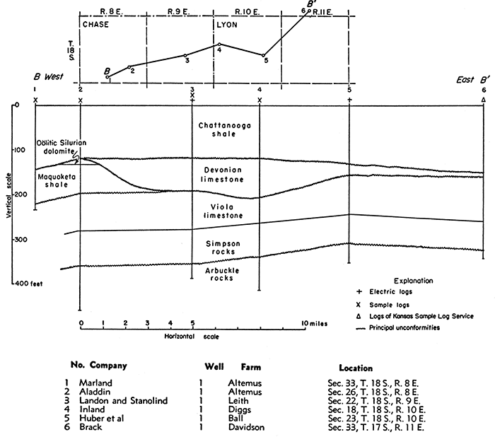
After the deposition of the Silurian rocks the region was raised above sea level during active development of the Chautauqua arch. Erosion reduced the surface to a rolling plain of moderate topographic relief that truncated the tilted Silurian and older formations. Closely spaced wells in southeastern Ottawa County and northwestern Dickinson County reveal pre-Devonian hills of Silurian dolomite no longer covered by Devonian rocks. Cross section C-G' of Figure 9 (cross section C-C' of Pl. 3) across two of these hills shows topographic relief exceeding 50 feet. In northeastern Chase County and west-central Lyon County a relatively narrow valley about 50 feet deep was eroded along the pre-Devonian outcrop of the Maquoketa shale, as shown in cross section B-B' of Figure 10 and the line B-B' of Plate 3. This valley narrows the outcrop of the Maquoketa shale on the pre-Devonian areal map and is indicated on Plate 3 by the great thickness of the Devonian. The upper surface of the Devonian was more nearly peneplained than the pre-Devonian surface except in Marion and McPherson counties, where a broad deep valley was eroded before the deposition of the Chattanooga shale.
Figure 9--Cross section C-C', in Saline and Dickinson counties, on inset and on Plate 3, showing pre-Devonian hills of Silurian dolomite reexposed by pre-Chattanooga erosion. [Larger version available as an Acrobat PDF file.]
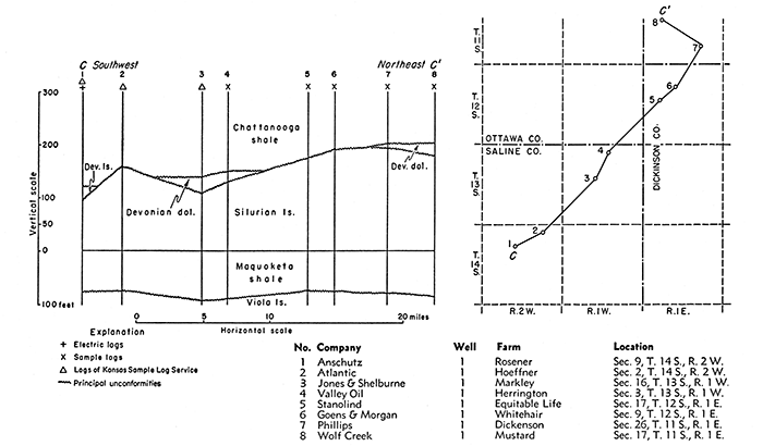
Figure 10--Cross section from east to west across pre-Devonian valley in Chase and Lyon counties, along line B-B' on inset and Plates 2 and 3.
Disregarding the extremes of thickness caused by local hills on the pre-Devonian surface and the removal of the Devonian by erosion in the pre-Chattanooga valley, it is evident that the Devonian limestones progressively overlie the previously beveled surface of older rocks from.the center toward the margin of the North Kansas basin on the flank of the Chautauqua arch. The Devonian overlies 398 feet of Silurian in the Davon No. 1 Schaefer well in sec. 20, T. 1 S., R. 6 E., 315 feet of Silurian in the Arkansas Fuel Company No. 1 Martin well in sec. 24, T. 8 S., R. 4 E., 290 feet in the Payrock No. 1 Johnson well in sec. 9, T. 12 S., R. 6 E., and 150 feet in the Youker No. 1 Larsen well in sec. 16, T. 16 S., R. 3 E., just north of the pre-Chattanooga valley in Marion County. The Devonian originally overlapped from the Silurian onto the Maquoketa, but the line of overlap was in the main cut out by the erosion of the pre-Chattanooga valley.
South of the valley the Devonian rests on the eroded surface of the Maquoketa in such wells as the Panhandle Eastern Pipe Line Company No. 1 Waltner well in sec. 36, T. 21 S., R. 3 W., where 75 feet of Maquoketa intervene between the Devonian and the Viola. In the Tidewater No. 1 Heyman well in sec. 33, T. 23 S., R. 5 E., and in nearby wells, the Devonian rests on 35 feet of coarsely crystalline dolomite of the lower part of the Viola. In the Phillips No. 1 Guilfoyle well in sec. 18, T. 25 S., R. 8 E., the Devonian overlaps upon the Simpson. East of the area of the map, the Devonian in some localities overlies the Arbuckle.
Although the surface of the Silurian was roughly truncated by pre-Devonian erosion, considerable relief survived the erosional processes in certain areas. The most conspicuous relief is manifest in southeastern Ottawa County and adjoining parts of Dickinson County. In sec. 15, T. 11 S., R. 1 W., Chattanooga shale overlies 160 feet of Silurian rocks, but in sec. 28, T. 10 S., R. 2 W., 6 miles distant, 50 feet of sandy Devonian dolomite overlies only 100 feet of Silurian. In sec. 20, T. 12 S., R. 2 W., 12 feet of sandy dolomite caps 158 feet of Silurian, but in a well in sec. 16, T. 13 S., R. 1 W., 8 miles distant, Devonian rocks overlie only 109 feet of Silurian. Samples from a well in sec. 19, T. 13 S., R. 3 W., reveal 57 feet of Devonian sandy limestone overlying only 80 feet of Silurian. Inasmuch as other wells in this township penetrated 100 to 137 feet of Silurian capped by Chattanooga shale, the Silurian must have been thicker in Devonian time than now. Similar evidence indicates pre-Devonian topographic relief in the eastern part of T. 14 S., R. 2 W., and in adjacent areas.
Devonian rocks are not represented in the samples from the Page and Gurley No. 1 Bonham well in sec. 31, T. 1 N., R. 1 E., in Nebraska just north of the Kansas border, where some thickness of Devonian might have been anticipated, but no samples are available for 200 feet above the Silurian.
A sequence 58 feet thick tentatively identified as Devonian rocks because of traces of fine sandstone at the base has been reported from the Wakefield No. 1 Stockton well in sec. 26, T. 2 S., R. 15 W. The fine sand at the base of the sequence in this well more clearly resembles the coarse silt in the disconformable Maquoketa shale in a nearby well in sec. 5, T. 3 S., R. 11 W., than the sand residues usual at the base of the Devonian. This and the fact that oolitic dolomite is present 20 feet above the base of the sequence makes it more reasonable to refer these rocks to the Maquoketa than to the Devonian.
Plate 3 shows the thickness of the Devonian rocks and the pre-Chattanooga areal geology. Inliers of thick Silurian rocks in parts of Ottawa, Dickinson, and Saline counties reveal pre-Devonian eminences from which the Devonian cover was removed by pre-Chattanooga erosion. The pre-Chattanooga valley is indicated by outcrops of Silurian, Maquoketa, and Viola on the valley slopes.
It is interesting to note that aside from the channel (Fig. 10) following the Maquoketa outcrop in Chase and Lyon counties, the Devonian is thickest in a belt closely paralleling and just east of the Nemaha anticline. Although fewer wells are available, the data seem to indicate a belt of thin Devonian rocks farther east. The structural relations revealed by wells in this area suggest a syncline and an anticline and give support to the concept that the stresses that ultimately produced the Nemaha anticline were already causing deformation at the end of Devonian time.
Distribution of Devonian rocks--There is some difference of opinion as to the position of the base of the Devonian or even as to the presence of the Devonian west of T. 6 S., R. 1 W., and north of the pre-Chattanooga valley in McPherson County. In this area basal sandy rocks are absent in the "Hunton" in most wells. The "Hunton" sequence in this area consists of very cherty and argillaceous limestone and dolomite, which are regarded by some geologists as of Devonian age. Their relation to the Devonian seems to be revealed by comparison of two wells in Cloud County; the Bells-Wells No. 1 Le Blanc well in sec. 35, T. 6 S., R. 1 W., and the Stanolind Oil Company No. 1 Campbell well in sec. 26, T. 6 S., R. 2 W., only 6 miles distant.
The Devonian in the Le Blanc well in T. 6 S., R. 1. W., consists of 60 feet of lithographic and sublithographic gray limestone overlying 170 feet of Silurian. Embedded medium and coarse sand grains are disseminated throughout most of the sequence and are more abundant toward the base, where the samples include calcareous sandstone. Insoluble residues of the lithographic and sublithographic limestones yield no chert or flocculent or other siliceous residues except the sand.
The corresponding zone in the Campbell well 6 miles distant is also 60 feet thick, but consists of varicolored mealy or chalky or semigranular limestone accompanied by 5 to 65 percent massive varicolored subopaque to semitranslucent vitreous chert. The residues from the limestone include flocculent silica and traces of dusty quartz particles but no sand or silt.
The contrast in the lithology of these beds does not in itself preclude essential continuity, for abrupt lateral transition in relatively short distance is not unknown. However, the "Hunton" rocks in all the wells for which samples are available in the area west of T. 6 S., R. 1 W., and northwest of McPherson County display chert similar to that in the Campbell well. No embedded sand grains have been observed in any of the "Hunton" rocks in this area except in T. 5 S., R. 10 and 11 W., where sandy limestone occurs above the varicolored vitreous chert, and in the following outliers: (1) in sec. 26, T. 8 S., R. 10 W., where 12 feet of Devonian sandy limestone overlies Maquoketa shale, (2) in sec. 29, T. 15 S., R. 6 W., where 5 feet of sandy limestone overlies 20 feet of Silurian oolitic dolomite, (3) in sec. 4, T. 16 S., R. 4 W., where 18 feet of sandy Devonian dolomite overlies Maquoketa shale, and (4) in sec. 20, T. 19 S., R. 2 W., where 8 feet of sandy dolomite overlies 16 feet of Silurian oolitic dolomite shown in well 9 of cross section A-A' of Plate 3. On the other hand, sandy dolomite or sandy limestone occurs at the base of the Devonian in nearly all the wells east of R. 1 W.
Toward the south the Silurian consists almost entirely of vuggy, medium to coarsely crystalline dolomite almost devoid of chert, but many wells toward the center of the North Kansas basin include considerable amounts of chert in the Silurian. The nearest of these wells is the Phillips No. 1 Helms well in sec. 20, T. 4 S., R. 2 W., in which cherty beds were first penetrated at a depth of 2,410 feet, 112 feet below the Devonian and 195 feet above the base of the Silurian. These cherts are in part semiopaque bluish-gray and buff-gray vitreous chert similar to the more strikingly varicolored vitreous chert in the Campbell well and occur at about the same interval above the base of the Silurian. Similar cream-color, gray, and bluish-gray vitreous chert occurs also in the Silurian in the Gulf No. 1 Baker well in sec. 1, T. 1 S., R. 2 E., at a depth of 2,331 to 2,360 feet. No chert of this type has been observed anywhere in authentic Devonian rocks. In the Phillips No. 1 Helms and other wells the Devonian cherts are white, opaque, and in part spicular, microfossiliferous, and grainy. Such cherts do not occur in the Campbell well and have not been recognized west of T. 6 S., R. 2 W.
The writer believes that the discrepancy in lithology between beds to the east of R. 1 W., represented by the lithology of the Devonian in the Le Blanc well, and beds to the west characterized by the cherts of the Campbell well, believed to be Silurian, is the result of topographic relief of the pre-Devonian surface. The surface west of T. 6 S., R. 1 W., seems to have remained too high to receive the earliest Devonian deposits except as noted in T. 5 S., R. 10 and 11 W. It is probable that these areas were eventually submerged in the Devonian sea, but that the Devonian rocks in these areas were removed by pre-Chattanooga erosion except locally where Devonian rocks survived as outliers. This conclusion is supported by the abundant evidence of topographic relief at the contact of the Silurian and Devonian rocks in nearby areas already cited.
Rocks of Devonian or Mississippian Age
Chattanooga Shale
In eastern Kansas a sequence of black and gray shales of undetermined age separates limestones definitely of Mississipian age from limestones and dolomites definitely of Devonian age. A black shale in southwestern Missouri, earlier called Eureka shale and Noel shale, was correlated with the Chattanooga shale by Adams and Ulrich (1905), and was subsequently correlated with the Grassy Creek shale of northeastern Missouri by Branson (1944, p. 159). The Chattanooga shale thickens to the north and west from the outcrops in southwestern Missouri.
Johnston (1934, p. 15), in describing the stratigraphy of the Hollow pool of Harvey County, Kansas, described this shale sequence between the "Mississippi limestone" and the top of the "Silurian-Devonian group" as interrupted by Chouteau limestone, and for this reason he placed the upper part of the shale in the Kinderhookian Series. These correlations are based upon the discovery of Kinderhookian fossils in a dolomite core* taken from the McBride No.4 Abraham Schmidt well in the NE cor. NE sec. 30, T. 22 S., R. 3 W., Harvey County. It seems probable, however, that the fossiliferous material was not in place when cored, that the dolomite of the sample represents rocks knocked from the base of the Mississippian limestone above the shale when the casing was run, and that, after cementation, it was this material at the bottom of the hole below the pipe that was cored. This conclusion is based on the following considerations: (1) the presence of cavings below the cement is revealed by the fact that the first cuttings below the cement include fragments of opaque white chert of the BurlingtonKeokuk type not known in the Kinderhookian, and also traces of the Kinderhookian Gilmore City oolitic limestone commonly found in wells in this area directly above the Sedalia and above the Chattanooga; (2) dolomite lithologically identical with the fossiliferous cores overlies the shale sequence in other parts of Harvey County and in McPherson County (Fig. 12A); (3) dolomite of this character has not been found within the shale sequence in Harvey and adjoining counties, where many clean samples from wells drilled by cable tools have been examined; (4) the occurrence of Kinderhookian dolomite within the shale sequence is incompatible with the regional relations and distribution of the Kinderhookian rocks as described in a subsequent section of this report.
[* Note: The core was taken below 78 feet of shale and above 7 or 8 feet of black shale crowded with spores typical of the basal Chattanooga. Casing in this well was set and cemented at 3,431 feet, 71 feet below the top of the shale. The sample from a depth 01 3,436 feet, taken after the casing was cemented, consisted entirely of cement and a few fragments of dark shale. A cored sample was taken between the depths of 3.438 and 3,442 feet. The sample representing the first 2 feet consisted of fossiliferous dolomite Interlaminated with dense limestone. The sample representing the second 2 feet, not seen by the writer, is described as sand and sandy shale reported as "Misener sand". Drill cuttings below 3,442 feet consist of black shale containing spores typical of the basal Chattanooga above the Misener. Devonian limestone was encountered at 3,449 or 3,450 feet. The fossiliferous dolomite core from 3,438 to 3,440 feet, lent by Sinclair Prairie Oil Company, was examined in 1946 by L. R. Laudon and R. C. Moore of the Kansas Geological Survey, who agree on the Kinderhookian age of the embedded fossils.]
The use of the term "Kinderhook shale" for Chattanooga shale has become standard usage among oil geologists, however inappropriate, but, like the term "Nemaha mountains" or "Nemaha granite ridge" for Nemaha anticline, is, unfortunately, not likely to be discarded.
At the outcrops in southwestern Missouri and in the subsurface of adjacent parts of Kansas, the Chattanooga shale ranges in thickness from a featheredge to 30 feet and consists of black fissile shale, slightly silty and finely micaceous, containing conspicuous amounts of pyrite. North and northwest of the outcrops the formation becomes much thicker and is lighter in color except the basal beds, which are generally dark or black. In northeastern Kansas the color of the shale is generally gray or gray green, but in some places the upper beds are interstratified with darker shale. In the Salina basin the shale is finely micaceous, less silty and more argillaceous than to the south and east. The basal darker shales generally include abundant spores, but spores are embedded only sparingly throughout the upper beds of the Chattanooga.
With increasing thickness the Chattanooga becomes in part dolomitic locally and in some areas includes beds of impure sucrose dolomite. In the Appleman No. 1 McManus well in sec. 29, T. 15 S., R. 6 W., spores occur in impure silty dolomite 50 feet below the top and 35 feet above the base of the Chattanooga. Spores are embedded in sucrose dolomite in the Globe No. 1 Ostlind well in sec. 8, T. 19 S., R. 3 W., at a depth of 3,438 feet, 50 feet below the top of the Chattanooga, and in many other wells in thin beds of dolomite as well as in the shale.
The Misener sand at the base of the Chattanooga shale is of erratic distribution. In the central part of the Salina basin, it is generally represented only by rounded sand grains disseminated in shale at the base of the Chattanooga. Where the Misener is a sandstone, it includes many rounded grains like those in the Simpson sandstone, from which it was probably derived. It lies below the black spore-bearing shale. In the Hollow pool in T. 22 S., R. 3 W., Harvey County, cores from below the Misener sand reveal a bed, 1 or more feet thick, of gray or black slate containing numerous specimens of Lingula.
The thickness of the Misener sand is greatest in wells in the deeper parts of the pre-Chattanooga valleys, where the Chattanooga shale is thick, and on the flanks of the Central Kansas uplift. The development of the sandstone facies, although by no means general, seems to bear a relation to the proximity of pre-Chattanooga outcrops of Simpson sandstone on the Central Kansas uplift and to pre-Chattanooga outcrops of the basal sandy beds of the Devonian.
In many wells in Marion, McPherson, Saline, and Harvey counties, the Misener forms a bed of sandstone less than 2 feet thick in most places but in some localities much thicker. In Rice County several wells have penetrated 10 to more than 35 feet of Misener sand. It is 11 feet thick in a well in sec. 24, T. 11 S., R. 7 W., Lincoln County, and 5 feet thick in a well in sec. 35, T. 8 S., R. 9 W., Mitchell County.
In many wells north of Dickinson County and in some wells as far south as Marion County red or pink beds lie above the Chattanooga shale. They are interpreted in part as remnants of a weathered zone developed during the exposure that preceded the deposition of the Boice shale and in part as weathered material reworked to form the basal deposits of the Boice shale.
The thickness of the Chattanooga ranges from a featheredge to at least 263 feet. This considerable variation results from the unconformity at the base of the Chattanooga and from the several periods of exposure of the top during which the original thickness of the Chattanooga was reduced by erosion.
In Edwards and Pawnee counties, where Maquoketa, Silurian, and Devonian rocks are absent southwest of the Central Kansas uplift, the rocks between the Mississippian and the Viola differ from the Chattanooga ("Kinderhook" of oil fields) shale in eastern Kansas areas. The rocks in these counties consist of greenish-gray and rusty-brown shale interstratified with sandy shale and streaks and beds of sandstone in the upper part as well as at the base. No black shale and no spores are reported. Dolomite, locally cherty, as much as 45 feet thick occurs in the middle of the formation in some wells on the flank of the Central Kansas uplift.
The lithology of these rocks is so strikingly different from the Chattanooga farther east as to suggest a Mississippian basal clastic deposit rather than Chattanooga. The cross section from Meade County to Smith County (Lee, 1953, fig. 2) shows that low arching of the Central Kansas uplift had already begun before Mississippian time. The formations normally deposited--Devonian, Silurian, Maquoketa, and part of the Viola--if they were ever present, were removed from this flanking area as well as from the crest. During the hiatus it seems probable that the exposed surface was dissected. Loose debris, sand, shale, and, in protected areas, dolomite might accumulate as a Mississippian basal clastic. Weathered Viola chert occurs at the base of this sequence in many wells, a phenomenon curiously rare or absent below the Misener sandstone. It is probable that these mixed clastics are a marginal facies of the Chattanooga or a local facies of the Boice shale to be described later.
In eastern and southeastern Kansas the thickness of the Chattanooga increases toward the north with some irregularity, but the local irregularities as represented by 50-foot isopachs are inconspicuous.
McPherson Valley--In McPherson and Marion counties, the pre-Chattanooga surface was dissected by a broad open valley having a topographic relief of more than 200 feet (Pl. 4). In T. 23 S., R. 2 W., south of the valley in Harvey County, on a pre-Chattanooga hill, the Chattanooga shale has a local thickness of less than 5 feet (well 3 of cross section A-A' of Pl. 4) and overlies Devonian limestone. From this area it thickens in all directions. In McPherson and Marion counties, in a distance of less than 25 miles, the thickness increases to more than 200 feet in the valley area, and the shale successively overlies increasingly older rocks from Devonian dolomite to Kimmswick dolomite. Farther north, the Chattanooga becomes thinner again and overlaps upon the same formations in reverse order. Both stratigraphic and structural relations indicate the development of a deep pre-Chattanooga valley, which may be called the McPherson Valley, the approximate configuration of which is shown by the thickness map of the Chattanooga shale (Pl. 4) and by the areal map of the pre-Chattanooga surface (Pl. 3). The pre-Chattanooga exposure of Silurian rocks in Lyon County (Pl. 3) suggests that the west-trending McPherson Valley headed in that county. A tributary entered the main valley from the south in western McPherson County (Lee, 1940, pl. 4). The river probably drained toward the north or northwest in an area in which it cannot now be traced because the original thickness of the Chattanooga was reduced by pre-Pennsylvanian erosion. The closure of the 250-foot isopach in the southwestern corner of Saline County is the result of the erosion of the original top of the Chattanooga and does not represent the topography of the pre-Chattanooga valley in that area.
Chattanooga limestone lentil--In parts of McPherson, Rice, and Reno counties, the Chattanooga deposits of the valley include a bed of limestone 100 to 110 feet below the base of the overlying Mississippian limestones. This limestone is gray and for the most part mealy or chalky and slightly argillaceous. It is capped in many wells by 5 to 10 feet of argillaceous sucrose dolomite. In some wells 5 to 10 feet of sublithographic limestone occurs at the base. Spores that are characteristic of the Chattanooga have been found not only in the dolomite capping the limestone but also in the upper part of the limestone in the Sharon No. 1 Leatherman well in sec. 35, T. 21 S., R. 9 W., as well as in the shale below and above the limestone. The thickness of the limestone ranges from a featheredge on the margin of the lentil to more than 80 feet in T. 21 S., R. 7 W.
The shaded area of Figure 11 shows the distribution and generalized thickness of the Chattanooga limestone and its relation to the pre-Chattanooga valleys. Except in T. 21 S., R. 7 and 8 W., where it is thin, the limestone is confined to the western side of the tributary that joins the McPherson Valley from the south. On the west the limestone overlaps upon the western slope of the valley as shown in cross section B-B', but the western margin of the valley was uptilted and beveled before Pennsylvanian time; therefore the original border of the limestone has been lost to erosion.
Figure 11--Areal distribution and cross sections of Chattanooga limestone lentil. A. Map showing thickness of Chattanooga limestone lentil. B. Cross section A-A' of map A. C. Cross section B-B' of map A. [Larger version available as an Acrobat PDF file.]
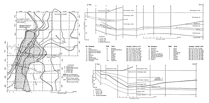
On the east the limestone is underlain by shale, which is 125 feet thick in well 5, cross section A-A' of Figure 11, but is commonly 50 to 60 feet thick. In cross section A-A' the shale is shown wedging out to the east. In cross section B-B' the limestone is shown interfingering with shale, but it may wedge out abruptly. The abruptness of the transition from limestone to shale is illustrated by two wells in sec. 34, T. 22 S., R. 8 W., for which both samples and electric logs are available. The shale in the well in the northeast corner of the section includes 25 feet of chalky limestone 105 feet below the top, but in the southwest corner of the same section, one mile distant, where the thickness of the Chattanooga is the same, neither samples nor electric logs reveal the presence of any limestone.
It might be expected that the Chattanooga limestone would be deposited in the deeper parts of the McPherson Valley where compaction of the shale might have provided a basin for marine invasion and the accumulation of limestone. Equally deep parts of the valley in other areas, however, were filled with shale without limestone. The peculiar isolation of this mid-Chattanooga limestone and its eccentric position mainly on the west side of the valley may, perhaps, be explained as the result of temporary shielding of the limestone area from clastic sediments by the building up of a shale delta at the mouth of the tributary to the McPherson Valley as the valleys were being filled.
The thickness of the Chattanooga shale as a whole ranges from a featheredge, in southeastern Kansas and in areas that have been uptilted and beveled, to more than 250 feet in the deep parts of the McPherson Valley and in the North Kansas basin in Nemaha County. The thickness displays considerable variation as a result of contemporaneous warping and the erosional unconformities at its base and top. The Chattanooga normally thickens toward the subsiding North Kansas basin. In northeastern Kansas, where the Chattanooga is thickest, it overlies limestone and dolomite of Devonian age. Toward the south in eastern Kansas it progressively transgresses upon the truncated outcrops of Silurian, Maquoketa, Viola, Simpson, and Arbuckle (pre-Chattanooga areal geology, Pl. 3). In central Kansas the regularity of its northward thickening is broken by the filling of the pre-Chattanooga valleys and the more irregular topography. Aside from the effect of the topographic relief of the McPherson Valley, the Chattanooga thickens northward toward the North Kansas basin.
After the deposition of the Chattanooga shale, the surface was re-elevated and was probably subjected to minor warping.
Near the Missouri-Nebraska line the normal sequence of Chattanooga shale in most wells is followed at different stratigraphic levels by gray-green shale interstratified with red and pink shale. In some wells the red shale includes concentrations of red oolites or fine ironstone pellets. These shale and ferruginous oolitic beds are not known to crop out anywhere at the surface. They are particularly well developed in the subsurface of southeastern Nebraska, where they were penetrated in many wells during the development of the Falls City oil field, but they occur also in adjoining parts of Missouri and Kansas and in southwestern Iowa. Reed (1946) proposed the name Boice shale for this formation.
Pre-Boice erosion of the Chattanooga shale is revealed in northeastern Kansas by the relations of the Chattanooga and Boice shales. In Nemaha and Brown counties, Kansas, where the combined thickness of the shales varies little, the Chattanooga thins where the Boice thickens and increases in thickness where the Boice is thin. The range in the thickness of the Chattanooga shale in this area from 120 to 258 feet is an imperfect indication of the topographic relief of the pre-Boice surface. Considerable areas to the west were probably stripped of Chattanooga shale at this time.
With resubmergence of the eroded surface, the higher areas of the Chattanooga shale were reduced by wave and tidal action, and the weathered and eroded material was washed into the low areas, which were aggraded to a common level with the beveled Chattanooga. The redeposited material constitutes the Boice shale.
The lower Kinderhook limestones, which normally succeed the Chattanooga shale in Missouri and northeastern Kansas, are missing west of the Nemaha anticline; the Gilmore City of late Kinderhookian age (Laudon, 1931) and possibly the upper beds of the Sedalia overlap upon pre-Chattanooga formations in parts of Smith, Osborne, and Jewell counties. The Chattanooga must have been eroded from these areas before the deposition of the Kinderhookian limestones, for in this area Gilmore City and upper Sedalia rocks, really of Kinderhookian age, overlap from the Chattanooga onto Devonian and older rocks. The exposure of this area may have begun before Boice time and extended through early Kinderhookian time.
The smooth horizontal contact of the Chattanooga shale with the Chouteau limestone and its correlatives throughout large areas in eastern Kansas, northern Missouri, and parts of Iowa gives the illusion of conformable relations between these formations. However, the fact that the Boice shale intervenes between the Chattanooga and the Chouteau in parts of the Forest City basin, and the fact that younger formations overlie the Chattanooga farther afield lead to the conclusion that a hiatus of some importance intervenes, although thinning of the Chattanooga in areas of overlap seems not to have been great.
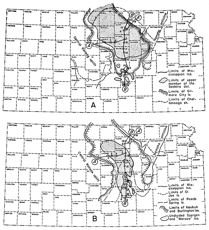
The final unconformity that modified the thickness of the Chattanooga developed in post-Mississippian time when the Nemaha anticline was raised and the Central Kansas uplift and the Ozarks were re-elevated. The erosion of these uplifted anticlinal areas removed the Mississippian limestones from their crests and beveled the Chattanooga and older rocks on their flanks, thus reducing the surface to what must have been essentially a peneplain. The Chattanooga shale cropped out on this surface in a belt encircling the area of older rocks (Pl. 4). South of McPherson County the Chattanooga is generally overlain by the St. Joe limestone of the Osagian Series, although there are some outliers of upper Sedalia and Gilmore City rocks. On the western flank of the Nemaha anticline and the eastern flank of the Central Kansas uplift, the Reeds Spring and the Burlington limestones overlap from St. Joe limestone upon Chattanooga shale (Fig. 12B).
Figure 12--Maps showing the approximate distribution of the Mississippian formations in the Salina basin area. A. Distribution of upper member of Sedalia limestone and Gilmore City limestone of Kinderhookian age. B. Distribution of St. Joe, Reeds Spring, and Burlington-Keokuk limestone sequence of Osagian age and Spergen-"Warsaw" limestone sequence of Meramecian age. Line A-A' shows trend of cross section A-A' of Plate 6. Line B-B' shows trend of cross section B-B' of Figure 13.
In consequence of the complex relations described, the Chattanooga rests unconformably on rocks ranging from Devonian to early Ordovician age and is overlain in certain areas by the Boice shale, by Mississippian limestones from the Chouteau to the Burlington, and by rocks of Pennsylvanian age. The unconformity above the Chattanooga shale is first recorded at its contact with the Boice shale. It is uncertain whether these unconformities express a prolonged hiatus with gradual overlap of younger formations upon the Chattanooga or a series of minor unconformities during which rocks deposited between Boice and Burlington time were successively removed in marginal areas during succeeding periods of exposure. The latter seems more likely.
Boice Shale
The Boice shale is best known from wells in southeastern Nebraska, where it was named by Reed ( 1946) for the Pawnee Royalty Company No. 1 Boice. well in sec. 18, T. 1 N., R. 16 E., Richardson County, Nebraska. A set of cable tool samples from this well is preserved in the files of the Nebraska Geological Survey. The section of the Boice shale as reported by Reed is given in Table 3.
Table 3--Section of Boice shale and Chattanooga shale in Pawnee Royalty Company No. 1 Boice cable tool well in sec. 18, T. 1 N., R. 16 E., Richardson County, Nebraska (Reed, 1946)
| Thickness, feet |
||||
|---|---|---|---|---|
| Mississippian System | ||||
| Kinderhookian Series | ||||
| Chouteau limestone and Sedalia dolomite | 69 | |||
| Boice shale | 31 | |||
| Siltstone and sandstone, medium dark gray to brownish, calcareous, in part pyritic | 2 | |||
| Shale, dark greenish gray with some pyritic and carbonaceous zones; calcareous with black "Sporangites" in lower 10 feet; interbedded with gray dolomitic siltstone and silty argillaceous dolomite | 19 | |||
| Hematite, in flattened discoidal oolites or concretions ranging from 0.2 mm to 1.5 mm in diameter, in part embedded in rouge-red shale | 10 | |||
| Mississippian or Devonian | ||||
| Chattanooga shale | 204 | |||
| Devonian dolomite | ||||
A section of rocks in Holt County, Missouri, here referred by the writer to the Boice shale (Table 4), was described by McQueen and Greene (1938, p. 176). At that time, the rocks were designated as "Kinderhook undifferentiated" by Mary Hundhausen of the Missouri Geological Survey.
Table 4--Section of Boice shale and Chattanooga shale in Forest City No. 1 Davis cored well in sec. 4, T. 59 N., R. 38 W., Holt County, Missouri
| Thickness, feet |
||
|---|---|---|
| Mississippian limestone and dolomite | 331 | |
| Boice shale | 43 1/2 | |
| Shale, gray to green; containing specks and streaks of carbonaceous material | 5 | |
| Dolomite, gray, argillaceous | 4 | |
| Shale, green and gray with plant remains | 24 | |
| Limonite, oolite, oolites are brown, flattened, and oblong | 4 | |
| Shale, gray and red | 2 1/2 | |
| Hematite oolite, flattened discoidal oolites cemented with calcium carbonate | 3 1/2 | |
| Hematite, dark red, shaly | 1/2 | |
| Mississippian or Devonian rocks | ||
| Chattanooga shale | 83 | |
The Boice shale consists of gray-green shale, in part carbonaceous, interbedded with gray dolomitic shale. The basal beds consist of oolitic limonite and hematite beds or red shale. Except where the Boice shale contains red and ferruginous oolitic beds, it is singularly like the Chattanooga shale from which the major part of the sediments of the Boice is believed to have been derived. In Nemaha and Brown counties, Kansas, where a considerable thickness of green and gray shale overlies the red oolitic beds, the Boice shale is finely micaceous, resembles the upper part of the Chattanooga, and includes thinly disseminated spores. The Boice shale is less silty and more dolomitic than the Chattanooga shale, but the lithologic differences are not sufficiently striking to distinguish the formations in the absence of the oolitic zone or the basal red beds.
The Boice shale so far as known is confined to southeastern Nebraska, southwestern Iowa, northwestern Missouri, and northeastern Kansas. In the Forest City basin in Kansas the Boice thins sharply southward from central Brown and Nemaha counties. Red shale at the top of the Chattanooga, probably in part of Boice age, occurs in northeastern Wabaunsee County. In the Salina basin ferruginous oolites extend south to Saline and Dickinson counties, and red shale without oolites to northeastern Marion County. Westward the oolitic bed extends to the border of the Central Kansas uplift, where in sec. 35, T. 8 S., R. 9 W., 25 feet of ferruginous oolitic beds overlie the Chattanooga, which is here represented only by 5 feet of sand of probable Misener age.
In Kansas, in the Ohio Oil Company No. 1 Lamparter well in sec. 3, T. 2 S., R. 14 E., the thickness of shale above the base of the hematite oolite at the base of the Boice is 90 feet, and the underlying Chattanooga shale is 135 feet thick. In sec. 15, T. 2 S., R. 16 E., the Boice shale is 110 feet thick, and the Chattanooga is 125 feet thick. In sec. 12, T. 4 S., R. 14 E., the Boice shale is only 14 feet thick, and the underlying Chattanooga is 258 feet thick. In scattered wells in Clay, Mitchell, Dickinson, and Saline counties the Boice shale, where present, is represented only by the red oolitic member, which is 5 to 25 feet thick. In these counties red shale without oolites, 20 to 40 feet thick, at the top of the shale sequence in some wells, may be of Boice age, but some of the zones of red shale, especially where they are mixed with green shale, may be weathered Chattanooga shale in place. A well in sec. 11, T. 13 S., R. 1 E., Dickinson County, where red and green shales 10 feet thick underlie the oolitic member of the Boice, is one sample of the second condition.
The Boice shale is unconformable on the Chattanooga and seemingly conformable below the Chouteau of Moore (1928) in the area centering around the corners of Nebraska, Kansas,' and Missouri. In the northern part of the Salina basin the oolitic bed, where present, is unconformably overlain by the upper member of the Sedalia dolomite. The Boice shale, although not specifically correlated with the Hannibal shale of Missouri, occupies the same stratigraphic position.
Prev Page--Stratigraphy--Ordovician to Silurian || Next Page--Stratigraphy--Mississippian
Kansas Geological Survey, Geology
Placed on web Jan. 5, 2017; originally published Dec. 1956.
Comments to webadmin@kgs.ku.edu
The URL for this page is http://www.kgs.ku.edu/Publications/Bulletins/121/03_strat3.html