![]()
Prev Page--Stratigraphy--Precambrian to Cambrian || Next Page--Stratigraphy--Devonian
Stratigraphy, continued
Rocks of Early Ordovician Age
Gasconade Dolomite
Insoluble residues characteristic of the Gasconade dolomite of Missouri are obtained from the cuttings of a few wells in eastern Kansas near the Missouri line. In wells 6 and 7 of the cross section (Fig. 3) both the coarsely dolomoldic chert distinctive of the lower Gasconade dolomite and the Gunter sandstone member at its base represented by sandy dolomite are well developed. Like the Eminence the Gasconade wedges out before it reaches the area under study. In well 7 the Gasconade overlies the Eminence as in McQueen's well 8 at Carthage, Missouri. In well 6 it unconformably overlaps upon the Bonneterre. It seems to be unrepresented in well 5, but the samples from this zone were reduced to dust in drilling and the evidence is inconclusive. If present it is thin. Insoluble residues characteristic of the Gasconade were not recognized in wells farther northwest, and this formation is probably missing in the Salina basin area.
In southern Missouri in well 12 of the cross section (Fig. 3) McQueen reports about 550 feet of Gasconade. In Kansas in well 7, the LaSalle No. 1 Gobl well in sec. 20, T. 28 S., R. 25 E., it is 215 feet thick, and in well 6, the No.3 Marian Smith well in sec. 10, T. 29 S., R. 15 E., it is 171 feet thick.
Roubidoux Formation
Nearly everywhere in Missouri the Roubidoux includes conspicuous beds of sandstone, which give the formation its distinctive character in outcrops. In Kansas, the sandstone beds are represented by sandy dolomite in which the embedded sand rarely exceeds 25 percent of the sample. The lower part of the formation is generally more sandy than the upper part. The chert that accompanies the sandy dolomite is varied and in part oolitic. The oolites occur in gray translucent chert and brown quartzose chert as well as in opaque chert. Some of the cherts are sandy, a feature that is characteristic of the Roubidoux. Tripolitic flakes are common in insoluble residues. The chert in many samples is roughly proportionate to the amount of sand.
As the areas of the Central Kansas uplift and the Salina basin are approached, the sand and chert content of the insoluble residues diminishes. In wells 1 and 2 of the cross section (Fig. 3) the insoluble residues are almost negligible. The presence of chert accompanying sand in the insoluble residues is somewhat arbitrarily regarded as distinguishing the Roubidoux from the underlying noncherty, otherwise somewhat similar Bonneterre dolomite, in wells in which the Bonneterre is not conspicuously glauconitic. In the absence of chert and absence of glauconite the contact has been placed arbitrarily where the white dolomite of the Roubidoux is in contact with gray dolomite of assumed Bonneterre age. The top of the Roubidoux is placed at the point below which cherty samples and residues reveal a continuous descending sequence of sand embedded in dolomite or chert. The overlying Jefferson City includes sandy dolomite at irregular intervals, but the Roubidoux dolomite is uniformly sandy. The brown quartzose oolite that caps the Roubidoux, described by McCracken (1955, p. 55), is not represented in the residues of all the wells in the area. It is probable that it occurs no more than 15 or 20 feet above the highest sandy dolomite of the Roubidoux.
The Roubidoux is unconformable on the Gasconade in Missouri and overlaps upon the Bonneterre in southeastern and central Kansas. Its thickness ranges from 100 to 190 feet in southwestern Missouri (McCracken, 1952, p. 63) as a result of inequalities of the underlying surface. It is probably equally variable in eastern Kansas, where it averages about 150 feet.
Jefferson City and Cotter Dolomites
No attempt has been made to separate the Jefferson City and the Cotter dolomites in the deep wells of the area, from which there are few satisfactory sets of samples. As established by McCracken (1955, p. 55), the base of the Jefferson City is at the contact of the brown quartzose oolitic chert at the top of the Roubidoux with a smooth tan finely oolitic chert at the base of the Jefferson City. McCracken places the base of the Cotter directly above a zone of large free brown oolites and oolitic chert at the top of the Jefferson City. Both the Jefferson City and the Cotter include sandy dolomite and thin beds of sandstone, and both include oolitic cherts distinctive enough to differentiate them in good samples.
The Jefferson City is essentially conformable above the Roubidoux and in Kansas the Jefferson City-Cotter sequence is unconformable below rocks of Simpson age. In some areas the Jefferson City-Cotter sequence was subsequently exposed to erosion. On the Chautauqua arch the sequence was exposed to pre-Chattanooga erosion, and in a small area in the southeast comer of the state, to pre-Mississippian erosion. These formations were pretty generally removed from the crest of the Central Kansas uplift by pre-Pennsylvanian erosion, and on the flanks their truncated outcrops were capped by Pennsylvanian rocks. The sequence was eroded from the crest of the Southeast Nebraska arch by pre-Simpson erosion, but in the Salina basin and adjoining areas Simpson rocks were deposited across the beveled surface of the Jefferson City-Cotter sequence (cross section A-A', pl. 1).
In southwest Missouri the Jefferson City thins irregularly northward from 190 feet to no feet (McCracken, 1952, p. 63). The Jefferson City-Cotter sequence in the pre-Simpson synclinal area in Reno County, Kansas, is 300 to 400 feet thick and, like the Jefferson City alone in southwestern Missouri, thins northward beneath the Simpson and thickens southward into Oklahoma.
St. Peter Sandstone (Simpson Group)
The rocks in the Salina basin area that occupy the stratigraphic interval of the Simpson group of Oklahoma, between the Arbuckle and the Viola, consist of the St. Peter sandstone and its correlatives, and the overlying Platteville, as restricted by Kay at outcrops in eastern Iowa (1935, p. 288). The Simpson rocks of Kansas represent only a part of the Simpson of Oklahoma, which in southern Oklahoma is more than 1,500 feet thick.
The St. Peter sandstone, which is of Early Ordovician age, is separated from the Platteville (Middle Ordovician) by an obscure but important unconformity. The contact is placed somewhat arbitrarily at the base of a bed of dolomite of widespread distribution. In the subsurface, McQueen and Greene (1938, pl. 6 and 7) have traced the St. Peter sandstone and the Decorah shale of Missouri, a correlative of part of the Platteville of Iowa (Kay, 1935), from outcrops in eastern Missouri to northwestern Missouri. Leatherock (1945, p. 10) has carried the subsurface correlation into the Salina basin. In northern Missouri and northeastern Kansas the St. Peter consists almost entirely of soft white coarse to mediumgrained sandstone. A considerable proportion of the grains are well rounded and frosted. Much of the recovered sand is weakly cemented by silica. In some wells drilled in northeastern Kansas traces of green shale are found in samples from the middle part of the formation; inasmuch as most of the wells in this area have been drilled with cable tools, it is probable that the shale is even more abundant than is indicated by the samples.
Leatherock (1945, p. 10) noted three zones in the St. Peter, an upper and a lower sandstone member and a middle member of variable lithology composed mainly of sandy green shale or finegrained sandstone. The middle member is locally glauconitic, and in some places where it overlaps upon the Arbuckle it is colored red and brown and includes embedded ironstone pellets. A shaly zone was reported by Dake (1921, p. 24, 86, 99) in wells in Minnesota, Illinois, and Missouri, and an overlapping red zone was reported by him at the base of the St. Peter in wells and outcrops in the same areas (p. 68, 85, 128). The threefold division of the St. Peter is not everywhere clear, for the sandstone of the upper and lower members toward the southwest includes interbedded shale and, in a few wells, thin beds of limestone or dolomite. The thickness and lithology of the middle member also vary. In the central parts of the Salina basin area, a shaly middle member is generally recognizable, but in some wells it lies directly below the capping dolomite; it is presumed that the upper member was removed during pre-Platteville erosion. Where the middle member overlaps upon the Arbuckle it is presumed that the lower zone was not deposited on account of topographic relief of the eroded surface of the Arbuckle. As a result of these relations the middle member, where it can be recognized, occurs at irregular intervals within the St. Peter.
The predominantly sandy character of the St. Peter prevails westward to Washington and Clay counties and southward to Geary and Shawnee counties. Beyond this area the St. Peter sandstone is broken by green shale, and in some wells, as in T. 10 S., R. 13 W., and T. 10 S., R. 12 W., the St. Peter is represented almost entirely by sandy shale. Toward the south discontinuous beds of sandy limestone or dolomite are locally interstratified with sandstone and shale. The limestone is generally soft and mealy. The dolomite is brown and sandy. Cherty dolomite occurs in T. 22 S., R. 9 W., and in T. 21 S., R. 8 W., and in some other places toward the south but is not widespread.
Leatherock (1945, pl. 1) found the St. Peter beneath the basal dolomite of the Platteville to be only 10 to 15 feet thick in some wells in Jewell, Smith, Riley, and Pottawatomie counties. It becomes irregularly thicker toward the south and is more than 100 feet thick in a few wells in southeastern Reno County, where the Platteville is commonly missing. Wells in Jefferson and Atchison counties have penetrated as much as 80 feet of unbroken sandstone, but a well in Brown County found only 12 feet. In general, the correlative of the St. Peter thins toward the west and, as in Smith and Jewell counties, its thickness diminishes to 15 feet or less in the southwestern corner of the area. Outside the area, a few wells have penetrated an excessive thickness of St. Peter sand, believed to have accumulated in sink holes in the Arbuckle surface (Lee, Grohskopf, Reed, and Hershey, 1946, sheet 1). Despite the fact that the St. Peter was deposited upon an eroded surface and is overlain unconformably by the Platteville, it is everywhere present in this and adjoining areas except where removed from areas of uplift by post-Platteville erosion. The extraordinary continuity of the St. Peter under these circumstances implies only minor topographic relief on both the Arbuckle surface and on the pre-Platteville surface. Its thickness in this area beneath the basal dolomite of the Platteville ranges from 10 feet to slightly more than 100 feet, but it is only rarely less than 50 or as much as 100 feet.
Rocks of Middle and Late Ordovician Age
Platteville Formation (Simpson Group)
The upper part of the sequence of Simpson age has been correlated with the Platteville formation of Iowa by Leatherock (1945, p. 12-14). The Platteville in northeastern Kansas consists of green clay shale, dolomite, sandstone, earthy to granular limestone, and sublithographic limestone, locally interbedded with dolomite. The basal member of the formation is a persistent and widespread bed of sucrose or granular dolomite, which is interstratified in some wells with thin earthy limestone and in others with interbedded green shale. Rounded sand grains are generally thinly disseminated in the basal dolomite. The thickness of the basal dolomite ranges from less than 5 feet, around the margin of the North Kansas basin, to about 35 feet near the center.
The upper part of the Platteville is extremely variable. Like the basal dolomite, it thickens toward the center of the North Kansas basin. In the extreme southeastern corner of Nebraska, the extreme northwestern corner of Missouri, and the extreme northeastern corner of Kansas it is 70 to 79 feet thick and consists mainly of coarse granular and earthy limestone interbedded with green shale, minor amounts of red shale, sandstone, and dolomite (Leatherock, 1945, pl. 1). On the west side of the basin, in sec. 22, T. 5 N., R. 1 W., in Nebraska the upper part of the Platteville, 60 feet thick, is mainly green shale. The upper Platteville in these areas is younger than any part of the Platteville in the Salina basin. In the thinner parts of the Platteville farther south, green shale also predominates, but sandstone and thin beds of generally sandy limestone and dolomite are irregularly interbedded.
The diverse lithology of the upper beds of the Platteville is illustrated by the following observations. In the Coronado Oil Company No. 1 Parks well in sec. 16, T. 10 S., R. 8 E., Pottawatomie County, and in the Turner et al No. 1 Umscheid well in sec. 32, T. 8 S., R. 9 E., Riley County, the basal dolomite bed is overlain directly by a bed of sandstone 15 to 20 feet thick. South and west of these wells the sandstone changes laterally to sandy shale excepting about 5 feet of sandstone at the base. Toward the northwest green shale occupies the stratigraphic position of the sandstone.
The Platteville is 104 feet thick in Richardson County, Nebraska, 85 feet thick in T. 5 N., R. 1 W., in Nebraska, and 100 feet thick in northern Brown County, Kansas. All these areas are in the deeper part of the North Kansas basin. On the southwestern flank of this basin, the Platteville thins irregularly toward the margin. It is 60 feet thick in Pottawatomie County and 20 to 30 feet thick in southern Dickinson and Saline counties. It is thin or absent on the margin of the North Kansas basin southwest of Marion and Harvey counties and west of central Smith and Osborne counties. Representatives of the Platteville on the margin of the North Kansas basin consist of 5 to 10 feet of brown, densely crystalline basal dolomite (less commonly mealy limestone) with embedded rounded sand grains.
The Platteville rests unconformably on the St. Peter sandstone. This unconformity is recognized in the subsurface of Kansas by the fact that the persistent dolomite at the base of the Platteville overlies different members of the St. Peter in different areas. The unconformity is expressed regionally by the absence in Kansas of formations that occur between the St. Peter and the Platteville in southeastern Missouri, where the Plattin limestone, the Stones River limestone, the Joachim dolomite, and the Dutchtown formation have an aggregate thickness of about 900 feet (Weller and McQueen, 1939). These formations are separated from one another by unconformities and were deposited in a subsiding basin while eastern Kansas and northwestern Missouri remained intermittently at or near sea level.
The Platteville is unconformably overlain by the Kimmswick limestone of Missouri, a representative of the Viola limestone of Oklahoma. This unconformity is expressed in the North Kansas basin by irregularity in thickness of the Platteville. In the deeper part of the basin, the Viola (Kimmswick) overlies deposits of late Platteville age. Toward the southwestern margin of the basin in Kansas it progressively overlaps upon the basal dolomite member of the Platteville or upon the St. Peter sandstone (Leatherock, 1945, cross sections A-A' and B-B', pl. 1). The contact of the Viola with the Platteville or with older Simpson rocks is indicated by the first appearance of sandy dolomite, sandy limestone, or green shale below the Viola.
Viola (Kimmswick) Limestone and Dolomite
The Viola limestone of Kansas, like its correlative the Kimmswick limestone of Missouri, is a partial equivalent of the Viola limestone of the type locality in Oklahoma. It comprises the sequence of limestone and dolomite between rocks of Simpson age and the Maquoketa shale, and is separated from both by minor unconformities. The Kimmswick is correlated with a part of the Galena limestone of Illinois, which crops out northwestward as far as southeastern Minnesota. In northern Illinois the Galena as a group is subdivided in ascending order into the Prosser limestone, the Stewartville dolomite, and the Dubuque formation. In the area of outcrop, these formations are distinguished by their fossil assemblages, but in the subsurface in areas far removed from the outcrop they cannot be differentiated with confidence, although Condra and Reed (1943, p. 69) tentatively identified the Prosser-Stewartville sequence in the subsurface of southeastern Nebraska. The Kimmswick has been traced in the subsurface from the outcrop in northeastern Missouri to northwestern Missouri (McQueen and Greene, 1938) and into northeastern Kansas, where it is correlated with the attenuated Viola traced northward in the subsurface from Oklahoma outcrops. It is probable that only the lower part of the Prosser is represented in the Salina basin, for the formation thins southward from the Prosser-Stewartville area in Nebraska.
In the subsurface of central Kansas the Viola limestone consists of interbedded limestone and dolomite, much of which is conspicuously cherty. The formation is characterized by the absence of argillaceous impurities, in which it differs from the carbonate rocks of the Maquoketa.
The limestone and dolomite are generally coarse to medium crystalline. The dolomite is in part densely crystalline, but is inclined to be vuggy and granular, especially at the top of the Viola. In the central part of the North Kansas basin the Viola is composed almost entirely of dolomite. On the southwest flank of the North Kansas basin, in the central part of the area mapped, the formation is composed of interstratified limestone and calcareous dolomite, but south of the Central Kansas uplift it is nearly all limestone.
The chert and some of the limestone and dolomite enclose sparsely disseminated or crowded particles of spicules and disintegrated graptolites in the form of black flakes, tubes, flecks, and dust, a feature which is found also in some of the chert of the overlying Maquoketa shale. The finer inclusions have been replaced by pyrite in some samples. Some of the Viola chert displays the cloudy outlines of other fossil fragments. The Viola chert as represented in well cuttings is buff, brown, or gray. The fracture ranges from smooth to rough, and the texture from massive to grainy. The Viola chert from wells in western Reno County and southern Stafford County south of the Central Kansas uplift is gray or white, opaque to subopaque, and the characteristic graptolite flecks are less abundant.
Although good datum beds characterized by chert occur locally, the Viola sequence does not lend itself to accurate regional zoning. A comparison of sample logs reveals more or less persistent cherty zones, but their character and the intervals between them, as observed in well cuttings, vary from well to well. Chert occurs sporadically between the more persistent cherty zones in some localities but is absent in others. In wells 10 to 20 miles apart, the siliceous constituents of beds at the same horizon seem to be unequally distributed, unequally segregated into chert, or absent. As a consequence the cherty beds do not provide very satisfactory data for zoning over broad areas although some have wide distribution.
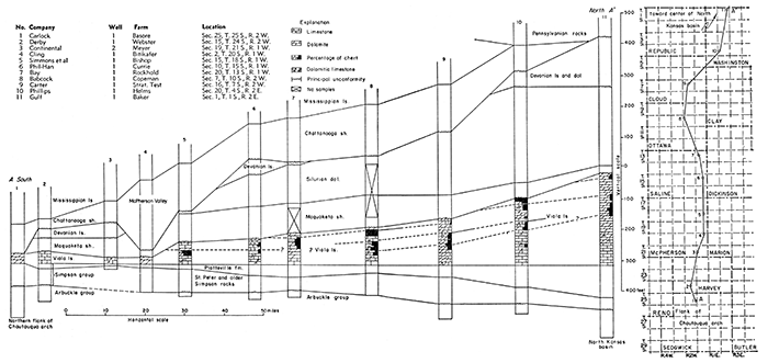
Figure 4 is a cross section from Sedgwick County north to Washington County, which shows the quantitative distribution of chert in the Viola based on percentage logs by Constance Leatherock. The correlation of the cherty zones by the writer is admittedly speculative, but the cross section illustrates the difficulties involved in using the cherty zones as datum beds.
Figure 4--Cross section A-A' from south to north showing (a) irregular distribution of chert in Viola limestone, and (b) northerly thickening of pre-Devonian formations. [Larger version available as an Acrobat PDF file.]
The lack of continuity in the presence and position of cherty dolomite suggests intraformational disconformities, but no definite interruption of the sequence is determinable. The changes from dolomite to limestone and from limestone to dolomite and the dissimilarities in the chert content at apparently the same horizon in wells only a few miles apart are regarded as the result of facies variations.
South of T. 12 S., a zone of coarsely crystalline noncherty limestone mottled by shapeless dark-gray to black organic stains is conspicuous at the base of the formation in both sample and electric logs. In a few wells in the southern part of the area, this zone consists of similarly mottled coarsely crystalline dolomite or dolomitic limestone. In some wells in the southern part of the area the limestone has a mealy matrix in which coarser granules are embedded. This phase of the lower zone locally includes well-rounded semitranslucent grains of crystalline limestone that are optically so similar to rounded quartz sand that they can be distinguished as limestone grains only by hardness or acid tests. The calcite grains so closely resemble the quartz sand in similar rocks at the top of the Simpson that in some wells of record the enclosing rock has been erroneously logged as sandy limestone. Northward from T. 12 S., as the center of the North Kansas basin is approached the basal zone is interstratified with and grades into dolomite. The mottled basal limestone is, however, represented in sec. 1, T. 1 S., R. 2E.
The unconformity between the Viola dolomite and the Maquoketa shale is illustrated graphically by the cross sections of Figures 5, 6, 7, and 8. The eroded character of the Viola surface is also indicated by the occurrence in some wells of a clastic deposit at the base of the Maquoketa. This clastic bed is thin and includes fine granules of limestone and dolomite embedded in characteristic Maquoketa shale. Although probably overlooked in the examination of the cuttings from many other wells, it was recognized in the following wells:
| Ingling No. 1 Anderson | sec. 10, T. 16 S., R. 2 W. |
| McBride et al No. 2 Tolle | sec. 21, T. 17 S., R. 1 W. |
| Lowell No. 1 Greenwood | sec. 28, T. 18 S., R. 1 W. |
| Texas-Pacific No. 1 Peterson | sec. 17, T. 18 S., R. 2 W. |
| Deep Rock No. 1 Miller | sec. 27, T. 18 S., R. 2 W. |
| Dickey No. 1 Reusser | sec. 26, T. 21 S., R. 2 W. |
| Westgate-Greenland No. 1 Hegerty | sec. 36, T. 22 S., R. 5 W. |
| Appleman No. 1 McManus | sec. 29, T. 15 S., R. 6 W. |
In the northeastern corner of the area the lower zone of the Viola, which includes both limestone and dolomite, is 35 to 50 feet thick. The thickness decreases irregularly to less than 20 feet in the south, where in many places the Viola is overlain unconformably by Maquoketa shale or by Chattanooga shale.
The Viola limestone, as a whole, reaches a maximum known thickness of 295 feet in well 11, Figure 4, in sec. 1, T. 1 S., R. 2 E., Washington County, Kansas, and it is 272 feet thick on the Kansas-Nebraska line in sec. 31, T. 1 N., R. 1 E., Jefferson County, Nebraska. It thins as a whole with some irregularity toward the southwestern margin of the North Kansas basin. In T. 24 S., R. 2 W., Harvey County, Figure 4, where only the basal limestone member of the Viola has survived, its total thickness is only 40 feet.
Pre-Maquoketa erosion reduced the thickness of the Viola, and in many wells it is represented only by a part of the basal zone of coarsely crystalline limestone. Less than 15 feet of lower Viola survives in parts of Reno, Harvey, and Butler counties. In parts of Marion, McPherson, and Reno counties pre-Chattanooga erosion removed the Maquoketa cover and reexposed the Viola. In the Wakefield No. 1 Goering well in sec. 14, T. 25 S., R. 6 W., both the Viola and Maquoketa were removed and the Chattanooga overlies the Simpson.
As shown in the cross section of Plate 2, pre-Maquoketa erosion roughly beveled the Viola. The rude beveling that thinned the Viola toward the south suggests that at least a part of the regional subsidence of the North Kansas basin occurred before Maquoketa time.
Westward, the thickness of the Viola increases abruptly to 115 feet in the Aylward et al. No. 1 Newell well in sec. 6, T. 25 S., R. 11 W., in Stafford County (well 1, cross section A-A' of Fig. 5), on the west side of the Maquoketa erosional basin and west of the deeper part of the pre-Chattanooga valley.
Figure 5--Cross section A-A' from southeastern Stafford County to northeastern McPherson County showing (3) unconformities at base of Maquoketa shale, at base of Devonian limestone, and at base of Chattanooga shale; (b) facies variations of Maquoketa shale, and (c) transition to impure cherty and sandy limestone in well 1. Well 13 shows outlier of Silurian oolitic dolomite capped by Devonian sandy dolomite. [Larger version available as an Acrobat PDF file.]
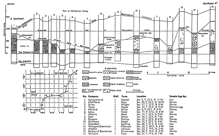
A thickness of 175 feet of Viola has been reported toward the west in the Musgrove No. 1 Roelfs well in sec. 21, T. 16 S., R. 9 W., (well 1, cross section B-B', Fig. 6). The lower 60 feet is coarse crystalline limestone typical of the basal zone of the Viola. The upper 115 feet of this sequence, except the uppermost 25 feet of cherty dolomite, consists of mealy siliceous and cherty limestone, argillaceous chalk, and marl yielding argillaceous insoluble residues. Despite the calcareous nature of the sequence, unusual in the Maquoketa, the writer regards the upper 115 feet as Maquoketa on account of the argillaceous character of most of the cuttings as shown also in well 1, cross section B-B', Figure 6.
Figure 6--Cross section B-B' from Ellsworth County east to Morris County showing (a) unconformity at the base of the Maquoketa shale, and (b) lateral transition of shale to cherty shale, cherty dolomite, impure cherty limestone, and marl. [Larger version available as an Acrobat PDF file.]
Pre-Chattanooga erosion very generally cut below the contact of the Maquoketa with the Viola on the western margin of the pre-Maquoketa erosion basin, as shown in cross section A-A' of Figure 5. The contact of the Viola and Maquoketa seems to have survived, however, in a few areas as in sec. 6, T. 25 S., R. 11 W. (well 1, cross section A-A', Fig. 5), where the Viola increases fairly abruptly to more than 100 feet. The Viola continues to thicken westward into the Hugoton embayment, where Maher and Collins (1949, sheet 1) report more than 200 feet of Viola beneath Mississippian limestone.
In the Hugoton embayment, southwest of the Central Kansas uplift, the normal sequence of Maquoketa, Silurian, Devonian, and Chattanooga rocks between the Viola and the Mississippian is missing. It must be assumed that, at some time after Viola deposition, the region of the Hugoton embayment was a positive and rising area. It was either too high to receive sediments between Viola and Mississippian time or the formations were deposited, raised, and eroded during one or more of the periods of erosional truncation so clearly exhibited in eastern Kansas. In any case a greater thickness of Viola limestone must originally have been deposited in the Hugoton embayment than is now preserved.
In the Salina basin area, the wide distribution of the basal limestone member indicates the absence of important erosional relief at the contact of the Viola with the underlying Simpson rocks.
Porosity in the Viola, as indicated by microscopic cavities and loosely interlocked grains of granular and sucrose dolomite, is confined to the upper 5 to 50 feet. Where the upper beds are especially cherty, the porosity occurs mainly in the dolomite or cherty dolomite beneath the zone of maximum chert concentration.
Maquoketa Shale
The Maquoketa shale, the youngest of the Ordovician formations in northeastern Kansas, is named for outcrops-on Maquoketa River in northeastern Iowa and is exposed in adjoining areas of Illinois, Wisconsin, and Minnesota, and in southeastern Missouri and southern Illinois. The Maquoketa is widespread in the subsurface and extends westward in Kansas at least to the Central Kansas uplift. Southward its equivalent, the Sylvan shale, occurs throughout most of eastern Oklahoma.
The character of the Maquoketa shale in northeastern Kansas is variable and in different areas the Maquoketa is composed of one or more of the following rocks: argillaceous shale, dolomitic shale, silty shale, and dolomitic silty shale, argillaceous dolomite, and cherty and siliceous dolomite. No limestone or calcareous shale has been observed in the Maquoketa except toward the west in well 1 of cross section A-A', Figure 5, and in wells 1 and 3 of cross section B-B', Figure 6.
The shales of the Maquoketa range from dark gray and greenish gray to dark green. Most of the shales are dolomitic. Some are silty, siliceous, and cherty. Insoluble residues, especially from samples of wells toward the northeast, display molds of free dolomite crystals in spongy coherent silt or silica. Toward the southwest fine dolomite molds pit the chert. The most common type of shale is dolomitic and includes more or less thinly disseminated fine crystals or interlaminated argillaceous grainy dolomite. The Maquoketa includes fine subangular sand in T. 2 S., R. 13 W., and similar fine sand grains are embedded in limestone in the Aylward et al No. 1 Newell well in sec. 6, T. 25 S., R. 11 W. Some of the shales, particularly toward the southern part of the area, include fine dark particles of what seem to be disintegrated graptolites.
The Maquoketa dolomite is gray to dark gray, grainy, composed of fine crystals set in an argillaceous or silty matrix. The impure dolomite of the Maquoketa contrasts sharply with the clean sucrose or coarsely crystalline dolomite of the Viola.
The chert is similar to that in the Viola. It is gray and opaque, bluish gray semiopaque, or chalcedonic, and encloses silicified fine fragments of microfossils and spicules. Like that of the Viola, the Maquoketa chert is in many places flecked and peppered with dark fragments of disintegrated graptolites. Some of the semiopaque gray chert is massive or laced with white spicules. Some of the siliceous beds are dolomitic and some in T. 25 S., R. 11 W., and T. 16 S., R. 9 W., are calcareous.
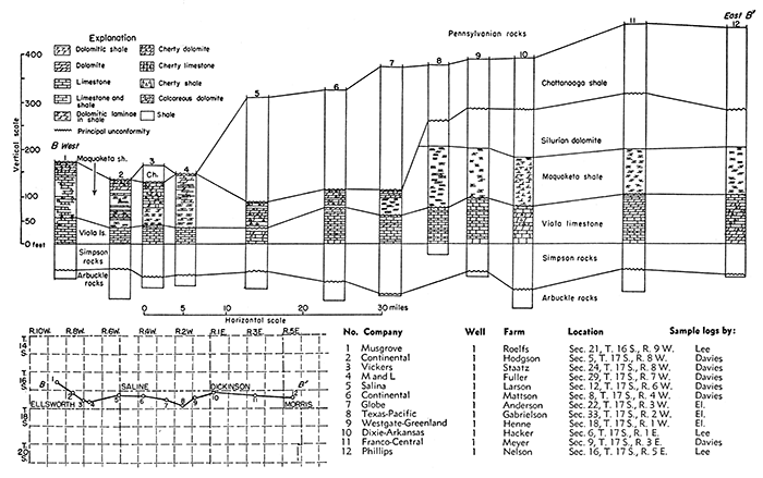
Cross section C-G of Figure 7, from McPherson County to Nemaha County, shows the variations in the lithology of the Maquoketa and the relation of the Maquoketa to the eroded surface of the Viola. The occurrence of chert in silty dolomitic Maquoketa shale in wells 10, 11, and 12 in Jefferson, Brown, and Nemaha counties is of interest because of the common occurrence of similar chert in wells farther southwest in Saline and McPherson counties. Examination of samples and residues from well 11 reveals that the Maquoketa shale, which is 93 feet thick, consists, in descending order, of 28 feet of argillaceous dolomite with traces of flecked chert; 40 feet of silty and siliceous dolomite with 10 to 20 percent of insoluble residues consisting of variegated dense and spongy dolomitic chert or cemented silt; and at the base 25 feet of argillaceous shale in which fine dolomite crystals are thinly disseminated. In well 10 the Maquoketa consists of 50 feet of dolomitic shale, containing a 12-foot zone near the middle that yields insoluble residues of spongy and chalcedonic chert. Southwestward from well 10 on the line of the cross section, the Maquoketa consists of greenish-gray shale interbedded or interlaminated with dolomitic shale as far as well 4. In well 3 the Maquoketa thickens to 142 feet. The upper 55 feet is dark-green shale with traces of flecked chert underlain by 52 feet of silty and argillaceous grainy gray dolomite with traces of similar chert, and 35 feet of dark-green shale.
Figure 7--Cross section C-C' from McPherson County northeast to Nemaha County showing gradation of parts of Maquoketa shale to dolomite and sparsely cherty dolomite toward the southwest in well 3. [Larger version available as an Acrobat PDF file.]
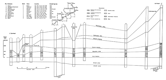
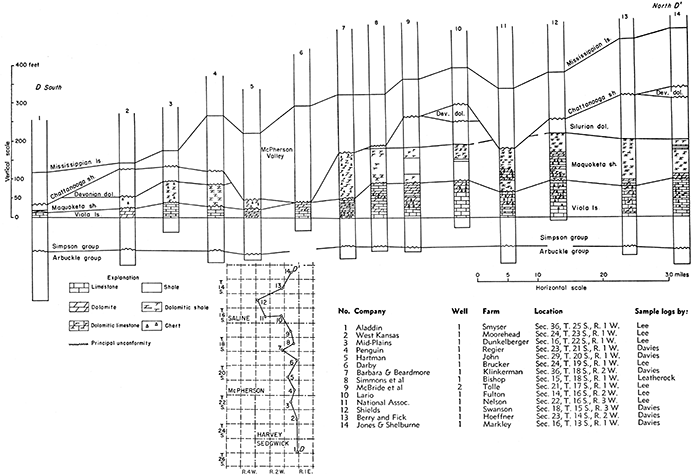
Figure 8--Cross section D-D' from Sedgewick County north to Saline County showing (a) lateral gradation of parts of Maquoketa shale to cherty dolomite, and (b) unconformity at base of Maquoketa. [Larger version available as an Acrobat PDF file.]
Cross section B-B', Figure 6, from Ellsworth County to Morris County, shows the transition of the lower part of the Maquoketa from dolomitic shale to cherty dolomite in wells 5 and 6 in northern McPherson County. In wells 1 and 3 the formation consists chiefly of very cherty chalky limestone and marl, in part dolomitic, but irregularly interbedded with calcareous shale and grainy dolomitic shale.
Cross section D-D' of Figure 8, from Sedgwick County to Saline County, again shows the transition from Maquoketa dolomitic shale to cherty dolomite in western Saline County, and the progressive substitution of the Viola by the Maquoketa from north to south. It also shows roughly the truncation of the Maquoketa and Silurian rocks by pre-Devonian erosion and the local removal of the Devonian and Maquoketa in the McPherson valley eroded during the hiatus that preceded the deposition of the Chattanooga shale. An example of abrupt transition is shown in well 12 of cross section D-D', Figure 8, in which the lower 53 feet consists of cherty argillaceous dolomite interbedded with dolomitic shale, but the upper 50 feet is noncherty dolomitic shale. The variability of the Maquoketa sequence is illustrated also by the change between this well and the Appleman No. 1 McManus well in sec. 29, T. 15 S., R. 6 W., only 16 miles away, in which the Maquoketa samples represent 140 feet of argillaceous and dolomitic shale containing only traces of gray argillaceous and silty dolomite and limestone in the lower 50 feet.
Cross section A-A', Figure 5, from McPherson County to Stafford County, shows the thickening of the Maquoketa at the expense of the Viola, the elimination of the Maquoketa from wells 2 to 7 by pre-Chattanooga erosion, and the presumed reappearance of the Maquoketa in Stafford County in well 1 as argillaceous, cherty or siliceous chalky limestone with embedded fine sand and silt and yielding insoluble residues of tripolitic silica.
In well 1, 50 feet of pure, cherty, chalky limestone and calcareous chert seems to represent the Maquoketa. Insoluble residues of the base and middle of the Maquoketa in this well yield fine subangular sand embedded in limestone and spongy chert. The presence of sand may be an indication of approach to a shore line.
Fine subangular sand also occurs below very dark gray extremely pyritiferous shale between the Silurian and the Viola in the Mid-Kansas No. 1 Borgan well in sec. 4, T. 2 S., R. 13 W. The Maquoketa is only 30 feet thick in this well and seems to represent a pinchout or marginal deposit on the flank of a mild initial stage of the Central Kansas uplift.
The thickness of the Maquoketa where it is normally overlain by the Silurian and not cut off by later unconformities ranges from 30 feet to 142 feet. It is 30 feet thick in the Mid-Kansas No. 1 Borgan well in sec. 4, T. 2 S., R. 13 W., and in the Murfin No. 1 Wessling well in sec. 35, T. 6 S., R. 7 W., where it displays the normal character of greenish-gray dolomitic shale. In the northern part of the area it is generally less than 65 feet thick, although locally, as in wells in T. 4 S., R. 15 and 16 W., it thickens to about 95 feet. The thickness increases irregularly toward the south and southwest, and in Saline and McPherson counties it averages somewhat more than 100 feet, ranging from 80 feet in sec. 24, T. 17 S., R. 2 W., to 142 feet beneath a Silurian outlier in sec. 20, T. 19 S., R. 2 W. The irregularities in thickness are due in large part to topographic relief of the eroded surface of the underlying Viola as illustrated in the cross sections, Figures 6, 7, and 8.
The Maquoketa has not been reported southwest of the Central Kansas uplift. The increase in the proportion of carbonates in the most western wells in which the Maquoketa is recognized suggests that westward it may become indistinguishable from the Viola. On the other hand the relations suggested in cross section A-A', Figure 5, and the sandy beds at the base of the Maquoketa in well 1 suggest that the Maquoketa overlapped on topographically high Viola that remained above the level of Maquoketa deposition near the margin of the Maquoketa basin.
There is some reason to suspect that an inconspicuous disconformity separates the Maquoketa from the Silurian. This supposition is based on the variable position of the oolitic dolomite zone of the Silurian, which in some places is 30 feet or more above the Maquoketa and in others is in contact with it. This theory is supported by discrepancies in the thickness of the Maquoketa in nearby wells in which the thickness of the Viola is uniform. The topographic relief in any case is low and negligible.
Rocks of Silurian Age
The limestone and dolomite lying between the Maquoketa shale and the Chattanooga shale are conveniently referred to as the Hunton formation or group by oil operators and petroleum geologists. Study of this sequence has revealed that it includes both rocks of Silurian age and rocks of Devonian age. Unconformities at the bottom and top of the Devonian part have so restricted the distribution of the separate parts of the Hunton in Kansas and Oklahoma that either the Silurian or Devonian beds may be present alone or in combination with parts of the other. The term Hunton has thus become ambiguous except in the sense that it includes all the carbonate rocks between the Maquoketa and Chattanooga shales.
Silurian rocks crop out at intervals from the Arbuckle Mountains in Oklahoma through central Arkansas, thence northward around the Ozark uplift to southeastern Missouri, thence to northeastern Iowa and parts of adjoining states. These rocks include the Alexandrian Series of Savage (1908) at the base of the Silurian, consisting in ascending order of the Cape Girardeau limestone, Edgewood limestone, and Brassfield or Sexton Creek limestone. In some areas outside Kansas, rocks of Alexandrian age are overlain by the Bainbridge limestone or its correlatives of the next younger Niagaran Series. The oldest of the Silurian rocks in Oklahoma is the Chimneyhill limestone, which includes equivalents of the Noix oolite member of the Edgewood limestone and the Brassfield limestone of Missouri and Illinois. In Oklahoma, the Chimneyhill is overlain by the Henryhouse shale, which is believed by some geologists to represent the Bainbridge of the Mississippi Valley. Some of the Silurian rocks of north-central Kansas are correlated with the Chimneyhill of Oklahoma (Lee, 1945, p. 44-45). Younger Silurian rocks may be represented in parts of northeastern Kansas, but they have not been differentiated.
The Chimneyhill limestone and its correlatives and the overlying Silurian rocks are widely distributed in the subsurface. They were probably originally deposited throughout the region from the outcrops in the Mississippi Valley across the Ozarks and at least to central Kansas and central Oklahoma. Upwarping and erosion have removed all the Silurian rocks from the central Ozarks and from the crests of anticlinal structures in Kansas, including the Chautauqua arch, the Nemaha anticline, and the Central Kansas uplift. In outcrops in southeastern Missouri and southern Illinois, unconformities have been recognized at the base of the Edgewood limestone, of Brassfield age, and at the base of the Bainbridge.
There are several recognizable zones in the Silurian sequence of Kansas. They have well-defined limits in some wells, but their separation in others is vague and unsatisfactory. These may be described in ascending order as the oolitic zone, the white chert zone, the foraminiferal zone, a siliceous and cherty zone, and a non cherty zone of alternating dolomite and limestone. These zones are clearly defined in areas near the center of the basin, but toward the margin lithologic diversity makes zoning difficult or impossible.
The first or oolitic zone, which overlies the Maquoketa, is everywhere composed of sucrose or fine-grained dolomite characterized by dolomitized oolites. The oolites are composed of sucrose dolomite, and their surfaces are roughened by minute crystals of dolomite. In some samples the oolites are touching, without matrix. In others they are embedded in the matrix, which in some places displays voids left by the removal of fossil fragments. In some wells the oolites resemble grains of soft dolomite worn to roundish surfaces in drilling. The abundance of the oolite is variable, and the variation in thickness of the zone may be due either to poor preservation of the oolites or to their irregular distribution. In the absence of recognizable oolites, the zone is generally represented by the sucrose dolomite typical of this zone. Small amounts of oolitic white chert were noted in this zone in the following wells: the B. B. Blair No. 1 Cox well in sec. 10, T. 4 S., R. 7 E., the Wolf Creek Oil Company No. 1 Brenizer well in sec. 35, T. 12 S., R. 2 E., the Bay Petroleum Corporation No. 1 Rockhold well in sec. 20, T. 13 S., R. 1 W., and the Hutchinson No. 1 Ehrmann well in sec. 15, T. 18 S., R. 1 E. In the W. A. Haney No. 1 Faidley well in sec. 27, T. 10 S., R. 1 W., the centers of the oolities and some of the openings have been filled with chalcedony, leaving fragments that superficially resemble rounded grains of quartz sand. The thickness of the Silurian in this well is nearly twice that in the nearest wells in adjoining townships, although the thickness of the other pre-Pennsylvanian formations is normal. This fact, the unusual chalcedonic replacements, and the presence of excessive amounts of quartz and siliceous dolomite in the middle part of the Silurian suggest the possibility that this well was drilled through a fault in the Silurian. The oolitic zone is missing in parts of Cloud and Mitchell counties and in scattered wells elsewhere, especially toward the southern margin of the North Kansas basin. It is not represented in samples from a cable tool well in the NW corner SW sec. 27, T. 14 S., R. 2 W., nor in samples from a well in the NW corner sec. 30 of the same township. It is, however, well developed in 12 other wells in this township, a relationship that suggests that its seeming absence may be due to poor samples rather than nondeposition.
The insoluble residues of samples from this zone generally constitute less than 2 percent by volume and consist of fine particles of hackly and drusy quartz and silt. The zone is correlated with the Noix oolite member of the Edgewood limestone of northeastern Missouri, which was correlated by Ulrich (1930, p. 73) with the basal beds of the Chimneyhill of Oklahoma.
Except for local areas in which it is absent, the oolitic zone is coextensive with the Silurian. It reaches its greatest thickness of 60 feet in the northern part of the area in the Phillips No. 1 Helms well in sec. 20, T. 4 S., R. 2 E.; it is only 7 feet thick in the Blair No. 1 Cox well in sec. 10, T. 4 S., R. 7 E., and 10 feet thick in the Carter No. 1 stratigraphic test in sec. 16, T. 7S., R. 2 W. The zone thins irregularly toward the south, where it is commonly less than 5 feet thick or absent.
The second or white chert zone normally overlies the oolitic zone, but it was not developed in some areas. The zone consists mainly of medium to coarse crystalline dolomite that generally includes only minor amounts of white opaque chert or dense tripolitic white chert. In the Phillips No. 1 Helms well in sec. 20, T. 4 S., R. 2 E., where the Silurian is especially cherty, 35 feet of coarsely granular dolomite containing 10 to 40 percent white opaque chert overlies the oolitic zone. The cherty zone diminishes in thickness toward the south and is missing or noncherty in many wells. The zone is 15 feet thick in the Turner No. 1 Umsheid well in sec. 32, T. 8 S., R. 9 E., and in the Lashelle No. 1 Umsheid well in sec. 16, T. 9 S., R. 9 E. In the Wolf Creek No. 1 Brenizer well in sec. 35, T. 12 S., R. 2 E., it is only 5 feet thick. Only traces of white chert occur directly above the oolitic beds in some of the wells in Saline and Dickinson counties. Chert seems to be absent farther south.
The third zone, which includes foraminifera, extends upward from the cherty dolomite to the base of a well-developed siliceous dolomite. Toward the center of the North Kansas basin this zone consists entirely of dolomite, but like other deposits in the basin it becomes increasingly interstratified with limestone toward the margin. The dolomite in the lower part of the zone is dense to sucrose and of fine texture, but the upper beds are coarsely crystalline and coarsely vuggy, many voids resulting from the solution of fossil fragments. The limestones in areas marginal to the North Kansas basin are semigranular, mealy, or sublithographic. The lower limestone beds contain embedded grains of dolomite. In some wells, as in the Arab No. 1 Ogle well in sec. 9, T. 1 N., R. 14 E., in Nebraska, the lower beds of this zone include pink and red dolomite, and in Dickinson County and adjoining areas the beds are red and argillaceous. In the Arab No. 1 Ogle well, the two lower zones are absent or not identified and the foraminiferal zone seems to be in contact with the Maquoketa.
Where the sequence is normal, the fine-grained dolomites of the third zone and their limestone correlatives on the margin of the North Kansas basin are characterized by the presence of diffusely distributed foraminifera of species resembling Ammodiscus and Lituotuba present in the Silurian of Oklahoma but unreported from the Devonian (Ireland, 1939). Similar foraminifera have been reported from the Brassfield limestone of the Mississippi valley, with which this zone is correlated. The insoluble residues from 5-gram samples (usually less than 2 percent) rarely yield as many as 6 specimens, and some contain none. These foraminifera occur at a depth of 1,530 feet, 90 feet above the white chert zone in the Coronado No. 1 Parks well (a cable tool well) in sec. 16, T. 10 S., R. 8 E., but foraminifera are only infrequently found more than 40 feet above the zone of white chert. On the southern margin of the North Kansas basin, where the dolomite beds are interstratified with limestone, Ammodiscus has been found in limestone as well as in dolomite. It occurs in pink limestone directly below semiopaque chalcedonic chert 75 feet above the oolitic zone in the Auto-Ordnance No. 1 Gawith well in sec. 27, T. 11 S., R. 5 W., at a depth of 3,620 to 3,625 feet. It occurs also in semigranular limestone directly above the oolitic zone in the Auto-Ordnance No. 1 Ruch well in sec. 25, T. 13 S., R. 2 W., and in the same position in earthy semigranular limestone in the Northern Ordnance No. 1 Warner well in sec. 10, T. 15 S., R. 3 W., and in wells in sec. 30, T. 15 S., R. 2 W., and in sec. 17, T. 15 S., R. 1 W.
The zone is generally noncherty, but in the Phillips No. 1 Helms well in sec. 20, T. 4 S., R. 2 E., dolomite at the depth of this zone, but possibly not its correlative, includes 10 to 40 percent chert. The chert in the lower part is mottled and spicular and that in the upper part massive, vitreous, and varicolored. It may be that the varicolored cherty dolomite in this well and in wells farther west, in place of the normal noncherty dolomite, indicates a mid-Silurian disconformity rather than a facies variation. In most wells in Cloud and Mitchell counties in which the oolitic zone has been identified, the oolitic zone is overlain by a sequence of limestone and dolomite and massive semiopaque vitreous chert of shades of gray and yellow to pink and red, unlike the lithology of the third zone in most areas but resembling the less vivid vitreous cherts in the Phillips No. 1 Helms well described above.
The third zone is 165 feet thick in the Ohio No. 1 Lamparter well in sec. 3, T. 2 S., R. 14 E., near the center of the North Kansas basin. Its thickness decreases somewhat irregularly toward the south to 55 feet in the Bay Petroleum Company No. 1 Rockhold well in sec. 20, T. 13 S., R. 1 W., and 40 to 60 feet in wells in T. 14 S., R. 2 W. Westward in Cloud and Mitchell counties, rocks assigned to the third zone consist of an irregular relatively thin sequence of varicolored (red, pink, lemon yellow to gray) dolomite and limestone. The upper part of this sequence is extremely siliceous and contains a large amount of varicolored semiopaque massive chert.
The fourth zone is composed mainly of dolomite but includes minor amounts of interbedded limestone toward the southwest in the usual gradation from central to marginal areas of the North Kansas basin. This zone is siliceous, but the insoluble residues, which include both quartzose and cherty materials, are extremely variable in character and in volume, ranging from a trace to 10 percent. The insoluble residues include quartz crystals, hackly quartz, drusy quartz, spongy silica, and silt. The cherty residues of this zone include grainy opaque chert, semiopaque chert, and soft white opaque chert resembling tripoli. The quartz crystals are confined to the upper 5 to 40 feet of this zone, and where present identify the fourth zone in the basin areas. Toward the margin of the basin the quartzose residues diminish in volume and disappear, and the residues become increasingly cherty. The fourth zone is normally 65 to 75 feet thick in basin ward areas, but toward the south and west it was removed by pre-Devonian erosion.
The fifth zone consists of interbedded limestone and dolomite, whose insoluble residues are of negligible volume. It attains a maximum known thickness of 140 feet in the Ohio Oil Company No. 1 Lamparter well in sec. 3, T. 2 S., R. 14 E., (well 14, Pl. 3), but it is absent toward the south and west on account of pre-Devonian erosion.
Toward the southwestern margin of the North Kansas basin, the entire Silurian sequence grades into coarsely crystalline white limestone as much as 40 feet thick overlain by cherty dolomite as much as 80 feet thick. The chert is varicolored, vitreous, and semitranslucent. These rocks are correlated with the Silurian because of the similarity of the chert to that of zone 3 in the Phillips No. 1 Helms well in sec. 20, T. 4 S., R. 2 E., and because sandy Devonian limestone overlies these cherty beds in the Livermore No. 1 Froelich well in sec. 30, T. 5 S., R. 10 W., and in other wells in the vicinity.
In Kansas the Silurian rocks overlie the Maquoketa shale in seeming conformity, but differences in the interval from the top of the oolitic zone to the top of the Maquoketa suggest a slight dis conformity between them. The Silurian is separated from the overlying Devonian rocks by an important unconformity (cross section C-C', Fig. 7), caused by erosion that beveled older rocks as far down as the Arbuckle. This surface was an imperfect plain in central Kansas. Topographic relief of 80 feet or more is revealed by variations in the thickness of the Silurian beneath its contact with the Devonian in Ottawa and Dickinson counties. Lesser relief occurs in other areas.
Plate 2 shows the present distribution of the Silurian rocks. They were originally deposited throughout the area, but during repeated periods of uplift and erosion were worn away from certain areas. As shown in cross section A-A' of Plate 2 and Figure 4, the Devonian rests on progressively thinner remnants of the Silurian toward the south. The Silurian where it is overlain by the Devonian is 445 feet thick in the Ohio No. 1 Lamparter well in sec. 3, T. 2 S., R. 14 E. Its thickness diminishes to 16 feet on an outlier capped by Devonian in the Aladdin No. 1 Johnson well in sec. 20, T. 19 S., R. 2 W. (well 3, Fig. 7). Farther south the Silurian is missing where the Devonian overlaps upon the Maquoketa shale. Pre-Mississippian erosion removed the Silurian from flank areas of the Central Kansas uplift, where its thickness had already been reduced by pre-Devonian erosion. The Silurian was removed from the highest parts of the Nemaha anticline by pre-Pennsylvanian erosion.
Prev Page--Stratigraphy--Precambrian to Cambrian || Next Page--Stratigraphy--Devonian
Kansas Geological Survey, Geology
Placed on web Jan. 5, 2017; originally published Dec. 1956.
Comments to webadmin@kgs.ku.edu
The URL for this page is http://www.kgs.ku.edu/Publications/Bulletins/121/03_strat2.html