![]()
Prev Page--Stratigraphy, Tertiary, Quaternary || Next Page--Oil and Gas
Structure
Regional Structure
Cowley County is situated on the Prairie Plains monocline, which constitutes the western flank of the Ozark uplift and involves an extensive region in western Missouri, eastern Kansas, and northeastern Oklahoma in which the strata dip at a low angle westward. In the northeastern part of this general region the direction of dip swings to the northwest, and in the southeastern part it is toward the southwest. The rate of dip is usually reported to average about 30 feet to the mile in eastern Kansas. Ley (1924) states that the rate of dip rarely exceeds 40 feet to the mile. The Fort Scott limestone has a total fall of a little more than 2,700 feet from its outcrop near Oswego, Labette County, due westward 110 miles to the Rainbow Bend oil field in Cowley County. This is an average component dip of about 25 feet to the mile. It is largely this regional westward tilt of the beds that causes the formations to crop out in parallel bands in eastern Kansas, each successive band toward the east exposing stratigraphically lower and older strata.
In Cowley County, as well as elsewhere on the Prairie Plains monocline, the prevailing attitude of the strata is modified locally by departures from the westward tilt. The deviations range from a steepening of the westward dip through horizontality to eastward or reverse dips. It is on the structural features formed by these local variations upon the Prairie Plains monocline that many of the important oil fields have been developed.
Several writers have recently given summaries of the characteristics of the structural features of the Prairie Plains monocline in northeastern Oklahoma and southeastern Kansas, from which the following statements are largely taken (Powers, 1925; Ley, 1924; Rubey, 1923; Rubey and Bass, 1925, p. 72-75). The characteristic folds are anticlinal noses, domes, terraces, synclines, and basins, of small lateral extent, each commonly within an area 2 miles square. Some anticlines and synclines reach a length of 2 to 3 miles, but larger ones consist of groups of smaller features. In many folds the amount of closure increases with depth--that is, the beds at depth are more steeply folded; others, designated by Powers as surficial folds, disappear gradually downward, usually within the Pennsylvanian series. Commonly the axes of folds are inclined--that is, the crest of an anticline, for instance, as defined in the surface beds; does not directly overlie the crest as defined in some deeper bed. Most of the folds are irregularly arranged, but some are alined in more or less systematic plan. Most of the major-trend lines in eastern and central as well as western Kansas and northern Oklahoma have a northeast-southwest alinement.
History
Inasmuch as all strata in this region upward through the Permian series maintain the westward dip, as shown in the surface exposures, the tilting that gave the beds their present attitude is known to have occurred after the time of deposition of the Permian strata. Evidence less readily recognized in this part of Kansas, but disclosed by other workers from studies of subsurface data derived from well records and from surface studies carried on elsewhere in the general region, indicates that other important structural movements that affected the rocks in the region containing Cowley County occurred at earlier dates. Subsequent to the deposition of strata hundreds of feet thick, during Cambrian time and part of Ordovician time, which were laid down on an irregular surface of Pre-Cambrian igneous and metamorphic rocks, a pronounced uplift that centered in the locality of the present Ozark mountains affected an extensive region including northeastern Oklahoma and eastern Kansas (White, 1926, pl. 1; Edson, F. C., 1927, p. 968). Later in Ordovician time more sediments were deposited. Another uplift ended Ordovician sedimentation. The strata were then folded, uplifted, and subjected to erosion throughout a long period. The land was again submerged, and Silurian and Devonian sediments, interrupted by at least one period of uplift and erosion (Edson, F. C., 1927, p. 968), were deposited over parts of the region but failed to cover several anticlinal areas (Powers, 1925, p. 383) that stood as hills on the old surface and so formed islands in the sea. Slight uplift with some erosion followed, and then the region was submerged and received the deposits now known as the "Mississippi lime." After the deposition of the Mississippian beds there was a marked uplift. Gently inclined anticlines, domes, and synclines were formed, and some faulting occurred. Evidence of these phenomena, except the faulting, is present in Cowley County, and faulted Mississippian beds overlain by unbroken Pennsylvanian and Permian strata are reported in the Tonkawa and Thomas oil fields in Oklahoma, a short distance southwest of Cowley County (Clark, and Cooper, 1927). Deposition of the thick Pennsylvanian and Permian series followed, and other important events occurred later in Mesozoic time. It is evident, then, that many structural features that were formed in the deeply buried older rocks prior to the deposition and emergence of the surface beds will not be manifest in the strata now at the surface. For instance, the Cambrian and Ordovician beds, and perhaps others, probably dip westward in Cowley County at a steeper angle than the Mississippian and overlying beds and no doubt contain many structural features of local extent that remain unknown (White, 1926, pl. 1). However, many of the Ordovician folds are defined in the Mississippian and higher beds, with angles of inclination diminishing upward.
Local Structure of Surface Beds in Cowley County
Although the beds at the surface in Cowley County conform in general attitude with the Prairie Plains monocline, the local departures from the regional westward dip are so numerous as almost to obscure the broader relations when only a small area is considered. The deviations from the regional attitude consist of anticlinal noses, terraces, anticlines, synclines, domes, and basins. Most of the area of Cowley County has been mapped in detail with reference to the attitude of the surface beds by oil-company geologists, but little information of this nature was available for study in connection with this report, and no work of this type was done by the writer in the field. It is known, however, that all the folds have only very low dips, rarely exceeding 10, and that some of the small and all of the major folds have a northeast-southwest alinement, in harmony with the pattern made by the chief trend lines of folding in the general region.
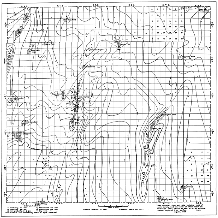
Of all the structural features in the county the Dexter anticline, shown in part in figure 18, has the most pronounced expression in the surface beds. It is an asymmetric fold with its steeper flank on the east, trending nearly due north for several miles near Otto, thence swinging to the northeast near Dexter. According to Clark and Cooper the trend of the fold continues southwestward through the Mervine and Ponca anticlines in Oklahoma (Clark and Cooper, 1927, p. 24). In the vicinity of Dexter the beds dip eastward as much as 100 feet in half a mile and westward about the same amount in a mile. Numerous structural sags or saddles cross the anticline, thus forming a series of local "highs." A fold of similar type that is believed to overlie the "granite ridge" lies in the northwestern part of Cowley County, crossing the western boundary of the county about the middle of the west line of T. 31 S., R. 3 E., trending northeastward, passing about half a mile west of Udall, thence northeastward crossing the north boundary of the county on the north line of the NE, sec. 3, T. 30 S., R. 3 E. This is a part of a series of folds that trend northeastward across Kansas, including the Augusta, El Dorado, and Burns anticlines, and southwestward far into Oklahoma, through the Blackwell, Retta, Thomas, and Garber fields (Clark and Cooper, 1927, p. 26). As on the Dexter anticline, local "highs" of pronounced structural relief are present on this fold. There is one that centers about the town of Oxford, and another a short distance northeast of Oxford on which are located the Oxford and Churchill (South Udall) oil pools, both largely outside of Cowley County. Another local dome that produces oil lies about 2 miles north of Udall, and another on which two dry holes have been drilled is in sec. 10, T. 30 S., R. 3 E. As in the Dexter fold, the east limb of the "granite ridge" anticline in Kansas is steeper than the west limb, but the angle of inclination of the beds is probably greater than in the Dexter fold. Unlike that of the Dexter fold, however, the attitude of the beds throughout much of this region is not determinable from surface observation, because the surface is immediately underlain by a thick body of soft shale beds that contain no readily traceable hard layers that might serve as datum planes for mapping. The attitude of the beds has been determined by core drilling at regular intervals throughout the region. The procedure followed in drilling an area to obtain structural data is usually as follows: A core of the rocks penetrated is taken in the first few wells drilled in the region to locate the approximate depth of some bed suitable to serve as a "key" bed; subsequently, wells are drilled with a fishtail bit to a depth a short distance above the "key" bed and a core is taken of only the lower part of the hole--that is, through a relatively small series containing the "key" bed. In the western part of Cowley County wells are cored through the Herington limestone, which there lies at a shallow depth.
The Winfield anticline, which is about midway between the Dexter and "granite ridge" folds, trends approximately parallel to them and is discernible in the surface beds, the Winfield limestone and other traceable rock layers being widely exposed in the vicinity. The degree of dip of the surface beds is much less than in either of the other two folds, but like them this fold has the steeper dips on the east flank, and local constrictions divide it into a number of "highs" separated by low structural saddles. These three anticlinal folds, the Dexter-Otto, Winfield, and "granite ridge," are the three most extensive structural units evident in the surface beds in the county, and their general features are duplicated in many other lesser folds. Structural terraces, noses, domes, synclines and basins are numerous. Although features such as the Dexter anticline are striking because of their size, it is the noses, small domes and anticlines, and shallow basins that are most abundant in the county and so constitute the typical structural features. Many of these, although by no means all, have an alinement similar to that of the larger features. The deviations in attitude from horizontality are generally so slight as to be impossible of detection with the eye, and it is only by detailed plane-table mapping, carrying accurate altitudes, that the true attitude of the beds can be determined.
Attitude of the Mississippian Surface
The Mississippian strata were deposited on the bottom of a marine sea, were later elevated above the sea and flexed into gently arched folds, and were finally subjected to a long period of erosion. Because the strata were hard and resistant erosion was more effective on the higher lands, which were also structural "highs"; consequently the result was similar to that obtainable by running a plane over a folded layer of wax or putty; the tops of the folds would be planed off, leaving the layer thinner at those localities. So it was with the Mississippian beds: the rocks at the tops of the folds were eroded away more rapidly than those on the flanks and in the downfolds, reducing the thickness over the crests of the structural "highs."
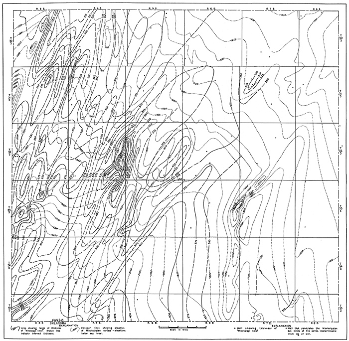
The upper surface of the Mississippian series is shown on Plate XI by contour lines representing levels at intervals of 50 feet. Accordingly it is a topographic map of the buried Mississippian surface, but because the topographic features of this surface appear to conform in large part with the structural features of the Mississippian beds the map represents also a modified picture of the attitude of these strata. This conformity of structure and buried topography was produced during the long period subsequent to folding of the strata, when erosion prevailed and this old surface was formed. The present strike of the Mississippian surface in Cowley County is approximately N. 35° W., and it slopes southwestward at an average rate of about 22 feet to the mile. It is highest near the northeast corner of the county, where it is 1,300 feet, below sea level, and lowest near the southwest corner, where it is 2,300 feet below sea level.
Plate XI--Contour map of the upper surface of the "Mississippi lime" in Cowley County. [A larger PDF version of this figure is available.]
The Mississippian beds are shown as being deformed in a series of elongate folds trending northeast, approximately parallel with the trend of the "granite ridge." Inasmuch as the data that served as a basis for the contouring were obtained solely from records of drilled wells, there are necessarily large areas for which information was lacking and the projection of the contours across these areas, which constitute a large percentage of the total, is purely hypothetical. The actual conditions are, without doubt, much more complicated than those illustrated in Plate XI, but the information available from well records unsupplemented by surface maps indicates the generalized structural pattern shown.
The largest structural features shown are the same folds that are most prominent in the surface folds--the Dexter, Winfield, and "granite ridge" anticlines--on each of which there are local domes. A fourth prominent feature is an extensive "high" that extends practically across the county about midway between the Dexter and Winfield folds. Only a few wells have been drilled in this region, and so the contouring is necessarily very much generalized and subject to radical changes. This anticline appears to be alined with and probably constitutes the southwestward continuation of the Beaumont arch, which extends northeastward across the southeast corner of Butler County to and probably beyond Eureka (Ley, 1924, p. 117).
Thinning of Mississippian Beds Over Structural Features. Because the thinning of the Mississippian series over the crests of the folds was accomplished by a removal of more of the upper part of the series there than in the troughs of the folds, a representation of the attitude of these strata must make due allowance for the variations in thickness. If such adjustments are made and a uniform thickness is assumed for the series, the structural features are greatly accentuated from the attitude shown on Plate XI. For example, from the crest of the Winfield anticline, in sec. 25, T. 32 S.,. R. 4 E., to the trough of the syncline three-quarters of a mile to the southeast the slope of the upper surface of the Mississippian amounts to about 110 feet. Data revealed by well logs indicate that the series is about 150 feet thicker in the synclinal trough than over the anticlinal crest. If the thickness was originally constant between the two points, the actual amount of eastward dip of the beds must then be the sum of these two amounts, which is 260 feet, A generalized picture of the thickness of the Mississippian series throughout much of Cowley County is presented on Plate XII by lines joining points of equal thickness (isopachous lines), and the attitude of the Mississippian surface is shown by dotted contour lines in order to show the relation between the two. The chief fact shown is that the Mississippian beds are much thinner over the crests of the folds than in the adjacent synclines. The actual relation is no doubt less simple and less systematic than that shown, but the data supplied by well logs furnish a general picture about as indicated.
Plate XII--Sketch map showing thickness of the "Mississippi lime" and its relation to the attitude of the Mississippian surface in Cowley County. [A larger PDF version of this figure is available.]
Mississippian Surface at Time of Burial
The upper surface of the Mississippian beds was a land surface that had been subjected to erosion for a long period prior to its burial by the Cherokee shale. During the time when sediments were accumulating upon this irregular surface deposits collected first in the low places and gradually encroached upon the higher parts, finally burying the entire surface of the Mississippian beds, including the highest hills. The surface of deposition was then essentially a horizontal plane. If the intervals between the surface of deposition and the buried erosion surface were known, the configuration of the buried surface could be indicated by a contour map similar to the representation of a sea or lake bottom based on measurements of the depths beneath the water surface. Any widespread layer such as a bed of limestone should represent the depositional surface at the time of its formation, and intervals between this limestone bed and the buried erosion surface could be calculated from records of drilled wells. There is no such marker bed close above the Mississippian surface that is readily recognizable in well logs, but the Fort Scott limestone, next above the Cherokee shale, provides such a datum plane. The position of the Fort Scott ranges from 125 feet to a little more than 300 feet above the Mississippian surface. On a map of the county (not shown here) contour lines were drawn representing the intervals between the base of the Fort Scott limestone and the upper surface of the Mississippian beds. If the Fort Scott limestone was deposited on a horizontal plane, and it probably did not depart much from horizontality, this map should show the attitude and conformation of the Mississippian surface at the beginning of Fort Scott time. The map indicates that the Mississippian surface sloped gently southeastward and was characterized by very low hills over the anticlines and domes, with intervening shallow valleys. The surface was nearly a peneplain. The topographic relief in the area of the Slick-Carson dome was only 10 to 15 feet, in the area of the Winfield anticline even less, and in the area of the Dexter-Otto anticline there was a maximum relief of 35 feet.
Structural Details of the Slick-Carson Dome
Only a few data relative to the structural features of the Ordovician beds are available in Cowley County, but it is known from well records obtained in the general region that these beds are commonly more steeply inclined over domes and anticlines than the upper surface of the Mississippian beds. Numerous wells in the Slick-Carson field of Cowley County have penetrated the Pre-Chattanooga beds, and the data revealed by them are in accord with those found elsewhere. Figure 7 shows the attitude of the upper surface of the PreChattanooga beds (Ordovician?), the Mississippian surface, and the base of the Fort Scott limestone, also the attitude of the Mississippian beds after restoration to a uniform thickness of 300 feet. The structure of the restored Mississippian surface, which should represent more nearly the true attitude of the beds, is not materially different from that of the Pre-Chattanooga surface, but the base of the Fort Scott limestone is much less steeply folded. Contouring on beds at higher horizons shows a progressive flattening upward, as is illustrated by the cross sections in Figure 7-E.
Figure 7--Structure contour maps of Slick-Carson field, T. 32 S., R. 3 E., Cowley County. A,Contours drawn on base of Fort Scott limestone. B, Contours drawn on surface of Mississippian rocks. C, Contours drawn on beds of Pre-Chattanooga age. D, Contours drawn on hypothetical restored top of Mississippian limestone, the series assumed to be 300 feet thick. E, Cross sections of figures A to D. (Neva limestone, represented, lies 600 feet beneath the present surface, 2,375 feet above the Fort Scott; contour map not shown.)
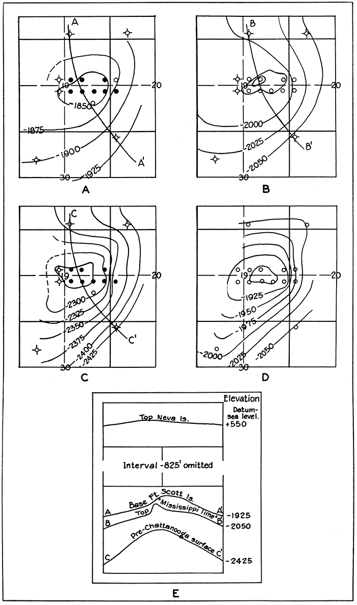
The flattening of the arch formed by the strata means a thicker prism of sediments on the flanks of the fold than on the crest. In the Slick-Carson field this thinning over the crest is slightly greater in the shale units than in the units occupied largely by limestone. This radial convergence in the shale toward the crests of the domes is a common phenomenon in dome-shaped folds in the Midcontinent region and is cited by Blackwelder in his discussion of the Mideontinent structural features as one of several criteria that suggest condensation of sediments over a buried irregular surface (Blackwelder, 1920, p. 94).
Origin of the Structural Features
Inasmuch as no conclusive data to show the origin of the structural features of this region were obtained from the study of Cowley County, nothing more than a brief summary of a part of the recent writings on this phase of the geology of the Midcontinent region will be given here. [Blackwelder, 1920, p. 89-94; Mehl, 1920, p. 520; Powers, 1922, p. 233-259; Gardescu and Johnson, 1921, p. 481-483; Monnett, 1922, p. 194-200; Fath, A. E., 1921, p. 75-84; Bloesch, 1919, p. 263-285; Gardner, 1917a, p. 685-720; McCoy, 1921, p. 541-584; Parks, 1924, p. 704; Rubey, 1923, p. 23-70; Rubey and Bass, 1925, p. 72-86; Heald, 1925, p. 388; Hedburg, 1926, p. 1035-1072; Rubey, 1927, p, 621-632; Charles, 1927, p. 28-35] Numerous writers, including Blackwelder, Mehl, Powers, Rubey, and others, have sought to show that many of the structural features of this region are formed by the compaction of the sediments over buried uneven surfaces, the irregularities on the Pre-Cambrian, Ordovician and Mississippian surfaces being chiefly effective, The theory advanced may be briefly summarized as follows: If a surface of varying relief is buried by a sedimentary deposit or series of deposits the column of sediments over a hill or mountain will be shorter than one over a near-by valley. As layer upon layer is deposited pressure due to the accumulating load causes settling and compaction of the sediments, and the longer column over the valley, because of its length, should shrink more than the shorter one over the hill, provided the hill and other portions of the buried terrane are composed of rock in which there would be no appreciable amount of shrinkage. This greater compaction over the valleys would cause the rock layers to be bent downward there and to conform in general attitude with the configuration of the underlying surface. Characteristics that it is claimed should be produced by such a process and are actually found in many folds in the region were summarized by Blackwelder (Blackwelder, 1920, p. 93, 94) as gently inclined beds that are underlain by more steeply inclined beds, thinning of shale units toward crests of anticlines, lack of systematic arrangement of folds, and the presence of hills of hard rock beneath the anticlines in the Pennsylvanian and Permian beds. Powers has discussed this hypothesis, compared it with others, and suggested its operation coupled with slight movements resulting from tangential compression (Powers, 1922, p. 252-258).
The Mississippian structure map of Cowley County (Pl. XI) indicates a definite alinement of the buried folds, suggesting folding by tangential compression rather than compaction over buried topography, but it is frankly admitted that throughout extensive areas where data are lacking the actual attitude of the Mississippian surface may differ widely from that shown. A map showing the range in the thickness of the Cherokee shale (drawn for purposes of study but not reproduced in this report) indicates that the features of the Mississippian surface were probably not sufficiently prominent to be reflected in the present surface beds by compaction of the overlying sediments. Deeper-lying irregularities, perhaps those on the Pre-Cambrian surface, would have to be called upon to supply the base over which compaction has taken place. The finding of "granite" at relatively shallow depth beneath a pronounced fold near Oxford, a short distance west of Cowley County, the reported occurrence of similar rock at moderate depth beneath the Dexter anticline, and the radial convergence of the shale units over the anticlines in the county (see Fig. 9) may lend support to the compaction theory. However, the last-named item is capable of other explanations. It may indicate progressive uplift (Fath, 1920, p. 165).
Many characteristics of the folds of the region are more in accord with the theory of tangential compression. Some of the features present that are explained more plausibly by assuming the rocks to have been subjected to tangential compressive forces are the regional alinement of most of the major trends of folding, the systematic arrangement of fault zones in parts of the region, the elongated buried folds from which great thicknesses of sediments were removed in post-Mississippian, Pre-Pennsylvanian time, the faulting of the Mississippian and older beds, and the tilting of axes of the folds. Changes in the lithologic character of the sediments over anticlinal folds, although not known to be manifest in Cowley County, are said by Ley to be present in the Pennsylvanian beds over the Longton ridge, in Elk County, adjacent to Cowley County on the east, indicating progressive folding in Pennsylvanian time (Ley, 1924, p. 450). The chief objection to this theory appears to be that much of the region considered is so far removed from any source of tangential pressure (the assumption commonly being made that the source must have been in the region of the Ozark mountains or the ranges of southern Oklahoma), that the stratigraphic section as well as the basement upon which it rests would not transmit the pressures required to produce the folds.
Gardner believes that the characteristics of the Midcontinent folds are not out of harmony with the theory of origin by tangential pressure (Gardner, 1922, p. 228-239; Gardner, 1917b, p. 107-110). It is his belief (Gardner, 1922, p, 236-237) that local folds are "not the result of tangential pressures moving outward from an area of maximum lift, such as the Ozark and Arbuckle areas, but that these smaller folds are the result of the same pressure that produced the large lift; that they are smaller expressions of the same thing and not secondary results; that they were probably coincident and represent areas of failure to withstand deforming forces, the components of which were essentially vertical." It is Gardner's opinion that the disturbing forces culminated in the Arbuckle, Ouachita, and Ozark uplifts, thus relieving the pressure elsewhere and stopping the formation of the small folds rather than causing them. He accounts for the reduced section above anticlines and domes on the assumptions that the disturbing forces were deep-seated, that the most intense folding occurred at great depth, and that the forces acting at shallow depth were resultants that were in large part vertical. Gardner aptly illustrates the effect that a vertical force from below would have upon alternate layers of hard and soft rocks by likening the process to the raising of a tent from a center mast pole; "An extra pressure is necessary at the point of application due to the weight of the material on the flanks and to the resistance against folding; . . . strata above the point of lift must transmit pressure to higher strata and consequently are subjected to greatly increased compression, resulting in distortion and lessening the thickness of compressible beds above the area where pressure is applied."
Relation of the Attitude of the Beds to the Occurrence of Oil and Gas
Most of the oil and gas in Cowley County occurs on structural "highs" of some type, although some of the most pronounced folds produce little or none and some very productive pools appear to be largely independent of structural conditions and to be controlled by the porosity and extent of the reservoir bodies., Even a slight deviation from the regional monoclinal dip in the surface beds is worthy of a test well. Many successful oil and gas wells have been drilled where structure-contour maps of the surface rocks using a contour interval of 10 feet show only a nose-that is, not even a closure of 10 feet. Surface structure of this type is illustrated in Figure 15, showing the attitude of the surface beds in the Clarke field; Figure 21, showing a structural nosing of the surface beds about 1 1/2 miles southeast of Akron; and Figure 10, a structure-contour map of the State School field. The Dexter-Otto anticline, shown in Figure 18, is an example of a pronounced fold evident in, the surface beds but containing a relatively small amount of oil and gas so far as has yet been found. Fields such as the Eastman, Rock, and Rainbow Bend appear to be, in the main, defined by the porosity and lensing out of the reservoir sand bodies, although the accumulation of oil and gas in these localities may be dependent in a broad way upon the attitude of the beds.
Prev Page--Stratigraphy, Tertiary, Quaternary || Next Page--Oil and Gas
Kansas Geological Survey, Geology
Placed on web Jan. 5, 2016; originally published May 15, 1929.
Comments to webadmin@kgs.ku.edu
The URL for this page is http://www.kgs.ku.edu/Publications/Bulletins/12/05_struct.html