![]()
Prev Page--Geography || Next Page--Stratigraphy, Pennsylvanian
Stratigraphy
Buried Rocks
No detailed study of the buried rocks was made in Cowley County, and the description of these beds is accordingly generalized. A correlation chart made by matching a series of well logs from Bourbon county, at the eastern edge of the state, where the lower Pennsylvanian beds crop out, westward to the western part of Cowley County, is shown on Plate II. The identification of some units within the stratigraphic succession was aided by choosing wells drilled near the outcrops of individual formations as shown on Haworth's geologic map of eastern Kansas (Haworth, 1908), reproduced in part on Plate II. It was not possible to identify individual formations throughout the region by this method, but units of group size were delimited. The precise boundaries are for the most part impossible of detection by this method, and a detailed study of drill cuttings may even show gross errors. Nevertheless, such a correlation chart as is given here is believed to be of value, in that it divides the stratigraphic succession into units that appear to correspond to divisions recognized and named at the outcrops, and the same names are carried through to the locality discussed, even though the beds lie far beneath the surface. A systematic plan of describing the stratigraphic units drilled through is thus provided.
Pre-Cambrian Rocks
Several wells in Cowley County and a large number of wells elsewhere in eastern Kansas and northern Oklahoma have been drilled into rocks of Pre-Cambrian age (Moore and Haynes, 1917, p. 81, 82, 140-173; Moore, 1920, p. 9; Fath, 1920, p. 25-27; Landes, 1927, p. 821-824), consisting chiefly of granite and schist, but including also quartzite, quartz porphyry, diabase, and other rock types. Similar rocks crop out in widely separated areas outside the state, mostly at a considerable distance from it. Studies by geologists of the rocks constituting these distant exposures and of samples obtained from drilled wells within the state and the adjacent regions show that the sedimentary beds of Kansas are underlaid at widely varying depths by a metamorphic and crystalline complex constituting the floor upon which the sediments accumulated. Pre-Cambrian rocks were reported to have been encountered in Cowley County in the Eckhart well of the Phillips Petroleum Company, in the center of the SW, sec. 9, T. 35 S., R. 6 E., at a depth of 4,545 feet, or 3,300 feet below sea level; in the Smith No. 1 well of the Doric Oil Company, in the northwest corner of the SE NW, sec. 18, T. 33 S., R. 7 E., at a depth of 4,005 feet, or 2,815 feet below sea level. Less than a mile west of the west boundary of the county granite was encountered in the W. A. Sleigh well, in the center of the SW NW, sec. 36, T. 31 S., R. 2 E., at a depth of 3,420 feet, or 2,153 feet below sea level. This well is near the crest of a northeastward-trending buried ridge or mountain range of Pre-Cambrian rocks, known as the Nemaha mountains, extending from Nebraska across Kansas into Oklahoma (Moore and Haynes, 1917, p. 173; Moore and Landes, 1927, fig. 54). The upper surface of the Pre-Cambrian rocks is nearer the present surface northeastward along the trend of the ridge, being at a depth of less than 600 feet in the northern part of the state. The ridge is believed to traverse the northwestern part of Cowley County, passing beneath the town of Oxford just west of the county boundary, thence northeastward, passing a short distance west of Udall and crossing the north boundary of the county in sec. 3, T. 30 S., R. 3 E. A number of the state's most valuable oil pools--the El Dorado, Augusta, Churchill, Oxford and others--overlie the ridge. Drilling for oil in recent years has indicated that other ridges of Pre-Cambrian rocks, in general paralleling the Nemaha range, lie buried in Kansas and that the Pre-Cambrian surface is one of decided relief.
Cambrian and Ordovician Rocks
Deep wells in Cowley County and elsewhere in this region have penetrated a thick series of strata commonly reported as interbedded limestone, sandy limestone, sandstone, and minor amounts of shale, and believed to be of Cambrian and Ordovician age. These beds lie 50 to 100 feet beneath the Mississippian limestone and are separated from it by a unit of black shale of Mississippian age. The shale is not present everywhere in Cowley County, however, and in those localities where it is absent the differentiation between the Mississippian and Ordovician beds is difficult to make. Inasmuch as the Cambrian and Ordovician strata lie deeply buried throughout this region they can be studied only from fragments or core samples procured in drilling wells. No studies of this type have been made in connection with this report, but extensive work by geologists in northern Oklahoma has resulted in the separation of this group of beds into a number of divisions, the characters and distribution of which are described in a recent report by Luther H. White (White, 1926).
The chief divisions of these strata as described by White for the region bordering Cowley County on the south are, from the base upward, the Arbuckle limestone, commonly known as the "siliceous lime"; the Simpson formation (which he shows as including lower Simpson sandy shale at the base, overlaid by beds identified by him as "Burgen" sandstone, Tyner formation, and "Wilcox" sand); the Viola limestone; and the Sylvan shale. The names used by White are those applied to outcropping formations in central, southern and northeastern Oklahoma.
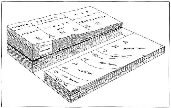
The principal historical events affecting these older beds are described as follows: After the deposition and lithification of these strata an extensive region, including northeastern Oklahoma and southeastern Kansas (including Cowley County) was arched by periodic earth movements into a broad southwestward trending nose; the sea withdrew, and the region became land; the surface beds were immediately attacked by erosion, and after a long period of time a great thickness of strata had been removed, reducing the region to a nearly level plane, thus exposing the lowermost beds (the "siliceous lime") in the higher part of the nose occupying part of northeastern Oklahoma and southeastern Kansas; the successively younger units of strata lying to the south and west formed broad bands trending in great arcs about this central area. The lower block in Figure 3 represents the surface of Oklahoma at the end of this period of erosion.
Practically the entire region was again submerged, and the Chattanooga shale, the Mississippian limestone, and finally the Pennsylvanian and Permian sediments, were deposited over and above the eroded edges of these strata. It is thus apparent that wells drilled through the Chattanooga shale and overlying beds will encounter beneath the Chattanooga shale beds of different ages in different wells, the particular beds depending upon the location. According to White's map the rocks lying beneath the Chattanooga shale strike slightly west of north and dip gently southwest at the north boundary of Oklahoma, where it coincides with the south boundary of Cowley County, so that a well drilled in R. 8 E., in the southern part of the county, should pass from the Chattanooga shale immediately into the "siliceous lime"; wells in R. 7 E. should encounter the "Burgen" sandstone beneath the Chattanooga and then pass into the "siliceous lime"; a well drilled in R. 6 E. to R. 4 E. should encounter westward successively greater amounts of the Tyner formation before entering the "Burgen" sandstone and "siliceous lime"; wells drilled in R. 3 E. should find the "Wilcox" sand immediately beneath the Chattanooga shale, below which should be the Tyner formation, then the "Burgen" sandstone and the "siliceous lime." Differentiation of the several formations recognized by White in the area adjacent to Cowley County on the south is not possible on the basis of driller's records of wells drilled in Cowley County, but a study of well cuttings from these beds by workers familiar with these rocks throughout the region to the south should permit the correct projection of White's findings northward into Kansas. Inasmuch as many of these beds yield oil, it is highly important that their identification be made to prevent abandoning wells before all possibly oil-yielding beds have been tested. Oil is produced in this region from the rocks identified by White as Arbuckle limestone, Tyner formation, and "Wilcox" sand, and so a well that is drilled below the Mississippian should be continued until these strata are penetrated. On the basis of an arbitrary projection of White's mapping northward into Kansas, it appears that many wells in Cowley County reported to have tested the "Wilcox" sand and "siliceous lime" were actually abandoned a short distance above these beds, because many wells in the western part of the county, as well as elsewhere, have been abandoned after penetrating only a few feet of strata beneath the Chattanooga shale.
Only two wells in Cowley County are reported to have penetrated the entire thickness of these beds and entered the Pre-Cambrian rocks that form the basement upon which the Cambrian and later sediments rest. These are the Smith No. 1 well of the Doric Oil Company, near Dexter, in the northwest corner of the SE NW, sec. 18, T. 33 S., R. 7 E., and the Eckhart No. 1 well of the Phillips Petroleum Company, in the center of the SW, sec. 9, T. 35 S., R. 6 E. The Cambrian and Ordovician beds as reported in the Smith well have a total thickness of 920 feet, and in the Eckhart well of 1,050 feet. The record of the Eckhart well shows the lowermost 500 feet to consist of thick beds of limestone with a few beds of sandstone; in the succeeding 250 feet thick beds of sandstone predominate; and in the uppermost 300 feet thick beds of limestone are interbedded with relatively thin beds of shale and some sandstone. Throughout the series the sandstone beds, and in places the limestone beds, carry an abundance of water that is strongly mineralized and emits a characteristic sulphurous odor. In the Doric well the uppermost 55 feet is reported to be sandstone and the remaining 865 feet sandy limestone.
White correlates the lowermost beds of this series of strata with the Arbuckle limestone of southern Oklahoma, and says that as revealed from well cuttings they consist "of medium or fine crystalline dolomitic siliceous limestone. After boiling in acid the residue will consist largely of quartz fragments, with an occasional quartz crystal. True sand grains are seldom found in average well samples, although the formation is known to contain some thin beds of sand." He states that these characteristics are persistent throughout an extensive region. The formation reaches a maximum thickness of 1,500 feet in northern Oklahoma. It is commonly called the "siliceous lime."
Several formations overlying the "siliceous lime" in regions where they have not been removed by erosion were recognized by White. According to his map at least the "Burgen" sandstone, Tyner formation, and "Wilcox" sand should be present in Cowley County. The "Burgen" is described as a tightly cemented and glassy white sandstone, in which the individual grains are "a heterogeneous mixture of very large and very small rounded grains with etched surfaces, with enough angular grains of various sizes thrown in to make it a good mixture." It is recognized by these characteristics and by its stratigraphic position above the horizon of the Arbuckle limestone, and in parts of Oklahoma by its position beneath the Tyner, which is composed of green sandy shale, thin beds of sandstone, some sandy dolomite, and thin beds of red shale near the middle. The dolomitic character of the lower beds is said to become more pronounced northwestward from Tulsa, Okla. The "Wilcox" sand, overlying the beds identified by White as Tyner in western Kay County, Oklahoma, which is adjacent to Cowley County on the south, is described as a much more uniform fine-grained sand than the "Burgen" sand. It is characterized by a high percentage of fine angular grains accompanied by a few large, rounded, etched grains and more small rounded grains. The characteristics of the "Wilcox" and "Burgen" do not differ widely enough to afford positive identification from single samples.
White describes a group of beds consisting of brown and gray sandy dolomitic limestones interstratified with some green shale and thin beds of sandstone lying above the "Wilcox" sand, in the uppermost part of the rocks which he identifies as Simpson formation in the extreme western part of Kay County, Oklahoma, several miles west of the southwest corner of Cowley County. It may be that these beds do not extend far enough east to be present in Cowley County. Above these beds, but present farther west and south, are rocks identified by White as the Viola limestone and Sylvan shale, both of Ordovician age, which still farther west and north are overlain by rocks that he correlates with the Hunton limestone of Silurian and Devonian age. A projection of White's mapping northward indicates that these higher rocks, if ever present, were removed by erosion from the Cowley County area prior to the submergence of the region in Chattanooga time, but owing to the lack of information concerning these beds in Cowley County it cannot be said that they are not present.
A thin veneer of sand of irregular thickness and patchy distribution is described as occurring upon the old erosion surface that lies on these rocks buried and preserved beneath the Chattanooga shale. Because of the sub circular shape and other characters of the sand bodies at this horizon, White believes that this sand was deposited by winds, the source of the material being the "Burgen" sandstone, Tyner formation, and "Wilcox" sand. It is known to the drillers as the Misener sand, and is correlated by White with the Sylamore sandstone member of the Chattanooga shale of eastern Oklahoma and Arkansas.
Figure 3 represents the facts presented above in a diagrammatic manner. The lower part of the figure shows a block or segment of the earth's crust that includes northeastern Oklahoma, indicating the rocks that occupied the surface at the end of the erosion period that immediately preceded the deposition of the Chattanooga shale. The reader must imagine that the Permian, Pennsylvanian and Mississippian beds that now cover this region have been cut away, exposing the underlying Ordovician strata. The block has been cut vertically along the Oklahoma-Kansas boundary, the cut edge revealing a vertical cross section of the strata. In the northern block the beds overlying the Ordovician rocks have not been removed, so that the complete section of strata is represented as it exists to-day.
Figure 3--Block diagram showing Cowley County and adjacent region looking north. Block is cut along Kansas-Oklahoma line. All beds from Chattanooga shale upward have been stripped from the Oklahoma area, exposing the Pre-Chattanooga surface. The Kansas part represents the present surface and stratigraphic section. The Pre-Chattanooga formations are based on the correlations of Luther White. Well A penetrates "Wilcox" sand immediately beneath the Chattanooga shale; well B enters rocks correlated by White with the Tyner formation; and well C passes directly into the "siliceous lime" (Arbuckle limestone according to White). [A larger PDF version of this figure is available.]
Mississippian (?) Rocks
Chattanooga Shale
[Note: The United States Geological Survey classes the Chattanooga shale as Devonian (?)]
Black carbonaceous fissile shale ranging between 50 and 100 feet in thickness, lying unconformably on older strata and locally entirely absent, composes the Chattanooga shale of Mississippian age. This shale unit is exceptionally widespread throughout Oklahoma and Kansas and is in general well known to the drillers. Its upper surface ranges in depth beneath the surface from 3,150 feet in the northeastern part of Cowley County to about 3,700 feet in the southwestern part. It is in general readily recognized in wells by its position beneath the Mississippian limestone and its softness arid black color as contrasted with the hard gray beds above it. The Chattanooga shale appears to be absent in parts of Cowley County. Two deep wells drilled near Dexter failed to report it, although others near by reported it in normal thickness. The log of a well drilled 8 miles northeast of Dexter, another 11 miles southeast of Dexter, and three wells 1, 4 and 5 miles northeast of Cambridge do not record this shale. However, it is reported as being 70 feet thick in a well drilled 4 miles northwest of Cambridge and 85 feet thick in a well drilled near the county boundary 8 miles east of Cambridge. Its absence in certain localities may mean either that these places stood as islands in the Chattanooga sea and so were never covered by shale, or that the shale was spread over the entire region but locally removed by erosion prior to the deposition of the overlying Mississippian beds. The fact that after the deposition of the Chattanooga shale it was eroded to an uneven surface and in places entirely removed in northeastern Oklahoma, and its abrupt disappearance in wells at Dexter located near other wells that found the shale present with normal thickness, suggest that the second alternative is the true explanation of its absence in parts of Cowley County.
Mississippian Limestone
A series of beds in Kansas, composed largely of limestone of Mississippian age, constitute probably the most widely known buried rocks in this region--the "Mississippi lime" of the drillers and operators. As a unit it is readily traceable by means of well records throughout an extensive part of the midcontinent region. In Cowley County it ranges in thickness from 225 to 400 feet and lies at depths ranging from 2,850 feet in the northeastern part of the county to 3,350 feet in the southwestern part. It is noticeably thinner over structural "highs" and thicker over the "lows."
The Mississippian rocks crop out in northeastern Oklahoma, where they consist of a thick series of limestone and shale, in which the limestone beds make up the larger part of the total thickness. The strata there are divided into a number of formations, of which the Boone limestone, consisting of thick beds of cherty limestone, is much the thickest and probably the most widespread. In Cowley County and elsewhere in the adjacent region the Mississippian beds are reported by drillers as being composed largely of light gray to dark gray cherty limestone, probably representing in large part the Boone. A number of logs of wells drilled in Cowley County report beds of sandstone and shale interbedded with limestone in the upper part of the Mississippian strata. These beds may represent Mississippian formations above the Boone or may be beds within the Boone that do not maintain the most common characteristics of that formation. A similar condition is reported in the lower part of the Mississippian rocks in a number of wells drilled in Cowley County. Beds of green and dark shale interbedded with limestone are shown in these rocks in wells drilled in the central part of the county. A few well logs report red rock a short distance above the base of the Mississippian beds, and one well reports "chat" at this horizon. It is not known whether these lower shaly beds are equivalent to cherty limestone beds of the lower part of the Boone in northeastern Oklahoma or whether they are older. The entire unit between the Cherokee shale above and the Chattanooga shale below is commonly known as the "Mississippi lime." In many wells the entire thickness is reported as limestone. In most localities the "Mississippi lime" appears to rest conformably upon the Chattanooga shale, but in northeastern Cowley County the Chattanooga appears to be absent, and the Mississippian limestone beds lie directly upon Ordovician rocks. The upper surface of the "Mississippi lime" is irregular, owing to erosion throughout a long period prior to the deposition of the overlying Cherokee shale.
Pennsylvanian Rocks
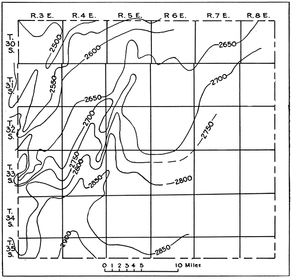
Interbedded limestone and shale and minor amounts of sandstone, having an aggregate thickness ranging from 1,200 to 1,800 feet, make up the Pennsylvanian rock section in Cowley County. In general the strata are characterized by a shale unit (Cherokee shale) in the lowermost part, overlain by a thick unit of interbedded limestone and shale (Marmaton and Kansas City groups) in which the limestone beds form the larger part. [Note: The Marmaton group of the State Geological Survey of Kansas is divided by the United States Geological Survey into two, called Henrietta and Pleasanton, which are not separable in the well logs in Cowley County.] Over this lies a thick unit composed largely of shale, but containing some sandstone near its middle (Lansing group and lower part of Douglas group), above which is a unit composed of interbedded limestone and shale (upper part of Douglas group and Shawnee group) constituting the uppermost part of the buried rocks. The Wabaunsee group overlies the strata just described and constitutes the uppermost group of the Pennsylvanian system. The beds of the Wabaunsee group crop out in Cowley County, and so its several parts are described under the heading "Surface rocks." The total thickness of the Pennsylvanian increases from northwest to southeast across Cowley County. This southeastward thickening continues across northern Oklahoma (Levorsen, 1927). In Cowley County the change in thickness is comparatively irregular, as shown in Figure 4. The system is thin over the more pronounced anticlines and thicker on the synclines. The upper part of the Pennsylvanian beds is not present in the eastern part of the county, but the continuation of the divergence in that direction is indicated by a study of the interval between the Oread limestone and the base of the Cherokee, which comprises roughly the lower half of the Pennsylvanian. The thickness of this unit at the northwest corner of the county is 600 feet less than at the southeast corner, an average change of 14 feet to the mile. Reference to Figure 4 will show that in R. 4 E. the northward convergence of the entire Pennsylvanian system averages 12 feet to the mile. The maximum rate, which would be in a northwest rather than true north direction, would be somewhat greater than 12 feet to the mile.
Figure 4--Map of Cowley County. The lines show thickness of the Pennsylvanian rocks.
Cherokee Shale
Overlying the irregular surface of the Mississippian limestone is a relatively thick unit of strata composed largely of dark gray shale beds known as the Cherokee shale. In Cowley County it ranges in thickness from a little less than 300 feet in the eastern part to a little less than 125 feet in the northwestern part. The southeastward thickening is in general fairly uniform, but local variations, with notable small thicknesses over structurally high parts of the "Mississippi lime," are noteworthy. The Cherokee shale is composed predominantly of beds of shale, but locally beds of sandstone are present, and because they serve as reservoirs for the accumulation of oil and gas in numerous localities in the county as well as elsewhere in the region, they are of great economic importance. In general the sandstone is more abundant in the western half of the county than in the eastern half. Even in the western half the sandstone beds are lenticular, being entirely absent in many localities. Thin beds of "red rock" are commonly present in the lower part of the Cherokee shale, but constitute only a very minor part of its total thickness in most places. Similar beds are present in the upper part in certain areas. The "red rock" reaches a maximum total thickness of 75 feet and is particularly abundant in the south-central part of the county. There appears to be no definite relation between the occurrence of sandstone lenses and that of the "red rock," nor does the distribution of the "red rock" appear to bear any definite relation to the structurally high areas in the Mississippian limestone.
Many well logs report "chat" from 1 to 50 feet thick immediately above the "Mississippi lime." This material is believed to be weathered rock fragments dislodged from the Mississippian strata during the period of erosion that followed the Mississippian sedimentation, the debris being buried later by the overlying shale beds. Its occurrence is patchy, but it increases in thickness and in number of occurrences westward toward the buried "granite ridge" that crosses the northwestern part of Cowley County. The "chat" is composed largely of rounded pebbles and sand grains of chert, with lesser amounts of other material. Because of crushing by the drill, it commonly comes from wells in sharply angular fragments of chert, resembling the chat used in road construction. It serves as a reservoir for oil and gas in some localities. It is herein described with rocks of Pennsylvanian age, because it is probably a product of weathering of Mississippian strata in early Pennsylvanian time. It may be in part residual and in part transported. The Mississippian beds formed the surface of a land mass and were subjected to erosion for a long time after the beginning of Pennsylvanian time, while the Pennsylvanian sea was spreading northwestward from the eastern Oklahoma region. The sea probably did not invade Cowley County until a great thickness of sediments had been deposited in eastern Oklahoma and Kansas (McCoy, 1921). It was during this early Pennsylvanian time that the "chat" of Cowley County is believed to have been formed.
Marmaton and Kansas City Groups
[Note: The term Marmaton group, as used in this report, includes the Henrietta and Pleasanton groups of the United States Geological Survey.]
Interbedded limestone and shale occupy an interval of about 500 feet immediately above the Cherokee shale and are believed to belong to the Marmaton and Kansas City groups of eastern Kansas. These groups are readily divisible into a number of formations at their outcrops in eastern Kansas, and many members and formations are traceable by means of well records for long distances westward from their outcrops, but in Cowley County the distinction between the several subdivisions, as well as between the groups themselves, can not always readily be made from well records. The two groups are accordingly treated herein as a unit. The unit varies somewhat in total thickness in the county, being thickest in the southeastern part and thinning toward the north and west. In the northern part of the county the upper part--the Kansas City group--is composed largely of gray limestone and is commonly recorded as solid limestone a little more than 200 feet thick. Sandstone beds make their appearance in the upper part of the unit 10 to 15 miles south of the northern boundary of the county and with some interbedded shale increase in thickness southward, until in the southern part of the county a large part of the upper two-thirds of the Marmaton and Kansas City groups is occupied by shale and sandstone. Limestone and shale in relatively thin beds form the lower third of the unit. Beds at numerous horizons in these groups yield oil and gas in Cowley County, but the beds of sandstone in the uppermost part of the Kansas City group, known as the Layton sand, are probably the most productive.
Lansing Group
The Lansing group includes beds about 400 feet in total thickness succeeding the Kansas City group. In Cowley County it consists predominantly of shale, with minor amounts of sandstone and limestone. A relatively thick zone composed almost entirely of sandstone occupies the uppermost part of the group and is widespread throughout the county. This sandstone zone is a prolific water producer, but yields oil in one or two localities. The position of the boundaries of the Lansing group as shown on the correlation chart (Pl. II) is open to some question, but the general horizon of the group is believed to be correctly placed.
Douglas Group
About 350 feet of shale, sandstone, red rock and limestone make up the Douglas group as correlated by well logs. In the uppermost part of the group several thin limestone beds underlain by interbedded red rock and shale are believed to represent the Oread limestone, the uppermost formation of the Douglas group as described from exposures in eastern Kansas. The zone containing the red beds is widespread in southern Kansas and northern Oklahoma, and inasmuch as there are no other red beds in the stratigraphic succession several hundred feet above and below this zone, it forms an admirable marker for correlation by means of well logs.
Shawnee Group
Above the Oread limestone is a series of interbedded limestone and shale, with a few beds of sandstone, in all about 650 feet thick, that contains a much greater percentage of limestone than the underlying Douglas and Lansing groups. In eastern Kansas this group includes a number of formations, among them the Lecompton, Deer Creek and Topeka limestones, but these formations are difficulty differentiated in well records in Cowley County. The lower half of the group contains more limestone than the upper half.
Prev Page--Geography || Next Page--Stratigraphy, Pennsylvanian
Kansas Geological Survey, Geology
Placed on web Jan. 5, 2016; originally published May 15, 1929.
Comments to webadmin@kgs.ku.edu
The URL for this page is http://www.kgs.ku.edu/Publications/Bulletins/12/04_strat.html