![]()
Prev Page--Stratigraphy, Permian || Next Page--Structure
Stratigraphy, continued
Exposed Rocks, continued
Tertiary (?) System
Pliocene (?) Series
Gravel
Deposits of gravel composed largely of chert, as much as 19 feet and possibly more in thickness, are present at the surface in parts of Cowley County, at altitudes above the stream beds ranging between 150 and a little more than 200 feet. No particular study was made of the gravel deposits, and they were not mapped, but were noted wherever seen in the course of other field work. Accordingly there are, no doubt, many localities containing gravel deposits that were not seen. A deposit forming the upland northeast from Floral has the highest altitude of the deposits noted, being a little more than 1,300 feet above sea level (Altitudes based on the Burden topographic map of the U. S. Geological Survey). The thickest deposit seen has a maximum thickness of 19 feet. It is exposed in a working gravel pit northeast of Silverdale, in the NW, sec. 21, T. 34 S., R. 5 E. The extent of this deposit was not determined, but it is known to occupy much of the S2, sec. 16, the SE, sec. 17, the NE and a small part of the SE, sec. 20, most of the W2, sec. 21, a small part of the NW, sec. 28, and the NE, sec. 29. It is estimated that 95 per cent of the gravel is made up of fragments of chert and the remaining 5 per cent is limestone. Fine materials--sand, silt, and clay-fill the spaces between the gravel particles and bind the gravel together so firmly that it will stand in vertical walls on the pit face. (See Pl. VIII.) Most of the gravel particles are less than 1 1/2 inches in diameter, although a small percentage are as much as 5 inches; the prevailing size appeared to be about 1 inch. Most of the particles are subangular; the original shapes are in large part retained, but the corners and edges are rounded; a small percentage of the particles are well rounded. Some fragments contain well-preserved fossils. The pebbles have a glazed surface of tan to reddish-brown color. This gravel deposit is estimated from the topographic map to lie at its highest point a little more than 200 feet above the present stream bed of Grouse creek. It was being actively worked at the time of the examination.
Plate VIII--Upper: Gravel pit 3 miles northeast of Silverdale. Lower: Loading gravel from pit 3 miles northeast of Silverdale.
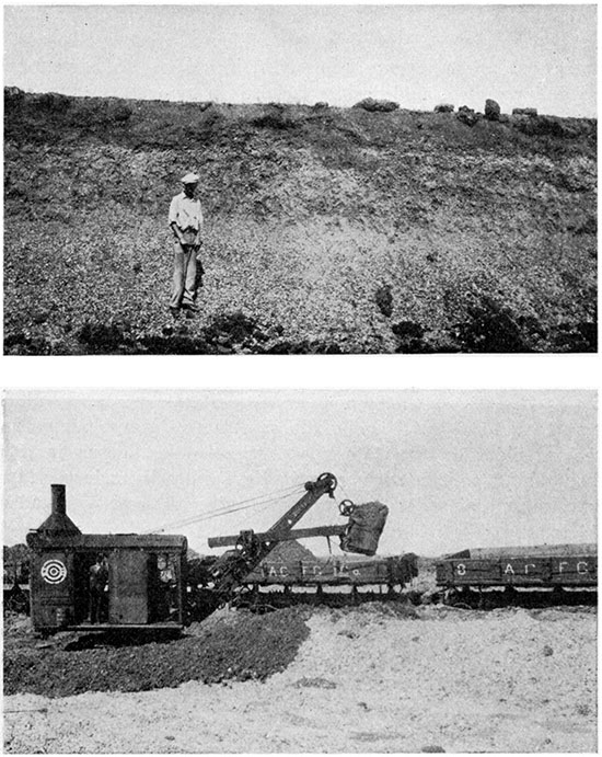
A gravel deposit similar in character to that described above surrounds the center of sec. 32, T. 34 S., R. 5 E., immediately north of Silverdale. It appears to be much thinner and occurs at an altitude about 50 feet lower than the other deposit. A steam shovel, cars, washer, and tipple at the locality had stood idle for a year or more at the time of the field examination of the area, but it is reported that this gravel deposit was being worked in 1927.
Gravel occurs along Walnut river at heights ranging from less than 50 feet to more than 100 feet above the river and is believed to represent deposits laid down much later than the deposits at Silverdale. However, gravel was seen at higher altitudes in a few localities bordering Walnut river, and it is believed that many other similar deposits are probably present. One of those seen occurs at an altitude of a little above 1,200 feet in the SE, sec. 8 and the SW, sec. 19, T. 33 S., R. 4 E., 3 miles south of Winfield, and another surrounds the corner common to secs. 25, 26, 35 and 36, T. 30 S., R. 3 E., lying a little above 1,250 feet. Several deposits of gravel were seen on the north side of Dutch creek in the north-central part of the county, some lying high above the stream and probably representing deposits equivalent in time of deposition with those at Silverdale and others occurring at lower altitudes and deposited at a much later date. Gravel occupies the surface of an area of considerable extent northeast of Floral at an altitude of a little more than 1,300 feet; gravel was seen at an altitude of 1,250 feet about 1 1/2 miles southwest of Floral, in the northern part of sec. 24, T. 31 S., R. 4 E., and at a somewhat lower altitude a mile farther southwest, in section 26.
What has been commercially one of the most important gravel deposits in southern Kansas occurs largely in Butler County, but extends into Cowley County, bordering the Winfield-Augusta highway in the NW, sec. 4, and the NE, sec. 5, T. 30 S., R. 4 E. The gravel caps the upland and lies at an altitude of 1,200 to a little more than 1,250 feet. One of the most active gravel mining and washing plants in the state was developing this deposit in 1926, about half a mile north of the Cowley County boundary. More gravel occurs at a little above 1,250 feet on the county boundary 1 1/2 miles east of this deposit.
Outside of Cowley County extensive gravel deposits border the bottoms of Walnut river and its tributaries in southern Butler County, particularly at Leon and on both sides of Little Walnut creek from 2 to 6 miles south of Haverhill. Other deposits were seen north of El Dorado, in central Butler County; in the vicinity of Cottonwood Falls, Chase County, bordering South Fork and Cottonwood river; and in Lyon County near Emporia and Americus, on the divide between Neosho and Cottonwood rivers. There are also extensive deposits on the uplands in Anderson, Osage and other counties in east-central Kansas. In fact, deposits of chert gravel, in general similar to those described as occurring in Cowley County, are extensively distributed along the streams but far above their present flood plains throughout much of eastern Kansas.
Origin. The nature of the material and the location of the deposits demonstrate that these gravel deposits were laid down by streams flowing at higher positions than those of the present day. The fact that the individual pebbles have retained in the main their original shapes, modified only by rounded edges and corners, indicates that they have been transported only moderate distances. Fossils occurring in individual particles common to the rocks in the lower part of the Permian series have been identified in many localities, the following species being abundant, according to Wooster (1914):
| Productus semireticulatus | Athyris (Composita) subtilita | Fusulina cylindrica | Various species of cup corals, crinoids and lace corals. |
These fossils and the type of material that makes up the gravel deposits appear to prove that they were derived largely from the chert-bearing Florence flint and Wreford limestone. Most of the streams carrying the material flowed eastward, but those in Cowley County flowed southward and southwest ward in general as they do to-day, except that they flowed at relatively higher altitudes.
Age. Very little information concerning the age of the grave! deposits was obtained in Cowley County, but fortunately similar deposits that occur in the northeastern third of the state have been studied in some detail with reference to age of deposition by Todd (1918a, 1918b). This author recognizes three main types of stream deposits in the region of Kansas river--higher-level chert gravel, lower-level chert gravel, and drift-filled channels. It appears probable that Todd's higher-level chert gravel may be correlated with the higher gravel of Cowley County and other localities in eastern Kansas. He describes deposits as forming terraces and capping upland surfaces, bordering Kansas river, Mill Creek, and other eastward-flowing streams and occurring 125 to 150 feet higher than the present stream levels. He states that these higher gravel deposits are composed largely of chert fragments that are easily traced to their source in the chert-bearing limestone formations in the lower part of the Permian series. They contain no northern erratics, although such rock types were seen lying upon the gravel beds at a number of localities. Inasmuch as it is well established that the material containing the northern erratics common to northeastern Kansas was brought there by the continental ice sheets that moved southward into this region during the Kansan stage of the Pleistocene epoch, the finding of none of this material in the gravel and its occurrence in the deposits overlying the gravel beds indicate a Pre-Kansan age for the gravel, and Todd believes that they are Pre-Pleistocene, having been deposited in very late Pliocene time. On this basis it may be tentatively assumed that the gravel deposits that occur at altitudes between about 1,200 and 1,300 feet in Cowley County, such as those near Silverdale and Floral and north of Rock, were deposited in late Pliocene time by streams such as Walnut river, Grouse creek, and others flowing 175 to 225 feet above their present levels but in general following the same courses as they occupy at present. This means that about 1,000,000 years has elapsed since the higher gravel deposits were laid down in Cowley County.
Quaternary System
Gravel
Gravel deposits composed largely of chert particles occur at various levels, and apparently in no systematic levels between the position of the high gravel and the present streams. They were probably derived from the higher Pliocene (?) gravels, reworked and redeposited as the streams haltingly cut downward during Pleistocene time, though some of the higher deposits may be of Pre-Pleistocene age. The deposits here described differ little from the Pliocene (?) gravel except that they appear to contain a larger percentage of smaller particles, and the particles are somewhat less angular. Gravel of this nature has been mined for local road surfacing in the NE, sec. 4, T. 33 S., R. 4 E., a little more than a mile south of Winfield. This deposit lies at an altitude of about 1,125 feet, a little more than 50 feet above Walnut river, and is composed of somewhat finer, more rounded chert particles than the deposits at Silverdale.
Occurring at, approximately the same altitude and having the same general character as the gravel in sec. 4, T. 33 S., R. 4 E., gravel deposits were seen at a number of localities on the upland immediately west of the Walnut river bottoms, from a point west of Winfield north for 10 miles. It is probable that gravel is rather widespread in this vicinity and on northward to and beyond the northern boundary of the county. The lower gravel deposits on Dutch creek, about 3 miles southwest of Floral, also belong in this class.
Loess
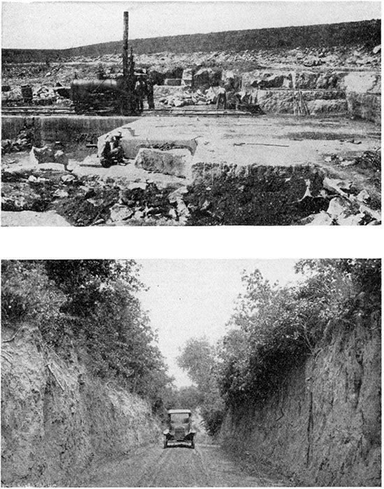
Distribution. Relatively thick deposits of loess, diminishing in thickness northeastward, occur in the southwestern part of Cowley County, at all levels between the slopes a few feet above the alluvium of the bottom lands and the highest divides. The loess ranges in thickness from a few inches to more than 25 feet; it has a reddish-brown color, stands in vertical walls 15 to 20 feet high in road cuts and stream channels, and exhibits a crude columnar structure in many exposures. Plate IX shows the loess standing in vertical embankments on each side of the road in the southern part of the county in T. 35 S., R. 4 E. Deposits of loess are exposed at a number of localities east, south and west of Arkansas City; and loess borders the Arkansas City-Joplin highway a little less than half a mile east of Walnut river and stands in vertical bluffs bordering the road at several localities a short distance farther east. It is well exposed about a mile west of Arkansas City only a few feet above the level of the Arkansas river bottom land, and it occupies much of the surface for miles southwest of the town, exposures being abundant on all roads. Thin local deposits extend northward nearly to Winfield.
Plate IX--Upper: Silverdale quarry of the Arkansas City Sand and Gravel Company, 1 1/2 miles northeast of Silverdale. Lower: Road cut in loess in T. 35 S., R. 4 E., in southern part of Cowley County.
Origin. Inasmuch as the loess in Cowley County is composed of very fine homogeneous material occurring at all altitudes mantling the surface, and stands in vertical walls exhibiting a columnar structure, a characteristic feature of many deposits of loess elsewhere, it is thought to have been very largely deposited by wind and to be a true loess. Its reddish-brown color, its diminishing thickness northeastward in Cowley County, and the fact that the prevailing winds of this region are northerly, indicate that the "Red Beds" of Oklahoma constitute its chief source, although other strata, particularly Permian beds beneath the "Red Beds," probably have furnished a part of the material.
Age. As shown by the discussion of the chert gravel deposits, it appears probable that the streams of Cowley County were flowing at levels about 200 feet above their present positions at the beginning of Pleistocene time, and that the process of lowering their channel beds to the present levels occupied all of Pleistocene time and part of Recent time. The alluvium forming the bottom lands is regarded as having accumulated in Recent time. The fact that the loess occurs well down in the valley trenches, thickly covering the slopes to levels within a few feet of the bottom lands, indicates that much of it accumulated not long prior to Recent time, probably late in the Pleistocene, after much of the down-cutting of the stream courses had been accomplished. Very likely the deposition was relatively slow and extended throughout a long period, and probably is still continuing but with diminished intensity.
Alluvium
Alluvium having a known maximum thickness of 55 feet occupies the lower parts of the valleys of all the principal streams of Cowley County. The material consists of clay, silt, sand and gravel deposited during flood periods of the streams, in Recent geologic time, since the streams have reached their present levels and have been engaged in widening their valley bottoms. The alluvial plain of the Arkansas has a maximum width of 3 miles, and that of Walnut river 2 miles. Grouse, Silver, Dutch, Timber, and Rock creeks have also developed fairly extensive bottom lands, but their widths exceed half a mile in only a few localities .: The extent of the alluvium bordering the principal streams of the county is shown on the geologic map (Pl. I). Surface exposures and drilled wells indicate that the alluvium along Arkansas river is composed largely of quartz sand, but that the alluvium bordering other streams contains a large pro-portion of clay and silt with very little quartz sand. Logs of wells drilled for oil in the Arkansas river bottom in the extreme western part of the county record the alluvium as being about 55 feet thick and composed largely of quartz sand with some gravel, all except the uppermost few feet being water bearing. According to the city water superintendent the water wells at Arkansas City, in the alluvium of Arkansas river, penetrated 10 feet of loose sand, below which is 15 feet of sharp water-bearing sand, and next below is 20 feet of water-bearing sand and gravel, the individual particles ranging between fine sand and grains the size of peas. Core-drilled holes recently driven into the alluvium of Walnut valley a few miles southwest of Rock are reported to have penetrated about 35 feet of alluvium lying above the bedrock (Joe Bailey, The Trees Oil Co., personal communication). The uppermost 25 to 30 feet was composed almost entirely of black clay and silt, and the lowermost 7 to 8 feet of gravel with pebbles ranging between one-fourth and one-half inch in diameter. The alluvium bordering most of the lesser streams of Cowley County is similar to that of Walnut river.
This difference in the nature of the material in the alluvium of the Arkansas and Walnut valleys is readily accounted for by comparing the surface materials of their drainage basins. The area drained by Walnut river and the smaller streams of Cowley County is underlain at the surface by beds of limestone and shale containing only a very small amount of sandstone. The material eroded from these rocks and transported to the river bottoms consists of fine clay and silt particles with minor amounts of coarser material. Arkansas river, however, flows through an extensive region several miles west of Cowley County that is covered with wind-blown sand and underlain by rocks composed largely of sand (the Dakota sandstone), and the alluvium that occupies its valley reflects the character of these rocks, which have furnished much of the material of which it is composed. The lack of coarse material in the alluvium of the Walnut valley is of no little economic importance, because the compact material yields only a small amount of water, insufficient to supply towns the size of Winfield. In contrast, the quartz sand of the alluvium of the Arkansas valley is very porous and readily yields abundant flows of water.
Dune Sand
Patches of wind-blown quartz sand occur on the upland between Arkansas and Walnut rivers a few miles east of Arkansas City and thicker and more extensive deposits are present west and northwest of Arkansas City on the uplands near the Arkansas. Although these sand deposits were not examined in detail, the abundance of sand in the Arkansas valley and the northerly direction of the prevailing winds suggest that the sand is at least in part derived from the river bottom lands.
Oil-and-gas-producing Rocks
There are nearly 30 localities in Cowley County where oil or gas or both have been found, and the beds that contain these substances are widely, distributed vertically through the stratigraphic succession. So far as number of producing localities is concerned, the most important strata are probably the numerous sandstone beds in the Admire shale, sandstone and sandy limestone beds in the upper part of the Kansas City group, and sandstone beds in the lower part of the Cherokee shale. The last-named beds, known as the Bartlesville sand, have produced by far the greatest amount of oil in Cowley County. The lowest rocks that produce oil or gas in the county are reported as sands and porous limestones in the uppermost part of the Ordovician rocks. The producing beds of the Ordovician probably do not represent the same horizon in all localities, but no attempt has been made in connection with this work to correlate these deeper-lying rocks, nor is it positively known in what part of the Ordovician system they occur.
Rocks of probable Ordovician age produce oil in the State School, Slick-Carson, and Graham pools (refer to Plate XI for field location). The upper part of the "Mississippi lime" contains porous beds that produce relatively small amounts of oil in the Dexter, Otto, Countryman, and Mahannah fields. Fragmental material composed largely of chert pebbles and sand grains is distributed in discontinuous patches on the surface of the "Mississippi lime." The material is locally called "chat." It produces oil in a well drilled in sec. 5, T. 34 S., R. 3 E. Beds of sandstone in the lower part of the Cherokee shale (the Bartlesville sand) are abundant producers of oil and gas. The producing sand of the Rainbow Bend field belongs in this zone. It lies immediately above the "chat" in parts of the field and in contact with the "Mississippi lime" where the "chat" is not present. In other localities the Bartlesville sand is separated from the Mississippian limestone by 50 to 100 feet of shale and commonly produces both oil and gas. In Cowley County this sand is productive in the Eastman, Rock, Winfield, and Clarke fields; in one well in the Slick-Carson field; in a small part of sec. 30, T. 30 S., R. 4 E., 2 miles southwest of Rock; in a small part of sec. 6, T. 30 S., R. 6 E.; and in parts of secs. 16, 17, 20, and 21, T. 34 S., R. 3 E. A bed of sandstone near the middle of the Cherokee shale yields oil in the Empire-McCormick pool. Oil is produced from a bed near the middle of the Marmaton group in the Olsen pool; and sandstone in the upper part of the Marmaton or near the contact of the Marmaton and Kansas City groups contains oil in wells in the Biddle pool and in one well in the Peacock pool. The sand near the contact of the Marmaton and Kansas City groups produces oil and gas in the State School pool. The Kansas City group yields gas and oil abundantly in several localities. Production from the uppermost part of the group is the more widespread, although other parts of the group are productive in several localities. Oil is found in the upper part of the Kansas City group in the Biddle, Elrod, Slick-Carson, Countryman, and Graham pools and in sec. 28, T. 31 S., R. 4 E.; oil and gas in the Winfield and State School pools; and only gas in the Grand Summit and Empire-McCormick pools. A sandy zone about 100 feet below the top of the group produces a little oil in the Slick-Carson pool and has yielded gas in the Falls City pool. A similar zone about 200 feet beneath the top of the group yields oil in the Rockwell pool, oil and gas at Grand Summit, and gas in the Empire-McCormick field. Sandstone in the lower part of the Lansing group has produced gas in the Falls City field; a similar bed near the middle of the Lansing group has produced gas in the Olsen pool; and a thick sandstone in the uppermost part of the group that is widespread and contains water in most localities yields oil in the Udall pool, gas in the Falls City field, gas in one well in sec. 14, T. 34 S., R. 4 E., and gas in sec. 4, T. 35 S., R. 4 E. It is this upper sand that has produced the abundant flow of oil in the Churchill pool, adjacent to Cowley County on the west.
Oil occurs in the Udall pool in sand in the upper part of the Douglas group, a short distance beneath the Oread limestone, and sandstone at this stratigraphic position contained gas in the Floral field. Sandstone occurring about 150 feet above the Oread limestone in the lower part of the Shawnee group and known as the "1400 foot" sand produces oil in the Peacock and Winfield pools; sand at the same horizon contained gas in the Dexter and Otto fields. The upper part of the Shawnee group produced gas in sec. 16, T. 34 S., R. 3 E. Gas-producing sand lenses occur in the Admire shale; they have yielded gas abundantly throughout extensive areas in the Winfield district, in several localities in the Arkansas City district, in the Dexter, Otto, and Countryman fields, and in one well in sec. 33, T. 33 S., R.3 E.
One prevailing characteristic of the oil- and gas-producing beds is their lenticularity. The numerous beds of gas-producing sandstone in the Admire shale appear not to be clearly defined beds continuous over a large area, but rather to form a sandy zone in tho shale formation, composed of interfingering lens-shaped beds of sandy shale and sandstone, each 5 to 20 feet thick. A single bed may continue throughout several square miles, and its outline in plan may commonly be more or less equidimensional--that is, it does not present a narrow, elongated pattern such as that of many of the producing sands in the Cherokee shale, which are typically developed in Greenwood County.
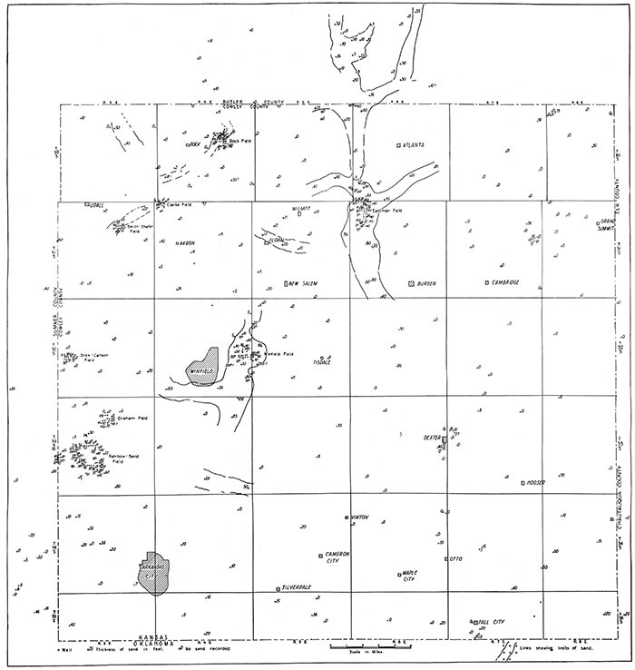
The sandstone in the uppermost part of the Lansing group is the thickest and most widespread sandstone unit in the stratigraphic section. It is not uncommonly more than 100 feet thick and is reported in the logs of wells in all the principal fields in the county. In most localities it produces a "hole full of water." Contrasted with this sand are the sands at the "Bartlesville horizon" in the lower part of the Cherokee shale, either at its base and lying directly upon "Mississippi lime" or slightly higher and separated from the "Mississippi lime" by 50 feet or less of "chat" or by 25 to 100 feet of shale or "chat" and shale. Sand bodies at this general horizon range between 20 and 75 feet in thickness and are continuous for several miles, but terminate comparatively abruptly in directions at approximate right angles to the direction of elongation. The characteristic pattern formed by the distribution of these sand deposits consists of somewhat irregularly trending bodies several times longer than their widths. The producing sands in the Eastman and Rock pools are typical examples of these deposits. The areal shape of the sand body in the Rainbow Bend pool is more nearly circular, with a lobe trending southeastward. Plate X is a sketch map of the county showing the distribution of sand at this horizon and the thicknesses of the sand as reported in logs of drilled wells that penetrated the stratigraphic horizon of the sandstone but encountered no sand.
Plate X--Sketch map showing distribution and thickness of sand at "the Bartlesville horizon" in Cowley County. [A larger PDF version of this figure is available.]
Little detailed information concerning the character of the material composing the sand bodies is available. Chunk samples from the Smith-Shafer, Winfield, and Rainbow Bend fields show the sand to be composed largely of subangular quartz grains containing a considerable percentage of clay. Some samples are slightly calcareous, and others are not. In general the sand is not extremely well sorted. A mechanical analysis of one chunk sample from the Smith-Shafer field shows a relatively wide range in the size of the material. Coal is reported to occur in the upper part of the sandstone in the Wright No.2 well, in the NE, sec. 28, T. 33 S., R. 3 E., in the eastern part of the Rainbow Bend field. Coal is said to have been found in the sand in the Smith-Shafer pool, and it is reported at this horizon in the Carlton well, near the center of sec. 10, T. 30 S., R. 3 E.
The information at hand is insufficient to indicate definitely the origin of these sand bodies. Sand bodies at this horizon in Greenwood County and southeastern Butler County have been interpreted by Cadman as being continental deposits laid down by streams (Cadman, 1927). Characteristics that would be found in a continental deposit, perhaps filled stream channels such as Cadman has described for the region immediately northeast of this county, are exhibited by the Bartlesville sand in the vicinity of the Eastman and Rock fields and to a certain extent in the Winfield field. The occurrence of coal in the sand at a few places, the presence of "red rock" at the horizon of the sand in many wells, the relatively large percentage of clay in the sand, and the angular shape of the sand grains are in harmony with this mode of origin. But in Cowley County these characteristics are not sharply enough defined to eliminate other possible modes of origin. The northeast-southwest alinement of the principal localities of thickest sand development in Cowley County is in general strike with the Mississippian surface in early Pennsylvanian time (indicated by a map representing the range in thickness of the Cherokee shale; map not reproduced here), a fact which suggests a parallelism with the shore line of the early Pennsylvanian sea and a marine origin of the sand bodies. The occurrence of coal could be accounted for by assuming it to have accumulated in nearshore swamps during times of slight regressions of the sea. The other features shown by the chunk samples are not so sharply defined but that they may represent either marine or continental deposits. In view of the nature of the occurrence of sand bodies at the Bartlesville horizon in near-by districts, the distribution of the deposits, and the other very meager data that are not definitely opposed, the present information appears to indicate a continental origin--as buried stream-channel deposits--for the sand lenses in the Eastman, Rock, and Smith-Shafer fields, the sand in sec. 30, T. 30 S., R. 4 E., and probably the sand of the Winfield pool. The data are insufficient to venture an opinion as to the origin of the sand in the Rainbow Bend field and other localities.
Sand such as that in the Lansing group would appear to be of different origin. Its widespread, sheetlike distribution and the nature of adjacent beds suggest that it was deposited in a marine body of water.
Prev Page--Stratigraphy, Permian || Next Page--Structure
Kansas Geological Survey, Geology
Placed on web Jan. 5, 2016; originally published May 15, 1929.
Comments to webadmin@kgs.ku.edu
The URL for this page is http://www.kgs.ku.edu/Publications/Bulletins/12/04_strat4.html