![]()
Prev Page--Geography || Next Page--Ground water occurrence, water table
Geology
Summary of Stratigraphy
[Note: The geologic classification and nomenclature of this report follow the usage of the State Geological Survey of Kansas as of the publication date and differ somewhat from those used by the U. S. Geological Survey.]
The rocks cropping out in Wichita and Greeley counties range in age from Late Cretaceous to Recent (Pl. 1). The oldest rocks in the area belong to the Smoky Hill chalk member of the Niobrara formation (Pl. 5A). This formation crops out only in western Greeley County along White Woman Creek. The Pierre shale, which overlies the Niobrara formation in some other areas in western Kansas, does not crop out in Wichita and Greeley counties.
Plate 5--Cretaceous and Tertiary rocks. A, Outcrop of the Smoky Hill chalk member of the Niobrara formation in sec. 28, T. 17 S., R. 42 W., Greeley County. B, Cemented bed of the Ogallala formation lying on Smoky Hill chalk in sec. 28, T. 17 S., R. 42 W., Greeley County. The contact is at the midpoint of the hammer handle.
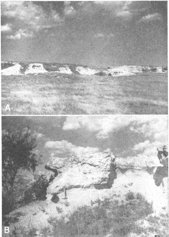
The Ogallala formation of Tertiary (Pliocene) age unconformably overlies the Niobrara throughout these two counties (Pl. 5B). The Ogallala crops out in several places, the best exposures being along Ladder and White Woman Creeks. The undissected plains surface in the area is mantled by the wind-blown silt (loess) of the Sanborn formation of late Pleistocene age. Colluvial deposits, derived mainly from loess, cover some of the slopes. A small area several miles north of Horace is mantled by dune sand. The youngest deposits in the area consist of the late Wisconsinan Bignell silt member of the Sanborn formation, dune sand, and alluvium comprising the flood plains of Ladder, White Woman, and Sand Creeks.
The character and ground-water supply of the geologic formations are described briefly in Table 2 and in more detail in the section on geologic formations and their water-bearing properties. The stratigraphic relationships of the formations are shown in the geologic cross sections in Figures 6 and 7.
Fig. 6--Geologic cross sections A-A', B-B', and D-D' through Wichita and Greeley counties. A larger version of this figure is available.
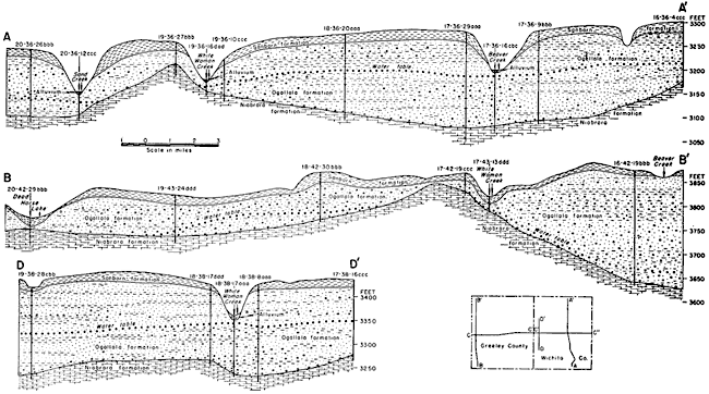
Fig. 7--Geologic cross sections C-C' and C'-C'' through Wichita and Greeley counties. A larger version of this figure is available.
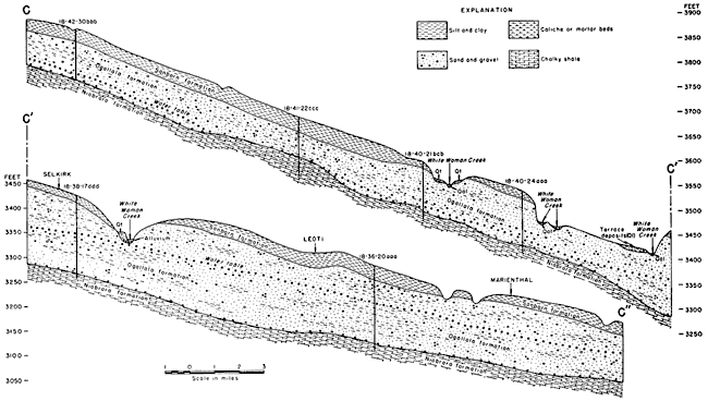
Table 2--Generalized section of the geologic formations in Wichita and Greeley Counties, Kansas.
| System | Series | Formation | Thickness, feet |
Character | Water supply |
|---|---|---|---|---|---|
| Quaternary | Pleistocene* | Alluvium | 0-30 | Gravel, sand, silt, and clay comprising stream deposits in Ladder, White Woman, and Sand creeks. | Commonly lies mainly above the water table but yields small amounts of water to wells in some areas. |
| Dune sand | 0-15± | Fine to medium sand. Mantles a very small area about 8 miles north of Horace. Dunes are stabilized by vegetation. | Lies above the water table. Area is too small to constitute an important area for ground-water recharge. | ||
| Sanborn formation (includes colluvium) |
0-30 | Light-tan silt; locally contains sand and gravel at the base. | Generally lies above the water table and yields no water to wells. | ||
| Tertiary | Pliocene | Ogallala formation | 0-245 | Sand, gravel, and silt, predominantly calcareous; unconsolidated or may be well cemented; contains beds of "Algal limestone" opalized zones, and beds of clay. | The principal aquifer in Wichita and Greeley counties; yields moderate to large supplies of water to wells in most of the area. |
| Cretaceous | Gulfian* | Niobrara formation |
100-550± | Yellow chalky limestone and light-gray to yellow chalky shale. | Yields little or no water to wells in this area. |
| *Classification of the State Geological Survey of Kansas. | |||||
Rocks Not Exposed
Directly beneath the Niobrara formation in Wichita and Greeley counties are 300 to 450 feet of beds consisting mainly of shale and limestone. Included in these beds are the Carlile shale, the Greenhorn limestone, and the Graneros shale. These formations are generally very poor aquifers and therefore will not be discussed in detail. The Dakota formation underlies the Graneros shale and is an important aquifer in some areas in Kansas. It is discussed in more detail in the section on geologic formations and their water-bearing properties.
Geomorphology
The topography in Wichita and Greeley counties has developed during Pliocene and Pleistocene times. Near the end of Cretaceous time the sea that had covered the western Kansas area during much of late Cretaceous time withdrew and the area was subjected to subaerial erosion. In early Tertiary time there was extensive uplift in the Rocky Mountain province and streams flowing eastward from this region crossed the Great Plains. While streams from the mountains were laying down extensive deposits to the north, western Kansas was being eroded. Any sediments that may have been deposited in earliest Tertiary time and varying thicknesses of Upper Cretaceous sediments were removed. In these counties the Pierre shale was completely removed and the Niobrara formation was deeply dissected in places. In Pliocene time conditions were reversed and streams from the Rockies deposited large quantities of sediments (Ogallala formation) over the High Plains of Kansas. As deposition progressed and stream valleys were filled and bedrock divides were topped, the streams shifted laterally and developed an extensive aggradational plain, which merged with the erosional plain in the Rocky Mountain region.
Near the end of the time of Ogallala deposition, the lateral shifting of stream channels due to low stream gradients and the choking of the channels with sediments may have resulted in the formation of a number of small water-table lakes. It is thought that the "Algal limestone," a distinctive hard bed of fresh-water limestone, which occurs at the top of the Ogallala formation in many localities, was precipitated in such small lakes by the fossil alga Chlorellopsis bradleyi, an alga whose living relatives are not known to precipitate calcium carbonate in running water (Elias, 1931).
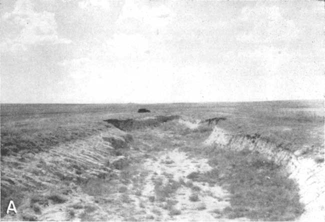
In early Pleistocene time there was uplift of the land to the west and streams in western Kansas were rejuvenated. Erosion began and streams started to cut through the Pliocene deposits. The nature of events in this area during this part of the Pleistocene is not known because Nebraskan deposits have not been found. However, it is possible that during late Kansan and early Yarmouthian time there may have been some stream deposition in the Wichita-Greeley area because deposits of the Meade formation have been identified east of this area in Scott County, along Ladder Creek. If sediments of the Meade formation were deposited in Wichita or Greeley Counties they since have been removed by erosion. During Illinoian time there may have been some deposition by streams in the area and some of the beds that have been referred to as basal Sanborn formation (Elias, 1931, p. 163) may be the Crete member of the Sanborn (Frye and Leonard, 1952). Later in the Pleistocene a mantle of wind-blown silt or loess was spread over this region. Three different loess sheets separated by two buried soils indicate that during the period of high winds there were intermediate times when winds were reduced and soils were formed. The oldest silt, the Loveland, was not deposited extensively over Wichita and Greeley counties and is generally represented only by the buried Sangamon soil which formed on it. The Peoria silt member (Pl. 6A) is widespread in the area and reaches a maximum thickness of nearly 30 feet. The Bignell or upper silt member of the Sanborn is found only in a few scattered localities (Frye and Leonard, 1952). It is separated from the Peoria silt by the Brady soil.
Plate 6A--Exposure of the Peoria silt member of the Sanborn formation where it is being cut by a tributary to Ladder Creek. View is west from highway 27 at the SE cor. sec. 5, T. 16 S., R. 40 W., Greeley County.
During Recent time the area has undergone erosion which has formed much of its present topography. Streams have cut down through loess deposits into the Ogallala formation and in western Greeley County, White Woman Creek has cut through the Ogallala into the Niobrara formation. The few small terrace remnants along Ladder, White Woman, and Sand creeks indicate that in latest Pleistocene time these streams began a new cycle of erosion. The loess mantle has been modified by the action of sheet and rill wash, and some slopes are covered by colluvial deposits, derived mainly from loess that have moved down from the uplands. These slope deposits are in places contiguous with alluvium in the valleys and the boundary between the two may be indistinct. In the upper part of the valley side slopes the colluvial deposits are generally also indistinguishable from the loess of the Sanborn formation.
Since the deposition of the loess many shallow undrained depressions have developed on the uplands in Wichita and Greeley counties. The depressions range in diameter from a few tens of feet to about half a mile. After a heavy rainfall most of them bold water until it evaporates or moves downward to the water table. Plate 4 illustrates two typical undrained depressions and the locations of many of these depressions are shown on Plate 1 as intermittent ponds. The origin of these ponds has been a subject of much speculation and controversy among geologists working in the Great Plains (Frye, 1950). The depressions in the Wichita-Greeley area have been attributed to differential deposition or erosion of loess by the wind, to compaction and reorientation of silt particles, and perhaps, to a lesser extent, to animal action.
Latest Pleistocene time has been characterized by occasional high winds, as evidenced by a small sand-dune area several miles north of Horace.
Prev Page--Geography || Next Page--Ground water occurrence, water table
Kansas Geological Survey, Geology
Placed on web Jan. 11, 2008; originally published April, 1954.
Comments to webadmin@kgs.ku.edu
The URL for this page is http://www.kgs.ku.edu/General/Geology/Wichita/04_geol.html