![]()
Prev Page--Contents || Next Page--Geography
Introduction
Purpose and Scope of the Investigation
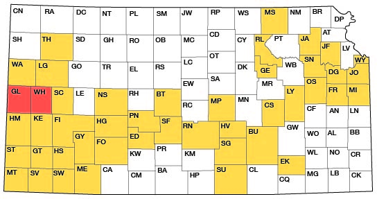
The investigation upon which this report is based is part of a program of ground-water investigations in Kansas begun in 1937 by the United States Geological Survey and the State Geological Survey of Kansas in co-operation with the Division of Water Resources of the Kansas State Board of Agriculture and the Division of Sanitation of the Kansas State Board of Health. The investigation in Wichita and Greeley counties is similar to studies that have been completed in other counties in Kansas (Fig. 1). The progressive increase in the use of ground water for irrigation in western Kansas has created a need for ground-water studies in order to get an adequate understanding of the quantity and quality of the available supply, the probable safe yield of the ground-water reservoir, and the possibility of developing additional supplies. In order to determine the changes in ground-water storage, systematic measurements of water levels are being made in several wells in Wichita and Greeley counties. This report gives the results of a study of the geology and ground-water resources of Wichita and Greeley counties, begun in July 1947.
Fig. 1--Index map of Kansas showing area described in this report and areas covered by other online geologic reports, as of Jan. 2008. For additional information, please visit the KGS Geologic Maps of Kansas Page.
The investigation was made under the general direction of A. N. Sayre, chief of the Ground Water Branch of the U. S. Geological Survey, and under the immediate supervision of V. C. Fishel, district engineer in charge of ground-water work in Kansas.
Location and Extent of the Area
Greeley County is on the western border of Kansas, midway between the north and south boundaries of the State. Wichita County joins Greeley County on the east. The two counties cover an area of approximately 1,507 square miles and contain all or parts of 45 townships from T. 16 S. to T. 20 S. and from R. 35 W. to R. 43 W., inclusive.
Previous Investigations
A detailed study of the geology and ground-water resources of Wichita and Greeley counties has not previously been undertaken, but reference has been made to the geology and ground water of parts of the two counties in several earlier reports. A geologic reconnaissance of Southwestern Kansas by Hay (1890) included the southern part of this area although it did not mention Wichita or Greeley County specifically.
In 1897 Haworth described the physiography of western Kansas and discussed the origin of the High Plains. In the same year Haworth (1897a) described the physical properties of Tertiary rocks in western Kansas. Sutton (1897) discussed history and irrigation law, described the State-financed experimental pumping station near Leoti (pp. 32-35), and included logs of two wells drilled at the site and the log of a dry hole drilled near Tribune in an attempt to establish an experimental pumping station in Greeley County. Haworth (1897b) mentioned the Wichita-Greeley area in reference to geology and ground water and included a geologic map of Kansas, geologic cross sections, and a reconnaissance hydrographic map of western Kansas. In 1897 Logan, in a report on the upper Cretaceous of Kansas, mentioned the occurrence of the Niobrara formation in Greeley County.
Johnson (1901, 1902) reported on the utilization of the High Plains, giving special attention to the source, availability, and use of ground water in western Kansas. In a preliminary report on the geology and ground-water resources of the central Great Plains, Darton (1905) briefly discussed the water supply and subsurficial geology of Wichita and Greeley counties (pp. 300, 321). A report by Parker (1911) included chemical analyses of water from wells at Horace, Tribune, and Leoti. In 1913 (Haworth) a special report on well waters in Kansas was published as Bulletin 1 of the University Geological Survey of Kansas.
An important contribution to western Kansas geology was made by Elias (1931) in a report on the geology of Wallace County, which borders Greeley on the north. This bulletin gives the results of studies of Pleistocene, Pliocene, and Cretaceous deposits in western Kansas. In 1940 Moore and others prepared a generalized report on the ground-water resources of Kansas, and a study of the geology of southwestern Kansas by Smith (1940) was published. Reports by Ver Wiebe (1944, 1947) and Ver Wiebe and others (1948, 1952, 1953) contain paragraphs concerning oil and gas test wells drilled in the counties. In addition, co-operative groundwater reports on near-by counties have been published by the State Geological Survey of Kansas (McLaughlin, 1943; Latta, 1944; Waite, 1947). A significant contribution to Pleistocene geology was made in 1952 by the publication of a report by the State Geological Survey on the Pleistocene geology of Kansas (Frye and Leonard, 1952).
Methods of Investigation
Most of the data for this report were obtained during the summers of 1947 and 1948. Data were obtained on 417 wells, most of which were measured with a steel tape to determine the depth of the well and the depth to water level. Well owners and drillers were interviewed regarding the yield and drawdown of wells and the nature and thickness of water-bearing materials. A few suitable wells were designated as observation wells and periodic measurements have since been made to determine the fluctuations in water level. Pumping tests were made on several irrigation wells to determine the yield and drawdown of the wells and the permeability and transmissibility of the water-bearing strata. Samples of water collected from 29 representative wells, from 1 deep test well, and from Ladder Creek were analyzed for chemical character in the Water and Sewage Laboratory of the Kansas State Board of Health by Howard A. Stoltenberg, chemist.
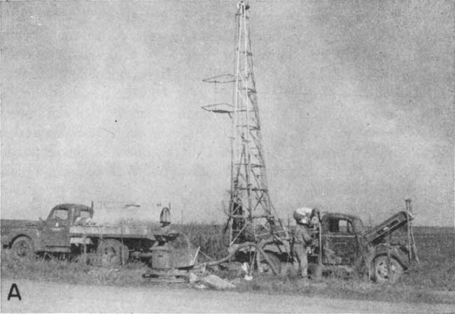
The field work included the study and mapping of the surficial geology of the area and a geologic map (Pl. 1) was prepared. The character of the material beneath the surface was determined by drilling 50 test holes at selected points through the water-bearing formations to the underlying Niobrara chalky shales. The test holes were drilled with the portable hydraulic-rotary drilling machine (Pl. 3A) owned by the State Geological Survey of Kansas and operated by William T. Connor, Joseph G. Votaw, and Glenn C. Prescott. Samples of the drill cuttings were collected and studied in the field and later examined in the office with a binocular microscope. The altitudes of the land surface at the test holes and of the measuring points of wells were determined by level parties headed by Charles K. Bayne and Woodrow W. Wilson, using a plane table and alidade.
Plate 3A--Portable drilling machine owned by the State Geological Survey of Kansas and used in drilling test holes in Wichita and Greeley counties.
The wells shown on Plates 1 and 2 were located within the sections by use of an odometer. The base map used in these plates was prepared from county maps compiled by the State Highway Commission of Kansas. The drainage shown was adapted from a map issued by the Soil Conservation Service, United States Department of Agriculture.
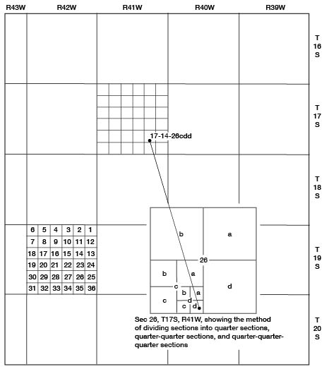
Well-numbering System
The well and test-hole numbers used in this report give the location of wells according to General Land Office surveys and in the following sequence: Township, range, section, quarter section or 160-acre tract, 40-acre tract, and 10-acre tract. The 160-acre, 40-acre, and 10-acre tracts are designated a, b, c, or d in a counterclockwise direction starting in the northeast quarter. If two or more wells are located within a 10-acre tract, the wells are numbered serially beginning with the first well measured. An example of this well-numbering system is shown in Figure 2.
Fig. 2--Map of Wichita and Greeley counties illustrating the well-numbering system used in this report.
Acknowledgments
We are indebted to the many residents of Wichita and Greeley counties who gave permission to measure their wells and who supplied information regarding them. Special acknowledgment is made to farmers who allowed pumping tests to be made on their irrigation wells. C. W. Hibbard of the University of Michigan spent several days in the field with John Branch in August 1948. Thanks are due Ben Hasz and Kenneth Rutt, well drillers from Scott City and Leoti, respectively, who furnished well logs and other information. The water superintendents of Leoti and Tribune, Fred Mueller and Charles Barnes, respectively, were very co-operative.
The manuscript for this report has been reviewed critically by several members of the Federal and State Geological Surveys; by Robert V. Smrha, chief engineer, and George S. Knapp, engineer, of the Division of Water Resources of the Kansas State Board of Agriculture; and by Dwight F. Metzler, director, and Willard O. Hilton, geologist, of the Division of Sanitation of the Kansas State Board of Health. The illustrations were drafted by Woodrow W. Wilson of the Federal Geological Survey.
Prev Page--Contents || Next Page--Geography
Kansas Geological Survey, Geology
Placed on web Jan. 11, 2008; originally published April, 1954.
Comments to webadmin@kgs.ku.edu
The URL for this page is http://www.kgs.ku.edu/General/Geology/Wichita/02_intro.html