![]()
Prev Page--Ground-water Recharge || Next Page--Availability
Discharge of Subsurface Water
Meinzer (1923, pp. 48-56) divided the discharge of subsurface water into ground-water discharge (discharge of water from the zone of saturation) and vadose-water discharge (discharge of soil water not derived from the zone of saturation). Ground water moves out of Lyon County by subsurface percolation in both the consolidated and unconsolidated rocks, eventually to be discharged by evaporation or transpiration or through springs and seeps or wells.
Evaporation and Transpiration
Evaporation and transpiration from the vadose zone account for most of the precipitation that falls in Lyon County. The use of this water is of primary importance to agriculture. Significant amounts of ground water from the capillary fringe and the zone of saturation are discharged in the valley areas. This is illustrated in Plate 4, A, B, and D and Figure 3 where the water table or capillary fringe is shown within the reach of the deep-rooted plants (phreatophytes) and many of the shallow-rooted trees and grasses.
In the upland areas where the vegetation is mostly grass, little or no ground water is lost to plants except along the outcrops of strata such as fractured or cavernous limestones which transmit ground water laterally from the zone of saturation into the surflcial slope deposits along their outcrop. Such seepage zones are generally indicated by a change in type of vegetation or a heavier growth of vegetation.
Springs and Seeps
The largest springs in Lyon County are in the northwestern part of the county and flow from the limestones of the Council Grove group. Springs in other parts of the county emerging from rocks of the Admire, Wabaunsee, and Shawnee groups are smaller in size and more variable in flow.
Low flows in the streams following intervals of no precipitation are maintained chiefly by ground-water discharge through springs and seeps into the stream (Pl. 4B).
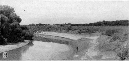
Plate 4B--Cut bank of Neosho River, SE SE sec. 14, T. 19 S., R. 12 E., showing profile of alluvial materials. Effluent seepage from gravel below point where man stands indicates water table.
Discharge by Wells
Ground water derived from wells supplies much of the domestic and stock water used in Lyon County. The amount discharged by wells, however, is very small compared with amounts discharged by the methods discussed in preceding paragraphs.
Public Water Supplies
Allen, Hartford, and Reading obtain municipal water supplies from wells. Other towns utilize ground water for domestic needs although they do not have municipal water systems. Emporia utilizes surface water from Neosho River for its public water supply.
Allen--The water supply of Allen, Kansas, is derived from one 6-inch well drilled in 1948, (16-11-22ad1). The well is 32 feet deep and is about 0.5 mile south of the city. It is equipped with a vertical turbine pump having a capacity of 20 gallons per minute and powered by an electric motor. Reservoir storage is limited to a small metal pressure storage tank in the pump house. A second 6-inch drilled well (16-11-22ad2) is 28 feet deep and is about 0.1 mile north of the first well. This well is not equipped with a pump. The well in use obtains water from cavernous zones in the Long Creek limestone. Dissolved solids, total hardness, and sulfate content are unusually high. The nitrate content of the water also is high.
A chemical analysis of the water is given in Table 4.
Hartford--The Hartford water supply is obtained from two wells. The city well, known as the "Pete Rich" well, penetrates alluvium and is east of Neosho River in Coffey County. It is a dug well 30 or 35 feet deep and 12 to 16 feet in diameter. Pumping equipment consists of a Deming triplex pump, rated at 100 gallons per minute, powered by a l0-horsepower electric motor. The pump empties the well in about 40 minutes. The second well (20-13-l5dd) is a dug well about 4 feet in diameter and 30 feet deep. The well is in the southeast part of the city and obtains water from terrace deposits. It is equipped with a motor driven thresher-type pump having a capacity of 1,000 gallons per hour. This well is used only in emergencies.
A chemical analysis of the water is given in Table 4.
Reading--The Reading water supply is derived from two dug wells. One well (17-13-34da) is about 0.5 mile north of town in the alluvium of Marais des Cygnes River. It consists of a 6-foot square concrete pit about 15 feet deep with a 24-inch diameter perforated galvanized iron casing about 17 feet long extending from the bottom of the concrete pit to the base of the well. The galvanized iron casing is surrounded by an 18-inch layer of gravel. The well is equipped with a 100 gallons per minute centrifugal pump powered by a 5-horsepower electric motor.
A second well (18-13-3bd) about 0.3 mile south of Reading obtains water from creek alluvium. It is similar in construction to the north city well and is equipped with a l00-gallon-per-minute centrifugal pump powered by an electric motor. This well is not used regularly but only in emergencies.
Industrial Supplies
The large industrial users of water, including the Atchison, Topeka, and Santa Fe Railway Company, Panhandle Eastern Pipe Line Company, Fanistel Packing Company, and Kansas Soya Products Company use water supplied by the City of Emporia.
Prev Page--Ground-water Recharge || Next Page--Availability
Kansas Geological Survey, Lyon County Geohydrology
Web version Sept. 2001. Original publication date March 1953.
Comments to webadmin@kgs.ku.edu
The URL for this page is http://www.kgs.ku.edu/General/Geology/Lyon/pt2_disc.html