![]()
Prev Page--Utilization, Chemical Character || Next Page--Well Records
Geologic Formations and their Water-bearing Properties
Cretaceous System
Gulfian Series
Dakota Formation
Character--The oldest formation known to yield water to wells in Lane County is the Dakota formation of the Gulfian Series of the Upper Cretaceous System. The Dakota is probably underlain by the Kiowa shale and the Cheyenne sandstone, but owing to lack of detail, little information concerning the character and thickness of these formations has been gained from the study of logs or deep oil and gas test wells drilled in the county. The formations below the Greenhorn limestone and above the Permian redbeds are similar in lithology and may be logged as one unit by oil-well drillers and described as a "group" by oil geologists. As no wells in Lane County are known to derive water from the Cheyenne sandstone or Kiowa shale, these formations will not be discussed further.
The Dakota formation is not exposed in Lane County and, because of its depth, was nowhere encountered in test holes drilled by the State Geological Survey. The closest outcrops of the Dakota are in southern and eastern Hodgeman County, where only the upper 50 or 60 feet of the formation is exposed (Moss, 1932, p. 32).
The Dakota is composed mainly of variegated clays and shales and lenticular sandstone beds. The sandstones generally are crossbedded. The sandstones of the Dakota formation are interbedded with and interfinger with clay and silty clay. McLaughlin (1943, p. 121) found that in Hamilton County about 40 to 45 percent of the formation consists of varicolored clay. The ratio of sandstone to shale and clay varies from place to place. Only about one-fourth of the formation is sandstone in Ness and Hodgeman counties (Moss, 1932, p. 32). White to reddish sandstone and gray shale are the predominating beds in Lane County.
Distribution and thickness--The Dakota formation underlies all of Lane County and has been encountered in several test wells for oil and gas and in water wells. The study of samples of a test well for oil in the NW NE sec. 16, T. 16 S., R. 28 W. indicates that the thickness of the Dakota formation, Kiowa shale, and Cheyenne sandstone is about 500 feet. Because of the similarity of the drill cuttings exact boundaries were not drawn, but the Dakota was approximately 300 feet in thickness. According to Landes and Keroher (1939, p. 24) the thickness (including Kiowa and Cheyenne) ranges from 450 to 550 feet in Logan, Gove, and Trego counties. Because of the lenticular nature of the Dakota formation its thickness varies widely.
Water supply--The Dakota formation is not an important aquifer in Lane County, but it does yield water to several deep wells in areas where the Ogallala formation is thin or absent. Water in the Dakota is under artesian pressure but Lane County has no flowing wells. An analysis of the water from well 16-28-4bcd is shown graphically in Figure 10. The water from wells in the Dakota is soft sodium bicarbonate water, being very low in calcium and magnesium and very high in sodium. The analyses indicate that the water in the Dakota formation in this area has undergone a natural softening in which calcium bicarbonate water has exchanged its calcium and magnesium for sodium by a base-exchange process.
The base-exchange silicates active in the natural softening process are the clay-forming minerals in the Dakota formation. The degree of softening depends upon the amount and softening capacity of the clay-forming minerals and upon the length of time the hard water remains in contact with these minerals (Renick, 1924).
The water from the Dakota formation ranges in hardness from 22 to 49 parts per million and is considered soft. The fluoride content ranges from 5.0 to 8.0 parts per million and would be very undesirable for a drinking supply to be used by young children. The percentage of sodium is very high in water from the Dakota formation--in one sample sodium constituted 98 percent of the total bases. Water of this composition is unfit for irrigation.
Graneros Shale
Character--Conformably overlying the Dakota formation is the Graneros shale, which consists of noncalcareous shale ranging from dark blue to black in fresh samples and from gray to brown in weathered exposures. It contains a few thin beds or lenses of sandstone and sandy shale. The contact between the Graneros shale and the Dakota is not everywhere distinct but may consist of a transitional zone in which sandstones and shales of the Dakota grade upward into sandstones and sandy shales of the Graneros. The top of the formation at most places is marked by a sharp lithologic break between the noncalcareous Graneros shale and the overlying calcareous beds of the Greenhorn limestone.
Distribution and thickness--The Graneros shale is not exposed in Lane County and it was not encountered in any test holes. It probably underlies the entire county. The nearest exposures of the Graneros are in southern Hodgeman County and along Sawlog Creek in northern Ford County. The thickness of the Graneros in Lane County is about 50 feet.
Water supply--No wells are known to obtain water from the Graneros shale in Lane County. Because of the low permeability of the sediments the quantity of water available in the shales and sandstone lenses is small.
Greenhorn Limestone
Character--The Greenhorn limestone consists of thin chalky and crystalline limestones separated by thicker beds of chalky shale, which contain thin bentonite beds. Limestone concretions are common in the shales in the upper part of the formation. Fresh exposures of limestone and shales are dull gray, and the bentonites are light pearly gray. Upon weathering, the color of the limestones becomes tan, buff, or orange tan. The shales in the upper part weather to tan or light gray, and those in the lower part, to tan or orange tan. The bentonite weathers to rusty brown or orange. The Greenhorn limestone grades upward into chalky shale beds of the Fairport member of the Carlile, so there is no distinct lithologic break between the formations. The base of the Greenhorn is marked distinctly by a change from the noncalcareous beds of the Graneros to the chalky shales and the crystalline limestones at the base of the Greenhorn. The Greenhorn has been divided into four distinct members, but where the Greenhorn is known only from drill cuttings it is not possible to differentiate the members.
Distribution and thickness--The Greenhorn limestone underlies all of Lane County but does not crop out in the county. The nearest exposures are in Ness and Hodgeman counties. The thickness in Lane County is about 100 feet; it is approximately 1-25 feet in Hodgeman County (Moss, 1932, p. 26) and about 100 feet in Logan, Gove, and Trego counties (Landes and Keroher, 1939, p. 24).
Water supply--None of the wells visited in Lane County obtain water from the Greenhorn limestone. The water-yielding capacity of the formation is low, although water may occur in fractures and solution openings in the limestone. A few wells in southeastern Gray County (Latta, 1944, p. 153) and a few in Ford County (Waite, 1942, p. 154) probably obtain water from the Greenhorn.
Carlile Shale
Character--The Carlile shale is the oldest Cretaceous formation exposed in Lane County. It is composed of two members, the Fairport chalky shale member and the Blue Hill shale member. The Fairport chalky shale member, which usually constitutes the lower one-third of the formation, consists of thick beds of chalky shale alternating with thin beds of chalk or chalky limestone. Many hard concretions occur in the lower part of the member and a few bentonite beds occur in the shale. The Fairport contains many poorly preserved fossils, the most common being Inoceramus fragilis, Prionotropis woolgari, Ostrea congesta, Globigerina, Gumbelina, and Serpula plana.
The Blue Hill shale member generally constitutes most of the upper two-thirds of the Carlile shale. It consists of dark-gray to bluish-black noncalcareous shale and contains seams and crystals of gypsum and, in the upper part, a zone of large septarian concretions.
The Codell sandstone is a sandy zone at the top of the Blue Hill shale member of the Carlile. Where exposed in the southeastern part of Lane County it consists of about 2 feet of tan fine-grained sandstone and sandy shale grading downward into the shale of the Blue Hill member.
Distribution and thickness--The Carlile shale is present at the surface or beneath the surface everywhere in Lane County. The Blue Hill shale member, which contains the Codell sandstone zone, crops out in the southeastern part of the county, but the Fairport chalky shale member is nowhere exposed. The thickness of the Carlile in Lane County is 200 feet, the Fairport being about 90 feet and the Blue Hill 110 feet thick (oil well test 16-28-16ab).
Water supply--No wells in Lane County are known to obtain water from the Carlile shale. The Blue Hill and Fairport chalky shales generally do not yield water to wells but in Hamilton, Kearny (McLaughlin, 1943, p. 133), Finney, and Gray (Latta, 1944, p. 157) counties the Codell is generally thicker than in Lane County and may yield small quantities of water to wells in some places. In Lane County, however, the Codell is thin, very fine-grained, and relatively impermeable.
Niobrara Formation
Character--The Niobrara formation consists of beds of chalk, limestone, chalky shale, and chalk, with chalky shale predominating. The Niobrara has been divided into two members--the Fort Hays limestone member below and the Smoky Hill chalk member above.
The Fort Hays limestone member is composed of thick massive beds of chalk or chalky limestone separated by thin beds of chalky shale. Some of the chalk beds are 6 feet thick, but the average is less than 3 feet. Shale partings are thin and are usually less than 4 inches. Fresh exposures of the Fort Hays are white or light gray, and weathered outcrops are white, tan, buff, or cream. The contact of the Fort Hays limestone with the underlying Carlile shale is marked distinctly by a sharp change from light-colored calcareous beds of the Fort Hays to the dark-colored noncalcareous beds (sandstone, sandy shale, or shale) of the Carlile. The Fort Hays contains the fossil pelecypods, Inoceramus deformis and Ostrea congesta and many minute foraminifera which occur in the chalk beds.
The following measured section (shown on Pl. 4B) indicates the character of the Fort Hays limestone in southern Lane County.
| Section of the Fort Hays limestone member of the Niobrara formation in the SW sec 2, T. 19 S., R. 27 W. | Thickness | ||||
|---|---|---|---|---|---|
| Feet | Inches | ||||
| Cretaceous--Gulfian | |||||
| Niobrara formation (Fort Hays limestone member) | |||||
| 25 | Limestone, broken, white | 1 | 2 | ||
| 24 | Shale, chalky, light-tan | 2 | |||
| 23 | Limestone, massive | 1 | 4 | ||
| 22 | Shale, light-tan | 1 | |||
| 21 Limestone, massive, white | 2 | 1 | |||
| 20 | Shale, light-tan | 1 | |||
| 19 | Limestone, shaly, light-tan | 3 | |||
| 18 | Shale, light-tan | 1 | |||
| 17 | Limestone, massive | 8 | |||
| 16 | Shale, light-gray | 3 | |||
| 15 | Limestone, massive, white | 2 | 11 | ||
| 14 | Shale, light-tan | 1 | |||
| 13 | Limestone, massive, white | 1 | 10 | ||
| 12 | Shale, light-brown | 1 | |||
| 11 | Limestone, massive, white | 1 | 5 | ||
| 10 | Shale, light-gray | 1 | |||
| 9 | Limestone, massive, white | 2 | 4 | ||
| 8 | Limestone, shaly, light-tan | 10 | |||
| 7 | Limestone, white | 9 | |||
| 6 | Shale, chalky, light-tan | 1 | |||
| 5 | Limestone, white | 10 | |||
| 4 | Shale, chalky, light-tan | 1 | |||
| 3 | Limestone, massive, light-tan | 1 | 3 | ||
| 2 | Shale, chalky, light-tan | I | |||
| 1 | Limestone, fractured, light-tan | 1 | |||
| Total | 19 | 6 | |||
Conformably overlying the Fort Hays limestone member of the Niobrara formation is the Smoky Hill chalk member. It consists of soft beds of alternating chalky shale and chalk. Where unweathered, the beds are light to dark gray, but on weathering they become white, tan, buff, or yellowish pink. Thin bentonite beds and pyrite concretions are common in the Smoky Hill member. Bentonites are light colored when unweathered, but weather to a rusty brown. Pyrite concretions weather to limonite and exposures of chalk beds in many places are strewn with hard steel-gray concretions of pyrite or discoidal soft yellow-brown concretions of limonite many of which are a foot in diameter.
The Smoky Hill chalk member, especially in Logan and Gove counties, has long been famous for the large number of fossils, both vertebrate and invertebrate, that it contains. Many of the large natural history museums of the world exhibit vertebrate fossils that came from the Smoky Hill chalk member of central and western Kansas. Vertebrates that have been found here include primitive birds, reptiles of many varieties, dinosaurs, and fish. The most abundant invertebrate fossils are Inoceramus grandis, a large pelecypod, and Ostrea congesta, a small oyster which often is attached to the larger Inoceramus shells. Foraminifera, chiefly Globigerina and Gumbelina, are very abundant in the chalk beds.
Fossil wood has been found in the formation. Williston (1897a, p. 243) reported a tree about 30 feet long discovered near Elkader in Logan County. I found a fossil tree trunk imbedded in the chalk in sec. 11, T. 16 S., R. 28 W. It was about 6 feet long and had been altered to lignite. The specimen could not be identified as no plant structures were recognizable.
Distribution and thickness--The best exposures of the Smoky Hill chalk member in Lane County are in the northern part along small valleys tributary to Smoky Hill River and along the south fork of Walnut Creek east of Dighton. The Fort Hays limestone member crops out in the southeastern part of the county. The county is everywhere underlain by Fort Hays with the exception of areas where the Carlile shale crops out, but in parts of southeastern Lane County, the Smoky Hill has been removed by erosion. None of the test holes drilled by the State Geological Survey of Kansas penetrated the entire thickness of the Niobrara. Logs of oil-well tests drilled in Lane County indicate that the Niobrara may attain a thickness of about 400 feet, the Fort Hays member being about 50 feet thick and the Smoky Hill chalk being about 350 feet thick.
The contact between the Smoky Hill chalk member and the Fort Hays member is transitional from predominantly chalk beds in the Fort Hays to predominantly chalky shale beds in the Smoky Hill. A pair of bentonite seams is arbitrarily taken to be the top of the Fort Hays. Actually the top is several feet below the top of the uppermost thick chalk bed, but these bentonites are the only convenient and recognizable horizons at which to make a division. In Lane County the contact between the Fort Hays limestone and Smoky Hill chalk is exposed at only one place. In the SW SE sec. 31, T. 20 S., R. 27 W., both the Smoky Hill and the Fort Hays crop out. The contact is obscured by slope deposits, but seemingly the Smoky Hill is about 20 feet thick at this locality. Just across the county line in sec. 1, T. 21 S., R. 28 W., Finney County, the Smoky Hill chalk member is directly overlain by the "Algal limestone" of the Ogallala formation.
Water supply--The Niobrara is not an important water-bearing formation in Lane County. The beds of chalk and chalky shale that make up the Fort Hays and Smoky Hill are relatively impervious and transmit water chiefly through fractures. The success of a well penetrating the Niobrara depends upon whether or not fractures are encountered. Several wells in areas in Lane County where Pleistocene and Pliocene deposits lie above the water table derive at least part of their water from the Niobrara. Amounts of water yielded by the Niobrara are small.
No samples of water were collected from wells obtaining water from the Niobrara formation. However, according to Latta (1944, p. 160) and Waite (1947, p. 118) the chemical character of water from the Niobrara formation is similar to that of water from Pliocene and Pleistocene deposits.
Tertiary System
Pliocene Series
Ogallala Formation
Character--The Ogallala formation in Lane County consists chiefly of silt, clay, sand, and gravel, and some limestone. In other areas beds of volcanic ash, diatomaceous marl, bentonitic clay, and hard silicified beds resembling chert or quartzite are found. The character of the Ogallala is shown in logs of test holes included in this report. Despite the diversity of rock types found within the Ogallala, the outcrop pattern presents a uniformity of aspect that makes the formation easily identified.
With the exception of a limestone member at the top of the formation, the beds are characteristically lenticular and can be traced only short distances. In general the materials composing the formation are poorly sorted and gradations from one lithologic type to another may take place within short distances both laterally and vertically.
Sand, the principal constituent of the Ogallala formation, occurs at all horizons. It may be found in beds of silt or clay or in sandy limestones. It ranges in texture from fine- to coarse-grained. The sand is composed predominantly of quartz, but contains subordinate amounts of feldspar and other minerals. A few lenses of sand encountered in test drilling were relatively well sorted and free from other constituents, but most of them were poorly sorted, being mixed with silt, clay, or gravel. Deposits of well-sorted sand or sand and gravel are uncommon in the Ogallala.
The Ogallala contains many beds that are composed mainly of sandy silt and clay. The color of the silt is gray, brown, tan, or buff. Where it contains much lime it may be white. The sandy silt lenses may contain nodules or stringers of calcium carbonate as well as calcium carbonate cement.
Gravel in the Ogallala ranges in size from fine to coarse and may occur in almost any part of the formation. In several test holes drilled in Lane County the gravels at the base of the formation are coarser and thicker. Ordinarily the gravel is mixed with a considerable amount of sand and silt, thus rendering the formation less permeable to ground water.
Much of the material in the Ogallala is cemented, generally with calcium carbonate. Some of the beds of sand and gravel are firmly cemented with calcium carbonate to produce a series of hard ledges of sandstone, interbedded with only slightly cemented beds. The hard ledges are generally unevenly cemented and form rough weathered benches and cliffs called "mortar beds" (Pls. 6B, 7A). The first use of the term "mortar bed" applied to soft caliche rather than the sandstone. It was used as mortar in building early-day buildings.
Plate 7--The Ogallala formation in Lane County. A, Crossbedded partially cemented sand and gravel in the Ogallala formation; SW NE sec. 1, T. 18 S., R. 28 W. B, Caliche bed in Ogallala formation; photograph taken in a pit silo excavated in caliche, NW sec. 26, T. 16 S. R. 30 W.
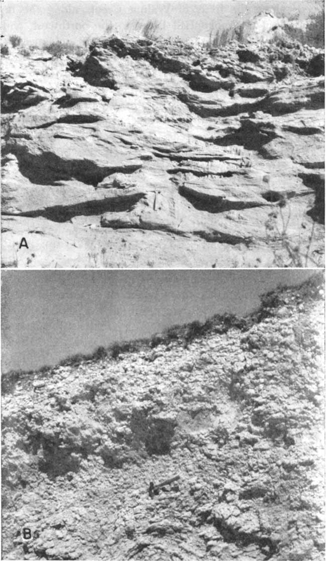
Calcium carbonate is present as cementing material, nodules, concretions, lenses, and beds. The thickness of bedded caliche (calcium carbonate) in the Ogallala ranges from a few inches to about 12 feet (test hole log 18-29-15ccc). It is generally white and is fairly soft. Plate 7B is a photograph taken in a pit silo excavated in a bed of white caliche in the NW sec. 26. T. 16 S., R. 30 W.
In some places the Ogallala formation is capped by a distinctive limestone layer, called "Algal limestone" (Elias, 1931, p. 136-141) because of its peculiar concentrically banded structure. The "Algal limestone" has a maximum thickness in Lane County of about 4 feet and in typical outcrops is reddish. It is hard and weathers to a knobby, irregular surface. Elias and Landes (Elias, 1931, p. 141) observed outcrops of "Algal limestone" 3 miles northwest of Alamota in Lane County, and along Highway K-96 on the eastern border of Lane County. I found 20 additional localities where limestone with prominent algal structure was exposed. I also found several other limestone beds lacking the concentric algal structures but otherwise similar to the Ogallala caprock.
Distribution and thickness--Exposures of the Ogallala formation occur along the forks of Walnut Creek, along the heads of draws tributary to Smoky Hill River to the northwest, and along other drainage ways. In several of these areas ephemeral streams have cut through the Ogallala into the underlying Smoky Hill chalk member. Other isolated Ogallala outcrops, many of them "Algal limestone", occur throughout the county. Most of the upland surface in Lane County is mantled by deposits of Pleistocene age. The Ogallala formation, however, is found beneath younger deposits over most of the area. It is absent in some areas in the southeastern part of the county where it has been removed by erosion, thus exposing the underlying Cretaceous rocks. It has also been removed in some areas along the northern border of the county. In test holes 20-30-21ccc and 20-30-31ccc in southwestern Lane County the Ogallala formation was not encountered. It is probable that in this area the Ogallala formation was removed by erosion and sediments of Pleistocene age were deposited in its place.
The thickness of the Ogallala varies greatly because of the irregular Cretaceous surface upon which the sediments were deposited and in part because some of or all the sediments were removed by post-Ogallala erosion. The Ogallala formation ranges in thickness from a few feet to about 160 feet. The thickness of Ogallala sedimentary rocks encountered in test drilling ranged from 16 to 160 feet. The formation is thickest in the northwestern part of the county in the vicinity of Healy and in general becomes progressively thinner southward and southeastward.
Origin--The Ogallala formation was deposited mainly by streams that flowed from the Rocky Mountain region. As time went by, stream channels became filled with deposits. This led to overflow of the streams and the building of broad flood plains. Erosion continued in the upland areas and deposition took place along the streams. Eventually the valleys became filled, divides were covered, and the depositional zones of individual streams overlapped.
Not all the Ogallala sediments were deposited by running water. At various times shallow lakes formed by the damming of stream channels were probably in existence. Beds of volcanic ash seem to have been deposited in still water (Frye and Leonard, 1949, p. 39) and the "Algal limestone" also formed in quiet water.
Most of the constituent materials of the Ogallala formation were derived from weathered rocks from the Rocky Mountains. Locally derived fragments of the Niobrara formation are also found near the base of the Ogallala. Some of the calcium carbonate that is very abundant in the Ogallala has probably been deposited by percolating subsurface water or ground water after the deposition of the rocks.
Age and correlation--The Ogallala formation was named by Darton in 1899 (pp. 732, 734) from a locality in southwestern Nebraska, and its age was given as late Tertiary or Pliocene (?). In 1920 Darton (p. 6) designated the type locality as being near Ogallala station in western Nebraska. Elias (1931) made a detailed study of the Ogallala formation in Wallace County and in 1937 briefly described the Ogallala deposits in Rawlins and Decatur counties. These deposits have recently been described in several southwestern Kansas counties (Frye, 1942; Latta, 1941, 1944, 1948; McLaughlin, 1942, 1943; Waite, 1942, 1947) and in two counties in northern Kansas (Frye, 1945; Frye and Leonard, 1949).
The Ogallala formation is considered by the State Geological Survey of Kansas to range from early to late Pliocene in age. The Ogallala is subdivided into three members, which are in ascending order, the Valentine, Ash Hollow, and Kimball. The top of the Kimball is marked by the "Algal limestone". The Ogallala was not subdivided in Lane County.
Water supply--The sand and gravel of the Ogallala formation is the most important source of ground water in Lane County. Most of the domestic and stock wells in the upland areas, all the public supply wells, and all the irrigation wells being pumped in 1948 derive water from the Ogallala formation. In addition the Ogallala supplies water to several springs in the county. The yields of wells tapping the Ogallala range from a few gallons a minute for small domestic and stock wells to about 1,200 gallons a minute for one irrigation well. The irrigation wells obtain their water from coarse materials that generally occur in the lower part of the Ogallala. The coarser materials, gravel and coarse sand, are good water bearers and generally yield abundant supplies of water where they occur beneath the water table. On the other hand, finer materials are generally rather porous and hold much water, but are not sufficiently permeable to yield water freely.
The permeability of a water-bearing material (its capacity for transmitting water under pressure) is described under permeability of water-bearing materials. Laboratory determinations of coefficients of permeability of samples from the Ogallala of Lane County were not made, but determinations on similar materials from Thomas County showed a range from 107 to 609 for uncemented sand and gravel (Frye, 1945, p. 65). Coefficients of permeability determined by pumping tests in Lane County ranged from 320 to 3,400, indicating that the permeability of sand and gravel beds in the Ogallala in places is sufficient to allow the development of wells of high capacities.
The thickness of saturated material in the Ogallala is shown in Figure 9 and in the cross sections in Figure 6. Logs of test holes indicate that much of the saturated zone of the Ogallala is composed of sand and gravel; therefore the amount of water in storage is large.
Water samples were collected from 20 wells that obtained water from the Ogallala formation. Analyses of the samples of water are given in Table 5 and graphic analyses of typical waters from the Ogallala are shown in Figure 10. Of the 21 samples of Ogallala waters analyzed, only one had a total hardness of less than 200 parts per million; 15 had a hardness of 200 to 300 parts; three had a hardness of 300 to 400; and two had a hardness of more than 400 parts per million. Hardness ranged from 188 to 461 parts per million. The iron content, generally low, had a maximum of 2.5 parts per million. The fluoride content of the 21 samples ranged from 0.7 to 4.5 parts per million. Three samples contained from 0.6 to 1.0 part per million, 4 contained from 1.1 to 1.5, 7 contained from 1.6 to 3.0, and 7 contained from 3.1 to 4.5 parts per million of fluoride. The fluoride content of most of the samples of Ogallala water is high and should be considered where the supply will be used for drinking purposes by children. Analyses indicate that water from the Ogallala formation is well within safe limits suggested for irrigation.
Quaternary System
Pleistocene Series
Meade (?) Formation
Character--The Meade (?) formation consists mainly of sandy silt and clay and very fine sand. At the base it contains fine sand and a little gravel. The gravel contains pebbles derived from the underlying Smoky Hill chalk member. The Meade in many places contains a volcanic ash bed, the Pearlette ash, but no ash was identified from well cuttings in Lane County. A terrace deposit along a tributary to Smoky Hill River on the northern border of the county is also tentatively classified as Meade formation and consists of sand, gravel, and silt.
Distribution and thickness--In Lane County, the Meade formation is limited to a few square miles in the southwestern part of the county and to a small terrace remnant along a tributary to Smoky Hill River in sec. 3, T. 16 S., R. 29 W. It ranges from a featheredge to about 120 feet in the southwest; it is thin in sec. 3, T. 16 S., R. 29 W.
Age and correlation--Although the constituent materials in the Meade (?) deposits in southwestern Lane County are considerably different from the undifferentiated Pleistocene deposits of Scott County, I believe that they are of the same age. The basin in southwestern Lane County probably joins the Scott-Finney basin in northern Finney County. In order to prove this, more test holes must be drilled in Finney County.
The evidence of fossils indicates that at least part of the undifferentiated Pleistocene deposits in Scott County may be properly called Meade. A skull and horns of Superbison latifrons, a species commonly found in the lower part of the Meade, were unearthed in a gravel pit in Scott County (Waite, 1947, pp. 132-133; Colbert, 1948, p. 569). Teeth of Parelephas columbi, a mammoth found in Meade deposits, were also discovered in gravel deposits of Scott County. However, remains of this species have been found in younger Pleistocene deposits in Kansas (Frye, 1942, p. 110) and in Nebraska (Lugn, 1935, p. 142).
The Meade formation in Kansas is separated into two members, the lower or Grand Island member which generally consists of sand and gravel, and the upper or Sappa member which generally consists of stratified sand and silt and may contain the Pearlette volcanic ash (Frye, Swineford, and Leonard, 1948, pp. 518-523). In a road cut in the NW NW sec. 3, T. 16 S., R. 29 W. Peoria loess rests on a soil profile developed on the Loveland loess. The Loveland rests on terrace materials that consists of sands and silts of the Sappa member and sands and gravels of the Grand Island member. No volcanic ash was noted at this place, but in the SE sec. 26, T. 15 S., R. 28 W. in Gove County, Pearlette ash was found in a terrace along a tributary to the Smoky Hill. Because the Meade (?) is exposed only in a very small area in sec. 3, T. 16 S., R. 29 W. (it is covered by dune sand and a thin loess mantle in southwestern Lane County) it was included with the Sanborn formation in the geologic mapping.
Water supply--The Meade (?) yields water to several wells in southwestern Lane County. It contains a large amount of water, but the water-bearing beds are composed of fine materials and no large yields can be obtained.
A water sample was collected from one well obtaining water from the Meade (?) formation. It was very similar in quality to Ogallala waters although it was slightly harder and contained more dissolved solids than most samples of Ogallala water. Its fluoride content was less than in most Ogallala waters.
Sanborn Formation
Character--In 1931 Elias (pp. 163-181) described unconsolidated Pleistocene deposits consisting mostly of silt in northwestern Cheyenne County, Kansas, and named these deposits Sanborn formation from the town of Sanborn, Nebraska, just north of the type area.
Elias recognized three types of loess in Wallace County: loess of the divides, loess of the valley slopes, and valley-bottom loess. He considered that (1931, pp. 179-180)
. . . only the loess that covers the divides can be considered of Pleistocene age (and, therefore, Sanborn formation), the loess of the valley slopes and bottoms being largely if not wholly redeposited from the divides, the redeposition having taken place probably for the most part in late Pleistocene and Recent times.
Most geologists consider that loess is eolian silt, having been transported and deposited by the wind. However, Elias applied the term loess to colluvial slope deposits that are composed of reworked loess from the divides, including some fragments of locally derived bedrock. Wind, surficial water, and slope processes have been the chief agents of transportation of these slope deposits. Elias also classed as loess certain deposits that he called valley-bottom loess. These deposits grade downward into alluvial sands and gravels and must be regarded as part of the alluvial deposits (Elias, 1931, p. 180).
Slope deposits of Recent age similar to those described in Wallace County (Elias, 1931) are extensive in Lane County and cover the slopes of most of the valleys. Where the parent material consists entirely of the Sanborn formation, slope deposits are indistinguishable from the Sanborn. In this report the term "loess" includes only loess that covers the divides. However, because of the similarity in character between colluvial slope deposits and loess of the divides, slope deposits are included with the Sanborn formation on the geologic map. In some areas, especially along the western end of the north fork of Walnut Creek, the Ogallala crops out at the side, whereas the stream channel is shown to cut into the Sanborn formation (Pl. 1). Presumably, the stream should also cut into the Ogallala because the stream is at a lower altitude than the Ogallala outcrops along the sides. The inclusion of slope deposits with Sanborn formation on the geologic map is the reason for this apparent discrepancy, the slopes between the Ogallala outcrops and the stream channel below in places being covered with colluvial slope deposits.
In Lane County two members of the Sanborn formation, the Peoria silt member and the Loveland silt member, have been recognized. The unconformity between the two is identified by a well-developed fossil soil zone at the top of the Loveland silt member. This soil zone is exposed in road cuts throughout the area and it has been encountered in some of the test holes (Pl. 8).
Plate 8--The Sanborn formation in Lane County. A, Peoria silt member of Sanborn formation, SE NE sec. 15, T. 16 S, R. 29 W. B, Peoria silt member of Sanborn formation lying on fossil soil zone developed on Loveland silt member; on east side of Highway 23, northern Lane County in the NW SW sec. 2, T. 16 S., R. 29 W. View looking northwest.
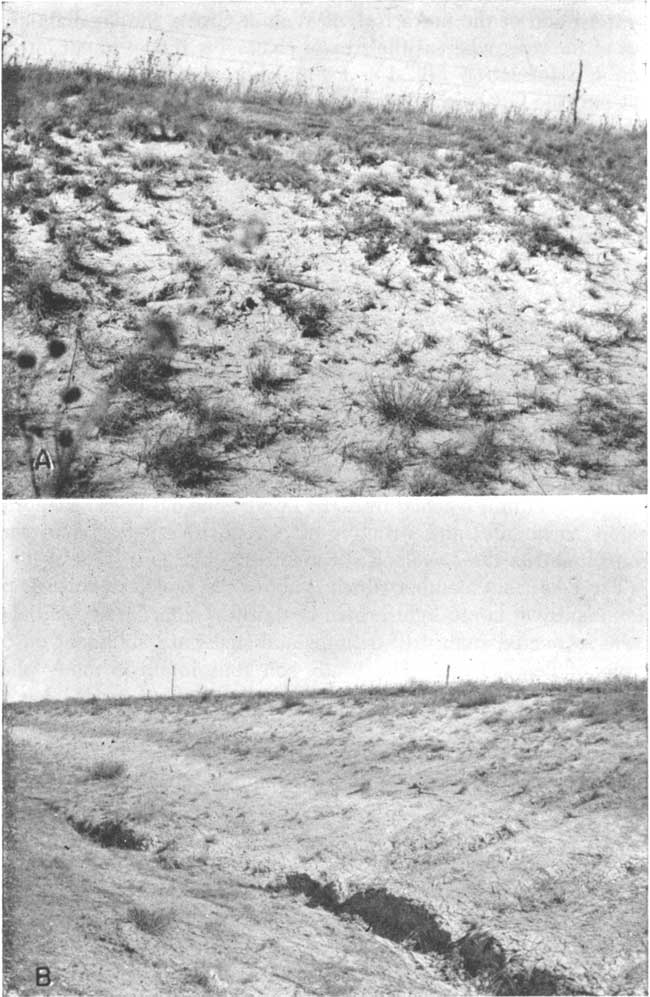
The Loveland silt member consists of massive reddish-brown silt. At the top is a leached zone that is dark reddish-brown in color owing to oxidation and probably some organic material. A concentration of lime leached from the upper zone has been redeposited below as nodules and stringers of caliche. Very few snail shells were found in the Loveland silt member.
The Peoria silt member which is above the Loveland consists predominantly of tan to light-brown unstratified silt. Many snail shells were recovered from drill cuttings and snails are abundant on outcrops of Peoria loess. The Brady soil zone found in many places at the top of the Peoria (Frye and Leonard, 1949, p. 46) has not been recognized in Lane County.
According to Elias (1931, p. 163) the basal part of the Sanborn loess is everywhere sandy and in many places coarse gravel is found at the base of the formation. Boulders as much as 2 1/2 feet in diameter were noted in Wallace County. Test wells drilled in Lane County indicate that the basal part of the Sanborn may be sandy and may contain small amounts of gravel, but the coarse gravel described by Elias (1931, pp. 163-178) either is lacking or was not recovered from the test holes. However, in several localities throughout the county thin sheets of gravel composed of pebbles of basalt, quartz, quartzite, jasper, and flint (often as petrified wood), mantle the underlying rocks, generally the Smoky Hill chalk member of the Niobrara formation. This gravel is considered to be equivalent to the basal gravels of the Sanborn of Elias.
Distribution and thickness--As indicated on the geologic map (Pl. 1), much of the surface of Lane County is underlain by the Sanborn formation. Most of the test holes drilled in the county encountered loess deposits. Because road cuts and other excavations are generally shallow and because natural exposures are few and small, the thickness of the Sanborn formation or of its members is not determinable. The greatest thickness of the Sanborn formation penetrated in test drilling was about 25 feet in test hole 18-30-21bbb.
Age and correlation--The name Sanborn formation was first used in 1931 (p. 163) by Elias for the loess (with some sand and gravel at the base) that is widely distributed on the divides in western Kansas. The name replaced such terms as "Tertiary marl" and "Plains marl" used by Robert Hay (1895) and other early workers in the central Great Plains region. Elias considered that these deposits were Pleistocene. In the type section of the Sanborn formation south of Sanborn, Nebraska, stratigrapbic units equivalent to the Peoria loess and the Loveland loess have been identified as well as a less well-developed fossil soil that may be equivalent to the Brady soil. Correlations of the various units exposed in the type section of the Sanborn have been made eastward across northern Kansas to the glaciated area. The loesses and buried soils have been traced by outcrops and auger holes southward from Jewell County across the uplands of Mitchell and Lincoln counties to Rice and McPherson counties (Frye and Fent, 1947, pp. 41, 42). Condra, Reed, and Gordon (1947) have traced the Loveland loess and the Peoria loess from western Iowa across Nebraska to eastern Colorado and into Kansas and Missouri. In Nebraska the Peoria silt member has been found beneath Iowa till and has been establisbed as post-Iowan glaciation in age. The Loveland silt member underlies the Iowa till in places and is pre-Iowan glaciation in age.
Fossil snails collected from the Sanborn formation in Lane County by A. Byron Leonard and John C. Frye are listed below (Frye and Leonard, 1951, fig. 4).
| Fossil snails from the Peoria silt member of the Sanborn formation in Lane County (identified by A. Byron Leonard) |
|
| Vallonia gracilicosta Reinhardt | Helicodiscus parallelus Say |
| Pupilla blandi Morse | Discus shimeki Pilsbry |
| Pupilla muscorum Linne | Lymnea parva Lea |
| Hawaiia miniscula Binney | Vertigo milium Gould |
| Succinea avara Say | Discus cronkhitei Newcomb |
Water supply--In most of Lane County the Sanborn formation lies above the water table and yields no water to wells. However, it is thought that in a few isolated areas where the water table is close to the surface the Sanborn may yield water to wells, probably from sand or gravel at the base of the formation. No analyses of water from the Sanborn formation were obtained. Because of the impermeability of its silts, the Sanborn exerts a strong retarding effect on ground-water recharge.
Dune Sand
Dune sand of Quaternary age covers an area of about 5 square miles in the southwestern corner of Lane County, and a small isolated dune occurs along the Lane-Finney county line 4 miles east of the border of Scott County (Pl. 1). The dune sand is composed predominantly of fine- to medium-grained quartz sand and contains smaller amounts of coarse sand, silt, and clay. The sand has been accumulated by the wind to form small hills and ridges. Most of the sand hills are covered by sparse vegetation, but in some spots there are areas of bare sand that are being subjected to renewed wind action. The thickness of the sand dunes in this area has not been determined but the maximum thickness of the sand probably is between 30 and 40 feet. The source of the dune sand is uncertain, but it probably was the near-by Pleistocene and Pliocene deposits or possibly the terrace deposits along Arkansas River. A detailed discussion on sand dunes is found in a report by Smith (1940, pp. 127-128; 153-168).
Of the wells inventoried in Lane County, none obtains water directly from dune sand. Because of its high permeability the dune sand serves as a valuable intake area for ground-water recharge from local precipitation.
Alluvium
Alluvial deposits of Recent age occur along the bottoms of parts of the valleys of Hackberry Creek, the forks of Walnut Creek and along some of the smaller streams and drainage ways tributary to these creeks. A few of the valleys that drain northward to Smoky Hill River also are underlain by a thin band of alluvium. In most places the alluvium is fine textured and consists of materials derived from slope deposits. Coarser materials consisting of sand and gravel derived from the Ogallala formation or pebbles of limestone and chalk eroded from the Niobrara formation are also found in the alluvium. The alluvium is generally thin and forms a narrow band along the stream channel. The field mapping of the alluvium was somewhat arbitrary in some places, for the boundary between slope deposits and alluvium is not distinct. Probably in places slope deposits and valley-bottom loess (Elias, 1931, p. 180) have been mapped as alluvium.
Many wells obtain their water from alluvial deposits in Lane County. Two wells that supply most of the water used in the village of Alamota derive water from the alluvium of the south fork of Walnut Creek. These wells are about 35 feet deep. An unused (in 1948) irrigation well in sec. 25, T. 18 S., R. 28 W. obtained water from the alluvium. A test hole drilled near by indicates a thickness of 55 feet of alluvial (and possibly some slope) deposits.
Five analyses of water samples derived from wells tapping alluvial deposits have been made. Results of these analyses are given in Table 5 and one analysis is shown graphically in Figure 10. In general the composition of water in the alluvium was similar to that obtained from the Ogallala formation. However, the fluoride content was less than that of Ogallala water, only one sample containing more than one part per million of fluoride. Fluoride ranged from 0.4 to 1.1 parts per million and would be satisfactory for a drinking supply. Total hardness ranged from 282 to 572 parts per million, and dissolved solids ranged from 399 to 789 parts per million. The ratio of calcium to magnesium is greater in waters obtained from alluvium than in waters obtained from the Ogallala. This may indicate that these wells, which are in areas of Cretaceous bedrock, may penetrate chalky beds that may be the source of the high calcium content.
Prev Page--Utilization, Chemical Character || Next Page--Well Records
Kansas Geological Survey, Geology
Placed on web Jan. 18, 2008; originally published Sept., 1951.
Comments to webadmin@kgs.ku.edu
The URL for this page is http://www.kgs.ku.edu/General/Geology/Lane/06_form.html