![]()
Prev Page--Occurrence, Water Table || Next Page--Utilization, Chemical Character
Ground Water, continued
Ground-water Recharge
Recharge from Local Precipitation
Recharge, the addition of water to the underground reservoir, may be accomplished in several ways. All ground water available to wells in Lane County (except those wells to the Dakota formation) is derived from precipitation as rain or snow within the area or within near-by areas to the west. Part of the water that falls as some form of precipitation is carried away as surface runoff and is lost to streams; part may evaporate or be absorbed by vegetation and transpired directly to the atmosphere. The remaining water percolates slowly down through the soil and underlying strata until it joins the body of ground water in the zone of saturation.
The quantity of water that is carried away by surface runoff depends on the duration and intensity of rainfall, soil moisture, the slope of the land, the porosity of the soil, and the type and amount of vegetation. Conditions are much more favorable for rainfall penetration during a gentle rain of long duration than during a torrential downpour when runoff is high.
The slope of the land is an important factor in determining the amount of runoff and generally the steeper the slope, the greater the runoff. In much of Lane County the slope is gentle, but steep slopes occur along Walnut and along other small creeks, including several tributaries to Smoky Hill River. In the uplands, runoff is reduced considerably by drainage into many small depressions where water is held after rains until it sinks into the ground or is evaporated.
The type of soil also is important in determining the amount of runoff and recharge. In general, runoff is greater in places of tightly compacted fine-grained soil than in places of sandy loose soil. Furthermore, runoff is greater in the winter when the frozen ground is impervious, thereby preventing infiltration of precipitation.
The velocity of runoff is reduced by a suitable vegetative cover; thus water has a better opportunity to seep into the ground. Modern methods of land terracing and contour farming tend not only to retard the erosion of valuable soil but also to reduce runoff and therefore increase the recharge of water to the soil and to the water table.
Most of the water that reaches the surface as precipitation never reaches the water table because it is lost by evaporation and transpiration. Much of the precipitation falls from May through August when the climate is characterized by high temperatures, low humidity, good wind movement, and consequently a high rate of evaporation. Thirty-year records at the Garden City Experimental Farm show the following average rates of evaporation from a free water surface during the months of the growing season: April, 6.68 inches; May, 8.46 inches; June, 10.25 inches; July, 11.90 inches; August, 10.42 inches; and September, 8.10 inches (Smith, 1940, p. 28). It is obvious that the opportunity for evaporation exceeds the amount of precipitation; therefore much of the annual precipitation in this area is probably lost to evaporation.
The water that is not lost by evaporation and runoff percolates downward into the soil zone. When the amount of water absorbed by the soil is greater than can be held against gravity, movement from the soil zone to the zone of saturation will take place. During the growing season this downward movement will be largely prevented by evaporation, absorption, and transpiration by plants; at the end of the growing season the moisture in the soil may be depleted. During the fall and winter when transpiration and evaporation are at a minimum, the soil zone may again become saturated and recharge to the water table may take place if precipitation is sufficient.
Although the average annual rainfall in Lane County is from 18 to 19 inches, actually only a very small percentage ever reaches the water table. Frye (1942, p. 66) estimated that in the southern High Plains the average amount of precipitation that reaches the water table is about one-fourth inch. Theis, Burleigh, and Waite (1935, pp. 2-3) stated:
. . . On the average over the High Plains only about half an inch of water a year escapes evaporation and absorption by the vegetation and percolates through the soil to the ground-water body.
This is a small percentage of the annual rainfall, but it should be mentioned that one-fourth inch of water entering the ground-water reservoir under a section of land (1 square mile) amounts to more than 4 million gallons or 13.3 acre-feet, and one-half inch of rainfall over a section of land amounts to more than 8 million gallons or nearly 26.7 acre-feet.
Recharge in sand-dune area--Recharge from precipitation is probably fairly high in the sand-dune area that covers a few square miles in the southwestern corner of the county. Much of the rain that falls on the dune-covered area is absorbed by the sand; for that reason there is little runoff. However, only a small area in southwestern Lane County benefits from this high recharge, as most of the water that reaches the water table flows southward into Finney County.
Recharge in depressions--Shallow depressions or basins are very common in Lane County, especially in the south-central part of the county. These depressions are shown on Plate 1 as intermittent ponds. After heavy rains water collects in the depressions to form temporary ponds. The water in some of these ponds disappears quickly, whereas in others it may remain for several weeks or months. Whether or not such intermittent ponds can furnish water to the underground reservoir depends upon the character of the underlying deposits. If the deposits beneath the floor of the depression are fine-textured and relatively impermeable, water will stand in the depression until evaporated. If the materials beneath the floor are relatively permeable, much of the accumulated water will sink into the ground. Studies of the character of deposits underlying similar depressions in the High Plains of Texas have been made by White, Broadhurst, and Lang (1940). Several hundred test holes showed that subsurface conditions beneath the depressions were quite variable. In some areas the sediments penetrated were relatively permeable from the surface to the bottom of the hole, but in others beds of caliche and cemented beds would have made downward infiltration of water very difficult. They (White, Broadhurst, and Lang, 1940, p. 7) noted also:
The bottom of most of the depressions is covered with deposits of silt and soil . . . After the ponds become dry, fractures and crevices several feet in depth frequently develop in their beds. In some of the depressions small sinks, apparently developed by solution channelling in the underlying caliche deposits, are present. These crevices and solution channels may provide a pathway for the downward movement of water for a time after the ponds are filled, although they may become sealed after water has stood over them for several days.
Latta (1944, pp. 73-74) presented evidence that rapid recharge from storm water took place in a Finney County well in one of these depressions. Even though the water level in the well is 112 feet below the surface, a rapid response to precipitation was noted and a temporary mound on the water table developed. This mound gradually smoothed out as the water moved out laterally to lower altitudes on the water table. Latta concluded that other depressions in the uplands probably act as catchment areas for recharge and the water table beneath them probably shows similar fluctuations.
In Lane County the floors of some depressions are traversed by mud cracks that develop during dry periods. Other depressions have a soil cover that seems to be an effective seal against recharge of ground water. Probably conditions similar to those found in the High Plains of Texas and in Finney County exist in Lane County.
Recharge from streams--Lane County is crossed by no perennial streams; therefore ground-water recharge from streams occurs only after storms that produce surface runoff. The north fork of Walnut Creek drains a considerable area in the north-central part of the county. The stream valley contains some alluvium that is relatively permeable, and after periods of heavy rainfall limited amounts of water enter the alluvium to migrate downward to the water table. Near the eastern edge of the county, the stream has eroded through the mortar beds of the Ogallala formation into the Smoky Hill chalk member of the Niobrara formation. The stream has cut below the base of the main zone of saturation which is in the Ogallala formation; consequently, any precipitation that penetrates the alluvium cannot join the ground-water reservoir in the Ogallala formation but remains in the alluvium or travels eastward through the alluvium as underflow. The same condition prevails along the south fork of Walnut Creek, and from a point about three miles southeast of Dighton no water from the alluvium is added to the body of ground water in the Ogallala formation.
Recharge from Outside Area
The movement of ground water in Lane County as indicated by the slope of the water table is eastward; therefore some recharge from precipitation that occurs in areas to the west eventually moves into the county and is added to the available supply of ground water.
The Dakota formation does not crop out in Lane County; the water available to wells in the Dakota in Lane County must have been derived from areas to the west and south.
Recharge from Irrigation Water
In areas of extensive irrigation, ground-water recharge occurs by seepage from ditches and by downward percolation after the water has been spread on the fields. In the area of the pumped well the water table declines, but in the area where the water returns to the ground-water body, the water table rises temporarily. In 1948, five deep irrigation wells were completed in Lane County but only two of them were pumped appreciably and there was probably little or no recharge from irrigation water.
Discharge of Subsurface Water
Meinzer (1923a, p. 48) has divided the discharge of subsurface water into vadose-water discharge (discharge of soil water not derived from the zone of saturation) and ground-water discharge or discharge from the saturated zone.
Discharge of Vadose Water
The discharge of soil water not derived from the zone of saturation, called vadose-water discharge, includes the discharge of water directly from the soil by evaporation and discharge from growing plants in the process of transpiration. The large consumption of water by crops is vitally important to agriculture. This consumption of water reduces recharge because the deficiency of soil moisture must be replenished before recharge can take place.
Discharge of Ground Water
The discharge of water from the zone of saturation may be accomplished by transpiration and evaporation, by underflow from the area, and by discharge from springs and wells.
Discharge by transpiration and evaporation--Water may be taken into the roots of plants directly from the zone of saturation or from the capillary fringe and may be discharged from the plants by the process known as transpiration. The depth from which plants will lift ground water varies greatly with different plant species and soils. The lift of ordinary grasses and field crops is limited to a few feet; alfalfa may obtain ground water where the water table is as much as 30 feet below the surface, and certain desert plants are known to send their roots to depths of 50 or 60 feet (Meinzer 1923, pp. 82, 83).
In most of Lane County the water table is considerably below the root tips of plants, and water that is used by plants must be obtained from the belt of soil moisture. In the small basin in southwest Lane County and in stream valleys where the water table is not far beneath the surface, plants may draw water directly from the zone of saturation. Direct evaporation to the atmosphere from the water table is also limited to such areas where the water table is but a few feet from the surface.
Discharge from springs--In Lane County some water is discharged from springs in the northern part of the county at the heads of small valleys tributary to Smoky Hill River, at the eastern extremity of the north fork of Walnut Creek, at places along the south fork of the Walnut, and in other small valleys. Most of the springs are contact springs that occur at or near the contact between the water-bearing sands and gravels of the Ogallala formation and the impervious shales and limestones of the Niobrara.
In the fall of 1948 a spring near the cen. N2 sec. 20, T. 16 S., R. 30 W. had sufficient flow to give rise to a small stream that flowed northeastward for nearly 4 miles. A spring in the SE sec. 11, T. 16 S., R. 27 W. furnished enough water for use at one farm home near by. Another spring that furnishes water to stock is in sec. 22, T. 17 S., R. 27 W. on the north side of a small draw where water in Ogallala deposits comes in contact with the underlying shale of the Niobrara formation and is forced to the surface. There are other contact springs in secs. 11 and 12, T. 18 S., R. 27 W. Yields of the springs were not measured but they probably do not exceed a gallon a minute.
Discharge from wells--Another method of discharge of water from the ground-water reservoir is in the discharge of water from wells. Dighton is the only city in Lane County that has municipal wells. In 1948 two irrigation wells were in operation in the county and in 1949 there were five. Figures on the pumpage for irrigation are not available. All domestic supplies and most of the stock supplies in Lane County are obtained from wells, but the amount of water discharged for this purpose is comparatively small.
Discharge to areas outside the County--Probably a considerable amount of ground water moves from Lane County to adjacent areas. As shown on Plate 1 Cretaceous rocks crop out in the eastern part of Lane County, which indicates that very little ground water flows eastward from Lane County into Ness County. However, on the eastern and southern sides of Lane County, the area having a discontinuous water table contains a considerable amount of water derived mainly from local precipitation. It leaves the county mainly as underflow along Hackberry Creek, the forks of Walnut Creek, and other intermittent streams. Water discharged from springs may enter alluvial materials along creeks, again becoming ground water and leaving the county as underflow. Probably a small amount of ground water leaves the county to the north in alluvium along tributaries to Smoky Hill River. Much of the precipitation that falls on the sand-dune area in southwestern Lane County joins the ground-water body and flows southward into Finney County.
Recovery of Ground Water
Principles of Recovery
The discharge from a well is produced by a pump or some other lifting device or by artesian pressure. When water is standing in a well the pressure within the well is equal to the pressure outside the well. Whenever water is pumped from a well the pressure inside the well is reduced and water moves into the well.
When water is being discharged from a well the water table in the vicinity of the well declines, taking the form of an inverted cone (called the cone of depression). The distance that the water level is lowered is called the drawdown; the greater the pumping rate, the greater will be the drawdown, the diameter of the cone of depression, and the area of influence. When pumping stops, the cone of depression gradually fills with water from adjacent areas until equilibrium is reached.
The total capacity of a well is the rate at which it will yield water after the water stored in the well has been removed. The capacity depends upon the quantity of water available, the thickness and permeability of the water-bearing bed, and the construction and condition of the well.
The specific capacity of a well (its rate of yield per unit of drawdown) is determined by dividing its yield by the drawdown in feet. Well 17-28-15cb in Lane County has a yield of 790 gallons a minute with a drawdown of 11.52 feet. Therefore, the specific capacity of this well is 68.6 gallons a minute per foot of drawdown.
When a well is pumped the water level drops rapidly at first and then more slowly until conditions of approximate equilibrium are reached. The water table may continue to decline for several hours or days. In testing the specific capacity of a well, pumping should be continued until the drawdown of the water level is in approximate equilibrium with the rate of pumping. When pumping is stopped the water level rises rapidly at first but recovery becomes progressively slower and may continue for some time after pumping has ceased. A recovery curve of well 17-28-22aaa is shown in Figure 8.
Dug Wells
Dug wells are excavated by hand, usually with pick and shovel and sometimes aided by dynamite. Dug wells visited in Lane County range from 2 to more than 4 feet in diameter. Some are uncased, but most are cased with concrete, rock, tile, brick, or metal for at least the top few feet. As a rule dug wells are poorly sealed and are more subject to surface contamination than drilled wells. Because of the labor involved in digging wells by band, most dug wells penetrate only a few feet below the water table and are more likely to go dry during periods of drought than are the deeper drilled wells. Some of the water-bearing materials have a low permeability, and consequently the wells have a low specific capacity. Because a large dug well acts as a storage reservoir for collecting water during non-pumping periods it will furnish moderate quantities of water if pumped for short periods.
Bored Wells
A few shallow wells in Lane County were bored in unconsolidated sediments with post-hole diggers or band augers. Most of them are about 6 inches in diameter and commonly are not cased.
Drilled Wells
Most wells in Lane County have been drilled by either the percussion method or the hydraulic-rotary method. A portable cable-tool drill rig mounted on a truck or trailer is used in the percussion method. This method of drilling uses a heavy bit which is lifted and dropped regularly to produce a cutting action at the bottom of the hole. The crushed material at the bottom of the hole is mixed with water added during the drilling process and is removed by means of a bailer. In the hydraulic rotary method a hollow drill stem equipped with a cutting bit is rotated in the hole and cuttings are removed by circulating muddy water down through the drill stem and up through the annular space between the drill stem and the hole. The cuttings are brought to the surface by the drilling fluid. The mud also acts as plaster on the walls of the hole, thereby preventing caving until casing is installed.
Wells in consolidated deposits--The majority of wells in Lane County obtain water from relatively unconsolidated deposits, but a few obtain water from consolidated Cretaceous sandstone, shale, and limestone of the Dakota and Niobrara formations. Ordinarily these are cased with steel casing through overlying unconsolidated materials and a few feet into bedrock but the lower part of the hole is not cased. When wells in consolidated formations must be cased perforated casing is placed opposite water-bearing beds.
Wells in unconsolidated deposits--Most wells in unconsolidated deposits are cased to the bottom with galvanized-iron or steel casing to prevent caving of the walls. In some wells the water may enter only through the open end of the casing, but in most wells--particularly those used for irrigation--the casing is perforated below the water table or a well screen is used. The selection of proper size of perforations in casings may determine the capacity and life of a well. If the perforations are too large, fine material filtering through will fill the well; if the perforations are too small they will become clogged so that water cannot enter the well freely. It is good practice to select a slot size that will pass from 30 to 60 percent of the water-bearing material, depending upon the texture and degree of assortment. The coarser particles remaining around the screen form a natural gravel packing, increasing the effective diameter and therefore the capacity of the well.
Gravel-wall wells are often used to obtain large supplies of water from relatively fine-grained unconsolidated deposits, especially for municipal and irrigation wells. In constructing a well of this type, a hole of large diameter (about 30 inches) is cased with blank casing. A well screen or perforated casing of smaller diameter (18 inches in Lane County irrigation wells) is centered in the hole opposite the water-bearing beds, enough unperforated casing being added to reach to the surface. The space between the two casings is filled with well-sorted gravel of a grain size slightly larger than both the openings in the screen or perforated casing and the grain size of the water-bearing material. The outer casing is then withdrawn to allow the water to flow from the water-bearing material through the gravel packing. The selected gravel surrounding the screen increases considerably the effective diameter of the well, thereby decreasing the drawdown. A reduction in drawdown at a given yield increases the specific capacity of the well and reduces the cost of pumping. If the water-bearing formation consists of well-sorted coarse gravel, the capacity of the well may not be increased materially by addition of a gravel pack around the screen. If the best possible construction for a well is employed, the maximum amount of water that can be withdrawn from it is fixed by nature; nothing more can be done to make the well yield more than the water-bearing material will provide. McCall and Davison (1939, p. 29) have summarized some of the factors that influence the efficiency of a well.
. . . First, the well should be put down through all valuable water-bearing material. Secondly, the casing used should be properly perforated so as to admit water to the well as rapidly as the surrounding gravel will yield the water. Third, the well should be completely developed so that the water will flow freely into the well. . . . Increasing the depth of the well will have a greater effect on reducing the drawdown than will increasing the diameter, so long as additional water-bearing formations are encountered.
For a description of different types of pumping plants, the conditions for which each is adapted, construction methods, and a discussion of construction costs, the reader is referred to a report by Davison (1939).
Methods of Lift and Types of Pumps
Most domestic and stock wells in Lane County are equipped with lift or force pumps which are generally operated by windmills. A few pumps employ small engines or electric motors. The cylinders or working barrels in lift pumps and force pumps are similar and for best results are placed at a level below the water table. A lift pump generally discharges water only at the pump head, whereas a force pump can force water above this level--to an elevated tank, for example. A few wells equipped with jet pumps employ a stream of water under pressure to raise water. In these a centrifugal pump impeller placed above the jet helps to increase the pressure, thus increasing the depth from which water may be pumped. Deep wells drilled to the Dakota formation are equipped with lift pumps with large cylinders, some of them using pump jacks similar to those on oil wells and powered by gasoline engines.
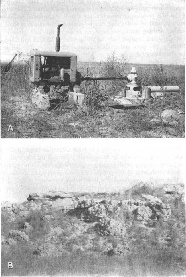
The irrigation wells in Lane County are equipped with deep-well turbine pumps. The pumps of four upland irrigation wells drilled in 1948 are operated by butane gas engines (Pl. 6A), and one is operated by a Diesel engine.
Other deep-well turbine pumps in the county are those used by the City of Dighton on their municipal wells. Electric motors are used to operate these pumps.
Plate 6--A, Deep-well pumping plant of B.U. Nichols in sec. 16, T. 17 S., R. 28 W. B, Mortar beds of Ogallala formation, SW NW sec. 1, T. 18 S., R. 28 W.; view looking east.
Prev Page--Occurrence, Water Table || Next Page--Utilization, Chemical Character
Kansas Geological Survey, Geology
Placed on web Jan. 18, 2008; originally published Sept., 1951.
Comments to webadmin@kgs.ku.edu
The URL for this page is http://www.kgs.ku.edu/General/Geology/Lane/05_gw2.html