![]()
Prev Page--Table of Contents || Next Page--Geography
Introduction
Purpose and Scope of the Investigation
The investigation upon which this report is based was begun in July 1948 as part of a program of ground-water studies in Kansas by the United States Geological Survey and the State Geological Survey of Kansas in cooperation with the Division of Sanitation of the Kansas State Board of Health and the Division of Water Resources of the Kansas State Board of Agriculture. Several similar investigations have been completed since this program was begun in 1937 and several are now being made in other areas in Kansas.
Ground water is one of the principal natural resources of Lane County as well as of much of the western half of Kansas. Nearly all public, domestic, railroad, and stock supplies are obtained from wells. Several irrigation wells were completed in Lane County in 1948, and it is probable that the use of ground water for irrigation will increase as new wells are drilled. At the present rate of withdrawal, the danger of seriously depleting the ground-water supply seems very slight, but there is a definite need for an adequate understanding of the quantity and quality of the available supply, where additional supplies can be obtained, and what measures may be necessary to safeguard their continuance.
The investigation was made under the general direction of A. N. Sayre, Geologist in Charge of the Ground-Water Branch of the United States Geological Survey; and under the immediate supervision of V. C. Fishel, District Engineer in charge of ground-water work in Kansas.
Location and Extent of the Area
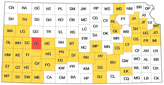
Lane County, on the eastern edge of the High Plains, is bounded on the north by Gove County, on the east by Ness County, on the west by Scott County, and on the south by Finney County. It is in the fourth tier of counties east of the western border of the State and is about midway between the north and south borders. It contains 20 townships, from T. 16 S. to T. 20 S. and from R. 27 W. to R. 30 W.; it has an area of 720 square miles. The location of this county and other areas in which cooperative ground-water investigations have been made are shown in Figure 1.
Fig. 1--Index map of Kansas showing area described in this report and areas covered by other online geologic reports, as of Jan. 2008. For additional information, please visit the KGS Geologic Maps of Kansas Page.
Previous Investigations
No detailed geologic reports on Lane County have been published previously, but several reports that apply to the county in a general way or in which the county has been referred to have been published. In 1897 Haworth (pp. 34-35) in a report on the physiography of western Kansas discussed Walnut Creek which rises in Lane County. In the same year Haworth contributed a report on the physical properties of Tertiary rocks in Kansas (1897a). A report of the Board of Irrigation Survey and Experiment to the State Legislature of Kansas for the years 1896 and 1897 also was published in 1897 and contained a log of and other information about a State-financed test well (Sutton, 1897). The same report contained a chapter on the geology of underground water in western Kansas in which several specific references were made to the geology and hydrology of Lane County (Haworth 1897b). In a report in 1897 on the Pleistocene of Kansas, Williston (1897, pp. 301-302, 304) made references to vertebrate fossils found in Lane County. In another report the same year he (Williston, 1897a) discussed the Niobrara formation of Kansas. Johnson (1901, 1902), in his reports on the utilization of the High Plains, made special reference to the source, availability, and use of ground water in western Kansas. In 1905 Darton (p. 306) published a preliminary report on the geology and ground-water resources of the central Great Plains in which he made brief reference to Lane County. A report on the quality of water supplies in Kansas published in 1911 by Parker contained analyses of waters from Lane County (p. 124) and made brief reference to the geology of Lane County (pp. 123-124, 290). A report by Coffey and Rice (1912) contains results of a reconnaissance soil survey in western Kansas, including Lane County. In a special report on well waters in Kansas, Haworth (1913) devoted a chapter to the Tertiary area of western Kansas.
In 1931, Elias, in a bulletin on the geology of Wallace County, Kansas, mentioned two localities in Lane County where he had found algal limestone capping exposures of the Ogallala formation (p. 141). Moss (1932, p. 8) made reference to the geology of Lane County in a report on Ness and Hodgeman counties. In a short report on the ground-water resources of the Shallow Water Basin in Scott and Finney counties, Moss (1933, p. 4) again briefly mentioned Lane County. In 1935 Theis, Burleigh, and Waite described the water-bearing formations and availability of ground water in the southern High Plains. A report on the geology and oil and gas resources of Logan, Gove, and Trego counties contained a graphic log of a test well drilled in Lane County (Landes and Keroher, 1939, Pl. 3). Latta (1944) made a study of the geology and groundwater resources of Finney and Gray counties, Finney bordering Lane on the south. In 1940 Moore and others prepared a generalized report on the ground-water resources of Kansas. In 1946 the State Geological Survey of Kansas published a subsurface geologic cross section that extended through Lane County (Maher, 1946). In 1939 and 1940 Waite did the field work for a report, published in 1947, on the geology and ground-water resources of Scott County, which adjoins Lane to the west. In 1949, Frye and Swineford published a discussion on the physiographic provinces in which Lane County is located. In 1949 a popular bulletin on the ground-water resources in southwestern Kansas was prepared by Frye and Fishel. In addition, several reports by Ver Wiebe contain paragraphs summarizing the results of test drilling done for oil and gas in Lane County (Ver Wiebe, 1938, p. 13; 1939, p. 105; 1945, p. 108; 1946, pp. 104-105; Ver Wiebe and others 1949, p. 100).
Methods of Investigation
Four months in the summer and fall of 1948 and two weeks in September 1949 were spent in the field collecting the data upon which this report is based. A total of 303 wells in the county were visited and the total depth and depth to water level were measured in most of them. Well owners and drillers were interviewed regarding the nature and thickness of water-bearing formations penetrated by the wells and all available logs were collected. Information regarding the yield, drawdown, temperature, chemical character, and use of ground water was obtained.
Samples of water from 30 representative wells were collected; they were analyzed in the Water and Sewage Laboratory of the Kansas State Board of Health at Lawrence by Howard A. Stoltenberg, chemist.
During the investigation the surficial geology was studied and the geologic map (Pl. 1) was prepared. To determine the character of the material beneath the surface, 33 test holes were drilled by William T. Connor, Kenneth L. Walters, and Max Yazza, using the portable hydraulic-rotary rig owned by the State Geological Survey. Samples from the test holes were collected and studied in the field by Mr. Walters and were later examined by me in the office with a binocular microscope. Logs of five irrigation wells and of several irrigation test holes were supplied by George Weishaar of the Weishaar and Son Drilling Company of Scott City.
Pumping tests on three irrigation wells (17-28-15cb, 17-28-22aaa, and 16-29-28dab) were made by Woodrow W. Wilson of the Federal Geological Survey. These tests were made to determine the yield of the wells and the permeability of the water-bearing materials. The altitudes of the surface at the test holes and of the measuring points of the wells were determined by C. K. Bayne and William A. Carlson, using a plane table and alidade. The water-table contour map (Pl. 1) is based upon these altitudes together with the measured depths to water level in these wells. Wells shown on this map and the depth to water map were located within the sections by use of the odometer. The base map used for Plates 1 and 2 was prepared by Woodrow W. Wilson from a county map compiled by the State Highway Commission of Kansas. Drainage was adapted from maps obtained from the United States Department of Agriculture, Soil Conservation Service. Geologic mapping was on a base map compiled by the State Highway Commission of Kansas. This field mapping was greatly aided by the use of aerial photographs supplied by the Soil Conservation Service and the Agricultural Adjustment Administration offices in Dighton. Frequent references to the geologic map of Kansas (Moore and Landes, 1937) were made during the mapping.
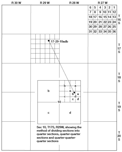
Well-numbering System
The well and test-hole numbers in this report give the location of wells according to General Land Office Surveys and according to the following formula: township, range, section, 160-acre tract within that section, the 40-acre tract within that quarter section, and the 10-acre tract within the quarter-quarter section if this subdivision can be accurately made. If two or more wells are within a 10-acre tract the wells are numbered serially beginning with the deepest well. An example of this well-numbering system is shown in Figure 2.
Fig. 2--Map of Lane County illustrating the well-numbering system used in this report.
Acknowledgments
I am indebted to many residents of Lane County who readily gave permission to measure their wells, and who supplied helpful data about them. Special thanks are extended to the owners of irrigation wells who permitted pumping tests to be made, and to George Weishaar of Scott City who furnished several logs of irrigation test holes and wells. Silas Stone, Soil Conservationist, Ralph F. Burrell, Agricultural Adjustment Administration Supervisor, and Warren J. Tillotson, retired rancher, supplied information concerning geology and ground water. Harold Biggs, well driller from Healy, also supplied additional information.
The manuscript for this report has been reviewed critically by several members of the Federal and State Geological Surveys; George S. Knapp, Chief Engineer, and Robert Smrha, Senior Engineer, of the Division of Water Resources of the Kansas State Board of Agriculture; and Dwight Metzler, Director, and Willard Hilton, Geologist, of the Division of Sanitation of the Kansas State Board of Health. The illustrations were drafted by Woodrow W. Wilson of the Federal Geological Survey.
Prev Page--Table of Contents || Next Page--Geography
Kansas Geological Survey, Geology
Placed on web Jan. 18, 2008; originally published Sept., 1951.
Comments to webadmin@kgs.ku.edu
The URL for this page is http://www.kgs.ku.edu/General/Geology/Lane/02_intro.html