![]()
Prev Page--Geography || Next Page--Ground-water Principles and Water Table
General Geology
Summary of Stratigraphy
Note: The classification and nomenclature of rock units used in this report are those of the State Geological Survey of Kansas and differ somewhat from those used by the U.S. Geological Survey.
The rocks that crop out in Kingman County are of sedimentary origin and range in age from Paleozoic to Cenozoic (Pl. 1). lie oldest rocks that crop out in the county are part of the Ninnescah Shale of the Leonardian Series, Permian System. The Ninnescah Shale crops out in the eastern part of the county and is exposed along the. valleys of South Fork of Ninnescah River and Chikaskia River where these streams have cut through younger deposits. The formation has one member, the Runnymede Siltstone, which occurs at the top. Above the Ninnescah is the Stone Corral Dolomite, which is a prominent marker bed in the subsurface to the west of Kingman County and is exposed in the north-central part of the county. In the southern part of the county the Stone Corral Dolomite is not recognizable, and its stratigraphic position is occupied by red dolomitic shale that cannot be distinguished from similar rocks below and above. The Harper Siltstone crops out in the central part of the county along South Fork of Ninnescah River and Chikaskia River, where it forms steep bluffs. The formation has two members, the Chikaskia Siltstone and the Kingman Siltstone. The youngest rocks of Permian age exposed in the county are part of the Salt Plain Siltstone and are poorly exposed near Chikaskia River in the Southwestern part of the county.
Unconsolidated deposits of silt, sand, and gravel believed to be a part of the late Pliocene Ogallala Formation of the Tertiary System unconformably overlie Permian rocks in the upland north and east of the city of Kingman. These rocks are poorly exposed along the valley walls of Smoots Creek and South Fork of Ninnescah River and are not known to be present in other parts of the county.
Cenozoic deposits of the Pleistocene Series unconformably overlie the Permian rocks in much of the county. These deposits range in age from the Holdrege Formation of the Nebraskan glacial stage to Recent alluvium and consist of unconsolidated clay, silt, sand, and gravel. They are present in the river valleys and mantle most of the upland surface of the county.
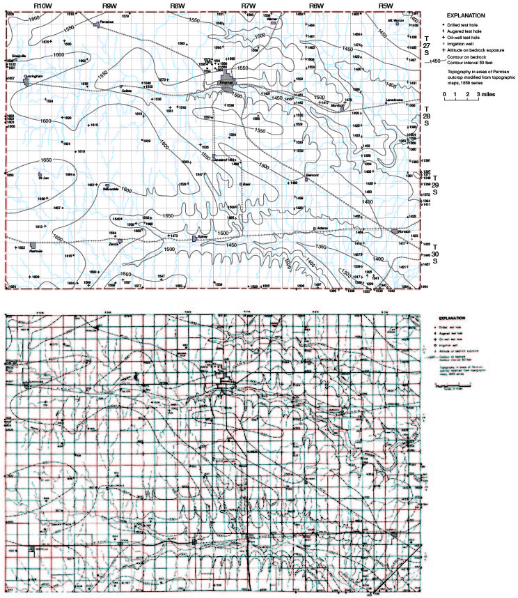
A generalized section of the outcropping rocks in Kingman County is given in Table 2. The configuration of the Permian bedrock surface is shown by means of contours in Figure 4, and geologic cross sections of the county are shown on Plate 2
Table 2--Generalized section of geologic formations in Kingman County and their water-bearing characteristics. The classification is that of the State Geological Survey of Kansas.
| System | Series | Subseries | Stage | Stratigraphic unit |
Member | Maximum thickness |
Physical character | Water supply |
|---|---|---|---|---|---|---|---|---|
| Quaternary | Pleistocene | Upper Pleistocene |
Recent | Alluvium | 30± | Silt, sand, and gravel in channels of major streams. Small areal extent. | Moderate to large water supplies may be obtained along rivers by induced filtration. | |
| Dune sand |
30± | Fine to medium sand and some silt. | Generally lies above the water table and yields no water to wells. | |||||
| Wisconsinan | Terrace deposits |
49 | Silt, sand, and gravel beneath terraces along present streams. | Moderate water supplies available for domestic and stock use. | ||||
| Peoria(?) Formation |
3 | Wind-deposited silt and fine sand occurring locally on upland divides. | Lies above the water table and yields no water to wells. | |||||
| Colluvium Recent to Illinoisan |
23 | Silt, sand, and some gravel deposited on slopes by sheet wash. | Yields small water supplies for domestic and stock use in small areas in eastern part of county. | |||||
| Sangamonian and Illinoisan |
Crete(?) Formation |
50 | Silt, sand, and gravel containing some caliche where on uplands. Forms terraces in eastern part of county. | Yields moderate water supplies for domestic and stock use where it forms terraces. | ||||
| Lower Pleistocene |
Yarmouthian and Kansan |
Sappa Formation |
Pearlette Ash bed |
150± | Silt, clay, sand, and gravel; locally contains volcanic ash. | Yield large water supplies adequate for irrigation in western part of county, moderate supplies for domestic and stock use in central part. | ||
| Grand Island Formation |
||||||||
| Aftonian and Nebraskan |
Fullerton Formation |
162 | Silt, clay, sand, and gravel; underlie Kansan deposits in western half of county. | Yield large water supplies where sufficient saturated thickness is present. | ||||
| Holdrege Formation |
||||||||
| Tertiary | Pliocene | Ogallala(?) Formation |
26 | Silt, sand, and gravel, locally derived. | Yields small water supplies for domestic and stock use in small area in county. | |||
| Permian | Leonardian | Nippewalla (Group) |
Salt Plain Siltstone |
265 | Reddish-brown siltstone, thin sandy siltstone, and fine-grained sandstone. | Buried beneath younger water-bearing deposits in most of western part of county and is not known to yield water to wells. | ||
| Harper Siltstone |
Kingman Siltstone |
80 | Brownish-red argillaceous siltstone and silty shale and a few thin beds of silty sandstone. | Yields small water supplies for domestic and stock use from weathered zone in central part of county. Wells often fail in drought periods. | ||||
| Chikaskia Siltstone |
130 | |||||||
| Sumner (Group) |
Stone Corral Dolomite |
0.4 | Grayish-buff coarse-textured dolomite; occurs only in north-central part of county. | Yields no water to wells. | ||||
| Ninnescah Shale |
Runnymede Siltstone |
4 | Brownish-red calcareous and dolomitic silty clay shale; some gray-green beds. Some thin beds of silty dolomite, limestone, and siltstone. | Yields small water supplies for domestic and stock use from deeply weathered zone in eastern part of county. | ||||
| 400 | ||||||||
Figure 4--Map of Kingman County showing configuration of Permian bedrock surface.
Geologic History
Paleozoic Era
During Paleozoic time marine rocks of Cambrian and Ordovician age were deposited in central Kansas over the igneous and metamorphic basement rocks. Rocks of Silurian and Devonian age were probably deposited over these older rocks and later removed by erosion after the pre-Mississippian uplift of the Ellis Arch (Central Kansas Arch). This ancestral arch extended from Chautauqua County on the Oklahoma line northwestward through Ellis County. Rocks of Mississippian age were deposited over the arch and lie unconformably on the Cambrian and Ordovician rocks. After deposition of Mississippian rocks the area was again raised and parts of the Upper Mississippian strata were deeply eroded. After this period of erosion the area was again submerged, forming the Sedgwick Basin where Pennsylvanian and Permian rocks about 3,500 feet thick were deposited. After the Permian rocks were deposited the area was again uplifted and subjected to a long period of erosion.
Mesozoic Era
The Mesozoic Era in Kansas is represented by rocks of the Triassic, Jurassic, and Cretaceous Systems. Central Kansas, including Kingman County, was probably a land area during Triassic and Jurassic time and no deposits of these periods are known in the area. Deposition was resumed in the area in Cretaceous time and a considerable thickness of Cretaceous rocks probably was deposited in Kingman County and removed by later erosion. No Cretaceous rocks crop out in the county or were penetrated in test drilling, but they are present to the west in Barber, Pratt, and Stafford counties.
Cenozoic Era
Tertiary Period
Uplift in the Rocky Mountain area and tilting of older rocks in adjacent areas at the close of the Mesozoic Era started a long period of erosion in which were removed all the Cretaceous and a part of the Permian sedimentary rocks from Kingman County and the surrounding area. Erosion was active until late Tertiary time, when deposits of the Pliocene Series were laid down. In Kingman County, silt, sand, and gravel, derived from Cretaceous and Permian rocks probably to the west and north, were deposited by streams on the gently sloping surface of the Permian rocks. These deposits are lithologically similar to the Pliocene rocks of McPherson County formerly called the "Delmore Formation" (Williams and Lohman, 1949) and are probably equivalent to them. Sediments of the late Pliocene Ogallala Formation may have been deposited over most of Kingman County and later removed by erosion. The Tertiary period ended with renewed but minor uplift in the Rocky Mountain area.
Quaternary Period--Pleistocene Epoch
After the physical disturbance that marked the end of the Tertiary Period there was a gradual climatic change in North America, which resulted in the formation of the great continental ice sheets and mountain glaciers that distinguish the Pleistocene Epoch. Four major ice sheets invaded the northern midcontinent region but did not reach as far south as south-central Kansas. The climatic changes that accompanied the ice invasions, however, resulted in erosion and deposition by streams fed in part by meltwater from the continental and mountain glaciers. These streams were responsible for the sculpturing of the present land surface over most of the state.
Nebraskan and Aftonian Stages
The surface of Kingman County at the beginning of Pleistocene time probably was a flat plain sloping gently to the southeast and mantled by thin Tertiary deposits. The climatic change that accompanied the formation and advance of the Nebraskan ice sheet into the midcontinent brought a cooler and moister climate to south-central Kansas than exists there today. Increased precipitation caused a period of downcutting by streams, and in Kingman County Nebraskan streams removed most of the Tertiary sediments and cut valleys as much as 100 feet into the Permian bedrock. By the time the Nebraskan ice sheet was at its maximum these streams were probably at base level and had gradients somewhat less than those of present major streams. The course of the Nebraskan streams in Kingman County can be delineated in a general way from the bedrock contour map (Fig. 4) and from the geologic cross-sections (Pl. 2). A trend toward a warmer climate and melting of the Nebraskan ice sheet brought about a change in the regimen of the Nebraskan streams, and they began to fill their valleys. Through drainage from the Rocky Mountain area did not cross south-central Kansas in Nebraskan time, and hence the Rocky Mountain area could not have been the source for the valley fill. Just west of Kingman County, however, the Ogallala Formation provided a readily available source of sediment in the headwater regions of the Nebraskan streams. The reasons for stream deposition at this time are not definitely known, but it seems probable that a decrease in precipitation resulted in decreased transporting power of the streams, and coupled with low stream gradients, caused widespread alluviation of the stream valleys. This process continued until the valleys were filled and many former divides were buried. As the Nebraskan ice front retreated from the midcontinent region and a milder climate returned to central Kansas, the once-powerful streams probably shifted laterally over wide areas, depositing progressively finer grained sediments and leaving a relatively flat, featureless plain sloping gently to the east and south. A long period of surface stability followed, and during this period, the Aftonian interglacial stage, soil formation was the dominant geologic process. Remnants of the Aftonian soil are present in parts of Kingman County.
Kansan and Yarmouthian Stages
The Aftonian interglacial stage was brought to a close by the return of a cooler, moister climate accompanied by the accumulation and advance of the Kansan ice sheet into the midcontinent region and heavy glaciation of the Rocky Mountain region. Increased precipitation caused a rejuvenation of streams and a period of downcutting in the major stream valleys. In Kingman County and much of the surrounding area there is little evidence of pronounced downcutting at this time, and the area may have been a low divide between major streams to the northeast and southwest. Through drainage by way of a stream originating in the Rocky Mountains probably was established in south-central Kansas by late Kansan time. The stream, heavily laden with outwash, rapidly filled its valley and, shifting laterally on its alluvial fill, topped the low divides and spread a thick sheet of alluvial material over most of the area. As the Kansan ice disappeared from the midcontinent and Rocky Mountain areas the stream carrying outwash into south-central Kansas from the mountains was shifting over an agradational plain of low gradient, depositing progressively finer material. As the Kansan Stage drew to a close with return of a milder climate, south-central Kansas was again a relatively flat plain sloping gently to the south and east, but at a higher altitude than existed at the close of the Aftonian (interglacial) Stage. A long period of surface stability followed during the Yarmouthian (interglacial) Stage, and soil formation again was the dominant geologic process. Remnants of the soil are preserved in extreme western Kingman County.
Illinoisan and Sangamonian Stages
Illinoisan time was begun by a return to a cooler climate and the accumulation and advance of the Illinoisan ice sheet into the northern midcontinent region and accumulation of glaciers in the Rocky Mountain area. The Illinoisan ice sheet did not extend farther south than southeastern Iowa, but the climatic changes accompanying continental glaciation were probably far reaching and caused the rejuvenation of streams in most of the midcontinent region. Major streams in northern Kansas once again deepened their valleys, but in most of south-central Kansas available evidence does not indicate that an integrated drainage system existed at the beginning of Illinoisan time west of the major stream flowing through the McPherson valley and the ancestral Arkansas River. Headward erosion of tributaries to the ancestral Arkansas River probably reached well into Kingman County during this time, establishing the pattern of the present drainage system in the county. With the melting of the Illinoisan ice and a return to a milder climate, outwash from the Rocky Mountains was again transported into south-central Kansas by a large stream. The stream shifted laterally, depositing a thin sheet of alluvial material over western Kingman County and the area farther west. This laterally shifting stream may have been captured by the headwaters of the ancestral Arkansas River during this time, establishing that river as the master stream in the area. A drainage adjustment of this nature would have far-reaching effects, and adjustment of the master stream to an increased volume of water and sediment would have renewed headward erosion of its tributaries at a time when streams in other parts of the state were alluviating their valleys. A major drainage change of this nature could account for the anomalous distribution of sediments tentatively dated as late Illinoisan, and for the drainage pattern, which does not yet seem to be stable.
During late Illinoisan time and early in the Sangamonian (interglacial) Stage that followed, eolian activity became effective in modifying the surface over much of Kansas. Strong winds began moving sand and silt from uplands where these materials were at the surface and not protected by vegetation and from stream valleys where annual floods probably spread fine material over flood plains. Sand was blown into dunes, which probably migrated short distances, and silt was carried many miles from its source and deposited as loess. Loess deposits of late Illinoisan age are not known to be present in Kingman County. A concentration of coarse gravel and pebbles a few inches thick overlying sediments of Kansan and Nebraskan age and underlying recent wind-blown material in some upland areas of the county indicate that Kingman County may have been a source area for loess deposited in surrounding areas at this time.
Surface stability prevailed over much of Kansas during much of Sangamonian time, and soil formation was the dominant geologic process. Remnants of the Sangamonian soil were not recognized in Kingman County. Surface conditions in the area may have precluded the development of a mature soil, or one may have been formed and later removed by erosion.
Wisconsinan Stage
The Wisconsinan is the youngest of the first-rank glacial stages and included several periods of glacial advance and retreat. Deposits of this stage, being younger than those of earlier stages, are better preserved and more extensively exposed and thus accessible for detailed study. The Bradyan (interglacial) Substage divides the Wisconsinan into two distinct periods in most of Kansas and is represented in much of the state by the Brady soil.
The Wisconsinan ice sheet advanced no farther south than central Iowa and northeastern Nebraska, but the change to a cooler and a moister climate that accompanied the accumulation and advance of the ice was far reaching and started a period of downcutting in most Kansas valleys. The major streams established in Kingman County in late Illinoisan time deepened their valleys and extended their drainage areas by headward erosion. When the return of a milder climate caused retreat of the early Wisconsinan ice, the streams were no longer able to transport their sediment load and alluviated their valleys. The Bradyan (interglacial) Substage that followed was a period of surface stability and soil formation. The Brady soil was not recognized in Kingman County but may be present near the surface of the stream terraces that are underlain by early Wisconsinan alluvium.
The return of a continental ice sheet to the northern mid-continent region in late Wisconsinan time resulted in deepening of most Kansas stream valleys. The major streams in Kingman County deepened their valleys about 25 feet below the level of the early Wisconsinan streams. With the retreat of the late Wisconsinan ice front and return of a more moderate climate, streams again alluviated their valleys. In Kingman County, as in much of Kansas, the deposits of early and late Wisconsinan age underlie terrace surfaces at two distinct levels adjacent to present streams. Eolian activity in early and late Wisconsinan time resulted in the deposition of loess on upland areas in much of Kansas. Thin deposits of sandy silt occur locally on upland divides in Kingman County and may in part be equivalent to the early Wisconsinan Peoria Formation.
Recent Stage
The Recent Stage represents the time since the late Wisconsinan ice sheet ceased to be an active force and includes about the last 10,000 years. The geologic processes responsible for the deposition of Recent sediments in Kingman County are those active in the area at the present time.
Prev Page--Geography || Next Page--Ground-water Principles and Water Table
Kansas Geological Survey, Geology
Placed on web Sept. 8, 2008; originally published March 1960.
Comments to webadmin@kgs.ku.edu
The URL for this page is http://www.kgs.ku.edu/General/Geology/Kingman/04_rock.html