![]()
Prev Page--Introduction || Next Page--Geology
Geography
Topography and Drainage
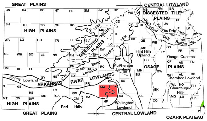
Kingman County is at the southeast edge of the Kansas portion of the Great Plains physiographic province as designated by Schoewe (1949). Approximately the western half is in the High Plains and Dissected High Plains sections. The eastern half is within the Red Hills division of the Dissected High Plains (Fig. 3). The general slope of the land surface is toward the southeast and averages 10 feet per mile. The highest points in the county are at the center of the western border and in the sand-dune area in the southwest corner. The altitude in these areas is about 1,800 feet above sea level. The lowest points in the county are where South Fork of Ninnescah River and Chikaskia River leave the county in the east-central and southeastern parts of the county and are about 1,340 feet above sea level.
Figure 3--Map of Kansas showing physiographic divisions. (From Schoewe, 1949).
Topographic relief in the county results from dissection by South Fork of Ninnescah River, which flows eastward across the northern third of the county, and by Chikaskia River, which parallels South Fork in the southern third of the county. The intervening terrain, ranging in width from 10 to 13 miles, forms a gently sloping divide across the county, which is dissected by many short tributary creeks near the rivers.
A second ridge extends southeastward from the northwestern part of the county to a narrow termination near the town of Murdock and forms the divide between South Fork of Ninnescah River and Smoots Creek, one of its major tributaries. In the northeastern corner of the county a poorly defined ridge forms the divide between Smoots Creek and North Fork of Ninnescah River. Along the southern border of the county on the south side of Chikaskia River is another ridge, which rises abruptly from the valley and reaches a crest about on the county line. This ridge forms the divide between Chikaskia River and Bluff Creek, one of its major tributaries, which drains most of Harper County.
Surface drainage of most of the county is good. A few square miles along the northern boundary northeast of the city of Kingman is flat and has poor surface drainage, and some land bordering the rivers is waterlogged. South Fork of Ninnescah River drains nearly all of the northern half of the county. Its main tributaries are Smoots Creek, which joins near the center of the eastern border of the county, and Painter Creek, which joins the main stream near the town of Calista. North Fork of Ninnescah River crosses the extreme northeast corner of the county but drains only a few sections in the county. Chikaskia River drains the southern half of the county; its major tributary is Sand Creek, which flows along the southern boundary of the county in the southwest corner and joins the main stream near the town of Spivey.
Climate
The climate of Kingman County is subhumid and is characterized by moderate precipitation, reasonably mild winters, and fairly hot summers. A large percentage of the winter days are clear, but snow flurries are common. Ordinarily snow remains on the ground only a short time. The weather during spring and fall is mild and very pleasant, but summers are generally hot, and strong southerly winds are common.
The climatic data in this report are compiled from records of the U. S. Weather Bureau. The normal annual precipitation at Norwich, based on a 62-year record, is 29.28 inches. The lowest annual precipitation of record at Norwich was 12.40 inches in 1956 and the highest of record was 48.84 inches in 1915. About 70 percent of the annual precipitation falls as rain during the growing season from April through September. January has the lowest normal monthly precipitation, 0.70 inch, and May has the highest, 4.51 inches. Much of the precipitation in Kingman County falls in relatively short, heavy thunderstorms. The greatest rainfall ever recorded at Norwich in a 24-hour period was 5.77 inches on April 8, 1927.
The normal annual temperature at Norwich is 57.9° F. The normal monthly temperature ranges from 33.3° F in January to 81.5° F in July. The highest temperature recorded was 117° F on August 12, 1936; the lowest temperature recorded was -21° F on February 13, 1905. The average date of the last killing frost in the spring is April 14, and the average date of the first killing frost in the fall is October 25. Killing frosts have occurred as late as May 15 and as early as September 20. The growing season averages 194 days but has been as long as 225 days and as short as 152 days.
Population
Kingman County was organized from parts of Harper and Reno counties on February 27, 1874, and had fewer than 20 settlers. In 1955 the county had a population of 10,857, of which 31 percent was urban [Note: Kingman County population was listed as 8,673 in 2000 U.S. census, with 36.8 urban (KU Institute for Policy & Social Research).]. Kingman, the largest town and the county seat, had a population of 3,741 in 1955 [3,387 in 2000]. Other communities and their 1955 population are Norwich, 413 [551 in 2000]; Spivey, 137 [80 in 2000]; Cunningham, 587 [514 in 2000]; Penalosa, 71 [27 in 2000]; Nashville, 143 [111 in 2000]; and Zenda, 183 [123 in 2000].
Transportation
Kingman County is served by about 110 miles of surfaced federal and state highways. U. S. Highway 54 crosses the northern half of the county from east to west, and Kansas Highway 42 crosses the southern half of the county from east to west. Kansas Highway 14 crosses the county from north to south near the center, and Kansas Highway 17 enters the county near the northeast corner and terminates at U. S. Highway 54. The southeast corner of the county is crossed by Kansas Highway 2. In addition, the county is served by about 120 miles of surfaced county roads. Most section-line roads in the county are open and are in good condition most of the year.
Transportation facilities provided by branch lines of the Atchison, Topeka and Santa Fe Railway and the Missouri Pacific Railroad are good. These railroads pass through almost all the towns, and few farms in the county are more than 7 miles from the nearest railroad.
Agriculture
According to the State Board of Agriculture, the number of farms in Kingman County in 1955 was 1,320 and the total acreage under cultivation was about 282,000, mostly devoted to the production of grain [830 farms and 550,000 acres in 2005, (KU Institute for Policy & Social Research)]. The acreages of the principal crops harvested in 1955 are shown in Table 1.
Table 1--Acreage of principal crops harvested in Kingman County in 1955
| Crop | Acreage harvested |
|---|---|
| Wheat | 114,000 |
| Sorghums | 59,100 |
| Hay | 22,300 |
| Oats | 13,000 |
| Barley | 10,000 |
| Corn | 2,400 |
| Rye | 2,000 |
Livestock raising also is an important agricultural pursuit in Kingman County. In 1955 the livestock on farms included 6,200 cows, 44,200 other cattle, and 5,650 hogs.
Mineral Resources
The mineral resources of Kingman County include oil, gas, helium, salt, sand, gravel, and volcanic ash.
Oil and gas--Oil and gas are important mineral resources in Kingman County. Oil was discovered in the county in January 1926 in sec. 6, T. 27 S., R. 7 W., when a well 3,853 feet deep was completed in the uppermost part of the "Mississippi lime" for an initial production of 120 barrels a day. Development in the county has continued and in 1958 oil and gas were being produced from twenty-seven fields, which had yielded 14.3 million barrels of oil and 35.4 billion cubic feet of gas. The cumulative production, the number of wells, the producing zones, and the depth of production for all fields in the county are given in annual reports by the State Geological Survey of Kansas on oil and gas developments. [For current information on oil and gas production, see the Survey's oil and gas page for Kingman County.]
Helium--Helium is present in small quantities in natural gas produced from the Cunningham pool in western Kingman County and eastern Pratt County. During World War II an extraction plant was built by the U. S. Government near Cunningham to help meet the wartime demand for helium. The plant began operation on January 17, 1944, and operating continuously until July 9, 1945, produced 43 million cubic feet of helium. The extraction plant was dismantled shortly thereafter, and helium is not currently being produced in the county.
Salt--Salt deposits of the Wellington Formation of Permian age underlie all of Kingman County and range in thickness from about 250 feet in the eastern part of the county to 450 feet in the southwestern part. The salt beds are interstratified with thin beds of shale, anhydrite, and limestone, but many beds of minable thickness are present. These deposits of salt underlie most of south-central Kansas and were laid down in Permian seas that were partly cut off from the ocean.
During the early days of the salt-producing industry in Kansas, two mines were in operation at Kingman. The first mine began operation in 1889 but closed about 2 years later. A second mine was opened shortly thereafter but ceased operation in 1893. Huge salt reserves are present but salt is not being produced in the county.
Sand and gravel--Sand and gravel are obtained in Kingman County from Pleistocene deposits in the valleys of South Fork of Ninnescah River and Chikaskia River. Extensive deposits of sand and gravel are also available in the uplands in much of the county. The sand and gravel are used for concrete aggregate and for road surfacing.
Volcanic ash--Two small deposits of volcanic ash are known in Kingman County. A 2-foot bed of ash caps a small rise in the NW NE sec. 16, T. 29 S., R. 10 W., about a quarter of a mile west of St. Leo. Another deposit of unknown size is reported in the SW NW sec. 30, T. 28 S., R. 7 W. Both deposits are too small to be of commercial value but may be useful locally as a ceramic material. Other deposits of volcanic ash may be present in the uplands of the western part of the county but probably would require much prospecting to locate.
Prev Page--Introduction || Next Page--Geology
Kansas Geological Survey, Geology
Placed on web Sept. 8, 2008; originally published March 1960.
Comments to webadmin@kgs.ku.edu
The URL for this page is http://www.kgs.ku.edu/General/Geology/Kingman/03_geog.html