![]()
Prev Page--Contents || Next Page--Geography
Introduction
Purpose and Scope of Investigation
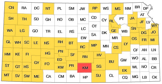
The investigation upon which this report is based is part of a continuing program of ground-water investigations in Kansas begun in 1937 by the United State Geological Survey and the State Geological Survey of Kansas in cooperation with the Division of Sanitation of the Kansas State Board of Health and the Division of Water Resources of the Kansas State Board of Agriculture. The present status of the program is shown in Figure 1.
Figure 1--Index map of Kansas showing area described in this report and areas covered by other online geologic reports, as of Sept. 2008. For additional information, please visit the KGS Geologic Maps of Kansas Page.
The investigation of the geology and ground-water resources of Kingman County was made to determine the availability and quality of ground water for domestic, stock, municipal, industrial, and irrigation use and to determine the geologic and hydrologic factors that control the occurrence of ground water in the county. Ground water is one of the county's principal natural resources, and though supplies are adequate in most of the county at the present withdrawal rate, there is a need for better understanding of the quantity and quality of the available water supply to meet anticipated population increases and expanding use by industry and agriculture.
Location and Extent of Area
Kingman County, in south-central Kansas, is bounded on the north by Reno County, on the east by Sedgwick and Sumner counties, on the south by Harper and Barber counties, and on the west by Pratt County. It includes 24 townships and has an area of about 864 square miles. The location of the county is shown in Figure 1.
Previous Investigations
A detailed study of the Quaternary geology and ground-water resources of Kingman County has not been made previously. Williams and Lohman (1949), described the geology and ground-water resources of an adjacent part of south-central Kansas. Carey and others (1952) reported the occurrence of volcanic ash in the county. Frye and Leonard (1952) reported the occurrence of early Pleistocene sediments in the county and described fossil mollusks from these deposits. Hibbard (1956, 1957) and Tihen (1955) described vertebrate fossils from these deposits. The geology and groundwater resources of bordering Reno County were described by Bayne (1956), Sumner County by Walters (in preparation), and Harper County by Bayne (1960).
The Permian rocks of south-central Kansas, including Kingman County, were described by Norton (1939) and Swineford (1955). Moore (1920), Moore and Landes (1937), Lee (1949), and Moore and others (1951) described parts of the general geology of south-central Kansas.
Methods of Investigation
Field work was begun in Kingman County in April 1955. Additional field work was done during the spring and summer of 1956. Data were collected on 79 wells and included the depth of the well and depth to water in the well. Data concerning yield, adequacy of the supply, and quality of the water were obtained from well owners. A total of 235 test holes were drilled in the' county to determine the thickness and character of the Quaternary deposits. Of the test holes, 36 were drilled with a hydraulic rotary drilling machine and 199 with a jeep-mounted power auger, both owned by the State Geological Survey of Kansas. Samples of drill cuttings were collected and examined in the field and later examined microscopically in the laboratory. Well contractors operating in the county provided logs of 12 test holes and 7 wells. Locations of wells and test holes within the sections were determined by means of an odometer, and the altitudes of measuring points of wells and test holes were determined with a plane table and alidade.
The stage of South Fork of Ninnescah River and its tributaries was measured at 14 points and of Chikaskia River and its tributaries at 11 points to aid in the preparation of the water-table contour map of the county (Pl. 3).
Samples of water were collected from 21 wells, from 2 springs, and from 1 point on South Fork of Ninnescah River and 1 on Chikaskia River and were analyzed by Howard A. Stoltenberg, chemist, in the Water and Sewage Laboratory of the Kansas State Board of Health.
Geologic mapping was done on aerial photographs obtained from the Agricultural Adjustment Administration, U. S. Department of Agriculture, and later transferred to base maps using a focalmatic projector for reduction. The base maps used for Plates 1, 2, and 3 were compiled from maps prepared by the Soil Conservation Service. The roads were corrected in the field, and the drainage was delineated from aerial photographs.
Well-numbering System
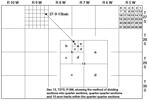
The well numbers used in this report show the location of each well according to General Land Office surveys of the area, in accordance with the following formula: Township, range, section, quarter section, quarter-quarter section, and quarter-quarter-quarter section (10-acre tract). When two or more wells fall within the same 10-acre tract they are numbered serially according to the order in which they were inventoried. The quarter sections, quarter-quarter sections, and 10-acre tracts are designated a, b, c, and d in a counterclockwise direction, beginning in the northeast quarter. For example, well 27-9-13bab, (Fig. 2) is in the NW NE NW sec. 13, T. 27 S., R. 9 W.
Figure 2--Outline map of Kingman County illustrating well-numbering system used in this report.
Acknowledgments
Thanks and appreciation are expressed to the many residents who supplied information on their wells and to those who allowed access to their property for the study of rock exposures, to the officials of cities who provided information concerning city water supplies, and to the drilling contractors who supplied logs of wells and test holes drilled in the county. Special acknowledgment is made to Dr. Claude W. Hibbard, Curator of Vertebrates, University of Michigan Museum of Paleontology, for his assistance in the collection and preparation of fossils from Kingman County and for his identification of the vertebrates; and to Dr. Dwight W. Taylor, of the U. S. Geological Survey, for his identification of the fossil mollusks.
The manuscript of this report has been reviewed by members of the U. S. Geological Survey and the State Geological Survey of Kansas; by Messrs. R. V. Smrha, Chief Engineer, and George S. Knapp, Engineer, of the Division of Water Resources of the Kansas State Board of Agriculture; and by Messrs. Russell L. Culp, Chief, Water Supply Section, and Willard O. Hilton, Geologist of the Division of Sanitation, of the Kansas State Board of Health.
Prev Page--Contents || Next Page--Geography
Kansas Geological Survey, Geology
Placed on web Sept. 8, 2008; originally published March 1960.
Comments to webadmin@kgs.ku.edu
The URL for this page is http://www.kgs.ku.edu/General/Geology/Kingman/02_intro.html