![]()
Prev Page--Recovery || Next Page--Quality
Ground Water, continued
Utilization of Water
Most of the wells in Grant, Haskell, and Stevens Counties supply or have supplied water for domestic and stock use. Much of time water pumped from wells in this area is used for irrigation, although only a small percentage of the wells are used for this purpose. Many wells have been drilled to supply water for use in drilling gas wells, but these generally are abandoned as soon as the gas well has been completed. A few wells are used for public-water supplies and for railroads.
Domestic and Stock Supplies
Domestic wells supply water in homes for drinking, cooking, and washing, and in schools other than those supplied by municipal wells. Stock wells supply water for livestock, principally cattle and sheep that are pastured on winter wheat. Most of the domestic and stock wells are small-diameter drilled wells equipped with lift or force pumps operated by windmills or by hand. In the valleys where the water table is shallow, a few domestic and stock wells are dug or driven. The water used for domestic and stock supplies is moderately hard but generally is satisfactory. Much of the ground water in northern Stevens County and in western Grant County contains sufficient fluoride to be injurious to children's teeth during the period of their formation (see Quality of Water).
Public Supplies
The cities of Ulysses, Sublette, Satanta, Hugoton, and Moscow have municipal water supplies derived from wells.
Ulysses--Ulysses (population, 824, according to 1940 census) is supplied by two wells (52 and 53) which obtain water from the Rexroad (?) and Meade formations. The wells are said to be 290 feet deep and are cased with 12-inch wrought-iron casing. Each well is equipped with a turbine pump powered by a natural-gas engine. Well 52 is reported to yield 200 gallons a minute with a drawdown of 28 feet; well 53 is reported to yield 150 gallons a minute, but there is no record of the drawdown. Water is pumped from the wells directly into the mains, the excess water going into the 75,000-gallon elevated steel storage tank in the city park. No data on the consumption of water were available. The water is moderately hard and contains 1.7 parts per million of fluoride which is considered sufficient to cause very slight mottling of children's teeth. (See analysis 52, Table 11.)
Sublette--The water supply of Sublette (population, 582) is obtained from two wells (183 and 184) within the city limits. Well 183, which is near the depot of the Atchison, Topeka and Santa Fe Railway Company, is 290 feet deep and is reported to have a static water level 201 feet below land surface. The well is cased with 6-inch wrought-iron casing and is equipped with a turbine pump powered by an electric motor. The yield of the well is reported to be 100 gallons a minute. Well 184, which is near the elevated reservoir, is 275 feet deep and has a static water level of about 202 feet.
It is a 24-inch gravel-walled well cased with wrought-iron casing and is equipped with a turbine pump powered by an electric motor. The reported yield of this well is 175 gallons a minute on open flow at land surface and 150 gallons when the water is pumped into the mains.
Water is pumped from the wells directly into the 4-inch mains, the excess water going into an elevated steel storage tank having a capacity of 20,000 gallons. The water is moderately hard but is suitable for most domestic uses. (See analysis 183, Table 12.)
Satanta--Satanta (population, 345) is supplied by two wells (218, 219) which obtain water from the Rexroad (?) formation and perhaps in part from the Laverne formation. The wells are near the municipal swimming pool in the northern part of town; they are reported to be 280 feet deep and to have a static water level of 200 feet. Each well is cased with 8-inch wrought-iron casing and is equipped with a turbine pump powered by an electric motor. Well 218 is reported to yield 150 gallons a minute. Well 219 is reported to yield 325 gallons a minute when the water is discharged at land surface and 250 gallons a minute when the water is discharged into the mains. The drawdown of this well is reported to be 40 feet when it is being pumped at the rate of 325 gallons a minute.
Water is pumped from the wells directly into the 4- and 6-inch mains, the excess water going into an elevated steel storage tank having a capacity of 50,000 gallons. The water is moderately hard, but otherwise is of good quality. (See analysis 218, Table 12.)
Hugoton--The water supply of Hugoton (population, 1,349) is obtained from two wells (296 and 297) which penetrate Tertiary and Quaternary deposits. Well 296 is a gravel-walled well drilled to a depth of 308 feet (log 52) and has a static water level of 80 feet. It is cased with 12-inch wrought-iron casing and has 40 feet of screen set opposite the coarser water-bearing materials. The coarsest water-bearing materials were found between the depths of 248 and 267 feet. The well is equipped with a turbine pump powered by an electric motor, and is reported to yield 130 gallons a minute with a drawdown of 80 feet after 30 hours of pumping.
Well 297 (log 53), which is in the city park, is a gravel-walled well drilled to a depth of 300 feet and has a static water level of 85 feet. It is cased with 18-inch wrought-iron casing and has 80 feet of slotted screen set at various intervals between the depths of 88 and 300 feet. The well is equipped with a turbine pump powered by an electric motor, and it yields 230 gallons a minute with a drawdown of 160 feet after 28 hours of pumping.
Water is pumped from the wells directly into the mains, which range in diameter from 4 to 6 inches. The excess water is stored in two reservoirs, one underground and the other elevated, the aggregate capacity of which is 285,000 gallons. The average daily consumption of water in Hugoton in 1941 was 126,847 gallons. The water is moderately hard but otherwise is of good quality. The fluoride content is within the safe limit discussed under Quality of Water. (See analysis 296, Table 13.)
Moscow--Moscow (population, 177) is supplied by a well (239) which penetrates Tertiary and Quaternary deposits. The well is reported to be 290 feet deep and to have a static water level of 140 feet. It is cased with 6-inch oil-well casing and is equipped with a 3-inch lift pump powered by a 5-horsepower electric motor. The reported yield of the well is 10 gallons a minute.
Water is pumped from the well directly into the 2-inch mains, the excess water going into a steel storage tank having a capacity of 27,500 gallons. The water contains 1.2 parts per million of fluoride which is considered sufficient to cause very slight mottling of some children's teeth. (See analysis 239, Table 13.)
Railroad Supplies
The Atchison, Topeka and Santa Fe Railway Company has four wells in Grant, Haskell, and Stevens Counties that are used for railroad supplies (54, 182, 216, and 295). In addition, they have one well at Moscow (238), which was formerly used for railroad supply. (See logs 47, 48, 49, 50, and 51.) The wells range in depth from 182 to 334 feet and the depths to water level range from 50 feet at Ulysses to 220 feet at Satanta. The wells are cased with wrought-iron casing and most of them are equipped with lift pumps. The well at Hugoton is equipped with a deep-well turbine pump.
Industrial Supplies
Many wells have been drilled in Grant, Haskell, and Stevens Counties to supply water for use in drilling gas wells. Most of these wells are abandoned after completion of the gas well, but a few have been sold to farmers who now use them for watering stock. These wells generally penetrated much of the Tertiary and Quaternary water-bearing materials and ranged in depth from about 200 feet to more than 400 feet. They were cased with 8- or 10-inch wrought-iron casing and generally were equipped with cylinder or with air-lift, pumps. Data concerning their yields and drawdowns were not available, but it was reported that a few of these wells yielded as much as 500 gallons a minute.
Possibilities of Further Development of Industrial Supplies from Wells
Abundant supplies of natural gas and ground water are available in Grant, Haskell, and Stevens Counties for the development of industries. This area is underlain by thick deposits of saturated material that would yield moderate to large quantities of water to wells (Pl. 3). Industrial wells could be developed in almost any part of the area provided preliminary test holes penetrated an adequate thickness of coarse water-bearing material. The area in which industrial supplies could be developed is much larger than the area in which irrigation supplies could be developed, because industry would not be as limited as irrigation by the type of soil and by pumping lift (Fig. 16). There are large areas in Stevens County, for example, where sandy soil and irregular topography prevent the development of irrigation but where industrial wells could be constructed. This is also true in the dune-sand area in northern Grant and Haskell Counties.
Figure 16--Map of Grant, Haskell, and Stevens counties showing areas most favorable for development of irrigation.
Irrigation Supplies
Prior to the extended drought between 1931 and 1940 there was little or no irrigation with water from wells in this area except from one shallow well (46) in Lakin Draw northeast of Ulysses. The repeated crop failures after 1931 stimulated interest in irrigation in this area so that in 1943 there were 20 irrigation wells, 14 of which were in Grant County. Although the precipitation has been above normal since 1940, the interest in irrigation has continued, particularly in the area of shallow water northwest of Ulysses where experiments have been made in the irrigation of potatoes, onions, and melons.
The records of all the irrigation wells in this area visited during the field investigation are given in Tables 18, 19, and 20 and the locations of the wells are shown on Plate 2. The area that was reported to have been irrigated in 1942 comprised 1,744 acres from 13 wells in Grant County, 61 acres from two wells in Haskell County, and 472 acres from four wells in Stevens County. This survey of irrigated acreage was made by Woodrow W. Wilson in April 1943. Data on the quantity of water pumped for irrigation in 1942 are not available; however, six of the wells were reported to have pumped 1,030 acre-feet of water to irrigate 668 acres of land. This is equivalent to about 1.5 acre-feet of water for each acre of land. Similarly, according to the U.S. Census, the average quantity of water used in western Kansas in 1939 to irrigate one acre of land was 1.5 acre-feet. If it is assumed that 1.5 acre-feet of water was used for each irrigated acre of land in Grant, Haskell, and Stevens Counties in 1942, then the quantity of water pumped for irrigation during that year would be about 3,500 acre-feet.
The annual pumpage for irrigation in this area varies with the precipitation, but prior to the end of 1943 the pumpage increased each year because of the increase in number of pumping plants and in irrigated acreage. In 1944, however, the pumpage decreased because of abundant precipitation and the scarcity of farm labor.
Yields of irrigation wells--The yields of 10 irrigation wells in Grant, Haskell, and Stevens Counties were determined by pumping tests, the results of which are given in Table 8.
Table 8--Pumping tests of irrigation plants in Grant, Haskell, and Stevens Counties (1).
| Well No. | Drawdown (feet) |
Discharge (gallons a minute) | |
|---|---|---|---|
| Total | Per foot of drawdown | ||
| 29 | 23.20 | 1,184 | 51.03 |
| 30 | 19.85 | 1,098 | 55.31 |
| 21.85 | 1,117 | 51.12 | |
| 22.82 | 1,120 | 49.08 | |
| 23.40 | 1,130 | 48.29 | |
| 23.95 | 1,132 | 47.27 | |
| 24.21 | 1,124 | 46.43 | |
| 24.57 | 1,118 | 45.50 | |
| 31 | (2) | 967 | |
| (2) | 994 | ||
| 56 | (2) | 995 | |
| (2) | 932 | ||
| (2) | 909 | ||
| 30.20 | 878 | 29.07 | |
| 35.80 | 869 | 24.27 | |
| 36.80 | 848 | 23.04 | |
| 37.30 | 836 | 22.47 | |
| (2) | 825 | ||
| 60 | 31.17 | 1,435 | 46.04 |
| 92 | 17.91 | 452 | 25.24 |
| 21.25 | 459 | 21.60 | |
| 23.05 | 455 | 19.74 | |
| 24.17 | 458 | 18.95 | |
| 24.98 | 459 | 18.37 | |
| 25.45 | 453 | 17.80 | |
| 115 | 23.23 | 652 | 28.07 |
| 23.11 | 557 | 24.10 | |
| 23.74 | 536 | 22.58 | |
| 23.70 | 768 | 32.40 | |
| 23.64 | 746 | 31.56 | |
| 23.29 | 756 | 32.46 | |
| 23.23 | 750 | 32.29 | |
| 244 | 12.72 | 1,100 | 86.48 |
| 11.73 | 1,060 | 90.37 | |
| 12.09 | 1,070 | 88.50 | |
| 12.38 | 1,080 | 87.24 | |
| 12.66 | 1,020 | 80.57 | |
| 13.10 | 1,100 | 83.97 | |
| 13.17 | 1,160 | 88.08 | |
| 13.36 | 1,148 | 85.93 | |
| 247 | 12.74 | 1,297 | 101.81 |
| 13.58 | 1,312 | 96.61 | |
| 14.15 | 1,318 | 93.14 | |
| 14.34 | 1,324 | 92.33 | |
| 14.48 | 1,324 | 91.44 | |
| 15.64 | 1,355 | 86.64 | |
| 15.22 | 1,350 | 88.70 | |
| 299 | 15.35 | 614 | 11.96 |
| 66.71 | 600 | 8.99 | |
| 75.12 | 570 | 7.59 | |
| 79.97 | 561 | 7.02 | |
| 83.59 | 547 | 6.54 | |
| 86.79 | 544 | 6.27 | |
| 88.83 | 536 | 6.03 | |
| 90.48 | 526 | 5.81 | |
| 91.45 | 526 | 5.75 | |
| 93.67 | 520 | 5.55 | |
| 94.64 | 524 | 5.54 | |
1. Pumping tests made by the Division of Water Resources of the Kansas State Board of Agriculture in cooperation with the State and Federal Geological Surveys. Wells 30, 92, 115, 244, 247, and 209 were tested by Melvin Scanlan and W.W. Wilson; wells 29, 3
2. No drawdown measurement available.
The wells that were tested were deep wells equipped with turbine pumps powered by gasoline, diesel, or natural-gas engines. Measurements of yield were made using a Collins flow gage (Pl. 8). An electrical contact device and a steel tape or both were used for measuring the drawdowns in the wells while pumping, and a steel tape was used for all water-level measurements after pumping stopped. The yields of the wells ranged from 452 to 1,435 gallons a minute; the drawdowns in nine of the wells ranged from 11.73 to 94.64 feet, and the specific capacities ranged from 5.5 to 101.8. Well 145, for which no discharge measurements are available, was reported to yield 800 gallons a minute with a measured drawdown of 6.26 feet. If the reported yield is correct, the specific capacity of the well is 128, which is the highest that has been reported or measured in this area.
Construction of irrigation wells--The irrigation wells in Grant, Haskell, and Stevens Counties are of one type. They are deep wells that penetrate all or most of the water-bearing materials above the Dakota formation. Most of the wells are gravel-wailed wells cased with 16-inch wrought-iron casing and equipped with deep-well turbine pumps powered by natural-gas engines. Some of the wells penetrate water-bearing formations so fine-grained that the wells should be gravel-packed in order to keep out the sand and obtain larger yields (see p. 68). In order to obtain an efficient well, it is essential to use proper size gravel and proper size screens or perforations. Gravel-packing adds to the cost of construction and should be used only where water in satisfactory quantities can be obtained in no other way and then only after a thorough study of the water-bearing material to determine the proper size of gravel to be used and, therefore, the proper slot size of screen or perforation of casing. For detailed descriptions of gravel-packing, the reader is referred to Rohwer (1940), Bennison (1943), and Davison (1939).
Depth and diameter of irrigation wells--The irrigation wells in Grant, Haskell, and Stevens Counties, except well 46 which is abandoned, range in depth from 112 feet to 375 feet, and the diameters range from 12 to 18 inches (Table 9).
Table 9--Depths and diameters of irrigation wells in Grant, Haskell, and Stevens Counties.
| Depth (feet) | Number of wells |
|---|---|
| 100-200 | 2 |
| 201-300 | 12 |
| 301-400 | 6 |
| Total | 20 |
| Diameter (inches) | Number of wells |
| 12 | 2 |
| 16 | 15 |
| 18 | 3 |
| Total | 20 |
Types of irrigation pumps--All the irrigation wells in Grant, Haskell, and Stevens Counties are equipped with deep-well turbine pumps, most of which have 6-inch or 8-inch discharge pipes. Well 46 in Lakin Draw is equipped with a centrifugal pump, but this well has been abandoned.
Irrigation pump power--Engines using natural gas for fuel operate about half of the pumps on irrigation wells in this area. The remainder are operated by gasoline or diesel engines (Table 10). There are very few electric power lines near irrigation wells in this area, but all the wells except 134 and 145 are within the limits of the Hugoton gas field; hence there is an abundance of low-priced fuel available to irrigation plants. Data on the consumption of natural gas (determined by pumping tests conducted by Kenneth D. McCall, Melvin Scanlan, and Woodrow W. Wilson) by four pumping plants in Grant and Stevens Counties (30, 56, 244, and 247) indicate a cost of fuel of 0.28 cent per acre-foot of water per foot of lift. The average lift in the four wells was 95 feet, the average discharge was 1,100 gallons a minute, and the average cost of fuel per acre-foot of water was $0.27. Most of the power units on irrigation wells in this area are belted to the pump pulleys, but a few are direct-connected to the shafts.
Table 10--Type of power used for operating irrigation pumps in Grant, Haskell, and Stevens Counties.
| Type of Power | Number of wells |
| Diesel engine | 2 |
| Gasoline engine | 8 |
| Natural-gas engine | 10 |
| Total | 20 |
Possibilities of Further Development of Irrigation Supplies from Wells
The feasibility of further development of irrigation supplies from wells is dependent upon the safe yield of the ground-water reservoir (the amount of water that can be withdrawn annually over a long period of years without depletion), the cost of drilling and pumping, the types of soil, the quality of water, the kinds of crops raised, the market and price conditions, and perhaps other factors. The ability of an underground reservoir to yield water over a long period of years is limited, as is that of a surface reservoir. If water is withdrawn from an underground reservoir by pumping and by other means (seeps, springs, evaporation, and transpiration) faster than water enters it, the supply will be depleted and the water levels in wells will decline. The amount of water that can be withdrawn annually over a long period of years without depletion of the ground-water reservoir is dependent upon the capacity of the underground reservoir and upon the amount of water that is added annually to the reservoir by recharge.
The cost of drilling and pumping is determined in part by the depth to water level. In areas where the water level is relatively deep the wells must be deep and the pumping lift is great. The cost of a well is also determined in part by the permeability and the thickness of the water-bearing materials. Wells may encounter relatively fine-grained materials that cause the yield of the well to be relatively small. Gravel-packing may increase the yield, but it also adds to the cost. The character of the soil and the contour of the land surface also are important factors. The soil may be too sandy, as it is in many parts of Stevens County, or the land may be poorly drained, as it is in parts of northwestern Grant County and in much of the dune-sand area in Stevens County.
Grant, Haskell, and Stevens Counties are underlain by thick deposits of water-bearing silt, clay, sand, and gravel. An irrigation well could be developed in almost any part of the area provided preliminary test drilling indicated an adequate thickness of water-bearing sand and gravel. Among the chief factors limiting the development of irrigation in this area are depth to water, condition of soil, and surface slope. The depth to water level in much of Grant, Haskell, and Stevens Counties is so great that irrigation from wells is not economically feasible. The depth to water level beyond which pumping from wells for irrigation is too costly is difficult to determine and is variable. The limit may be influenced by type of crop grown, quality of the soil, price of crops, climate, cost of fuel, and drawdown of the well. Well 299, for example, has a pumping lift of more than 177 feet, although the static water level is only 82.8 feet. Well 145, however, has a static water level of 161.4 feet but the pumping lift is only 167.7 feet. (For a discussion of cost of pumping, the reader is referred to McCall and Davison, 1939, and McCall, 1944.) In the discussion of the possibilities of further development of irrigation, only those areas are considered where the depth to water level is less than 100 feet. This is an arbitrary limit and may be altered by various conditions as stated above. In addition, as pumping equipment is improved the economic limit of pumping lifts may increase. In 1943, there were six irrigation wells in this area having a static water level greater than 100 feet and seven irrigation wells having a pumping lift greater than 100 feet.
The shallow-water areas in Grant, Haskell, and Stevens Counties are very similar to the irrigation area near Plainview and Hereford in the panhandle of Texas. Both areas are a part of the High Plains, are underlain by thick deposits of Tertiary or Quaternary sediments or both, have a similar climate, and have almost equal depths to water level. According to White, Broadhurst, and Lang (1940) there were approximately 1,700 irrigation wells in the High Plains of Texas in 1939 which were used to irrigate about 230,000 acres of land. In 1940, there were about 2,100 irrigation wells in the area. It is believed that irrigation could be developed profitably in the areas of shallow water in Grant, Haskell, and Stevens Counties. Many irrigation wells in the High Plains of Texas have static water levels greater than 100 feet; hence it is believed that water could be pumped economically in the areas in Grant, Haskell, and Stevens Counties where the depth to water is less than 100 feet. Inasmuch as all the potential irrigation areas in Grant and Stevens Counties are within the limits of the Hugoton gas field where there is an abundance of low-priced fuel, it is believed that water could be pumped more economically here than in the High Plains of Texas.
The Grant-Haskell-Stevens area also is very similar to the large irrigation area in Scott County, Kansas. The areas have similar climate and geology except that the water-bearing materials generally are much thicker in the Grant-Haskell-Stevens area. The cost of fuel per acre-foot of water per foot of lift in Grant, Haskell, and Stevens Counties is much less than it is in Scott County because of the low cost of natural gas in the Hugoton gas field. The average cost of natural gas per acre-foot of water per foot of lift in four irrigation plants tested in Grant and Stevens Counties was 0.28 cent. The average cost of fuel per acre-foot of water per foot of lift in 27 plants tested in Scott County was 0.96 cent for 12 plants using natural gas and 2.7 cents for 15 plants using electricity (McCall, 1944, pp. 25-30). The average lift in the four wells in Grant and Stevens Counties was 95 feet, whereas the average lift in the 27 plants in Scott County was 83 feet.
The cost of fuel for pumping water for irrigation also seems to be less in the vicinity of the Hugoton gas field than in any other upland area in southwestern Kansas. The Division of Water Resources of the Kansas State Board of Agriculture tested 22 deep-well pumping plants in southwestern Kansas in 1938 (Anon., 1938) and found that the average cost of fuel per acre-foot of water per foot of lift was 1.07 cents in plants using natural gas, 2.90 cents in plants using gasoline, 2.18 cents in plants using distillate, and 2.69 cents in plants using electricity. The average lift in these wells was 98.7 feet. As stated above, the average cost of fuel per acre-foot of water per foot of lift in four plants that were tested in Grant and Stevens Counties was 0.28 cent. It must be remembered, however, that this represents only the cost of fuel and does not include the initial cost of the plant or the cost of lubrication and maintenance.
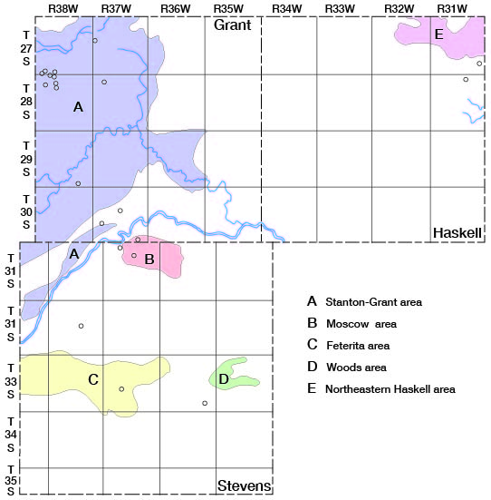
For the purpose of more detailed description, Grant, Haskell, and Stevens Counties may be divided into five areas based upon possibilities of further development of irrigation from wells: (1) Stanton-Grant area, (2) Moscow area, (3) Feterita area, (4) Woods area, and (5) northeastern Haskell area (Fig. 16).
Stanton-Grant area--The shallow-water area in western Grant, eastern Stanton, and northwestern Stevens Counties is one of the largest potential areas of irrigation in western Kansas (Fig. 16). The area in which the depth to water level is less than 100 feet is more than 500 square miles, of which about 280 square miles are in Grant County and 15 square miles are in Stevens County. (See Plate 2 of a report by Latta, 1941, and Plate 2 of this report.) Much of this land is not suitable for irrigation, but no attempt was made during this investigation to classify land according to its suitability for irrigation. Part of the land is underlain by dune sand, part is poorly drained, and part is unsuitable for other reasons. Nevertheless, there are many thousand acres of land in this area that could be irrigated with water from wells. The thickness of the saturated material is between 250 and 350 feet in most of the area but is only 200 feet in northwestern Grant County on the southeastern flank of the Syracuse anticline (Pl. 3).
It is not possible at present to estimate the quantity of water that could be pumped annually from wells in this area without depleting the supply of ground water. The water levels in all of the observation wells in this area fluctuate somewhat in accordance with precipitation, indicating that there is recharge from precipitation in this area. Theis, Burleigh, and Waite (1935, pp. 2, 3) believe that the average annual recharge from precipitation in the High Plains is about one-half inch of water. The recharge in the Stanton-Grant area probably exceeds the average recharge in the High Plains, inasmuch as the depth to water level probably is less than the average depth to water level in the High Plains. One-half inch of recharge annually would amount to more than 8.5 million gallons or 26.7 acre-feet for each square mile.
The heaviest pumping in this area is in northwestern Grant County, where there are several wells in a relatively small area. The pumpage of water in that area has not as yet caused appreciable lowering of the water table. In August 1944, the Division of Water Resources of the Kansas State Board of Agriculture installed an automatic water-level recorder on a well in the SE cor. NE 1/4 sec. 6, T. 28 S., R. 38 W., in the most heavily pumped area, so that a continuous record of the water level in this well will be available. If further development of irrigation in this area causes the water table to decline, steps can be taken to prevent overdevelopment. If the wells are properly spaced, several thousand acres could be irrigated without depleting the supply of ground water. Properly constructed wells in this area probably would yield 500 to 1,500 gallons of water a minute. In the valleys, where the water table generally is shallow, a battery of several wells connected to a centrifugal pump could be constructed. The yield of these wells generally is greater than the yield of single deep wells.
Moscow area--Additional land could be irrigated in the small area northwest of Moscow in northern Stevens and southern Grant Counties (Fig. 16). The land is relatively flat and the depth to water level is between 80 and 100 feet. The thickness of the saturated material ranges from about 150 feet in the eastern part of the area to about 280 feet in the northwestern part of the area. Test hole 33, in the NE cor. sec. 9, T. 31 S., R. 37 W., penetrated 280 feet of saturated material above the Dakota formation, and this test hole and the irrigation wells in this area encountered much coarse sand and gravel. The specific capacities of the irrigation wells in this area are relatively large. (Table 7, wells 244 and 247.)
Periodic measurements of water level have been made in one well (245) in this area, and were begun during the summer of 1942, which was a year of above-normal precipitation. Because of the below-normal precipitation in 1943 the water level declined, but because of above-normal precipitation in 1944 the water level reached its highest stage since, periodic measurements were begun. This indicates that the pumpage has had little or no effect on the water table and that there is recharge from precipitation. If there were excessive pumping in this, area and the water table declined, the Cimarron River in this area would become a losing stream instead of a gaining stream; and instead of ground water being lost by discharge into the river, the ground-water reservoir would be recharged by the downward movement of runoff water of the Cimarron River through the broad sandy stream channel.
Feterita area--The Feterita area extends from Hugoton through Feterita to Rolla in Morton County (Fig. 16). This area consists of all the land in which the depth to water level is less than 100 feet, except those areas covered by relatively young sand dunes which cause the land to be very sandy and irregular (Pl. 1). All this area is covered by mature and old-age sand dunes, but there are many parts of the area in which a good soil has developed and in which the land is relatively flat.
There is one irrigation well (299) in this area in Stevens County, but several have been drilled in the Morton County part of the area. The thickness of saturated material ranges from about 300 feet at the Morton-Stevens line to more than 400 feet in the eastern part of the area. There is little danger of overdevelopment of irrigation in this area because irrigation will necessarily be restricted to small areas where the soil and surface slopes are favorable.
This area is underlain by dune sand and the drainage is poorly developed; hence practically all the precipitation in this area moves downward toward the zone of saturation or evaporates, and little or no water is lost by runoff. Because the soil and topography of the area limit the development of irrigation, the recharge from precipitation in this area probably will be adequate to supply all the irrigation wells that may be constructed.
Woods area--The area of shallow water in the vicinity of Woods in eastern Stevens County is underlain by dune sand, much of which has an irregular surface slope and a very sandy soil (Fig. 16). The area most favorable for the development of irrigation is that in which the depth to water level is less than 100 feet and in which the dune sand has reached the mature or old-age stage of the dune-sand cycle (note pages 134, 135).
The depth to water level in this area ranges from about 75 feet to 100 feet and the thickness of saturated material is greater than in any other part of the Grant-Haskell-Stevens area. Test holes 38 and 39 encountered approximately 600 feet of saturated material above the Permian redbeds. This area is similar to the Feterita area in that irrigation can be developed only where the land is relatively flat and where the soil is not too sandy. This area and adjacent areas are underlain by dune sand containing many undrained basins. The recharge here is relatively large and probably would supply all the irrigation wells that will be constructed in the limited areas where both the soil and topography are suitable for the development of irrigation.
Northeastern Haskell area--The area of shallow water in northeastern Haskell County comprises about 25 square miles bounded on the north and west by sand dunes and on the south by the 100-foot isobath line (Fig. 16). The area extends into southeastern Finney County and west-central Gray County (Latta, 1944, pp. 122, 123). There are no irrigation wells in this area in Haskell County but there are two irrigation wells (134 and 145) south of the area where the depth to water exceeds 100 feet (Pl. 2). These wells penetrate thick deposits of sand and gravel and have relatively high specific capacities. There were six irrigation wells in the Gray County part of the shallow-water area in 1940. These wells are 110 to 165 feet deep and the depth to water level in them ranges from about 64 feet to about 110 feet. The yields of the wells range from about 800 to 1,100 gallons a minute (Latta, 1944, p. 122).
The depth to water in the Haskell County part of the area ranges from about 65 feet to 100 feet. The thickness of saturated material ranges from about 200 feet at the northeast corner of Haskell County to more than 300 feet in the southern and western parts of the area. Test hole 6 at the northeast corner of the area penetrated 207 feet of saturated material, of which 118 feet consisted primarily of sand or gravel or both (Pl. 3). A test hole (log 5) drilled at the NE corner sec. 31, T. 27 S., R. 30 W., Gray County, penetrated almost 300 feet of saturated material above the Dakota formation, nearly 200 feet of which was sand and gravel.
Inasmuch as the northeastern Haskell area is isolated and almost completely surrounded by large areas of sand dunes or areas in which the depth to water level exceeds 100 feet, it is believed that almost every suitable acre in the area could be irrigated with water from wells. Ground water moves into the area from the sand hills northwest of the area in southern Finney County. The large area of sand dunes serves as a catchment area for precipitation so that recharge of the ground-water reservoir probably greatly exceeds the average recharge in the High Plains. Because of this movement of water from the northwest and because very little irrigation can be developed in adjacent areas it is believed that many irrigation wells can be constructed in this area. A reasonable lowering of the water table in this area by pumping would increase the gradient of the water table and, therefore, would increase the movement of water from the sand-dune area.
Summary--The irrigation areas discussed in the preceding pages are limited to places in which the depth to water level is less than 100 feet, but, as stated above, there are six irrigation wells in Grant, Haskell, and Stevens Counties having a static water level of more than 100 feet. In addition, there are many irrigation wells in southwestern Kansas and the panhandle of Texas in which the static water level is more than 100 feet. Whether or not irrigation wells having a pumping lift of more than 100 feet can be operated economically is questionable. Because of the abundance of low-priced fuel in the Hugoton gas field the economic limit of pumping lift probably is as great or greater in this area than in any other part of the High Plains.
There are large areas in Grant, Haskell, and Stevens Counties where the depth to water level is slightly more than 100 feet and where irrigation could be developed if the cost of pumping is not too great. The Stanton-Grant area has been divided into two parts in Figure 15, the two parts being separated by an area in which the depth to water level ranges from 100 to 115 feet (Pl. 2). Similarly, in most of the area east of U.S. highway 270 between the Cimarron River and North Fork Cimarron River the depth to water level does not exceed 120 feet. Also there are many areas in Stevens County where the depth to water level is a little more than 100 feet and where the soil and topography are suitable for irrigation. Finally, the depth to water in most of that part of northeastern Haskell County lying between the 100-foot and 150-foot isobath lines is less than 110 feet (Pl. 2). The static water level in the areas mentioned above are more than 100 feet, but if a well penetrates an adequate thickness of coarse sand and gravel the drawdown will not be great and hence the pumping lift may be less than the lift in some wells having a static water level less than 100 feet. As irrigation with water from wells is increased in this area the economic limit of pumping lifts for various types of crops and for various climatic conditions probably will be determined.
Prev Page--Recovery || Next Page--Quality
Kansas Geological Survey, Geohydrology
Web version May 2002. Original publication date July 1946.
Comments to webadmin@kgs.ku.edu
The URL for this page is http://www.kgs.ku.edu/General/Geology/Grant/05_gw7.html