![]()
Prev Page--General Geology || Next Page--Water Table
Ground Water
Principles of Occurrence
The discussion of principles governing the occurrence of ground water that is given here takes account of conditions in Grant, Haskell, and Stevens Counties. Preparation of the discussion has been based chiefly on the authoritative and detailed treatment of the occurrence of ground water by Meinzer (1923), to which the reader is referred for more extended consideration. A general discussion of the principles of the occurrence of ground water with special reference to Kansas has been published by Moore (1940).
The rocks that make up the outer crust, of the earth generally are not entirely solid, but contain numerous openings, called voids or interstices, which may contain air, natural gas, oil, or water. The number, size, shape, and arrangement of the interstices in rocks depend upon the character of the rocks. The occurrence of water in any region, therefore, is determined by the geology.
The interstices or voids in rocks range in size from microscopic openings to the huge caverns found in some limestones. The open spaces generally are connected so that water may percolate from one to another, but in some rocks these open spaces are isolated and the water has little chance to percolate. In Grant, Haskell, and Stevens Counties the rocks from which ground water is obtained are poorly consolidated silt, sand, and gravel. Generally the sand and gravel of the Rexroad (?) and Meade formations contain many interstices and water percolates freely through them, but locally these interstices may be filled with calcium carbonate or other material, such as clay, that makes the rock almost impermeable. Some of the silt, sand, and gravel of the Rexroad and Meade formations is poorly sorted and the finer particles fill much of the space between the larger particles, thereby decreasing space available to ground water.
The porosity of a rock is the percentage of the volume of the rock that is occupied by the interstices. A rock is said to be saturated when all its interstices are filled with water or other liquid, and the porosity is then practically the percentage of the volume of rock that is occupied by water. The porosity of a rock determines only the amount of water a rock can hold, not the amount it may yield to wells. Some rocks may be moderately porous and yet will not yield an appreciable amount of water to a well. The permeability of a rock is defined as its capacity for transmitting water under pressure and is measured by the rate at which it will transmit water through a given cross section under a given difference of pressure per unit of distance. A rock containing very small interstices may be very porous but it would be difficult to force water through it, whereas a coarser-grained rock, although it may have less porosity, generally is much more permeable. Water may be held in rocks by the force of molecular attraction, which, in some fine-grained rocks, is sufficiently great to make the rock relatively impermeable.
Below a certain level in the earth's crust the permeable rocks generally are saturated with water and are said to be in the zone of saturation. The upper surface of the zone of saturation is called the ground-water table or simply the water table. All the rocks above the water table are in the zone of aeration, which ordinarily consists of three parts: the belt of soil water, the intermediate or vadose zone, and the capillary fringe.
The belt of soil water lies just below the land surface and contains a small amount of water held by molecular attraction. The soil zone must be saturated with water before any water can percolate downward to the water table. The thickness of the zone is dependent upon the character and thickness of the soil and upon the precipitation.
The intermediate or vadose zone lies between the belt of soil water and the capillary fringe. The interstices in the rocks in this zone generally are filled with air but may contain water for a short time while it is moving downward from the belt of soil water to the ground-water table. The vadose zone may be absent in places, such as some river valleys where the water table is near the surface, or it may be more than 200 feet thick, as in parts of Grant, Haskell, and Stevens Counties.
The capillary fringe lies directly above the water table and is formed by water rising from the zone of saturation by capillary action. The water in the capillary fringe is not available to wells, which must be deepened to the zone of saturation before water will enter them. The capillary fringe may be absent in coarse sediments, where the capillary attraction is negligible, but may be as much as 8 feet thick in very fine-grained sediments.
Water in Sand and Gravel
Grant, Haskell, and Stevens Counties are underlain by thick deposits of unconsolidated materials that were laid down by streams in Tertiary and Quaternary time. The sorting action of streams on these sediments caused the deposition of many distinct beds of gravel, sand, silt, and clay. Deposits of such uniform texture may have a relatively high porosity. Coarse, well-sorted gravel of this type has a relatively high specific yield and permeability, and properly constructed wells in this material yield large quantities of water. Some of the stream-laid material is poorly sorted and finer material occupies much of the pore space between the larger grains, reducing the porosity and specific yield.
In Grant, Haskell, and Stevens Counties, water is found in unconsolidated beds of sand and gravel in the Rexroad (?) and Meade formations and in the alluvium in the Cimarron River Valley. The Rexroad (?) and Meade formations are most important sources of ground water in the Grant-Haskell-Stevens area. Most of the domestic, stock, irrigation, industrial, and public-supply, wells in this area obtain water from these deposits. The yields of wells ending in the Rexroad (?) and Meade strata range from a few gallons a minute to more than 1,400 gallons a minute. The alluvium of the Cimarron River Valley probably would yield relatively large quantities of water to wells. The Cimarron River, however, has widened its channel and destroyed most of the bottom land, and as a result no irrigation has been developed in the valley area. The Laverne formation is an important potential source of ground water in this area but it is practically unexploited because of its great depth
Water in Sandstone
The particles comprising a sandstone generally are more even-grained and better sorted than those in unconsolidated sand and gravel. These particles are held together by cementing material which in some places may fill the interstices and prevent water from percolating through them. In this area, sandstone occurs in the Cheyenne and Dakota formations and locally in the Kiowa shale, but very few wells penetrate these beds because an adequate supply of potable water can be obtained in the overlying unconsolidated Tertiary and Quaternary deposits.
Water in Shale
Shale is formed by the induration of clay or clayey mixtures; it generally has a relatively low specific yield and therefore yields little or no water to wells. In some areas the shale may have many open joints and bedding planes and consequently a higher permeability; in other areas it may contain sand grains in sufficient quantity to make it somewhat permeable. In this area shale occurs in the Kiowa and Dakota formations and does not yield water to wells.
Permeability of Water-bearing Materials
The rate of movement of ground water is determined by the size, shape, quantity, and degree of interconnection of the interstices and by the hydraulic gradient. The capacity of a water-bearing material for transmitting water under hydraulic head is its permeability. The coefficient of permeability may be expressed as the rate of flow of water, in gallons a day, through a cross-sectional area of 1 square foot under hydraulic gradient of 100 percent at a temperature of 60 deg. F. (Meinzer's coefficient; see Stearns, 1927, p. 148.) The coefficient of transmissibility is a similar measure and may be defined as the number of gallons of water a day transmitted through each 1-foot strip extending the height of the aquifer under a unit-gradient (Theis, 1935, p. 520). The coefficient of transmissibility may also be expressed as the number of gallons of water a day transmitted through each section 1 mile wide extending the height of the aquifer, under a hydraulic gradient of 1 foot to the mile.
The coefficient of transmissibility is equivalent to the coefficient of permeability (corrected for temperature) multiplied by the thickness of the aquifer.
The coefficient of permeability of water-bearing materials can be determined in the laboratory (methods summarized by V.C. Fishel in Wenzel, 1942, pp. 56-58) or in the field. Pumping tests were made in Grant and Stevens Counties between June 1, 1941, and October 1, 1942, by Melvin S. Scanlan of the Division of Water Resources of the Kansas State Board of Agriculture and Woodrow W. Wilson of the Federal Geological Survey. Discharge measurements were made using a Collins flow meter (Pl. 8) and measurements of drawdown and recovery were made using a steel tape or an electrical measuring device, or both.
Theis (1935) has shown that to the extent that Darcy's law governs the motion of ground water under natural conditions and under the artificial conditions caused by pumping, an analogy exists between hydrologic conditions in an aquifer and thermal conditions in a similar thermal system. Darcy's law is analogous to the law of the flow of heat by conduction, hydraulic pressure being analogous to temperature hydraulic gradient to thermal gradient, permeability to thermal conductivity, and specific yield to specific heat. From his equation expressing the relation between the draw-down and the rate and duration of discharge of a well, Theis developed the following recovery formula for determining the transmissibility of an aquifer (as defined above):
T = (264q / s) log10(t / t1)
in which T = coefficient of transmissibility
q = pumping rate, in gallons a minute
t = time since pumping began, in minutes
t1 = time since pumping stopped, in minutes
s = residual drawdown at the pumped well, in feet at time t1
The residual drawdown (s) is computed by subtracting the static water-level measurement (Table 5) from water-level measurements made after pumping stops (Fig. 9). The proper ratio
log10(t / t1) / s
is determined graphically by plotting log10(t / t1) against corresponding values of s (Fig. 9). This procedure is simplified by plotting t / t1 on the logarithmic coordinate of semi-logarithmic paper. For any convenient value of log10(t/t1), the corresponding value of s may be found by inspection, provided the curve passes through the origin. If the curve does not pass through the origin, it can be made to do so approximately by applying an empirical correction to the 264 formula as follows:
T = (264q / s) log10[(t +/- c) / t1]
in which c is a correction factor (Wenzel, 1942, p. 127). Only one (well 115) of the curves for tests in Grant and Stevens Counties passed through the origin. The correction factors needed to make the other curves pass through the origin ranged from -185 to +147.
Figure 9--(A) Recovery curve for well 115. (B) Curve for pumping test on well 115 obtained by plotting s against t/t1.
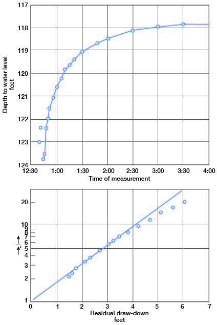
The weighted average discharge (q) of well 115 was 680 gallons a minute (Table 5). When values for s, (t / t1), and q are substituted in the Theis recovery formula, the coefficient of transmissibility of the water-bearing material at the pumped well is found to be 43,573. Dividing the coefficient of transmissibility by the average thickness of the saturated water-bearing material in the vicinity of the well, 295 feet, the average coefficient of permeability is found to be about 148. (The temperature of the water was 60 deg. F., hence no temperature correction is needed.) Data on seven pumping tests in Grant and Stevens Counties are listed in Table 6.
Table 5--Data on pumping test of well 115, Grant County, made on September 25, 1942, by Melvin Scanlan, Woodrow W. Wilson, and Thad G. McLaughlin.
| Time since | t / t1 | Yields (gallons a minute) |
Depth to water level (feet) |
Drawdown (feet) |
Remarks | |
|---|---|---|---|---|---|---|
| t, pumping started (minutes) |
t1, pumping stopped (minutes) |
|||||
| 116.36 | Static water level. Pump started |
|||||
| 6 | 652 | 139.59 | 23.23 | |||
| 36 | 557 | 139.47 | 23.11 | |||
| 66 | 536 | 140.1 | 23.74 | |||
| 96 | 768 | 140.06 | 23.7 | |||
| 126 | 746 | 140 | 23.64 | |||
| 156 | 756 | 139.65 | 23.29 | |||
| 186 | 750 | 139.59 | 23.23 | |||
| 194 | Pump stopped | |||||
| 195.5 | 1.5 | 130.3 | 123 | 6.64 | ||
| 197 | 3 | 65.67 | 122.35 | 5.99 | ||
| 200 | 6 | 33.33 | 123.76 | 7.4 | ||
| 202 | 8 | 25.25 | 123.5 | 7.14 | ||
| 204 | 10 | 20.4 | 122.4 | 6.04 | ||
| 206 | 12 | 17.17 | 121.96 | 5.6 | ||
| 208 | 14 | 14.86 | 121.51 | 5.15 | ||
| 212 | 18 | 11.78 | 121.04 | 4.68 | ||
| 216 | 22 | 9.82 | 120.59 | 4.23 | ||
| 221 | 27 | 8.19 | 120.2 | 3.84 | ||
| 226 | 32 | 7.06 | 119.85 | 3.49 | ||
| 231 | 37 | 6.24 | 119.63 | 3.27 | ||
| 236 | 42 | 5.62 | 119.43 | 3.07 | ||
| 246 | 52 | 4.73 | 119.1 | 2.74 | ||
| 263 | 69 | 3.81 | 118.7 | 2.34 | ||
| 276 | 82 | 3.37 | 118.51 | 2.15 | ||
| 306 | 112 | 2.73 | 118.15 | 1.79 | ||
| 336 | 142 | 2.37 | 118.01 | 1.65 | ||
| 366 | 172 | 2.13 | 117.87 | 1.51 | ||
The irrigation wells listed in Table 6 obtain water primarily from the Rexroad (?) formation but also from the lower part of the Meade formation. As indicated by the pumping tests, these deposits have low to moderate permeabilities, but because of the great thickness of saturated material the coefficient of transmissibility generally is large. Some wells, such as 299, penetrated deposits consisting primarily of silt, whereas wells 244 and 247 encountered thick deposits of sand and gravel. Two of the wells listed in Table 6 (30 and 56) penetrated the entire thickness of saturated material above the Cretaceous deposits.
Table 6--Results of pumping tests in Grant and Stevens Counties.
| Well No. | Water-bearing formations | Discharge (gallons a minute) | Drawdown (feet) | Duration of pumping (minutes) | Specific capacity (a) | Coefficient of transmissibility | Approximate thickness of water-bearing material (feet) | Coefficient of permeability (b) |
|---|---|---|---|---|---|---|---|---|
| 30 | Rexroad (?) and Meade | 1,122 | 23.03 | 199 | 48.7 | 53,954 | 247 | 218 |
| 56 | Rexroad (?) and Meade | 871 | 34.24 | 199 | 25.4 | 23,600 | 245 | 96 |
| 92 | Rexroad (?) and Meade | 456 | 22.8 | 183 | 20 | 4,485 | 350 | 13 |
| 115 | Rexroad (?) and/or Meade | 680 | 23.43 | 194 | 29 | 43,573 | 295 | 148 |
| 244 | Rexroad (?) and Meade | 1,086 | 12.54 | 218 | 86.6 | 147,028 | 295 | 498 |
| 247 | Rexroad (?) and Meade | 1,324 | 14.31 | 207 | 92.5 | 88,412 | 290 | 305 |
| 299 | Rexroad (?) and Meade | 551 | 82.8 | 319 | 6.7 | 3,853 | 480 | 8 |
(a) The specific capacity of a well is its rate of yield per unit of drawdown
and is determined by dividing the test capacity in gallons a minute by the
drawdown in feet.
(b) Coefficient of transmissibility divided by thickness of saturated
water-bearing material; temperature of water 60 deg. F., hence no
correction for temperature is needed.
Artesian Conditions
The head of water has been defined as the height that a column of water will rise in a tightly cased well which has no discharge. Ground water that rises in wells to a level above that at which the water is encountered is said to be artesian or "piestic" (Meinzer and Wenzel, 1942, p. 451).
The Rexroad (?) formation in places contains beds of saturated sand and gravel in which the ground water is confined by overlying beds of clay which are relatively impermeable. Wells drilled to these water-bearing beds encounter water under artesian head, and in Lakin Draw and North Fork Cimarron Valley the head is sufficient to cause a few of them to flow. Artesian water has been en-countered in many wells in Grant, Haskell, and Stevens Counties, but the water generally is not under sufficient head to flow at the surface.
The only flowing wells in this area are near Ulysses. Well 47 encountered artesian water at a depth of about 160 feet, and in 1943 it had a measured yield of 1.25 gallons a minute. A feebly flowing well about 2 miles southeast of Ulysses in North Fork Cimarron Valley was reported to be 220 feet deep.
Prev Page--General Geology || Next Page--Water Table
Kansas Geological Survey, Geohydrology
Web version May 2002. Original publication date July 1946.
Comments to webadmin@kgs.ku.edu
The URL for this page is http://www.kgs.ku.edu/General/Geology/Grant/05_gw.html