![]()
Prev Page--Introduction || Next Page--Stratigraphy
Geography
History
[History of the organization of these counties is taken primarily from Blackmar (1912).]
Grant County was created in 1887 by an act of the Kansas legislature by taking eight townships each from Hamilton and Kearny Counties. A census was taken in August 1887, indicating a population of 2,716. The county was organized in 1886 and the governor named Ulysses the temporary county seat. After the election of October 1888 Ulysses became the permanent county seat, having received more votes than the cities of Cincinnati and Surprise. The election was contested by Cincinnati but in 1890 the Supreme Court ruled in favor of Ulysses.
Because of the extended drought during the 1890s, which culminated in the panic of 1898, the population of Ulysses decreased from 1,500 to 40 and the bonded indebtedness grew to $84,000. In order to avoid financial chaos, the entire city (with the exception of the schoolhouse and courthouse) was moved 2 miles northwest and the city of New Ulysses was organized.
The unorganized county of Arapahoe was created by the legislature in 1873 and later (1883) became a part of Finney County. It was separated from Finney County in 1887 and named Haskell County for Dudley C. Haskell, congressman from Kansas. As a result of a census taken in March 1887 (population 2,841), the governor declared the county organized and named Santa Fe the temporary county seat. Santa Fe was chosen the permanent county seat by popular vote in preference to Ivanhoe and Lockport. In 1912, the Atchison, Topeka and Santa Fe Railway Company completed a branch line through Haskell County to Elkhart in Morton County. The city of Santa Fe was left without railroad facilities and the county seat was moved to Sublette.
The unorganized county of Stevens was created in 1873 and named for Thaddeus Stevens. The area became a part of Seward County in 1883 when the western boundary of Seward was extended to the Kansas-Colorado line. Stevens county was re-created in 1886, a census was taken (population 2,662), and Hugoton was designated the county seat.
Topography and Drainage
Grant, Haskell, and Stevens Counties are in the High Plains section of the Great Plains physiographic province. The area comprises parts of eight physiographic divisions (Fig. 2), most of which were defined by Smith (1940, pp. 140-146). These areas are described briefly in the following pages.
Figure 2--Map of Grant, Haskell, and Stevens counties showing physiographic divisions.
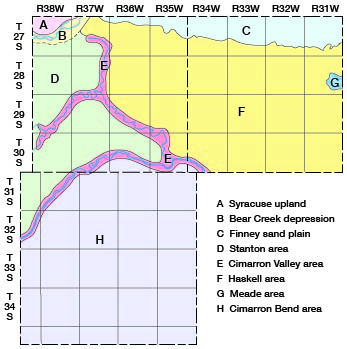
Syracuse upland--This is the name given by Smith to the long tableland that extends from western Hamilton County to northwestern Grant County. The area is relatively flat but has fairly steep slopes on all sides. It was formed primarily by the folding of the rock strata on the north and by faulting and subsidence of the strata on the south. The surface of the area slopes east-southeastward at the rate of 10 to 30 feet to the mile.
Bear Creek depression--Bear Creek crosses the northwestern corner of Grant County where it becomes a series of sinkholes and short intermittent streams rather than one continuous stream. It is bordered on the north and northwest by the Syracuse upland and on the east by the Haskell area. The southern boundary is not distinct, because it grades imperceptibly into the Stanton area.
Finney sand plain--The Finney sand plain (Smith, 1940) is an area intermediate in level between the Arkansas Valley and the uplands of the Haskell area. It extends from the Arkansas Valley southward into Grant and Haskell Counties (Fig. 2) and is covered by dune sand in all but its southern part. The southern boundary is a low bluff, which generally is less than 50 feet high.
Stanton area--Most of the western half of Grant County and the northwestern corner of Stevens County lie within the Stanton area, which is a broad, relatively flat plain that slopes east-northeastward. The lowest part of the area is near Bear Creek in the northwestern part of Grant County. The area is bordered on the south by the Cimarron River and on the east by Lakin Draw and North Fork Cimarron River.
Cimarron Valley area--The valleys of the Cimarron River, North Fork Cimarron River, Sand Arroyo, and Lakin Draw constitute the Cimarron Valley area (Pls. 5 and 6). These valleys have a relatively small amount of flat bottomland. In many places along the Cimarron Valley the bottomland has been cut away by the widening channel of the Cimarron River leaving only moderate pediment-like slopes along the sides of the valley. In other places, dune sand has been deposited within the valley and forms a typical sand-dune topography.
Haskell area--The Haskell area, which was named by Smith 1940), is a broad, relatively flat upland extending across most of Haskell County and the eastern half of Grant County. In contrast to the Stanton area, which slopes east-northeastward, the Haskell area slopes gently toward the east-southeast. The area is bordered on the east by Crooked Creek, on the north by the Finney sand plain, and on the south and west by the Cimarron River and its tributaries.
Meade area--The Meade area was defined by Smith (1940) as comprising the drainage basin of Crooked Creek. The headwaters of Crooked Creek are in easternmost Haskell County; therefore the Meade area comprises only a small part of the Grant-Haskell-Stevens area. The Meade area is lower than the Haskell upland and slopes toward the east.
Cimarron Bend area--The large upland area south of the Cimarron River was called the Cimarron Bend area by Smith (1940). It is a broad upland almost devoid of surface drainage and almost completely covered by sand dunes in various stages of development. The average slope is east-northeastward as in the Stanton area.
The Grant-Haskell-Stevens area is drained by the Cimarron River and its tributaries (North Fork Cimarron River, Crooked Creek, Bear Creek, and Lakin Draw). The Cimarron River rises in New Mexico and enters Stevens County northwest of Feterita. It flows northeastward through northwestern Stevens County, eastward through southern Grant County, and southeastward through the southwestern corner of Haskell County.
Bear Creek rises in southeastern Colorado and enters Kansas a few miles north of Saunders whence it flows northeastward and joins Little Bear Creek in northeastern Stanton County. From there the stream flows eastward and enters Grant County about 3.3 miles south of the northwest corner of the county. In Grant and Kearny Counties, Bear Creek is not a single stream but is a series of short intermittent streams whose courses are determined largely by depressions or sinkholes. The streams have no valley and have only small, shallow channels bordered by low natural levees. Many years ago flood waters flowed from one depression to another and terminated in the sand hills south of Lakin. Several dikes have been built in an attempt to control the flood waters of Bear Creek, and little water can now reach the sand hills in Kearny County. Much of the flood water spreads over the fields and some enters the Cimarron drainage system by way of Lakin Draw.
Crooked Creek rises in northeastern Haskell County (Fig. 21 and drains parts of Haskell, Gray, Ford, and Meade Counties. It enters the Cimarron River in northeastern Beaver County, Oklahoma.
North Fork Cimarron River flows across the northwestern corner of Stevens County and the southeastern corner of Stanton County and enters Grant County near its southwest corner. The stream flows northeastward to Ulysses where it turns abruptly toward the southeast and joins the Cimarron River near the southeast corner of the county.
Sand Arroyo flows across southern Stanton County and enters Grant County about 7 miles north of the southwest corner of the county. It enters North Fork Cimarron River a short distance cast of the Grant County line.
Lakin Draw is a short intermittent stream, which flows southward from northern Grant County to North Fork Cimarron River near Ulysses. Part of the flood waters of Bear Creek flow southward through Lakin Draw to North Fork Cimarron River, but because of the low gradient of Lakin Draw part of the flood waters of North Fork Cimarron River extend northward in the channel of Lakin Draw for about 2 miles above their confluence. [Mr. Joseph Jungferman, personal communication.]
Climate
The climate of Grant, Haskell, and Stevens Counties is much like that of other parts of the High Plains section, and is characterized by low precipitation, rapid evaporation, and a wide range of temperature. The summer days generally are hot but, due to the movement of wind and the low humidity, the nights are relatively cool. The winters are moderately cold, but. generally are free from excessive snowfall and damp cloudy days.
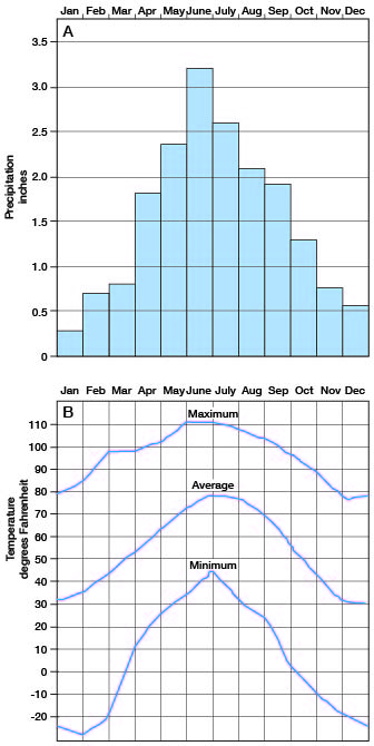
The mean annual precipitation in Grant, Haskell, and Stevens Counties is 17.71 inches. (All climatic data are from records of the U.S. Weather Bureau stations at Ulysses, Sublette, and Hugoton.) The precipitation in this area usually is sporadic and somewhat local, the amount of rainfall in one storm at times varying greatly from one part of the area to another. The highest annual precipitation on record in this area was 28.34 inches at Hugoton in 1941. The next to the highest annual precipitation was 27.36 inches at Ulysses, also in 1941. The highest annual precipitation at Sublette was 27.24 inches in 1923. The mean annual precipitation is 17.24 inches at Ulysses (Fig. 3), 18.02 inches at Sublette (Fig. 4), and 17.87 inches at Hugoton (Fig. 5). The greatest precipitation is during the summer, particularly in June, and the least is in December and January (Fig. 6). The mean annual temperature in this area is 54.6 deg. F. The temperature in this area has been as high as 111 deg. F. and as low as -28 deg. F.
Figure 3--Graph showing (A) annual precipitation at Ulysses, and (B) cumulative departure from normal precipitation at Ulysses.
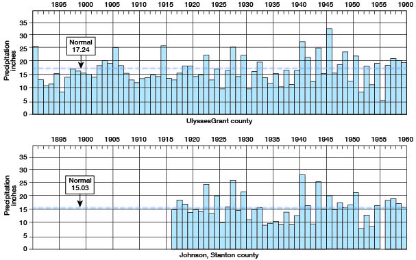
Figure 4--Graph showing (A) annual precipitation at Sublette, and (B) cumulative departure from normal precipitation at Sublette.
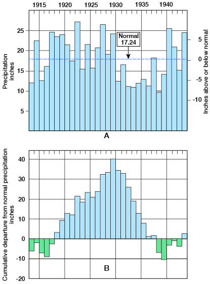
Figure 5--Graph showing (A) annual precipitation at Hugoton, and (B) cumulative departure from normal precipitation at Hugoton.
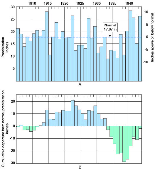
Figure 6--Graph showing (A) average monthly distribution of precipitation at Ulysses, Sublette, and Hugoton, and (B) monthly temperature ranges at Ulysses.
Mineral Resources
An important mineral resource of the Grant-Haskell-Stevens area is ground water, with which much of this report is concerned. Natural gas is another important mineral resource. A large part of the Hugoton gas field, the most important natural gas-producing area in Kansas, is located within these three counties. The first gas well in the Hugoton field was the Defenders Petroleum Company No. 1 Boles in sec. 3, T. 35 S., R. 34 W., in southwestern Seward County. It was completed in December 1922 and had an initial daily potential of 5 million cubic feet. The first gas well in the Grant-Haskell-Stevens area was the Independent Oil and Gas Company No. 1 Crawford, which was drilled in sec. 31, T. 33 S., R. 37 W., in May 1927 to a depth of 3,502 feet. In January 1928, it was plugged back to the gas-producing zone at. 2,620 feet and had an initial daily potential of 8 million cubic feet. There was little drilling in the field until 1930 and 1931 after the Argus Pipe Line Company had completed a pipe line from the gas field to Dodge City. There was additional drilling in 1936 and 1937 after the Northern Natural Gas Company and the Panhandle Eastern Pipe Line Company had completed pipe lines that connected the field with their major lines at Mullinville and Arkalon.
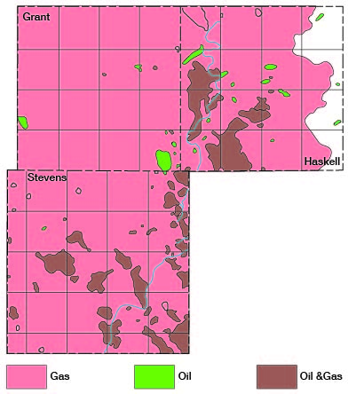
Drilling activities in the Hugoton area are described in the annual oil and gas development, reports published by the State Geological Survey. Bulletin 54 (Ver Wiebe, 1944) and Bulletin 56 (Ver Wiebe, 1945) contain large maps that show all wells drilled in this field to the end of 1943 and 1944, respectively. On January 1, 1945, there were 328 gas wells in the Grant-Haskell-Stevens area, including 70 wells in Grant County, 41 in Haskell County, and 217 in Stevens County (Fig. 7). These wells had an average deliverability of 1,788,623 cubic feet of gas a day. [Deliverability standard pressure is 311.6 pounds per square inch. Data supplied by R.J. Phillippi of the Kansas State Corporation Commission.] The aggregate potential open flow of 265 of these wells was more than 3 billion cubic feet of gas a day in 1943. In 1944 the entire Hugoton field produced 83,007,568,000 cubic feet of gas and by the end of that year the total production from the field was more than 433 billion cubic feet.
Figure 7--Oil and gas fields of Grant, Haskell, and Stevens counties. Current information on oil and gas production can be found on online.
According to Hemsell (1939, pp. 1054-1067), gas occurs in at least two zones and as many as six zones in the Permian rocks in the Hugoton field. The first gas is encountered about 10 feet below the top of the Herington limestone member of the Nolans limestone, which is the uppermost formation in the Wolfcampian series. Much larger quantities of gas are obtained from the Krider limestone member, which is at the base of the Nolans limestone. Additional quantities of gas are obtained from the Winfield limestone, from two zones in the Fort Riley limestone member of the Barneston limestone, and in a few places from the Florence limestone member of the Barneston limestone. Hemsell states that the gas-bearing beds dip 12 to 14 feet a mile east-southeastward toward the Anadarko Basin. Along the west side of the Hugoton field these beds grade laterally into red and brown elastics which serve as a trap for the gas that is migrating up the monoclinal structure.
By estimating that the average porosity of the gas-producing beds is 12 percent and that their average thickness is 45 feet, Hemsell computed that the Hugoton gas field originally had a reserve of 7.4 million cubic feet of gas to the acre. The proved area in Kansas, therefore, had a total reserve of nearly 12 trillion cubic feet of gas (Hemsell, 1939, p. 1061).
Deposits of volcanic ash occur in several places in Grant County (Pl. 12) and at one place in Haskell County, but only one deposit has been worked commercially (Landes, 1928, pp. 22, 23, 26-28). This deposit (owned by Western Spar Products Company) is in the NW 1/4 sec. 24, T. 30 S., R. 35 W., and formerly was connected to the Atchison, Topeka and Santa Fe railroad by a narrow gauge spur line. According to Landes (1928), the ash has an average thickness of 9 feet and is of good quality, ranking third among the 37 samples analyzed by him. The screen analysis of the ash from Grant County is given in Table 1. Several thousand tons of ash have been taken from this deposit and it has been estimated that 15,000 tons of ash remain.
Table 1--Screen analysis of volcanic ash from NW 1/4 sec. 24, T. 30 S., R. 35 W., Grant County (Landes, 1928, p. 23). Percent by Weight.
| More than 0.833 mm |
0.833-0.147 mm | 0.147-0.074 mm | 0.074-0.046 mm | Less than 0.046 mm |
|---|---|---|---|---|
| 0.2 | 5 | 18 | 25 | 52 |
Another deposit of volcanic ash, in NE 1/4 sec. 24, T. 30 S., R. 35 W., is reported to belong to the Pumicite Company and to contain about 60,000 tons of ash. Volcanic ash also is found in the following places in the Grant-Haskell-Stevens area: (1) NW 1/4 sec. 17, T. 30 S., R. 35 W., owned by C.D. Hickok estate, Ulysses, Kansas; (2) SW 1/4 sec. 6, T. 30 S., R. 35 W., owned by Charles P. Metcalf, Lawrence, Kansas; (3) SW, sec. 7, T. 29 S., R. 37 W., owned by Dan Sullivan, Ulysses, Kansas; (4) SE 1/4 sec. 19, T. 30 S., R. 34 W., owned by F.E. Murphy, Sublette, Kansas.
Sand and gravel is another mineral resource of this area, and is used primarily for road metal. It is found mainly along the Cimarron River and North Fork Cimarron River in the lower part of the Meade formation of Pleistocene age.
Agriculture
The soils of Grant, Haskell, and Stevens Counties are derived primarily from loess and dune sand. A relatively thin deposit of loess covers most of the Haskell and Stanton areas and the northern part of the Cimarron Bend area. The soils derived from loess are dark compact clay-barns and silty clay-barns, which are especially suited for growing wheat and other small grains. Dune sand covers most of the Finney sand plain and most of the Cimarron Bend area (Pl. 1). Soils derived from dune sand are very sandy and are susceptible to wind erosion. Where the sand dunes are relatively old, however, the soils are developed more fully and are less susceptible to wind erosion. The older dune-sand soils are especially suited for growing row crops.
A total of 918,632 acres of land was under cultivation in Grant, Haskell, and Stevens Counties in 1940. (All agricultural data, unless otherwise stated, are from records of the U.S. Census Bureau). There were 1,128 farms in the three counties and the average farm comprised 842 acres. The following list of crops grown in Grant, Haskell, and Stevens Counties was compiled by the 1940 census (Table 2).
Table 2--Acreage of principle crops grown in Grant, Haskell, and Stevens Counties.
| Crop | 1929 | 1939 |
|---|---|---|
| Wheat | 478,194 | 158,005 |
| Sorghums | 76,495 | 62,416 |
| Corn | 62,597 | 359 |
| Broomcorn | 14,799 | 4,716 |
| Root and grain crops (other than annual legumes) |
[No record available] | 3,454 |
| Mixed grains | [No record available] | 2,722 |
| Barley | 9,019 | 1,036 |
| Hay (exclusive of sorghums) | 703 | 728 |
As indicated by Table 2, the total acreage of crops grown in the three counties decreased greatly between 1929 and 1939. This was caused primarily by abnormally low precipitation during that period. The precipitation since 1940 has been above normal and the total acreage of crops has increased greatly.
Population
The population of Grant, Haskell, and Stevens Counties has fluctuated nearly in accordance with climatic conditions. The population probably was greatest during the land boom between 1885 and 1890, although no official census was taken at that time. Many towns were organized at that time, including 11 towns in Grant County and at least five in Haskell and Stevens Counties.
The population of the counties is shown in Table 3. (All population data, unless otherwise stated, are from records of the U. S. Census Bureau.)
Table 3--Population of Grant, Haskell, and Stevens Counties from 1889 to 1939.
| 1889 | 1899 | 1909 | 1919 | 1929 | 1939 | |
|---|---|---|---|---|---|---|
| Grant County | 1,308 | 422 | 1,087 | 1,087 | 3,092 | 1,946 |
| Haskell County | 1,077 | 457 | 993 | 1,455 | 2,805 | 2,088 |
| Stevens County | 1,418 | 620 | 2,453 | 3,943 | 4,655 | 3,193 |
| Total | 3,803 | 1,499 | 4,533 | 6,485 | 10,552 | 7,227 |
There are five cities in Grant, Haskell, and Stevens Counties. They are Ulysses, county seat of Grant County (population 824); Sublette, county seat of Haskell County (population 582); Satanta, (population 345) also in Haskell County; Hugoton, county seat of Stevens County (population 1,349); and Moscow (population 177), also in Stevens County.
Transportation
Branch lines of the Atchison, Topeka and Santa Fe Railway Company cross Grant, Haskell, and Stevens Counties and serve the principal communities. All state and federal highways in the three counties are hard surfaced. U.S. highway 160 enters Grant County from the west and extends east through Ulysses and Hickok to the site of the old town of Santa Fe in Haskell County and thence south into Seward County. U.S. highway 270 enters Grant County from the west and serves the communities of Ulysses, Hugoton, and Woods. U.S. highway 83 crosses the middle of Haskell County from north to south. Kansas highway 25 crosses Grant County from north to south and terminates at Hugoton. Kansas highway 45 parallels the Atchison, Topeka and Santa Fe railroad through Haskell and Stevens Counties and Kansas highway 51 crosses Stevens County as a part of U.S. Highway 270 and Kansas highway 45.
In addition to the highways, there are many graveled county and township roads in the area. Most of the roads are not surfaced, but because of slight precipitation and rapid evaporation the earth roads are passable during most of the year.
Prev Page--Introduction || Next Page--Stratigraphy
Kansas Geological Survey, Geohydrology
Web version May 2002. Original publication date July 1946.
Comments to webadmin@kgs.ku.edu
The URL for this page is http://www.kgs.ku.edu/General/Geology/Grant/03_geog.html