![]()
Prev Page--Table of Contents || Next Page--Geography
Introduction
Purpose and Scope of the Investigation
An investigation of the geology and ground-water resources of Grant, Haskell, and Stevens Counties was begun in May 1941, by the United States Geological Survey and the State Geological Survey of Kansas, with the cooperation of the Division of Sanitation of the Kansas State Board of Health and the Division of Water Resources of the Kansas State Board of Agriculture. The work was done under the general administration of R.C. Moore, state geologist, J.C. Frye, acting state geologist, and O.E. Meinzer, geologist in charge of the Division of Ground Water of the Federal Geological Survey, and under the direct supervision of S.W. Lohman, federal geologist in charge of ground-water investigations in Kansas.
Ground water is one of the principal natural resources of Kansas. This is particularly true in western Kansas where surface-water supplies are limited. The entire population of Grant, Haskell, and Stevens Counties obtains its water supply from wells. In addition, wells supply water for livestock and for the irrigation of more than 2,000 acres of land. Ground water acquires its great value as a natural resource because relatively large supplies are in storage and available for use at any time, and these supplies are replenished continuously or at intervals by precipitation, stream flow, or both. If withdrawals of ground water are kept within safe limits, the supply should last indefinitely.
The investigation in Grant, Haskell, and Stevens Counties was made to determine the quality, quantity, movement, and availability of ground water and the feasibility of further development of irrigation from wells. It is hoped that the data given herein will facilitate the safe development of the ground-water resources of these counties.
Location and Extent of the Area
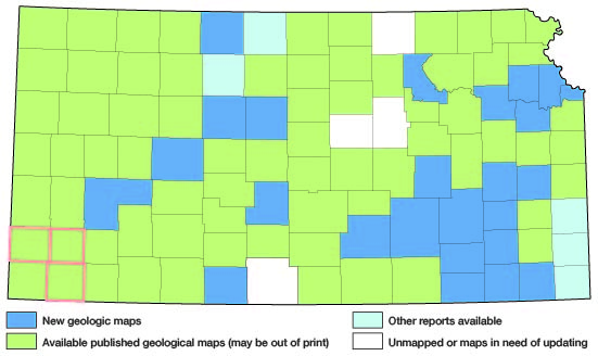
Grant, Haskell, and Stevens Counties are in southwestern Kansas (Fig. 1). They are bordered on the west by Stanton and Morton Counties, on the north by Kearny and Finney Counties, on the east and southeast by Gray, Meade, and Seward Counties, and on the south by Texas County, Oklahoma. The area lies between parallels 37 deg. and 37 deg. 45' north latitude and meridians 100 deg. 39' and 101 deg. 34' west longitude. It comprises about 52 townships and has an area of 1,881 square miles.
Figure 1--Index map of Kansas showing area described in this report and areas covered by other geologic maps, as of Feb. 2002. For additional information, please visit the KGS Geologic Maps of Kansas Page.
Previous Investigations
Geologic and hydrologic studies in southwestern Kansas were made in 1885 by Hay (1890) who briefly discussed the geology and depths to water in this area. A similar but less detailed study was made in the same area in 1886 by St. John (1887). A more detailed study with particular reference to ground water in the Dakota and younger formations was made in 1895 and 1896 by Haworth (1897; l897a). Johnson (1901; 1902), in his reports on the utilization of the southern High Plains, made special reference to the source, availability, and use of ground water in western Kansas. Parker (1911) described briefly the ground-water conditions in Grant, Haskell, and Stevens Counties in his report on the chemical character of the water supplies of Kansas. Haworth (1913) made additional studies of ground-water conditions in this area in 1913.
The first detailed study of the geology and ground-water resources of this area was made by Darton (1920) in his description of the Syracuse and Lakin quadrangles, which include the northern part of Grant County. His report includes maps showing geology, topography, and depths to water level. More recently this area was described briefly by Theis, Burleigh, and Waite (1935) who made a reconnaissance of the ground-water resources of the High Plains; and by Smith (1940) who made a reconnaissance of the Tertiary and Quaternary geology of southwestern Kansas. Schoff (1939) made a detailed geologic and hydrologic study of Texas County, Oklahoma, which borders Stevens County on the south.
Since 1938 the State and Federal Geological Surveys in cooperation with the Division of Sanitation of the Kansas State Board of Health and the Division of Water Resources of the Kansas State Board of Agriculture have made detailed studies of the geology and ground-water resources of most of the counties in southwestern Kansas (Fig. 1). These include Stanton County (Latta, 1941), Morton County (McLaughlin, 1942), Ford County (Waite, 1942), Meade County (Frye, 1942), Hamilton and Kearny Counties (McLaughlin, 1943), Finney and Gray Counties (Latta, 1944), Seward County (Byrne and McLaughlin, in press), and Scott County (Waite, in press.)
Methods of Investigation
An observation-well program was begun in Grant and Haskell Counties by Woodrow W. Wilson in May and June 1941. About 30 representative wells were selected for periodic water-level measurements. Most of these wells have been measured monthly since that time in order to obtain information concerning the fluctuations of the ground-water table.
Field work in Grant and Haskell Counties was begun by the writer in July 1941 and continued through October 1941. In October 1941, an observation-well program was begun in Stevens County by Woodrow W. Wilson and the writer. Field work in Stevens County was done during July, August, and September 1942, and additional work was done in Grant and Haskell Counties in October 1942. Several days were spent in field investigations in this area in 1943 and 1944 by Claude W. Hibbard and the writer.
Data were obtained on 356 wells in Grant, Haskell, and Stevens Counties during this investigation. About 277 wells were measured with a steel tape to determine the depth of the well and the depth to the water level below some fixed measuring point (generally the top of the casing). Additional data concerning the yield and drawdown of irrigation wells were obtained by measurement or from well owners. Only reported data were obtained for those wells that could not be measured, including the depth of the well, the depth to water level, the yield and drawdown of the well, and the character of the water-bearing materials. Seventy-two samples of water were collected from representative wells and were analyzed by Howard A. Stoltenberg, chemist, in the Water and Sewage Laboratory of the Kansas State Board of Health.
Thirty-nine test holes were drilled at strategic points in the area by the portable hydraulic-rotary drilling machine (Pl. 4) of the State and Federal Surveys, operated by Ellis D. Gordon, James B. Cooper, and Oscar S. Fent. The locations of these holes are shown on Plate 3. Test holes 1, 2, 3, 4, 5, 23, 35, and 38 were drilled in connection with investigations of the geology and ground-water resources of adjacent counties.
The drill cuttings were collected and studied in the field and later were examined microscopically in the office. The altitudes of the measuring points of the measured wells and of the test-hole locations were determined with a plane table and alidade. Those in Grant and Haskell Counties were determined by a level party headed by John B. LaDuex and those in Stevens County were determined in part by a level party headed by Richard N. Tripp and in part by a level party headed by Charles K. Bayne.
The field data were recorded on maps prepared for the Kansas Highway Planning Board by the Kansas Highway Department (Pls. 1 and 2). The roads and drainage on these maps were corrected by field observations and from aerial photographs obtained from the United States Department of Agriculture.
Wells shown on Plate 2 were located within the sections by use of the odometer, and the locations are believed to be accurate to 0.1 mile. The wells in each county are numbered by townships from north to south and by ranges from east to west, and within a township the wells are numbered in the same order as the sections. The Grant County wells are numbered from 1 to 129, the Haskell County wells from 130 to 227, and the Stevens County wells from 228 to 356. For each well shown on Plate 2 the number above the line corresponds to the number of the well in the well tables and the number below the line is the depth to the ground-water table below the land surface.
Acknowledgments
Residents of the three counties were very cooperative in permitting the measurement of their wells and in supplying information about their wells and about the rock formations penetrated by the wells. In addition they permitted test drilling on their land and allowed pumping tests to be made on their wells. Data on the municipal water supplies were furnished by the city water departments. R.J. Phillippi of the Kansas State Corporation Commission supplied much information about the Hugoton gas field. Claude W. Hibbard spent several days in the field with the writer and made available much information about the stratigraphy and paleontology of the Tertiary and Quaternary deposits in Meade County and adjacent areas.
The manuscript for this report has been reviewed critically by S.W. Lohman, O.E. Meinzer, and W.D. Collins, of the Federal Geological Survey; J.C. Frye, acting state geologist; Paul D. Haney, director, and Ogden S. Jones, geologist, of the Division of Sanitation of the Kansas State Board of Health; and George S. Knapp, chief engineer of the Division of Water Resources of the Kansas State Board of Agriculture. Plates 1 and 2 and all figures were prepared under the supervision of Eileen Martin of the State Geological Survey. Plate 3 was prepared by Robert White.
Prev Page--Table of Contents || Next Page--Geography
Kansas Geological Survey, Geohydrology
Web version May 2002. Original publication date July 1946.
Comments to webadmin@kgs.ku.edu
The URL for this page is http://www.kgs.ku.edu/General/Geology/Grant/02_intro.html