![]()
Prev Page--Water Table || Next Page--Recovery
Ground Water, continued
Ground-water Recharge
Recharge is the addition of water to the underground reservoir and may be accomplished in several ways. All ground water within a practical drilling depth beneath Grant, Haskell, and Stevens Counties is derived from water that falls as rain or snow either within the area or within nearby areas to the west and north. Once the water becomes a part of the ground-water body it moves down the slope of the water table, later to be discharged at some point farther downstream.
The underground reservoir beneath this area is recharged primarily by local precipitation. Other important factors affecting recharge in this area are seepage from streams and depressions and subsurface inflow from areas to the west and north.
Recharge from Precipitation
The average annual precipitation in Grant, Haskell, and Stevens Counties is about 18 inches, but probably only a small part of this water reaches the zone of saturation owing to several factors. Of the precipitation in this area, part is lost by evaporation and transpiration, part is lost by runoff, and the remainder may percolate downward to the zone of saturation.
The quantity of water lost by evaporation depends on several factors, including temperature, humidity, vegetative covering, depth to water level below land surface, and the length of time the processes of evaporation have access to the moisture. The topography of Grant, Haskell, and Stevens Counties is characterized by flat uplands containing numerous sinks and depressions and by large areas of dune sand having little or no surface drainage. Much of the moisture that falls in this area is held in the sinks, depressions, and other undrained areas until it evaporates or moves downward to the zone of saturation. Large lakes caused by heavy precipitation in the Bear Creek depression (Pl. 6) may exist for many months before being dried by evaporation and seepage. A large part of the precipitation in Grant, Haskell, and Stevens Counties probably is lost by evaporation, but also some of the precipitation is lost by transpiration from plants, particularly from May through August when precipitation is highest and plant growth is most abundant.
Because the drainage in this area is poorly developed, only a small percentage of the precipitation is carried away by the Cimarron River and its tributaries; hence the loss by runoff is relatively small. Most of the floods in the Cimarron River are caused by heavy precipitation in New Mexico, Colorado, and Oklahoma and local precipitation seems to have comparatively little effect on the stream flow.
Water that is not lost by evaporation, transpiration, and runoff percolates downward into the soil zone. The soil will absorb moisture until the amount of water it contains is greater than can be held against the pull of gravity, at which time part of the water moves downward to the zone of saturation. This downward movement may be prevented by plant transpiration which, during the growing season, may deplete the soil moisture as rapidly as it can be replenished by the precipitation. At the end of the growing season the moisture in the soil may be depleted. Water that enters the soil zone during the fall and winter tends to replenish the soil moisture because there is less transpiration and evaporation during these seasons. From this time until transpiration and evaporation again become important factors, much of the precipitation moves downward through the soil and to the water table. Because of the high rate of transpiration and evaporation, there probably is little recharge during the summer except where the water table is relatively near the land surface.
Hydrographs showing the fluctuations of water levels in 21 wells in Grant, Haskell, and Stevens Counties are shown in Figures 13, 14, and 15 together with the precipitation at the nearest station of the U.S. Weather Bureau. These graphs show a relatively close correlation between the water levels in wells and the precipitation. The correlation is particularly close in areas where the depths to water level are not great, but the influence of precipitation upon water levels is noticeable even in areas of great depth to water level.
Figure 13--Hydrographs showing fluctuations of the water levels in seven wells in Grant County, cumulative departure from normal monthly precipitation at Ulysses, and monthly precipitation at Ulysses.
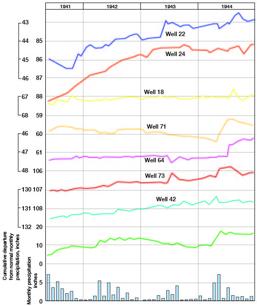
Figure 14--Hydrographs showing fluctuations of the water levels in seven wells in Haskell County, cumulative departure from normal monthly precipitation at Sublette, and monthly precipitation at Sublette.
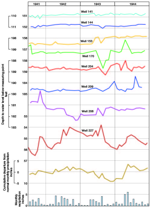
Figure 15--Hydrographs showing fluctuations of the water levels in seven wells in Stevens County, cumulative departure from normal monthly precipitation at Hugoton, and monthly precipitation at Hugoton.
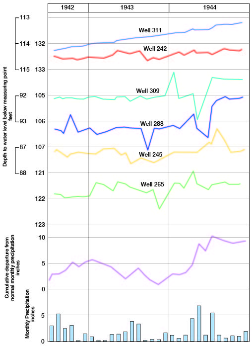
Water levels in wells 22 and 24 in Grant County are approximately 3 feet higher than they were when periodic water-level measurements were begun in 1941 (Fig. 13); hence the recharge of the ground-water reservoir in the vicinity of these wells has been relatively large. Water levels in other wells, such as 73, 42, 141, 144, 153, 242, and 311 (Figs. 13, 14, 15), in which the depth to water level is more than 100 feet, have risen much more slowly but just as steadily and with smaller fluctuations. The water levels in wells 18, 64, 71, 73, 245, and 288 remained approximately the same or rose slowly from 1941 until 1944 when they rose abruptly, even though the precipitation was not as great in 1944 as it was in 1941. In 1941 the soil moisture had been nearly depleted after 10 years of drought and most of the precipitation that seeped below band surface was used to replenish the soil moisture; therefore, very little water moved downward to the zone of saturation. In 1944, however, there was adequate soil moisture and much of the rainfall percolated downward to the zone of saturation, causing an abrupt rise in water levels.
The trend of the water level in well 227 correlates closely with the cumulative departure from normal monthly precipitation. The well is in the Cimarron Valley near the Satanta bridge where the Cimarron is a losing stream. At least part of the sharp peaks on the hydrograph show the effect of flood waters in the nearby channel.
The water levels in 67 percent of the observation wells in these counties were higher at the end of 1943 than they were at the beginning of record, probably as a result of the above-normal precipitation during 1941 and 1942. Owing to the below-normal precipitation in 1943 the water levels in several wells declined, but because of heavy precipitation during the first half of 1944 the levels again rose. At the end of 1944, the water levels in 92 percent of the observation wells were higher than at the beginning of record.
Only fragmentary records of the water levels in wells in Grant, Haskell, and Stevens Counties for the years preceding 1941 are available; hence the effect of the drought between 1931 and 1940 on the water table is not known. The first water-level measurements in the Grant-Haskell-Stevens area were made in Haskell County in 1891 by members of the Nettleton survey (Nettleton, 1892). During the present investigation an attempt was made to locate and measure some of the old wells that were measured in 1891, but the last one had been destroyed during the preceding year. Several wells were found near the sites of the old wells, however, and measurements of water level in these wells indicate that the depths to water level in the deep-water areas in Haskell County were approximately the same in 1891 as they were in 1942. The static water level in an old dug well in the NE 1/4 sec. 25, T. 29 S., R. 33 W. was 200 feet in 1891. The static water level in a well in the same quarter section, but probably a few hundred feet south, was 201.7 in 1942. The land surface in that vicinity is nearly level; therefore the difference in altitude of the measuring points of the two wells probably did not exceed 2 or 3 feet.
Recharge from precipitation in the Finney sand plain in northern Grant and Haskell Counties and in the dune-sand area south of the Cimarron River probably is relatively rapid. The many undrained basins in these areas serve as catchment areas for the rainfall, and the porous sandy soil permits the downward percolation of water to the zone of saturation. Most of the precipitation in these areas percolates downward or evaporates.
There probably is much recharge in the Cimarron Bend area, even though the depth to water level in most places is more than 100 feet and in many places is more than 200 feet. The water-table contour maps of Morton (McLaughlin, 1942, Pl. 1), Stevens (Pl. 1), and Seward (Byrne and McLaughlin, 1946, Pl. 1) Counties show that in general the ground water is moving east-southeastward from the Cimarron River, which forms the northwestern boundary of the area. The water table along most of the Cimarron Valley in this area is either lower or higher than it is in adjacent upland areas. Ground water adjacent to the Cimarron Valley moves toward the river but does not cross the depression or ridge on the water table. For this reason, little or no ground water can move into the Cimarron Bend area from adjacent areas north and west of the river; therefore most of the ground water in this area is derived from local precipitation.
Recharge from precipitation in the upland areas which are not covered by dune sand probably is much less than in the Finney sand plain and the Cimarron Bend area. These uplands, such as the Stanton and Haskell areas, contain numerous undrained basins but the soil is less porous and the depth to water level generally is great; hence only a small part of the precipitation reaches the ground-water reservoir. In the northern part of the Stanton area and in the Bear Creek depression the recharge probably is relatively large because there are numerous sinkholes and depressions and because the depth to water level in most places is less than 50 feet.
Recharge from precipitation in the valleys probably is very large. The sandy soil is very porous and the water table is near the land surface; hence water can readily percolate downward to the zone of saturation. In addition, some of the runoff from adjacent uplands may percolate downward in the valley areas to recharge the ground-water reservoir.
Recharge from Seepage
Some water is contributed to the ground-water reservoir by seepage from streams. Bear Creek, Lakin Draw, and Sand Arroyo are losing streams; that is, the stream channels are above the water table and water moves downward to recharge the ground-water reservoir. The Cimarron and North Fork Cimarron Rivers are losing streams along parts of their courses, and in such places some of the flood water moves downward to the zone of saturation. The Cimarron River is a losing stream in northwestern Stevens, eastern Grant, and southwestern Haskell Counties, whereas in western Grant County it is a gaining stream (Fig. 11). Water that is discharged into the river in western Grant County generally evaporates or percolates downward before it reaches the Grant-Haskell line.
Recharge by Subsurface Inflow
Ground water in Grant, Haskell, and Stevens Counties is derived in part by subsurface inflow from Stanton and Morton Counties on the west and from Kearny and Finney Counties on the north. This movement of water into the area is indicated by the slope of the water table (Pl. 1) and by the quantity of fluoride in the water (Fig. 17). Along the fault at the southern and eastern edges of the Syracuse anticline, the Dakota formation is level with the Tertiary and Quaternary silt, sand, and gravel, and the high-fluoride water from the Dakota formation moves southeastward into the Tertiary and Quaternary deposits of Grant County.
Discharge of Subsurface Water
The discharge of subsurface water has been divided by Meinzer (1923a, pp. 48-56) into vadose-water discharge (discharge of soil water not derived from the zone of saturation) and ground-water discharge (discharge of water from the zone of saturation).
Vadose-water Discharge
The discharge of soil water not derived from the zone of saturation is called vadose-water discharge and includes the discharge of water directly from the soil by evaporation and through growing plants by transpiration. The consumption of soil water by crops is large and is of vital importance to agriculture. This consumption of soil water generally reduces the recharge, for the deficiency of soil moisture must be replenished before recharge can take place.
Ground-water Discharge
Ground-water discharge is the discharge of water directly from the zone of saturation or from the capillary fringe and may take place through evaporation and transpiration or as hydraulic discharge through springs, seeps, wells, or infiltration galleries.
Discharge by transpiration and evaporation--Water may be taken into the roots of plants directly from the zone of saturation or from the capillary fringe, and be discharged from the plants by the process known as transpiration. The depth from which plants will lift the ground water varies with species of plants and types of soil. The limit of lift by ordinary grasses and field crops is not more than a few feet; however, alfalfa and certain types of desert plants have been known to send their roots to depths of 60 feet or more to reach the water table (Meinzer, 1923, p. 82).
Discharge of ground water by evaporation and transpiration in Grant, Haskell, and Stevens Counties probably is limited to areas where the depth to water level is small, such as the Cimarron Valley area, Bear Creek depression, and parts of the Stanton area. In these areas such discharge probably is very slight except in the lowlands along the Cimarron River and North Fork Cimarron River. In North Fork Cimarron Valley some ground water is transpired by alfalfa, and much water is evaporated from the small ponds in the stream channel that are fed by ground-water discharge. Water is also discharged by evaporation from the broad sandy channel of the Cimarron River, particularly in parts of Stevens and Grant Counties where the water table is at or near the level of the channel. The discharge by transpiration along the Cimarron River probably is not great because of the scanty vegetative covering.
Discharge by springs and seeps--Some ground water in this area is discharged by springs and seeps, although the amount is relatively small. Most important of these is Wagon Bed Spring, in the north half of sec. 33, T. 30 S., R. 37 W. near the Ulysses bridge, at a well-known camp site on the old Santa Fe trail. There are a few other springs and many seeps along the Cimarron River and North Fork Cimarron River but they are small.
Discharge by wells--Another method of discharge of water from the ground-water reservoir is by pumping from wells. There were 20 irrigation wells in operation in this area in 1943 and there were municipal wells at Ulysses, Sublette, Satanta, Moscow, and Hugoton. Most of the rural residents of the area derive their domestic and stock supplies of water from wells, but the amount of water discharged for this purpose is relatively small. The recovery of ground water from wells is discussed in the next section.
Prev Page--Water Table || Next Page--Recovery
Kansas Geological Survey, Geohydrology
Web version May 2002. Original publication date July 1946.
Comments to webadmin@kgs.ku.edu
The URL for this page is http://www.kgs.ku.edu/General/Geology/Grant/05_gw4.html