![]()
Prev Page--Quaternary-Pleistocene || Next Page--Ground-water Resources 1
Structural Geology
A detailed treatment of the structural geology is beyond the scope of this report. Certain aspects of the structural geology, however, both regional and local, are readily discernible in the outcropping and near-surface rocks and are summarized in the following paragraphs.
Regional Structure
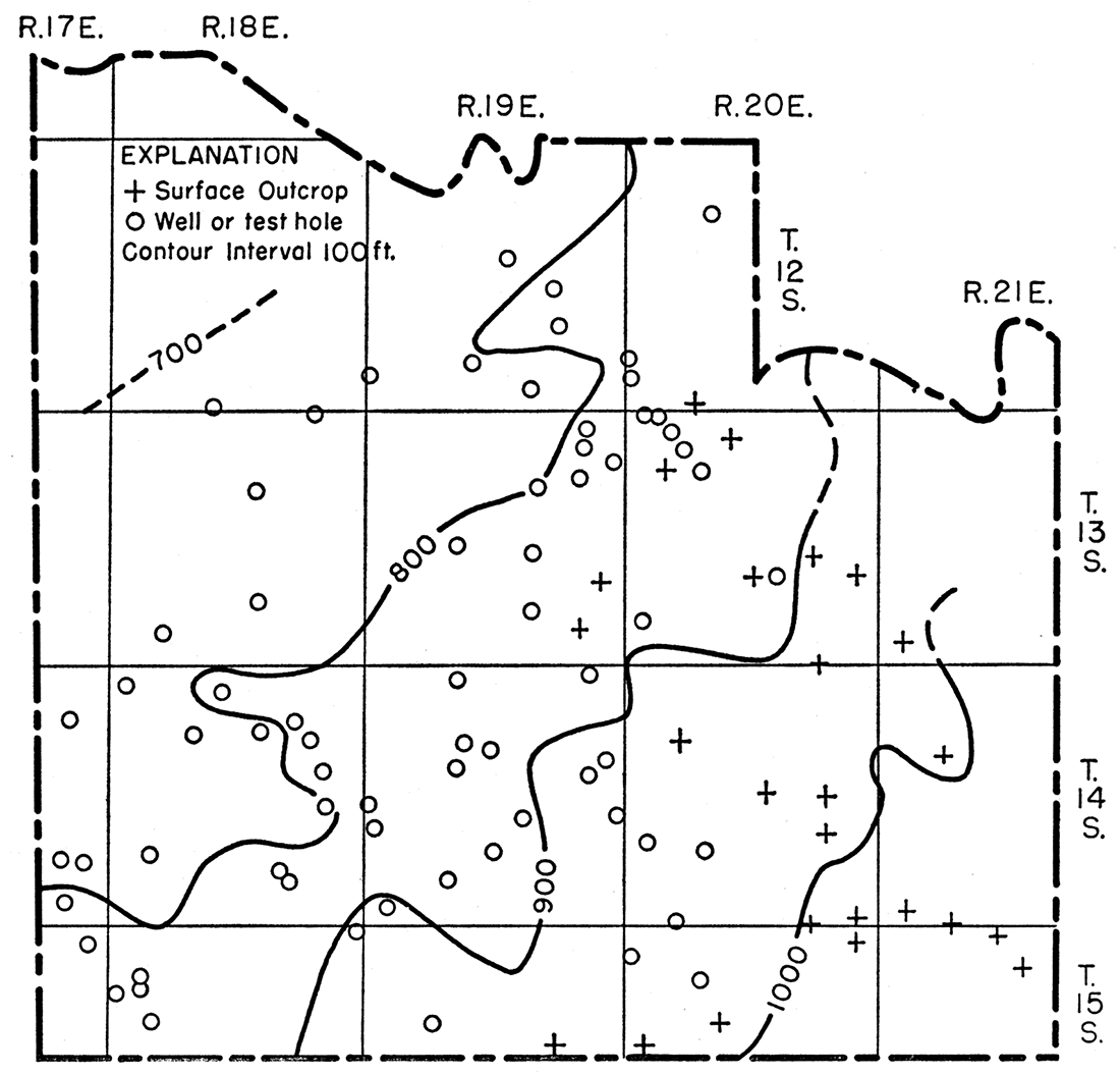
The Prairie Plains Monocline is the dominant regional structure that affects Pennsylvanian rocks, which dip westward and northwestward about 20 feet per mile in eastern Kansas and parts of the neighboring states (Prosser and Beede, 1904). This structure is chiefly post-Permian in age. A structural map of Douglas County on which the top of the Haskell Limestone member of the Stranger Formation is used as a datum (Fig. 7) indicates a general dip to the northwest of slightly less than 20 feet per mile. The gentle northwest dip of the Pennsylvanian rocks is evident also on the geologic map (Pl. 1). Superimposed on the regional structure are many smaller synclinal and anticlinal structures. The amount of structural deformation shown generally increases appreciably with depth from the surface rocks into the older Pennsylvanian and Mississippian rocks. Thus a low anticline or structural nose in the surface rocks mav reflect greater structural relief in the deeper Pennsylvanian rocks and at the top of the Mississippian.
Figure 7.--Structure contours on top of Haskell Limestone member of Stranger Formation.
Faulting and Folding
In southern Douglas County several faults and sharp structures have been observed in the Douglas Group and the Oread Limestone. Rich (1932a) first described these features as follows: South of a curved line marked by sharp flexing and faulting, which for several miles of its course closely follows the northern arc of a circle of about a 4-mile radius, the Toronto Limestone is missing; the Leavenworth Limestone is thicker than average and the Heebner Shale is abnormally thick, 16 feet instead of 6. The Plattsmouth Limestone at several places along the arc was faulted so that south of the fault it lies at the same level as the Toronto Limestone north of the break. These relations indicate (a) uplift of the area south of the curved line so that the Toronto either was not deposited or was eroded after deposition; (b) a renewal of movement, causing a relative sinking of the area south of the fault line while the Leavenworth Limestone and Heebner Shale were deposited; (c) deposition of Plattsmouth Limestone over all the area; and finally, (d) post-Plattsmouth faulting with downthrow to the south.
Patterson (1933) while studying the Douglas Group in the Baldwin area also made observations regarding the problem as follows: The Toronto Limestone has been removed by post-Toronto pre-Snyderville erosion in the Baldwin area and for at least 10 miles to the southwest of Baldwin. Post-Toronto pre-Snyderville erosion was deepest near Baldwin (SW cor. sec. 35, T. 14 S., R. 20 E.) where the upper 80 feet of the Lawrence Shale was eroded in addition to the Toronto Limestone. At the locality cited a limestone conglomerate overlain by 35 feet of Snyderville Shale rests on sandstone beds of the Ireland Sandstone. As mentioned by Rich (1932a) the Snyderville Shale, Leavenworth Limestone, and Heebner Shale are abnormally thick. Beds of Snyderville age deposited above the unconformity are predominantly shale near Baldwin, but to the southwest sand was deposited locally.
Laughlin (1957), who mapped adjacent areas of Franklin County to the south in T. 15 and 16 S., R. 17-19 E., indicated several areas in which the Toronto Limestone member is missing, but showed adjacent areas on each side in which the Toronto is present. Although faults are not indicated on the boundaries of these areas, except in one area northwest of Centropolis, a critical examination of the contacts might indicate post-Toronto pre-Leavenworth faulting and erosion of the Toronto member from these areas. Laughlin (personal communication also noted an area (SW cor. sec. 29, T. 15 S., R. 18 E.) in which the Leavenworth Limestone member is missing but the overlying Plattsmouth and underlying Toronto limestones are present.
O'Connor and others (1955) noted three small faults in the Oread Limestone and slightly younger formations in Osage County and suggested the possibility of faults in other localities. Core drilling by the Corps of Engineers at the Pomona dam site in eastern Osage County in 1956 (sec. 17, 19, and 20, T. 16 S., R. 17 E.) revealed the presence of multiple low-angle faults in the lower Oread Limestone and the upper Lawrence Shale. The Toronto Limestone is absent in some of the cores and present in others.
Post-Stranger pre-Lawrence Faulting
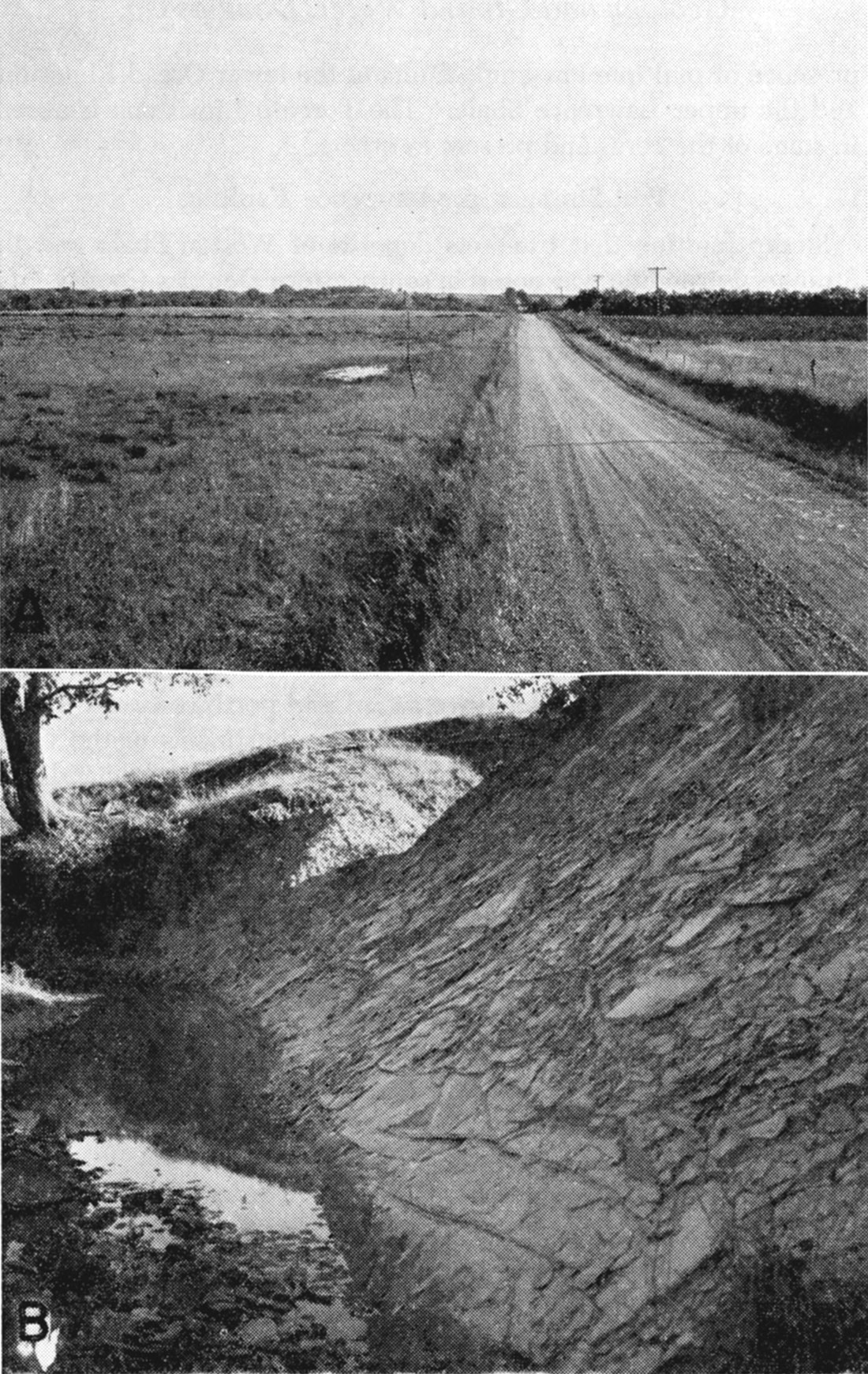
Slump faulting that transects deposits of Weston Shale and the Stranger Formation was noted in southeastern Douglas County (sec. 33, T. 14 S., R. 21 E.). There, post-Stranger pre-Lawrence erosion cut through the Stranger Formation and deeply into the underlying Weston Shale creating a relatively steep walled valley about half a mile wide. Slump faulting caused large blocks of the valley wall to slide into the valley. This may or may not have been associated with small tectonic stresses in deeper rocks. The upper part of one such block, rotated so that the beds dip 35' to the east, may be observed (Pl. 9B) along the west bank of a creek near the center of sec. 33, T. 14 S., R. 21 E. Farther south along this creek near the south line of the section and adjacent parts of the NW NW sec. 4, T. 15 S., R. 21 E., the Haskell Limestone and Vinland Shale members have westward and northwestward dips of 5° to 12° perhaps representing secondary adjustments of the valley wall after slump faulting of the large blocks. The Ireland Sandstone member was then deposited in the post-Stranger pre-Lawrence erosional valley, filling it with conglomerate, sandstone, and shale. Essentially undisturbed beds of the Ireland overlie and abut the steeply dipping beds of the Weston and Stranger in these exposures. Minor slump structures resulting in dips of 5° to 12°, associated with post-Stranger pre-Lawrence erosion were noted also at several other outcrops in southeastern Douglas County.
Worden Fault
The principal fault affecting the surface rocks in southern Douglas County is of post-Toronto pre-Leavenworth age. From the vicinity of Baldwin a fault trends west in the lower tier of sections in T. 14 S., to a point just west of Worden, where it curves southward along the boundary between R. 18 and 19 E. to the Franklin County line. Mapping by Laughlin (1957) in northwestern Franklin County indicates that this fault may continue several miles farther south and west. The name Worden fault is proposed for this feature as the line of the fault is near the community of Worden. Although discussed and mapped as a single fault, it may be a series of en echelon faults of approximately the same age. The Worden fault marks the northern boundary of an area in southern Douglas County in which the Toronto Limestone member of the Oread Limestone either was not deposited or was removed after deposition.
The next limestone above the Toronto, the Leavenworth Limestone member, is present both north and south of the Worden fault. The presence of the Leavenworth throughout the area dates the earliest movement on the Worden fault as post-Toronto pre-Leavenworth. At the cast edge of Baldwin, in an outlier of Oread Limestone (Pl. 1), the basal part of that unit is represented by a conglomerate of reworked Toronto Limestone, which is further evidence of very late Toronto or Snyderville structural adjustments and modified sedimentation patterns. In the Baldwin vicinity the Worden fault may pass into a sharp flexure. An indication of the amount of post-Toronto pre-Snyderville uplift or erosion in the area is observable in the Baldwin area (NW sec. 35, T. 14 S., R. 20 E.). Here the interval between the basal conglomerate of the Oread Limestone and the top of the Haskell Limestone is 60 to 65 feet, whereas in adjacent areas to the north the interval is the normal 140 to 170 feet. This suggests probable erosion of about 100 feet of Lawrence Shale in this area.
The evidence for the Worden fault throughout most of its mapped extent consists of the abrupt termination of the Toronto Limestone member. A clearly discernible fault surface in the underlying Lawrence Shale is nowhere well exposed in Douglas County, although shear zones in these beds have been observed in adjacent Franklin and Osage Counties. Locally sinkholes have developed in the Plattsmouth Limestone along this and associated faults (Pl. 9A).
Plate 9—A, Nearly circular small water-filled sinkhole developed in Plattsmouth Limestone member of the Oread Limestone along Worden fault in the SE NW sec. 33, T. 14 S., R. 19 E., Plattsmouth member underlies surface in foreground and aiso hill 40 feet higher in background; B, Shale beds dipping 35° E. in post-Stranger pre-Ireland fault block adjacent to channel containing Ireland Sandstone member of Lawrence Shale. Normal dip of beds in this area is less than 1/2° NW. Tilted shale beds overlain by undisturbed beds of Ireland member. View south from NE cor. SW sec. 33, T. 14 S., R. 21 E.
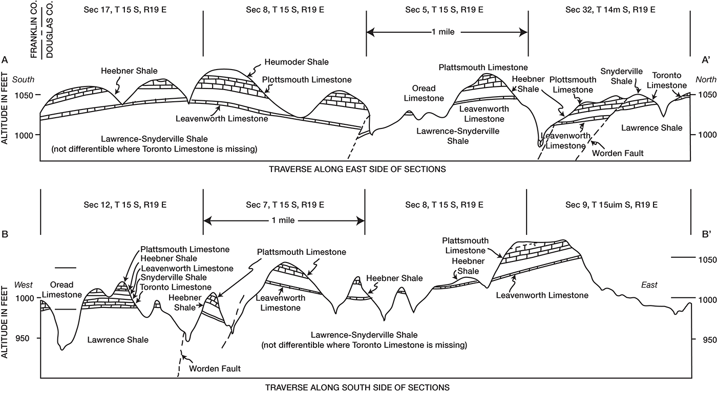
As Rich indicated, there are several places along and near the Worden fault where the Plattsmouth Limestone member is faulted down to the south approximately to the position of the Toronto Limestone member north of the fault (Fig. 8A). There are also exposures of faulted Leavenworth Limestone member showing 5 to 10 feet of vertical displacement. Tilted beds of Lawrence Shale having dips of as much as 22° NE along the Worden fault-flexure zone are exposed in road cuts for a quarter of a mile cast of the center of sec. 2, T. 15 S., R. 20 E.
Figure 8.--Geologic sections in vicinity of Worden fault, southern Douglas County.
Summary
Faulting and sharp flexing occur in rocks of the Douglas and Pedee Groups and the Oread Limestone in southern Douglas County and adjacent areas to the south and west. Reconnaissance structural mapping on the underlying Stanton Limestone indicates that the faults and sharp flexures shown in the rocks of the Douglas and Oread do not similarly affect the Stanton Limestone. Detailed structural mapping will be necessary to determine whether faults and flexures in the rocks of the Douglas and Oread are reflected locally in the deeper rocks also. The faulting and sharp flexures affecting the beds of the Douglas, Pedee, and Oread are judged, on the basis of data now available, to be chiefly nontectonic, and an explanation for the structural features must be found in the post-Stanton rocks.
The post-Stranger pre-Ireland topography observed in southeastern Douglas County indicates that there was as much as 100 feet of local relief and at least one deep channel approximately half a mile wide incised to within 30 feet of the Stanton Limestone locally. Evidence of slumping associated with the cutting and filling of one post-Stranger pre-Ireland channel has previously been cited, and sliding likely occurred at other places west and south along this channel also. The erosional valley was subsequently filled with the Ireland Sandstone, which formed a narrow wedge at the base and broadened irregularly upward to a thickness of 100 to 150 feet locally. Adjacent to this wedgelike sandstone body, the rocks above the Stanton Limestone were principally shale.
Irregularities in thickness and distribution of the sandstone and shale in the Lawrence Shale and the resulting differences in amount of compaction also resulted in flexures in the overlying Oread Limestone. The Worden fault, one of the most prominent and conspicuous of the postdepositional adjustments along the margins of the thick Ireland Sandstone member, resulted in the nondeposition or erosion of the Toronto Limestone member over parts of the area. Other beds of the Oread Limestone show thickness changes and less extensive faulting because of subsequent continuing adjustments in and adjacent to the area of thick Ireland Sandstone.
Although much new information regarding the structure and stratigraphy, beyond that described by Rich (1932a) and Patterson (1933), is known regarding this part of southern Douglas County, northwestern Franklin County, and eastern Osage County, many features are still poorly understood. Detailed surface and subsurface stratigraphic studies and structural mapping in the three counties will be necessary before the history of this area is clearly understood.
Prev Page--Quaternary-Pleistocene || Next Page--Ground-water Resources 1
Kansas Geological Survey, Geohydrology of Douglas County
Web version Aug. 1999. Original publication date Dec. 1960.
Comments to webadmin@kgs.ku.edu
The URL for this page is http://www.kgs.ku.edu/General/Geology/Douglas/struct01.html