![]()
Prev Page--Subsurface Stratigraphy || Next Page--Douglas and Shawnee Groups
Stratigraphy of Outcropping Rocks
Pennsylvanian System--Missourian Series
Lansing Group
Plattsburg Limestone
The Plattsburg Limestone is the lowermost and oldest outcropping formation in Douglas County. It is poorly exposed in the bluff along Kansas River east of Eudora, and along the lower part of Captain Creek and parts of Little Wakarusa Creek. The formation comprises the following three members in ascending order: Merriam Limestone, Hickory Creek Shale, and Spring Hill Limestone. In the subsurface the formation ranges in thickness from about 12 to 32 feet.
Spring Hill Limestone member--Only the Spring Hill Limestone member of the Plattsburg Limestone is exposed in Douglas County. It is light-gray to light-tan thin-bedded, wavy-bedded argillaceous limestone, and is about 13 to 22 feet thick in the Eudora area. Composita, echinoid, and crinoid fragments are common.
Vilas Shale
The Vilas Shale is poorly exposed east of Eudora along Kansas River and Captain Creek and locally south of Eudora along Little Wakarusa Creek. It is chiefly gray or greenish-gray silty shale in the upper part and sandy micaceous shale or silty sandstone in the middle and lower parts. Locally the lower middle part may be dark from disseminated carbonaceous material. The shale ranges from about 10 to 26 feet in thickness in the Eudora area, but may be much thinner in the subsurface. Except for carbonaceous plant fragments and sparse mollusks, the formation is not fossiliferous.
Stanton Limestone
The Stanton Limestone comprises three limestone and two shale members and is a resistant cuesta-forming formation. It commonly has a thickness of about 44 feet and is well exposed along stream bluffs in the vicinity of Eudora.
Captain Creek Limestone member--The Captain Creek Limestone member, which was named for exposures east of Eudora along Captain Creek, is the lowermost member of the Stanton Limestone. The Captain Creek is gray or gray blue, dense, and fine grained, and when weathered its even, massive bedding is noticeable. In the middle or upper part a persistent zone of Enteletes pugnoides is observed and is characteristic. Fusulinids and small Cryptozoon are common in the upper part also. The Captain Creek has a thickness of 6 to 7 feet.
Eudora Shale member--Shale beds about 7 feet thick compose the Eudora Shale member. The middle lower part is typically a black, carbonaceous fissile and thin-bedded shale. Commonly about half a foot of gray or buff shale separates the dark shale from the top of the Captain Creek Limestone member. The upper part of the member consists of gray or greenish-gray thin-bedded shale. Except for conodonts and macerated plant fragments in the black fissile beds, the shale is not fossiliferous.
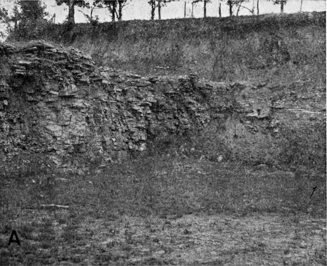
Stoner Limestone member--The Stoner Limestone member is the thickest and most persistent bench-forming member of the Stanton. It has a thickness of 15 to 17 feet in outcrops, and quarries in the Eudora vicinity (Pl. 4A). It is light-bluish-gray, wavy-bedded limestone containing numerous thin shaly partings. The limestone is fine grained and contains much crystalline calcite. Although not so fossiliferous as cyclical equivalents in the Shawnee Group, such as the Plattsmouth and Beil Limestones, it contains numerous brachiopods, crinoid and echinoid fragments, bryozoans, and fusulinids. The upper surface of the member is hummocky and irregular.
Plate 4—A, Stoner Limestone member of Stanton Limestone overlain by Kansan glaciofluvial deposits in quarry, NE cor. sec. 4, T. 13 S., R. 21 E.
Rock Lake Shale member--Outcrops of the Rock Lake Shale member are chiefly marine sandstone in this area. The member commonly has a thickness of 10 to 15 feet, but locally is as thin as 4 feet. Where the member is thick the lower part consists of gray, blue, and green shale containing carbonized plants and, locally, a thin coal less than I inch thick. The middle and upper parts consist of gray, buff, or dark-brown thin-bedded to massive very fine grained micaceous sandstone. Marine fossils, chiefly the pelecypods Myalina and Aviculopecten, in the upper part serve to distinguish this sandstone from the younger non-marine Tonganoxie Sandstone. Where the member is thin it comprises roughly equal parts of shale and sandstone, The contact of the marine sandstone with the underlying shale is distinct and uneven and suggests a disconformity. A complete section of the Rock Lake Shale is well exposed and has a thickness of about 15 feet in the Killough quarry in the NW sec. 20, T. 13 S., R. 21 E. Here the overlying South Bend Limestone rests on massive sandstone of the Rock Lake Shale, and ground water has locally dissolved parts of the limestone and reprecipitated it in the upper sandstone beds. This has resulted in. the development of a gradational contact between these members and a hard calcite-cemented sandstone in the upper part of the Rock Lake Shale member.
South Bend Limestone member--The uppermost member of the Stanton Limestone, the South Bend Limestone, has a thickness of about 1 to 4 feet. It is medium-bedded, blocky, fine-grained to sandy gray limestone. Although the upper contact is distinct, the lower contact may be gradational into sandstone of the underlying Rock Lake Shale member. The member is fossiliferous, containing abundant fusulinids and several species of brachiopods. Locally it is disconformably overlain by basal deposits of the Stranger Formation, or is absent, and the Stranger Formation rests on the Rock Lake Shale member.
Pedee Group
Weston Shale
The Weston Shale conformably overlies the Stanton Limestone and is overlain disconformably by the Stranger Formation and the Lawrence Shale. Locally the Weston Shale is absent where post-Weston erosion cut deep channels through the shale into the Stanton Limestone, and the younger rocks of the Douglas Group directly overlie the Stanton Limestone. The shale is thickest where the Stranger Formation is thin, and is best exposed in the Vinland and Clearfield areas.
The Weston Shale consists of slightly more than 100 feet of gray-blue and gray marine shale. The lower 50 to 60 feet is a hard medium-gray or bluish laminated and fissile clayey shale containing several zones of dense pinkish-gray clayey-ironstone concretions, which weather yellowish brown or reddish brown. The concretions are elliptical, flattened parallel to the bedding, and 2 to 12 inches in diameter occurring both in layers and as scattered concretions. The upper part of the formation is commonly more bluish than the lower part, is a slightly silty clayey shale, and at least locally has carbonized plant fragments at the bedding planes. The upper part also contains clay-ironstone concretions, but they are generally smaller and less numerous than those in the lower part.
Marine fossils in the formation are sparse, but thin fossiliferous zones contain fragments of bryozoans, crinoids, and brachiopods. Weathered outcrops of the shale are mottled olive and gray, or tan, the color depending on the degree of oxidation of the beds.
Some exposures of the Weston Shale directly underlying the unconformity show evidence of a soil development, as represented by a more massive blocky claystone indicative of the B horizon of a soil enriched with clay, and lacking the fissile shaly texture typical of Weston Shale. A caliche zone is present also in some places.
Prev Page--Subsurface Stratigraphy || Next Page--Douglas and Shawnee Groups
Kansas Geological Survey, Geohydrology of Douglas County
Web version Aug. 1999. Original publication date Dec. 1960.
Comments to webadmin@kgs.ku.edu
The URL for this page is http://www.kgs.ku.edu/General/Geology/Douglas/strat02.html