![]()
Prev Page--Table of Contents || Next Page--Geography
Introduction
Purpose and scope of investigation
A study of the geology and ground-water resources of Douglas County was begun in the spring of 1952 by the State Geological Survey of Kansas and the U. S. Geological Survey in cooperation with the Division of Sanitation of the Kansas State Board of Health and the Division of Water Resources of the Kansas State Board of Agriculture. As water from wells constitutes an important supply for municipal, industrial, irrigation, domestic, and stock needs, this investigation was made to determine the distribution, thickness, and lithologic and hydrologic properties of the rocks containing fresh water in the county.
Because rocks older than late Missourian (Pennsylvanian) age do not contain fresh water they are considered only briefly in this report. Other mineral resources and the structural geology of the area also are discussed briefly. Data regarding present and potential ground-water developments, together with the effects of pumping on discharge, recharge, and quality of the water, are summarized for the principal aquifers.
Location and extent of area
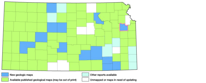
Douglas County is in central eastern Kansas and is bounded on the north by Jefferson and Leavenworth Counties, on the east by Johnson County, on the south by Franklin County, and on the west by Osage and Shawnee Counties (Fig. 1). It includes all or parts of 22 townships, constituting about 474 square miles.
Figure 1.--Index map of Kansas showing area described in this report and areas covered by other geologic maps, as of Jan 1998. For additional information, the KGS Geologic Maps of Kansas Page.
Previous investigations
The sequence of rocks that crop out in Douglas and adjacent eastern Kansas counties has been studied and described by many geologists (Haworth, 1894, 1894a, 1895; Bennett, 1896; Beede, 1898; Todd, 1909, 1911, 1918, 1918a; Hinds and Greene, 1915; Wing, 1921; Schoewe, 1923, 1924, 1930, 1930a, 1930b, 1949; Moore, 1932, 1936, 1949; Rich, 1932, 1932a, 1933; Patterson, 1933; Moore, Elias, and Newell, 1934; Newell, 1935; Hoover, 1936; Moore and Landes, 1937; Moore, Frye, and Jewett, 1944; Frye and Walters, 1950; Lins, 1950; Moore and others, 1951; Frye and Leonard, 1952; O'Connor and others, 1955; Ball, 1957; Laughlin, 1957; and Sanders, 1957). Coal resources of the area have been studied by Haworth (1898), Whitla (1940), Bowsher and Jewett (1943), and Abernathy, Jewett, and Schoewe (1947).
Studies relating to the ground water resources have been made by Bailey (1902), Haworth (1913), Moore and others (1940), Lohman (1941), Davis and Carlson (1952), Merriam (1954), Foley, Smrha, and Metzler (1955), Grimes (1957), and Dufford (1958).
The subsurface geology has been described by McClellan (1930), Ockerman (1935), Lee (1943), Lee and others (1946), Lee, Leatherock, and Botinelly (1948), and Lee and Merriam (1954). The geology pertaining to oil and gas has been discussed by Jewett and Abernathy (1945) and by Jewett (1949, 1954). Named structures that have geographic application to Douglas County have been listed by Jewett (1951). Recently Farquhar (1957) has summarized information on the geology of the Precambrian rocks in Kansas.
Methods of investigation
The data upon which this report is based were obtained chiefly in the spring and summer of 1952 and 1953 during which time wells were inventoried, test holes were drilled, water samples were collected for chemical analysis, and most of the areal geology was mapped. About three months of additional field work between 1954 and March 1957 included the drilling of several more test holes, inventorying additional wells, collecting additional water samples for chemical analysis, conducting pumping tests, logging water wells, and completing the geologic mapping. Data submitted to March 1957 by cooperating water-well drillers are included in the report.
Geologic and ground-water data collected and given in reports by Lohman (1941), Davis and Carlson (1952), and Dufford (1958) were partly restudied, and some were modified before inclusion in this report. Test holes reported in Table 9 were drilled with a hydraulic-rotary drilling machine owned by the State Geological Survey and operated by W. T. Connor, K. L. Walters, and E. L. Reavis, and with a power auger operated by John Perry and William Gellinger. Drill cuttings were collected in the field and later examined microscopically in the laboratory. Altitudes of wells and test holes were determined by W. W. Wilson and the author by planetable and alidade surveys or by interpolation from 7.5-minute topographic maps having 10-foot contour intervals.
The base map used in Plates I and 2 was compiled from aerial photographs obtained from the Production and Marketing Administration, U. S. Department of Agriculture, and from maps of the Soil Conservation Service, the State Highway Commission of Kansas, and the Kansas Turnpike Authority. Areal geology was mapped on aerial photographs (scale 1:20,000) and later transferred to a 1:40,000-scale base map.
Well-numbering system
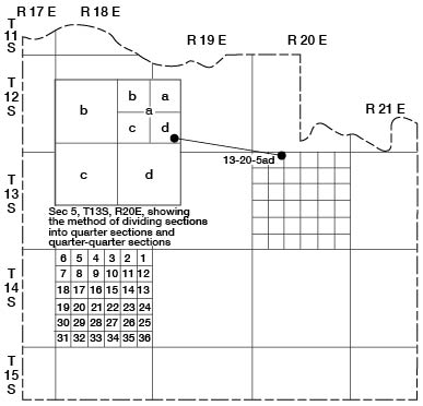
The well and test-hole numbers used in this report give the location of wells according to General Land Office surveys. The well number is composed of township, range, and section numbers, followed by lower case letters that indicate the subdivision of the section in which the well is located. The first letter denotes the quarter section, the second letter denotes the quarter-quarter section, or 40-acre tract, and the third letter, when used, indicates the quarter-quarter-quarter section, or 10-acre tract. The 160-acre, 40-acre, and 10-acre tracts are designated a, b, c, or d in a counterclockwise direction, beginning in the northeast quarter. When two or more wells are located within a 10-acre tract, the wells are numbered serially according to the order in which they were inventoried. An example of the well-numbering system is given in Figure 2.
Figure 2--Map of Douglas County illustrating the well-numbering system used in this report.
Acknowledgments
Appreciation is expressed to the many residents who supplied information concerning local geology, wells, and water supplies. Mr. N. J. Burris, of the State Board of Health, and water superintendents of the towns in the area provided information on municipal water supplies. The Westvaco Mineral Products Div. of Food Machinery & Chemical Corp., Kansas Power and Light Co., National Alfalfa Dehydrating and Milling Co., and Cooperative Farm Chemical Association generously provided information concerning their ground-water developments.
Jungmann Bros., Messrs. E. V. Smith, Farrell Bryan, and W. D. and Homer Wilson, D. W. Brewer & Sons, Messrs. Lee Hendee, Jr., and Lon Dietrich, Carl Moore & Son, Mr. Harold Lutz, Baugher & King Drilling Co., Mr. H. R. Swank, Walter Fees Drilling Co., Messrs. J. S. Holmes and Raymond and Kenneth Schutz, Air Made Well Co., and Layne-Western Co., provided logs of wells that they had drilled in this area.
John D. McNeal and other geologists of the State Highway Commission of Kansas made available from their files much geologic information, including geologic profiles of several highway projects.
Stratigraphic sections and other unpublished data on the geology and ground water resources of the area collected by many other members and former members of the U. S. and State Geological Surveys were utilized in the preparation of this report, and their help is gratefully acknowledged.
The manuscript for this report has been reviewed critically by several members of the Federal and State Geological Surveys; by Robert Smrha, Chief Engineer, and George S. Knapp, Engineer, Division of Water Resources, Kansas State Board of Agriculture; and by Dwight F. Metzler, Director, and Willard O. Hilton, Geologist, of the Division of Sanitation of the Kansas State Board of Health.
The illustrations were drafted by Barbara Daly and Nancy Chamney.
Prev Page--Table of Contents || Next Page--Geography
Kansas Geological Survey, Geohydrology of Douglas County
Web version Aug. 1999. Original publication date Dec. 1960.
Comments to webadmin@kgs.ku.edu
The URL for this page is http://www.kgs.ku.edu/General/Geology/Douglas/intro.html