![]()
Prev Page--Introduction || Next Page--Subsurface Stratigraphy
Geography
Topography and drainage
Douglas County lies partly within the Dissected Till Plains and partly within the Osage Plains sections of the Central Lowlands physiographic province as defined by Fenneman (1931). Schoewe (1949) included the area partly in the Attenuated Drift Border division of the Dissected Till Plains and partly in the Osage Cuestas division of the Osage Plains. The major topographic features are the east-trending Kansas and Wakarusa River valleys and the upland cuestas formed by differential erosion of the limestone, shale, and sandstone beds. Locally, as in the Hesper area in the eastern part of the county, plains developed on glaciofluvial deposits are minor topographic features.
Kansas River and its tributaries drain the northern three fourths of the county and tributaries of Marais des Cygnes River drain the southern fourth. The highest point in the county is in the south-western part and is about 1,200 feet above sea level; the lowest point is along Kansas River at the east edge of the county, about 778 feet above mean sea level. Kansas River has an average gradient of about 2 feet per mile.
Climate
Douglas County has a humid continental climate. Nearly three fourths of the annual precipitation falls during the growing season, which averages 196 days. The average date of the last killing frost in the spring is April 10 and the average date of the first killing frost in the fall is October 23.
The mean annual precipitation at Lawrence is 34.57 inches and the mean annual temperature, 56.5° F.
The mean monthly and annual precipitation and temperature are given in Table 1.
Table 1--Monthly and annual precipitation and temperature at Lawrence, 1931-55. From records of U. S. Weather Bureau.
| Month | Mean precipitation, inches |
Mean temperature, °F |
|---|---|---|
| January | 1.22 | 31.5 |
| February | 1.07 | 35.8 |
| March | 2.16 | 44.4 |
| April | 3.43 | 56.4 |
| May | 4.83 | 65.3 |
| June | 4.75 | 75.4 |
| July | 3.48 | 80.6 |
| August | 4.67 | 78.8 |
| September | 3.31 | 70.7 |
| October | 2.33 | 59.8 |
| November | 1.91 | 44.7 |
| December | 1.41 | 34.9 |
| Mean annual, 1931-55 |
34.57 | 56.5 |
Population
Douglas County was organized in 1855. In 1955 it ranked 12th among the counties in the state, having a population of 32,067. Lawrence, the county seat and largest city, had a population of 20,928. Other important communities and their 1955 populations are Baldwin, 1,376; Eudora, 1,410; and Lecompton 279.
Transportation
Douglas County is served by the main lines of the Atchison, Topeka & Santa Fe Railway system; the Chicago, Rock Island & Pacific Railroad; and the Union Pacific Railroad.
There are about 99 miles of improved state and federal highways and turnpikes in Douglas County. The principal highways are U. S. 40, crossing the county from east to west in the northern part, and U. S. 56, from cast to west in the southern part. U. S. 24 crosses the northeast corner of the county, and Kansas Highway 10 extends eastward from Lawrence into Johnson County. The Kansas Turnpike nearly parallels U. S. 40. U. S. 50 and Kansas Highway 33 are hard-surfaced roads in the southeastern part of the county. U. S. 59 crosses the middle of the county from north to South. About 0.2 mile of Kansas Highway 32 extends eastward from its junction with U. S. 24 and 40 in the northeast corner of the county.
Agriculture and industry
Agriculture is an important part of the economy of Douglas County. According to the 1954 Census of the State Board of Agriculture, there were then 1,435 farms. Crops produced in 1956 had a value of $6,834,410. Livestock and poultry having a value of $5,009,340 also were produced in 1956. The acreage of principal crops grown in 1956 is shown in Table 2.
Several chemical industries produce ammonia, urea, ammonium nitrate, phosphates, phosphoric acid, dry ice, and boron chemicals. The University of Kansas and Haskell Institute at Lawrence and Baker University at Baldwin have about 2,000 full-time employees and are an important segment of the economy.
Table 2--Acreage and value of principal crops grown in Douglas County in 1956. Kansas State Board of Agriculture, 1958
| Crop | Acreage | Value |
|---|---|---|
| Corn | 29,400 | $1,501,200 |
| Wheat | 32,700 | 2,286,400 |
| Oats | 15,300 | 356,300 |
| Soybeans | 8,600 | 252,880 |
| Hay | 31,200 | 1,252,000 |
| Sorghums for forage | 2,100 | 69,300 |
| Sorghums for grain | 9,500 | 380,260 |
| Sorghums for silage | 3,900 | 397,800 |
| Other crops | 338,270 | |
| Total | $6,834,410 |
Mineral resources
Oil and gas
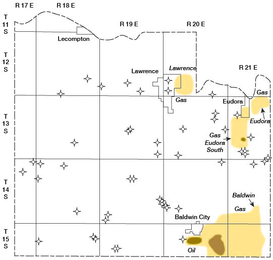
In 1955, oil production from 20 wells in two fields amounted to 10,853 barrels. The Baldwin field has produced oil since 1919, and in 1955 there were 19 wells producing from the Squirrel sand in the upper part of the Cherokee Group at a depth of about 800 feet. One well in the Eudora South field is reported to have produced 72 barrels of oil from the Squirrel sand at a depth of about 700 feet (Goebel, Hornbaker, Atkinson, and Jewett, 1956).
Gas in commercial quantities has not been produced for several years, but gas for local farm consumption is obtained from some wells in the eastern half of the county, principally from the Squirrel sand, 700 to 800 feet deep, but also from sand in the Pleasanton Group at a depth of about 340 feet. Figure 3 shows the location of oil and gas fields and the dry holes that have been drilled outside the producing areas prior to January 1957.
Although no oil or gas has been found in rocks older than the Cherokee Group, known structural conditions suggest that stratigraphic traps may exist in Devonian or Viola (Kimmswick) rocks (Jewett, 1954).
Figure 3—Map of Douglas County showing location of oil and gas fields and dry holes drilled outside of producing areas prior to January 1957.
Coal
Bowsher and Jewett (1943) report that coal has been mined in 21 different operations in Douglas County, the first coal having been mined during settlement of the area in the 1860's. The principal coals mined in the past have been the Blue Mound coal in the Stranger Formation and the Lower Williamsburg coal in the Lawrence Shale. In addition, at least three other named coal beds have been recognized, namely the Upper Williamsburg coal near the top of the Lawrence Shale and the Upper and Lower Sibley coals in the Stranger Formation.
In the Blue Mound area (sec. 21, 22, 27, and 28, T. 13 S., R. 20 E.) three coals are present in the Tonganoxie Sandstone member of the Stranger Formation. According to Whitla (1940) the lowest of these, the Blue Mound coal, is 12 to 14 inches thick and lies approximately 55 feet below the top of the Tonganoxie Sandstone member. Two other coal beds, measuring 6.5 and 3 inches thick, respectively, lie approximately 37 feet and 55 feet above the Blue Mound coal; these are the Lower and Upper Sibley coals.
The Lower Williamsburg coal has been mined locally on several farms in T. 13 and 14 S., R. 18 E., and is reported to range in thickness from 8 to 14 inches.
The Upper Williamsburg coal, because of its thinness, has not been mined in Douglas County. In the vicinity), of Lone Star Lake a coal bed 0.5 to I foot thick, believed to be the Upper Williamsburg, occurs about 10 feet below the top of the Lawrence Shale. The Williamsburg coals are chiefly in the southern part of the county.
The Douglas Group coals have not been mined for many years and most of the former workings are now obscure. Bowsher and Jewett (1943) gave the mine locations and history of production of the Douglas coals in detail.
Sand and gravel
Arkosic sand and gravel is dredged from Kansas River just below the Bowersock mill and dam at Lawrence. This plant, operated by the Bowersock Mills & Power Co., is the only commercial producer of sand and gravel in the county. Several small sand and gravel pits in Kansan glaciofluvial deposits have been operated intermittently in other parts of the county, as at Shank Hill in sec. 26, T. 13 S., R. 19 E. Because these deposits are not well. sorted and may contain large boulders and cemented zones, the pits are difficult to operate.
A large sand and gravel pit was operated at Lakeview during construction of the Kansas Turnpike. Dredging in the ancient meander of Kansas River that now forms Lakeview Lake removed several thousand yards of sand and gravel and created a deep hole in the former uniformly shallow lake.
The chief use of sand and gravel produced locally is for paving and construction. Bowdish and Runnels (1952) demonstrated that the Kansas River sand can be used to produce a nearly pure feldspar product of commercial grade and a high-quality silica sand having less than 0.03 percent Fe2O3 suitable for use in glass, glass fiber, and the ceramic industry.
Limestone
The outcropping limestones have been quarried and used for concrete and other aggregate, crushed rock for road metal, agricultural limestone, riprap, subgrade and embankment material, and building stone.
Three limestones are currently being quarried and crushed for concrete aggregate, road metal, and agricultural lime. Of these the Plattsmouth Limestone member of the Oread Limestone is the most extensively quarried, chiefly because it is relatively thick (commonly about 18 feet), has desirable physical properties, and is found near the principal areas of use. Several quarries have produced limestone from the Toronto Limestone member of the Oread Limestone in the area north of Baldwin, where it locally is 9 to 12 feet thick. The Stoner Limestone member of the Stanton Limestone has been quarried 1 mile northeast of Eudora and along Little Wakarusa Creek about 2 1/4 miles south of Eudora, where it is 16 or 17 feet thick. Chemical analyses of rock samples from some of the important limestone ledges are given in Table 3.
No quarries are operated for the production of dimension stone, but several ledges have been quarried and the stone used locally for building. The Toronto Limestone member of the Oread Limestone was quarried along the outcrop where little or no overburden was present, at several places just west of the Kansas University campus and on the campus. It weathers brown and is durable, as is evident in the several University buildings constructed of the Toronto Limestone. It does not withstand weather quite as well as the more widely used Cottonwood Limestone member of the Beattie Limestone and the Fort Riley Limestone member of the Barneston Limestone used in buildings and bridges throughout eastern Kansas. Several structures in Baldwin utilize the Haskell Limestone as building stone. The gymnasium shows the pleasing gray color and weathering characteristics of this stone.
The Clay Creek Limestone member of the Kanwaka Shale, the, Spring Branch and Avoca Limestone members of the Lecompton Limestone, and the Ozawkie Limestone member of the Deer Creek Limestone have been used in the construction of small bridges, rural schools, and numerous farm buildings in the area but have not been quarried extensively. The Westphalia Limestone, because of its thinness and smooth surfaces, has been quarried locally for flagstone. Projects requiring riprap for road, bridge, or railroad fill and embankment protection have utilized the nearest local limestone available in sufficient quantities and having the necessary physical properties.
Sandstone
Massive beds of the Ireland Sandstone member of the Lawrence Shale and the Tonganoxie Sandstone member of the Stranger Formation were quarried locally for building stone in the late 19th and early part of the 20th centuries. Where used as building stone the rock, generally all six faces, has been sawed into rectangular blocks. Although relatively soft when cut, it commonly develops a hard crust on exposure to weathering, is durable, and has a pleasing tan or gray-tan color.
Friable deposits of the Ireland Sandstone member have been utilized recently as subgrade material in local road construction.
Zinc and lead
Haworth (1904) reported that a mining company was formed in 1901 to mine lead and zinc ore in Douglas County, after farmers living south and west of Lawrence discovered fairly large crystals of both ores in several localities in the area, but no mining was done. Several farmers report that small amounts of ore recovered from streambeds and shale banks on their farms were smelted, and the metal sold at Lawrence. No reports of zinc or lead having been marketed commercially have been verified, however.
The mined ore was chiefly sphalerite containing small amounts of galena. It occurs with calcite in calcareous concretionary masses and septaria in some of the shale beds. During this investigation it was found to be most abundant in the Lawrence-Snyderville Shale where the Toronto Limestone member of the Oread is absent, in the southern part of Douglas County. Similar concretions are found in other Pennsylvanian shales in other areas also. Nowhere in eastern Kansas are these concretions of economic importance, however.
Ceramic materials
Material suitable for the manufacture of brick and tile is abundant in eastern Kansas in the Pennsylvanian shales, chiefly illitic shales. Recent studies by Plummer and Hladik (1948, 1951) have indicated that both lightweight and dense constructional aggregates can be manufactured from Pennsylvanian shale and Pleistocene silt, which crop out in Douglas County. Both the Pennsylvanian and the Pleistocene materials produce ceramics that are red or dark in color.
The Lawrence Vitrified Brick & Tile Co. operated a plant at the north end of Mississippi Street in Lawrence (NE sec. 25, T. 12 S., R. 19 E.) from 1899 to the 1920's. This plant manufactured building tile, silo blocks, face brick, paving brick, and common brick. Much of the paving brick in Lawrence streets was manufactured here. Silt, sand, and gravel from Kansan terrace deposits adjacent to the Plant and shale from the lower part of the Lawrence Shale were combined in various proportions to produce the desired tile or brick.
Clayey parts of the Lawrence Shale excavated on the University of Kansas campus have been used with good results by the pottery classes in the Department of Design for modelling, throwing, and slip casting of pottery (Norman Plummer, personal communication).
Economic value of mineral resources
Schoewe (1956) lists the minerals produced commercially in 1955 as sand, gravel, stone, and oil, and their total value as about $194,600. Oil was valued at about $30,600, and the sand, gravel, and stone were valued at about $164,000. Non-commercial production of gas was not included.
Prev Page--Introduction || Next Page--Subsurface Stratigraphy
Kansas Geological Survey, Geohydrology of Douglas County
Web version Aug. 1999. Original publication date Dec. 1960.
Comments to webadmin@kgs.ku.edu
The URL for this page is http://www.kgs.ku.edu/General/Geology/Douglas/geog01.html