![]()
Prev Page--Source and Occurrence || Next Page--Recovery and Utilization
Ground Water, continued
Ground-water Recharge
Recharge is the addition of water to the ground-water reservoir and may be accomplished in several ways. All ground water available to wells in Cheyenne County is derived from precipitation falling as rain or snow within the county or within adjacent areas to the west, southwest, and south. Part of the water that falls as precipitation is carried away as surface runoff and is lost to streams, part evaporates, and some is absorbed by plants and returned to the atmosphere as water vapor by transpiration.
The remainder percolates slowly down through the soil and underlying strata and part of it eventually reaches the water table. Once the water becomes part of the body of ground water, it moves in the direction of the slope of the water table to be discharged later in any of several ways described elsewhere.
The quantity of water that is carried away by surface runoff depends upon several factors: the duration and intensity of rainfall, the slope of the land, the type and condition of the soil, and the vegetation. Runoff resulting from torrential rains is much greater than that resulting from gentle rains, and steep slopes permit greater runoff than gentle slopes. In general, runoff is greater in places of tightly compacted fine-grained soil than in places of loose sandy soil. Runoff is also greater during winter rains that occur at times when the ground is frozen and is impervious to infiltration. The velocity of surface runoff is reduced by a suitable vegetative cover and water has a better chance to seep into the soil. Modern methods of land terracing and contour farming tend not only to reduce the erosion of valuable soil but also to reduce runoff and therefore increase the infiltration of water into the soil and, when more than sufficient water is available to replenish soil moisture, to the water table.
The amount of water that leaves Cheyenne County as surface runoff is not large. In the water year 1946-47, which includes the period October, 1946, through September, 1947, the amount of water that passed the stream-gaging station on South Fork near the Kansas-Colorado State line was 36,660 acre-feet (U. S. Geol. Survey, 1950, pp. 559-560). During the same period, 61,750 acre-feet of water passed the gaging station just north of the Kansas-Nebraska State line. Therefore, 25,090 acre-feet was added to South Fork in Cheyenne County. The drainage area contributing to the runoff of 25,090 acre-feet is 690 square miles. Converted to inches per square mile, the runoff is 0.68 or about 2.5 percent of 27.08 inches, the precipitation in Cheyenne County during this period. These computations are made for the area drained by South Fork but comparable values could be obtained for the other major streams in Cheyenne County were data available. Very little of the water that reaches the surface as precipitation in Cheyenne County is lost to direct surface runoff.
Much of the water that reaches the surface as precipitation is lost by evaporation and transpiration and never reaches the water table. A large percevtage of the precipitation falls during the period from May through September when temperatures are high, humidity is low, winds are relatively high, and consequently the rate of evaporation is high. No figures regarding the annual rate of evaporation in Cheyenne County are available, but the average rates of evaporation from a free water surface (U. S. Department of Agriculture, Bureau of Plant Industry type pan) for the months of the growing season based on a 38-year record from 1913 to 1951 at Colby, Thomas County, experiment station are: April, 4.93 inches; May 6.28 inches; June, 7.72 inches; July, 9.29 inches; August, 8.23 inches; and September, 6.30 inches.
During the growing season, absorption and transpiration by vegetation consume a large percentage of the rainfall during this period. The quantity of water lost by transpiration varies widely with different species of plants. The use of water by plants may be shown by stating the quantity of water consumed to produce a unit weight of dry plant matter. This quantity is designated as the transpiration ratio. The transpiration ratios in pounds of water per pound of dry matter for several plants common in Cheyenne County are as follows: wheat, 375; corn, 345; alfalfa, 829; buffalo grass, 308; and sunflower, 577 (Foster, 1948, p. 286).
The water that escapes runoff, evaporation, and transpiration percolates into the soil. When the soil contains enough water to satisfy the soil-moisture requirement, any excess water may move downward to the zone of saturation. Although a considerable amount of rain may fall during the summer months, the increased evaporation and transpiration may use most of the water that enters the soil, and soil moisture may be nearly depleted at the end of the growing season. During the fall and winter, when evaporation and transpiration are at a minimum, the soil may again become sufficiently saturated to permit recharge if precipitation is adequate.
Upland Areas
Ground-water recharge in the upland areas of Cheyenne County is probably very slight. The uplands are covered by a mantle of wind-blown silt or loess (Sanborn formation) which reaches a maximum of 180 feet in thickness in the northern part of the county. In certain areas the Sanborn formation contains a large amount of fine to medium sand and may permit a larger amount of infiltration of precipitation than areas where it is composed mainly of silt. An opportunity for recharge is offered also in the area of dune sand in places on the slopes south of South Fork. Rodent burrows and sod cracks developed during dry seasons may also be avenues of additional recharge. Generally, the loess is rather porous but nearly impermeable.
Some of the upland areas, particularly the area northeast and southwest of Bird City, have many shallow undrained depressions which collect water and form temporary ponds after heavy rains (Pl. 1). The water in some of these ponds disappears quickly, but in others, water may remain for weeks or months. Probably a certain amount of recharge takes place by seepage from these ponds.
Streams
Ground-water recharge is derived more from water in the stream channels than from the infiltration of water through the upland deposits of Cheyenne County. Many of the smaller streams, particularly Little Beaver Creek and most of the southern tributaries to South Fork, lie above the water table and flow only for short periods after heavy rainfall. Most of the small streams contain sandy alluvial deposits through which water may travel as it moves downward to the water table. Recharge from these stream channels takes place only during and after heavy rains when the streams contain water. Although South Fork generally receives water from the ground-water reservoir, the river recharges the ground water occasionally.
Subsurface Inflow
Much ground-water recharge in Cheyenne County results from subsurface inflow. Plate 1 indicates that ground water enters the county from the west, southwest, and south, and some of the water that reaches the water table in counties adjacent to the west and southwest eventually moves into Cheyenne County. The cross sections in Figures 5 and 6 and the map showing the thickness of water-bearing materials (Fig. 9) indicate that little or no recharge occurs along the northwest border of the county by subsurface inflow except in the alluvium of Arikaree River.
Fig. 9--Map showing the saturated thickness of the Tertiary and Quaternary deposits in Cheyenne County.
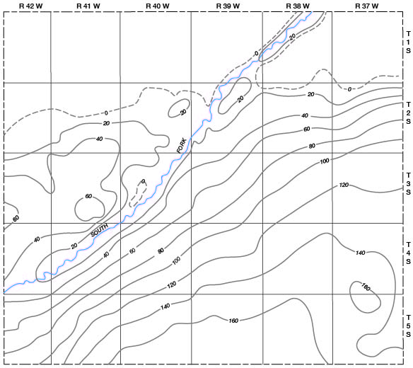
The thickness of water-bearing materials ranges from about 90 to 175 feet along the southern border of the county and from about 35 to 90 feet on the southwestern edge of the county. Considerable recharge from subsurface inflow occurs in these areas.
Irrigation
In areas of extensive irrigation ground-water recharge may occur by seepage from ditches and by downward percolation after water has been spread on the fields. In the vicinity of a pumped well the water table may decline, and in the area where the water returns to the ground-water body the water table may rise. In Cheyenne County little irrigation is practiced and the amount of recharge from this source is negligible. Should the amount of irrigation in the vicinity of South Fork be increased significantly, the water table in the alluvium along the river probably would rise.
Ground-water Discharge
Discharge of subsurface water is divided into vadose-water discharge or discharge of soil water not derived from the zone of saturation, and ground-water discharge or discharge from the saturated zone (Meinzer, 1923a, p. 48). Discharge of soil water is accomplished by the direct evaporation of water contained in the soil and by discharge of water from growing plants by transpiration. This consumption of water reduces ground-water recharge because the deficiency of soil moisture must be replenished before recharge can take place. Ground-water discharge may take place through evaporation and transpiration, by discharge from wells and springs, by seepage into streams, and by underground movement to adjacent areas.
Transpiration and Evaporation
The roots of plants may draw water direction from the zone of saturation or the capillary fringe and discharge the water into the atmosphere by the process of transpiration. The rate of withdrawal of ground water by transpiration varies mainly with the type of plants, the depth to the water table. the climate, and the season of the year. The roots of ordinarny plants and grasses commonly do not extend to depths of more than a few feet for water but certain plants are known to extend their roots to considerable depths. Alfalfa may obtain ground water from depths of 20 to 3O feet below the surface, and alfalfa roots have been reported to extend 66 to 129 feet in extreme cases (Meinzer, 1927, p. 55).
The loss of ground water through direct evaporation and transpiration from the water table is high in certain areas, particularly in the valleys of South Fork and Arikaree River and their tributaries and in Beaver Creek Valley. In areas where the depth to water exceeds 20 feet the amount of evaporation and transpiration from the water table probably is small.
Springs
In Cheyenne County some ground water is discharged from springs. Many small springs are found in the county, especially in some of the small valleys tributary to South Fork at the contact between the Pierre shale and the Ogallala formation. Water moving laterally at the base of the Ogallala formation on the top of the impermeable Pierre shale flows or seeps out at the surface where the top of the Pierre shale is exposed. In 1950 parts of Big Timber, Spring, Plum, Cherry, and Hackberry Creeks contained small spring-fed streams. These streams and the springs that feed them are locally important sources of water for stock.
Springs occur along South Fork where the water table intersects the ground surface. Water at two farmhouses in sec. 16, T. 4 S., R. 41 W. is supplied by such springs, and other springs in the same section supply abundant water for stock.
Springs in the SW sec. 10, T. 3 S., R. 40 W. issue from cracks in the Pierre shale a few feet above river level on the north bank of South Fork. The water probably enters the shale a short distance upstream where the shale is beneath the surface of the water in the river. The water moves in the shale through cracks and along bedding planes and emerges at the surface as seeps or springs.
Seepage into Streams
Ground water adds to the flow of South Fork, Arikaree River, and Beaver Creek where the stream levels are generally below the level of the water table. Little Beaver Creek and most of the tributaries of both the Arikaree and South Fork are above the water table and do not receive water from the zone of saturation.
Wells
Most of the domestic, municipal, stock, railroad, and irrigation water supplies in Cheyenne County are derived from wells, but the amount of ground water discharged by pumping is a small fraction of the total amount of ground water discharged. About 700 to 800 acre-feet of ground water is discharged annually by pumping from wells in Cheyenne County.
Subsurface Outflow
The water-table contours on Plate 1 indicate that water is moving out of the county beneath the surface to the east and northeast. The saturated thickness of water-bearing materials is more than 100 feet along much of the eastern border of the county, and hence a large amount of ground-water discharge takes place as subsurface outflow. Data on permeability and transmissibility are not adequate to permit estimating either subsurface inflow into or subsurface outflow from the county.
Prev Page--Source and Occurrence || Next Page--Recovery and Utilization
Kansas Geological Survey, Geology
Placed on web Aug. 8, 2008; originally published April 1953.
Comments to webadmin@kgs.ku.edu
The URL for this page is http://www.kgs.ku.edu/General/Geology/Cheyenne/05_gw2.html