![]()
Prev Page--Contents || Next Page--Geography
Introduction
Purpose and Scope of the Investigation
The study of the geology and ground-water resources of Cheyenne County, Kansas, is one of a series begun in Kansas in 1937 by the United States Geological Survey and the State Geological Survey of Kansas with the cooperation of the Division of Sanitation of the State Board of Health and the Division of Water Resources of the State Board of Agriculture.
These detailed surveys of county areas or major stream valleys are made to evaluate both the quantity and quality of ground water and the possibilities of increasing the use of available ground water.
Ground water is a principal natural resource of Cheyenne County. Nearly all public, domestic, and stock water supplies are obtained from wells. Ground water is used to some extent for irrigation, a use which probably will increase in the future. Although the danger of seriously depleting the supply of ground water is slight at the present rate of pumping, there is a definite need for an adequate understanding of the quality and quantity of the available supply, of where additional supplies can be obtained, and of what may be necessary to safeguard them from depletion.
The field work upon which this report is based was done during the summer and fall of 1950. During this period test holes were drilled, private and municipal wells were measured, water samples were collected, and the surface and subsurface geology of the county were studied and mapped.
The investigation was made under the general administration of A. N. Sayre, Chief of the Ground Water Branch of the United States Geological Survey, and under the immediate supervision of V. C. Fishel, District Engineer in charge of ground-water studies in Kansas.
Location and Extent of the Area
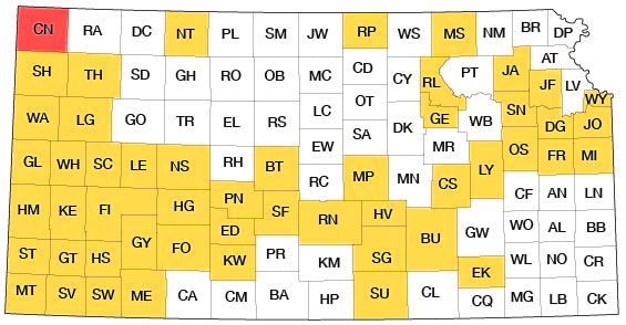
Cheyenne County is in the High Plains section of the Great Plains physiographic province. The county is in the northwest corner of the State and is bounded on the north by Dundy County, Nebraska, on the east by Rawlins County, Kansas, on the south by Sherman County, Kansas, and on the west by Yuma County, Colorado (Fig. 1). Cheyenne County contains all or part of 30 townships (from T. 1 S. to T. 5 S. and from R. 37 W. to R. 42 W.) having an area of approximately 1,027 square miles.
Fig. 1--Index map of Kansas showing area described in this report and areas covered by other online geologic reports, as of Aug. 2008. For additional information, please visit the KGS Geologic Maps of Kansas Page.
Methods of Investigation
The data upon which this report is based were obtained during about 5 months in the summer and fall of 1950. In the spring of 1946 Delmar W. Berry made an inventory of wells in the valley of the South Fork Republican River, which is referred to in this report for brevity as South Fork. Most of the irrigation wells in the valley at that time were included in the inventory. He also established 22 observation wells in and near the valley, and semimonthly measurements of most of these wells have been made since 1946.
Data have been obtained on 361 wells and 1 spring, most of the wells being measured with a steel tape to determine their depth and the depth to water level. Well owners and drillers were interviewed concerning yield of wells and type of water-bearing materials. A pumping test was made on an irrigation well to determine the yield of the well and the permeability of the water-bearing materials. Samples of water were collected from 17 wells and 1 spring the samples were analyzed in the Water and Sewage Laboratory of the State Board of Health at Lawrence by Howard A. Stoltenberg, chemist.
During the investigation the surficial geology was studied and the geologic map (Pl. 1) was prepared. The character of the material beneath the land surface was determined by drilling 41 test holes through the entire thickness of water-bearing materials into the underlying Cretaceous Pierre shale. These test holes were drilled with the portable hydraulic-rotary drilling machine owned by the State Geological Survey of Kansas and operated by William T. Connor and Earl L. Gorman. Laurence E. Gnagy collected and studied samples of the well cuttings in the field and prepared logs of the test holes. The altitude of the ground surface at the test holes and of the measuring points of the wells inventoried in 1950 were determined by level parties headed by Woodrow W. Wilson and Charles K. Bayne. Altitudes of measuring points of wells inventoried in 1946 were determined by personnel of the U. S. Bureau of Reclamation.
The wells shown on Plates 1 and 2 were located within the sections by the use of an odometer. The base map used in these plates was prepared by Woodrow W. Wilson from a county map compiled by the Soil Conservation Service, U. S. Department of Agriculture. The locations of the roads were corrected, where necessary, from observations in the field and from topographic maps of the U. S. Geological Survey. The geologic mapping was done on a map obtained from the Soil Conservation Service, and drainage was adapted from maps issued by the Soil Conservation Service.
Previous Investigations
The earliest reference to Cheyenne County is by Hay (1895) who discussed the source and quantity of ground water and the geology and water-bearing formations of a part of the Great Plains along the Kansas-Colorado State line and mentioned early attempts to irrigate in the county with water from wells and from South Fork. Several geologic cross sections were included in the report. A report by Newell (1896) contained records of 43 wells in Cheyenne County.
Three papers by Haworth in 1897 (1897, 1897a, 1897b) mentioned South Fork in Cheyenne County, and one of these (1897b, p. 99) noted the diversity of ground-water conditions in the county. Logan (1897) discussed the Pierre shale in Cheyenne County, and included a geologic cross section from St. Francis to Arikaree River. Johnson (1901, 1902) made special reference to the source, availability, and use of ground water in western Kansas, and Darton (1905, p. 292) briefly discussed geologic and hydrologic conditions in Cheyenne County. Parker (1911) included an analysis of water from a well at St. Francis, and Wolff (1911) made a detailed study of groundwater conditions along South Fork near St. Francis. Haworth (1913) also discussed the South Fork.
Elias's (1931) report on the geology of Wallace County described in detail several geologic formations that crop out in Cheyenne County. A report on the geology of Rawlins and Decatur counties (Elias, 1937) devoted a section to deep-well irrigation south of Bird City in Cheyenne County and Landes (1937) mentioned briefly the water supplies. In 1940 Moore and others (1940) prepared a generalized report on the ground-water resources of the State. A report on the geology and ground-water resources of Sherman County, which borders Cheyenne County on the south, is now in press (Prescott, in press).
Well-numbering System
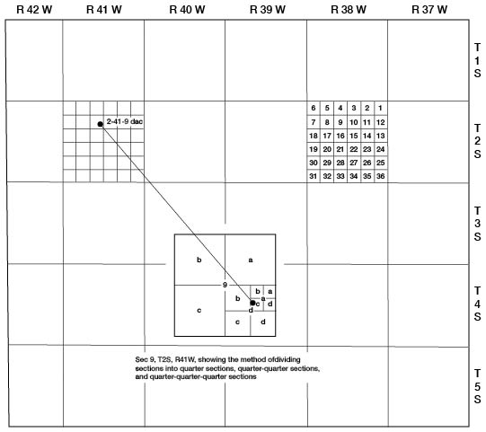
The well and test-hole numbers used in this report give the location of wells according to General Land Office surveys. The well number is composed of township, range, and section numbers, followed by lower-case letters to indicate the subdivision of the section in which the well is located. The first letter denotes the quarter section, the second letter denotes the 40-acre tract, and the third letter indicates the 10-acre tract. The 160-acre, 40-acre, and 10-acre tracts are designated a, b, c, or d in a counterclockwise direction, beginning in the northeast quarter. When two or more wells are located within a 10-acre tract, the wells are numbered serially according to the order in which they were inventoried. An example of the well-numbering system is given in Figure 2.
Fig. 2--Map of Cheyenne County illustrating the well-numbering system used in this report.
Acknowledgments
I am indebted to many residents of Cheyenne County who assisted in this investigation by granting permission to measure their wells and who supplied data on local geology and ground water. Special thanks are extended to owners of irrigation wells who permitted pumping tests to be made, and to Ralph A. Crawford, well driller from St. Francis, who furnished information. Thanks are also extended to Grover Rogers of Bird City and Harold Miller of St. Francis, who gave information about the Bird City and St. Francis municipal supplies.
The manuscript for this report has been reviewed by several members of the Federal and State Geological Surveys; Robert Smrha, Chief Engineer, and George S. Knapp, Engineer, of the Division of Water Resources of the Kansas State Board of Agriculture; and Dwight F. Metzler, Director, and Willard O. Hilton, Geologist, of the Division of Sanitation of the Kansas State Board of Health. The illustrations were drafted by Woodrow W. Wilson.
Prev Page--Contents || Next Page--Geography
Kansas Geological Survey, Geology
Placed on web Aug. 8, 2008; originally published April 1953.
Comments to webadmin@kgs.ku.edu
The URL for this page is http://www.kgs.ku.edu/General/Geology/Cheyenne/02_intro.html