Prev Page--Geography || Next Page--Ground Water
General Geology
Summary of Stratigraphy
[Note: The geologic classification and nomenclature of this report follow the usage of the State Geological Survey of Kansas and differ somewhat from those used by the U. S. Geological Survey.]
The rocks cropping out in Cheyenne County are sedimentary and range in age from late Cretaceous to Recent. The areal distribution of their outcrops is shown on Plate 1.
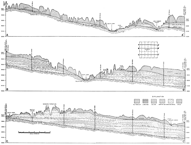
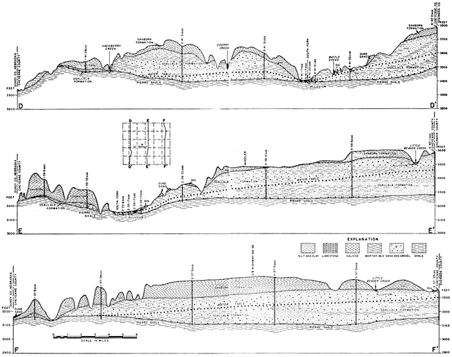
The Pierre shale of late Cretaceous age is the oldest geologic formation cropping out in Cheyenne County. The formation underlies the entire county and crops out along South Fork and Arikaree River and along valleys tributary to these streams. The Ogallala formation of Tertiary (Pliocene) age lies above the Pierre shale in much of the county, but in places the Ogallala is very thin or has been removed by erosion. The Ogallala crops out along many stream valleys, but in the uplands it generally is mantled by a thick deposit of wind-blown silt (loess), the Quaternary (Pleistocene) Sanborn formation. Dune sand of late Pleistocene age covers an area south of South Fork, and alluvial deposits along most of the streams constitute the most recent deposits in the area. Table 2 summarizes the character and ground-water supply of the geologic formations. The stratigraphic relationships of the formations are shown in the geologic cross sections (Figs. 5 and 6).
Table 2--Generalized section of the geologic formations in Cheyenne County, Kansas. Classification of the State Geological Survey of Kansas.
| System | Series | Formation | Thickness (feet) |
Character | Water Supply |
|---|---|---|---|---|---|
| Quaternary | Pleistocene | Alluvium | 0-40 | Sand, gravel, and silt comprising stream deposits along South Fork and most of the smaller streams. Deposits along South Fork generally coarser than along small streams. | Yields moderate supplies of water to wells along South Fork and small amounts in smaller stream valleys, except where deposits are above water table; some irrigation wells in South Fork Valley obtain water from alluvium. |
| Dune sand | 0-20 | Sand, fine to coarse; in places contains very coarse sand. | Generally lies above the water table and yields no water to wells but it is important as a catchment area for ground-water recharge to adjacent and underlying formations. | ||
| Sanborn | 0-180 | Silt, tan to liglit-brown; in places is very sandy and in places contains sand and gravel at the base. | Generally lies above the water table but in places may yield a small amount of water probably from Crete sand and gravel member at the base of the formation. | ||
| Tertiary | Pliocene | Ogallala | 0-290 | Sand, gravel, and silt, predominately calcareous; may be consolidated or unconsolidated; contains caliche beds and a limestone bed. | Yields moderate to large supplies of water to wells in much of the county; supports a few irrigation wells; formation is thin to absent in northern third of county and there yields small amounts of water or no water. |
| Cretaceous | Gulfian | Pierre shale | 900-1400 | Shale, tan, and light- to dark-gray. | Not known to yield water to wells in Cheyenne Co. |
Fig. 5--Geologic cross sections in Cheyenne County along lines A-A', B-B', and C-C'. A larger version of this figure is available.
Fig. 6--Geologic cross sections in Cheyenne County along lines D-D', E-E', and F-F'. A larger version of this figure is available.
Geomorphology
The development of the present topography in Cheyenne County is a result of events in Pliocene and Pleistocene times. During early Tertiary time the Rocky Mountains were uplifted extensively and streams flowed eastward from the mountains across the Great Plains. While deposition was occurring further north, the western Kansas area was being eroded. By Pliocene time conditions were reversed, possibly owing to differential uplift of the land, and streams from the Rocky Mountains laid down thick deposits of sand, gravel, silt, and clay over the High Plains of Kansas. By the end of the depositional period the erosional plain in the Rocky Mountain region merged with the aggradational plain in the Great Plains. Near the end of Ogallala time, when stream gradients were low and stream channels became choked with sediments, probably several small lakes were formed. A fresh-water limestone, the "Algal limestone," was deposited in the waters of these shallow lakes.
Early in Pleistocene time the existing streams (probably South Fork and Arikaree River in Cheyenne County) were rejuvenated and began to cut through the Pliocene deposits and where the Ogallala was thin, into the Pierre shale. Later, presumably by Illinoian time, the valleys were alluviated with deposits of the Crete sand and gravel member of the Sanborn formation. Another period of erosion followed and most of the Crete, except a few remnants along South Fork and Arikaree Valleys, were removed. Alluviation followed this period of erosion and South Fork and Arikaree River continue to deposit small amounts of sediment at the present time.
During Illinoian and early Sangamonian time silt was carried in and deposited on the uplands and slopes by winds, forming the Loveland silt member of the Sanborn formation. In late Sangamonian time the Loveland silt member was weathered to form the Sangamon (formerly called Loveland) soil. The Loveland silt member is not widespread in Cheyenne County. After the close of the Sangamon weathering period the Peoria silt member of the Sanborn formation was deposited in a thick nearly continuous blanket over the county. Overlying the Peoria are a few scattered patches of the Bignell silt member of the Sanborn formation. These deposits, and dune sand south of South Fork, attest to the recurrence of eolian deposition during late Pleistocene time.
During Recent time the county has undergone considerable erosion, which has formed much of its present topography. Several of the small streams have cut deeply into the Ogallala formation, and some of the tributaries to the Arikaree and South Fork have cut into the Pierre shale. Vertical downcutting has been particularly active on the north border of the county. In this area the Sanborn formation is more than a hundred feet thick, and because of its inability to resist erosion it has been very greatly dissected (Pls. 3B, 3C, and 4A). The Ogallala formation, being very thin or absent, in this area, has offered very little resistance to erosion, and deep canyons have been cut through the loess into the Pierre shale. In other areas the loess cover has been modified by the action of sheet and rill wash and soil creep. Some slopes are covered by deposits that have moved from the uplands by these processes.
During Recent time many shallow depressions, ranging in diameter from a few tens of feet to more than a quarter of a mile, have developed on the uplands, particularly in the Bird City area. Most of the depressions collect water during periods of heavy rainfall and hold the water until it has evaporated or percolated into the ground.
Prev Page--Geography || Next Page--Ground Water
Kansas Geological Survey, Geology
Placed on web Aug. 8, 2008; originally published April 1953.
Comments to webadmin@kgs.ku.edu
The URL for this page is http://www.kgs.ku.edu/General/Geology/Cheyenne/04_rock.html

