![]()
Prev Page--Geology || Next Page--Recharge
Ground Water
Source
Portions of the following paragraphs on the source and occurrence of ground water have been adapted from Meinzer (1923, pp. 2-102). The reader is referred to his report for a more detailed treatment of the subject.
Water that exists beneath the surface of the earth is termed subsurface water. The part of subsurface water that is in the zone of saturation is termed ground water or phreatic water; subsurface water above the zone of saturation--that is, in the zone of aeration--is called suspended subsurface water or vadose water. Ground water is the water that supplies wells and springs.
Ground water that is available to wells in Cheyenne County is derived from precipitation falling as rain or snow within the area or within near-by areas to the west. Part of the water that falls as rain or snow is carried away as surface runoff into streams, part of the water may evaporate, and part is absorbed by plants and returned to the atmosphere as water vapor by the process known as transpiration. Water that escapes runoff, evaporation, and transpiration percolates slowly downward through the soil and underlying strata and eventually reaches the water table where it joins the body of ground water in the zone of saturation.
The ground water percolates slowly through the rocks in directions determined by the shape and slope of the water table. The shape and slope of the water table are controlled by topography, local variations in the quantity of recharge or discharge, and the stratigraphy and structure of the rocks. The ground water is discharged through springs or wells, by seepage into streams, or by transpiration and evaporation in bottom lands adjacent to the streams.
Occurrence
The rocks that form the crust of the earth generally are not entirely solid but contain numerous open spaces called voids or interstices. These interstices may contain either liquid or gas, such as water, oil, natural gas, and air. Different kinds of rocks vary greatly in the number, size, shape, and arrangement of their interstices, and hence in their water-bearing properties. The occurrence of ground water in any region is determined therefore by the geology of the region.
The interstices in rocks range from microscopic openings to large caverns found in some limestones and lava rocks. In most rocks the interstices are connected and water can move by percolation from one to another. In some rocks the interstices are largely isolated and water has little opportunity to percolate. The porosity of a rock is its property of containing interstices. Porosity is expressed quantitatively as the percentage of the total volume of the rock that is occupied by interstices.
Porosity determines only how much water a given rock can hold, not how much it can yield to wells. A rock is said to be saturated when its interstices are filled with water. Not all the water in a saturated rock is available to wells, because part of the water is held against the force of gravity by molecular attraction. In a fine-grained rock the molecular attraction is very great and only a small part of the water, or none at all, can be drained out by the force of gravity, whereas in a coarse sand or gravel having the same porosity only a small part is retained by molecular attraction and the remainder, acted on by gravity, becomes available to wells. Thus, for a given porosity and a given degree of assortment, a coarse-grained rock will yield more water to wells than a fine-grained rock. The amount of water that a rock will yield when saturated is known as the specific yield; the specific yield of a water-bearing formation is defined as the ratio of the volume of water that the saturated formation will yield by gravity, to its own volume. This ratio is often expressed as a percentage.
The permeability of a water-bearing material is its capacity for transmitting water under a hydraulic gradient and is measured by the rate at which the material will transmit water through a given cross section under a given difference of pressure per unit of distance. A bed of silt, clay, or shale may have as high a porosity as a deposit of coarse sand or gravel, but because of the small size of its interstices it may be almost impermeable.
In summary, the rate of movement of ground water is determined by the size, shape, quantity, and degree of connection of the interstices, and by the hydraulic gradient.
The coefficient of permeability, commonly expressed in Meinzer's units, is the rate of flow in gallons a day through a cross-sectional area of 1 square foot under a hydraulic gradient of 100 percent (loss of 1 foot of head for each foot the water travels) at a temperature of 60° F. The field coefficient of permeability is the same, except that it is measured at the prevailing temperature rather than at 60° F. The coefficient of transmissibility is defined as the number of gallons of water a day transmitted through each vertical 1 foot strip extending the saturated thickness of the aquifer under a unit gradient, at the prevailing temperature. The coefficient of transmissibility is equal to the field coefficient of permeability multiplied by the saturated thickness of the aquifer. Both permeability and transmissibility can be conveniently expressed, for field use, as the flow across a section 1 mile instead of 1 foot wide, under a gradient of 1 foot per mile instead of 1 foot per foot.
A pumping test was made on well 4-42-26bad to determine the permeability and transmissibility of water-bearing materials in Cheyenne County. The coefficient of transmissibility, based on this test, is about 175,000 gallons per day per foot and the field coefficient of permeability is about 5,500 gallons per day per square foot. These are high values, indicating a permeable and productive aquifer. This well had a yield of 560 gallons a minute with a drawdown of 27 feet after 6.5 hours of pumping.
The Water Table and Movement of Ground Water
The permeable rocks that lie beneath a certain level in Cheyenne County are generally saturated with water. These saturated rocks are said to be in the zone of saturation, and the upper surface of the zone of saturation when it is overlain by unsaturated permeable material is called the water table. The permeable rocks lying above the water table are said to be in the zone of aeration. Some of the water that enters the soil at the surface moves slowly by gravity down through the zone of aeration to the zone of saturation. The remainder of the water that enters the soil is used by transpiration and evaporation or is retained in the zone of aeration by molecular attraction. In fine-grained material the earth is always moist several feet above the water table, owing to capillarity, and this belt is called the capillary fringe. Water in the capillary fringe or in transit or storage in the zone of aeration is not available to wells.
Shape and Slope
The shape and slope of the water table in Cheyenne County are shown on Plate 1 by contour lines drawn on the water table. Water-table contour lines connect points of equal altitude and these lines show the configuration of the water surface just as topographic maps show the shape of the land surface. Ground water moves in the direction of maximum downward slope, which is at right angles to the contours.
The shape and slope of the water table are controlled by several factors. The causes for the irregularities of the shape and slope of the water table in Cheyenne County are: the configuration of the Cretaceous bedrock floor, discharge of ground water into streams, local differences in the permeability of water-bearing formations, and recharge of ground water by ephemeral streams.
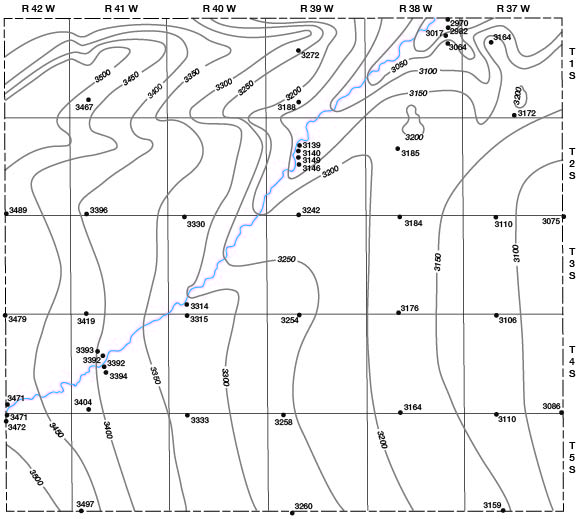
Ground water is moving through Cheyenne County in a general northeasterly or easterly direction (Pl. 1). The direction of movement of ground water in the county is determined to a considerable extent by the shape of the bedrock floor which, in general, slopes northeastward or eastward as does the water table (Fig. 7). Not all irregularities in the bedrock surface, however, are reflected in the shape of the water table.
Fig. 7--Map showing the location of test holes and the configuration of the top of the Pierre shale by means of contours.
The discharge of ground water into streams influences the shape and slope of the water table in Cheyenne County mainly along South Fork. The prominent upstream flexure of the water-table contours along the river is due largely to the effluent seepage (Fig. 8).
Fig. 8--Diagrammatic sections showing influent and effluent streams. (From O.E. Meinzer.)
The transmissibility of the water-bearing materials affects the slope of the water table. In general, the slope of the water table varies inversely with the transmissibility of the water-bearing materials. In areas where the water-bearing beds have a low transmissibility the slope of the water table steepens, but in areas of thicker or more permeable water-bearing beds the water table has a gentler slope and the contours are more widely spaced.
Recharge of ground water by ephemeral streams probably is not a significant factor in the formation of any permanent features in the water table of Cheyenne County. Ephemeral (intermittent) streams flow only after rains. Their channels lie above the water table and are dry most of the time. During periods of flow much water seeps into stream beds and moves downward to the water table, especially along Little Beaver Creek, where the alluvial deposits contain much sand and gravel. Such recharge causes a temporary mound or ridge to form in the water table, but such an irregularity is not permanent and is not shown on a small-scale map such as Plate 1. The movement of ground water from losing streams and to gaining streams is shown by the diagrammatic sections in Figure 8.
Water-table contours are not shown for the northern part of the county, where loess deposits are thick and outcrops of the Pierre shale are numerous. In this area the principal water-bearing formation in Cheyenne County, the Ogallala formation, is thin or absent. Both the loess and the Pierre shale have a very low permeability, and few wells drilled entirely in one or the other yield water. However, water can be obtained locally in this area, especially in draws containing alluvial or colluvial (slope-wash) deposits, but the water table is generally discontinuous.
Fluctuations of the Water Table
The water table does not remain stationary but fluctuates owing to variations in discharge and recharge and to a minor extent to such factors as changes in atmospheric pressure. The water table rises when the amount of recharge exceeds the amount of discharge and declines when discharge exceeds recharge.
Factors controlling the rise of the water table in Cheyenne County are the amount of water entering the county beneath the surface from areas to the west, the amount of precipitation that penetrates the ground and reaches the zone of saturation, and the amount of seepage that reaches the water table from surface streams. All these factors depend upon precipitation either in this county or in counties immediately adjacent to the west, southwest, and south.
Factors controlling the decline of the water table are the movement of ground water from the county to adjacent areas on the north and east, seepage into streams, loss of water through transpiration and evaporation where the water table is shallow, and pumping from wells.
Periodic water-level measurements were begun in Cheyenne County along South Fork in 1946 to obtain information concerning the fluctuations of the water table. The water-level measurements are published in annual water-supply papers of the U. S. Geological Survey (1128, 1158, and ensuing reports).
Prev Page--Geology || Next Page--Recharge
Kansas Geological Survey, Geology
Placed on web Aug. 8, 2008; originally published April 1953.
Comments to webadmin@kgs.ku.edu
The URL for this page is http://www.kgs.ku.edu/General/Geology/Cheyenne/05_gw.html