![]()
Prev Page--Subsurface Rocks || Next Page--Chemical Character, Regions
Part 3--Ground-water Resources of Chase County
by Howard G. O'Connor
Ground-water Resources
[Note: Although the ground-water section of this report is a cooperative product of the State Geological Survey of Kansas and the United States Geological Survey, the stratigraphic nomenclature used is of the State Geological Survey of Kansas.]
Source
Ground water is the water below the surface of the land that supplies water to wells and springs. In Chase County, ground water is derived largely from precipitation falling as rain or snow. Part of the water falling as rain or snow finds its way into the soil zone and percolates downward to the zone of saturation, part of the water enters the soil but is returned to the atmosphere by evaporation or transpiration without becoming a part of the ground-water body, and part of the water is carried away as surface runoff by streams.
The ground water percolates slowly through the rocks in a direction determined by the topography and geologic structure until it is discharged through wells or springs, through seeps directly into streams, or by evaporation and transpiration in the valley areas.
Principles of Occurrence
The rocks and surficial deposits that form the outer crust of the earth are not solid throughout, but contain numerous voids or interstitial openings which may contain air or water. The number, size, shape, and arrangement of these openings in the different kinds of rocks vary greatly, and the water-bearing characteristics of rocks vary accordingly. The mode of occurrence of ground water in any area, then, is primarily dependent upon the geology of the region.
According to their origin, the interstices of a rock may be classified as primary or secondary. Primary interstices are those which came into existence at the time the rocks were being formed. Secondary interstices are those developed by processes that affected the rocks after they were formed.
Secondary interstices, comprising joints, other fracture openings, and solution openings, are of primary importance in the consolidated rocks, whereas the primary or original interstices are of greater importance in the unconsolidated rocks with respect to water supplies, in Chase County as generally elsewhere.
The amount of water that can be stored in a rock is determined by the porosity of the rock. Porosity is the percentage of the total volume of a rock that is occupied by interstices. A rock is said to be saturated when all its interstices are filled with water or other liquids. The amount of water that a saturated rock formation will yield is known as the specific yield and may be defined as the ratio of (1) the volume of water which, after being saturated, it will yield by gravity to (2) its own volume. Because some water is left behind, held by capillarity, the specific yield is always less than the porosity.
The amount of water a rock formation may hold is determined by its porosity, but the rate at which it will yield water is determined by its permeability. The permeability of a rock formation is defined as its capacity for transmitting water under a hydraulic head and is measured by the rate at which the formation will transmit water through a given cross section under a given difference in head per unit of distance. A stratum of clay may have a porosity equal to that of a strata of sand, but, because of the small size of the interstices of the clay and the force of molecular attraction in fine-grained rocks, the clay may be almost impermeable under ordinary hydraulic gradients; however, a stratum of sand having an identical porosity may have a high permeability because of the relatively large interconnecting interstices which permit water to move through easily under the same hydraulic gradient.
Below a certain level in the earth's crust, the permeable rocks generally are saturated with water under hydrostatic pressure and are said to be in the zone of saturation. The upper surface of the zone of saturation is called the water table. All the rocks above the water table are in the zone of aeration, which ordinarily consists of three parts: the belt of soil water; the intermediate, or vadose zone; and the capillary fringe.
Unconfined Water
Unconfined or free ground water is ground water in the zone of saturation that does not have an impermeable or confining body restricting its upper surface and the upper surface of which is the water table. This surface is not a static level but is a sloping surface that shows irregularities on a subdued scale similar to those of a land surface. Changes in permeability and unequal amounts of recharge to and discharge from the ground-water reservoir also cause irregularities in the water table. In fine-grained granular materials the small openings above the water table are generally filled by capillary water for a distance of several inches to several feet above the water table, but the position of the water table is shown by the level at which water will stand in a well. In rock formations containing unconfined ground water in fissures, fractures, or solution channels, the zone of capillary water above the water table is generally thin.
Confined Water
Ground water is said to be confined if it occurs in permeable zones between relatively impermeable confining beds. Slightly permeable confining beds are probably much more abundant than impermeable confining beds and considered over a wide area it is probable that no bed is strictly impermeable.
In areas where water is confined by alternating permeable and impermeable beds, a well may pass through several zones of saturation, each of which has sufficient permeability to supply water to a well. Confined water in permeable formations tends to move in the direction of dip of the formation. The quality and the quantity of water obtainable from these confined beds varies considerably, even in short distances, because of changes in lithology and degree of weathering, and in the amount of fracturing and solution that have occurred.
Artesian conditions--The level at which water stands in wells may be called the piezometric or pressure-indicating surface. Where the top of the zone of saturation occurs in a permeable formation, the piezometrie surface coincides with the water table, and the water is said to be under normal pressure. If water is confined between relatively impermeable beds and the level at which water will stand in a well is below the top of the zone of saturation, the water is said to be under subnormal pressure; but if the level at which water will stand in a well is above the zone of saturation, the water is said to be under artesian pressure. An artesian well that flows at the land surface is a flowing artesian well.
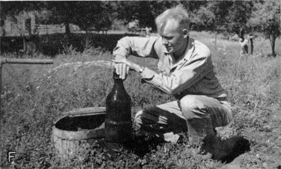
Areas of artesian flow--In Chase County there are two known areas where flowing artesian wells occur.
In one area three flowing wells were drilled in 1922, to a depth of somewhat more than 100 feet, on the William Selves ranch in the NE SE sec. 27, T. 20 S., R. 7 E. The northeasternmost, No. 20-7-27da3 (P1. 6F), of the three wells had sufficient head to flow water to the second story of a farmhouse adjacent to the well. Wells 20-7-27da3 and 20-7-27da2 each flow less than 1 gallon a minute and are not used. Well 20-7-27da1, the southeasternmost of the three flowing wells, is used to supply water for all domestic purposes at the Selves ranch. Table 6 includes a chemical analysis of the water from this well. The artesian flow from the well through a one-half inch pipe was measured as slightly more than 3 gallons per minute by A. R. Leonard and H. G. O'Connor. The total discharge from the three flowing wells in 1947 was approximately 500,000 gallons.
Plate 6F--Flowing artesian well (no. 20-7-27-da3) on William Selves ranch. (Photo by A.R. Leonard)
There are two flowing wells about 1 1/4 miles south of the Selves ranch on the James C. McNee ranch in the SW SE sec. 34, T. 20 S., R. 7 E., and NE NE sec. 3, T. 21 S., R. 7 E. These wells are reported by their owner to be approximately 100 feet deep.
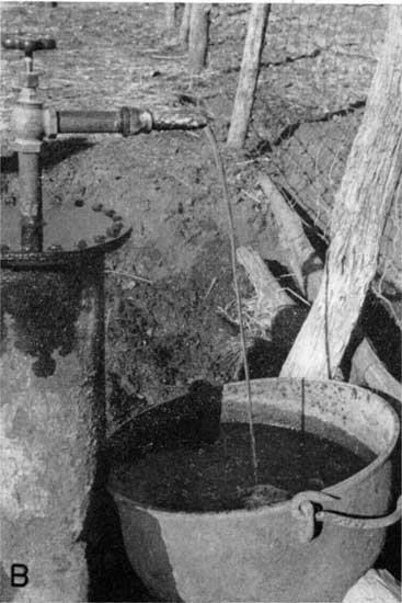
There is one flowing well on the Mildred Morse farm in the SE SE sec. 27, T. 22 S., R. 6 E. This well is reported to be 20 to 30 feet in depth and to have been drilled about 1937. The initial hydrostatic head was reported sufficient to force water approximately 13 feet above the land surface. In the fall of 1947 this well was flowing an estimated 5 gallons a minute through the well easing and was leaking around the outside of the casing, the discharge by leakage accounting for most of the flow (Pl. 6B).
Plate 6B--Morse flowing artesian well, SE SE sec. 27, T. 22 S., R. 6 E. (Photo by H.G. O'Connor)
Prior to the drilling of the Morse well, a well owned by School District No. 45 of Burns, Kansas, in the SW SW sec. 26, T. 22 S., R. 6 E., had flowed, but it ceased to flow when the Morse well was drilled. A chemical analysis of the water from the school well (22-6-26cc) is given in Table 7.
Ground-water Recharge
Recharge is the addition of water to the underground reservoir and may be accomplished in several ways. In Chase County local precipitation is the principal source of recharge, and lesser amounts are contributed by influent seepage from streams and ponds and by subsurface inflow from adjacent areas.
Recharge from Precipitation
In Chase County the normal annual precipitation is about 32 inches. The greatest amount occurs in the months of April to September, inclusive, during the growing season. The normal annual precipitation amounts to more than 500,000,000 gallons of water per square mile, but only a small part of this quantity reaches the zone of saturation. Of the precipitation, a part runs off directly, a part is discharged by evaporation and transpiration, and a part is added to (recharges) the ground-water reservoir, later being discharged into streams or by evaporation and transpiration.
Runoff, including both direct runoff and groundwater discharge into streams, accounts for only a small part of the precipitation except after prolonged or very heavy rains. According to records of the Division of Water Resources of the Kansas State Board of Agriculture, the annual net runoff in the drainage area of the Cottonwood River above Cottonwood Falls, Kansas, during the five years 1939 to 1943, inclusive, ranged from 0.96 inch in 1940 to 11.59 inches in 1941, and the average for the five-year period was 3.47 inches. If related to the precipitation records at Cottonwood Falls for the same period of time, a runoff of approximately 11 percent of the precipitation is indicated; this figure is probably somewhat higher than the average for a longer period of time because of the exceptionally high precipitation and runoff in 1941.
The amount of water lost by transpiration and evaporation depends upon the temperature, humidity, vegetative covering, wind velocity, depth to the water table below land surface, and the length of time the processes of evaporation have access to moisture. In Chase County the bulk of the water that does not run off into the streams, averaging probably a little less than 29 inches, is lost by transpiration and evaporation.
Seepage from Streams and Ponds
Streams contribute recharge to the unconsolidated alluvial material during times when stream level is above the level of the adjacent water table. After periods of flood, the water table in the alluvium of Cottonwood River valley and its major tributaries is frequently several inches to several feet higher than before the flood. The water, however, discharges rather quickly back into the streams after their levels decline.
Intermittent tributary streams, where they cross exposed permeable strata in the upland areas, contribute to the recharge of the stratified Permian rocks where structural conditions are suitable--that is, where the permeable strata dip away from, rather than toward, the contributing stream.
Ponds and lakes in the upland areas contribute small amounts of recharge, mostly to the surficial permeable rocks below the pond or lake but to some extent to permeable stratified rocks. The amounts contributed to the stratified rocks, however, are small.
Percolation from Outside the Area
Ground-water recharge by subsurface percolation in either the consolidated stratified rocks or unconsolidated rocks, or both, enters Chase County from adjacent areas. The amount of ground water added to the subsurface reservoirs by this means, however, is small. Also, it probably is balanced by water leaving the county in the same way.
Discharge of Subsurface Water
Discharge of subsurface water has been divided by Meinzer (1923, pp. 48-56) into ground-water discharge (discharge of water from the zone of saturation) and vadose-water discharge (discharge of soil water not derived from the zone of saturation). Ground water also moves out of Chase County by subsurface percolation in both the consolidated and unconsolidated rocks, eventually to be discharged by evaporation or transpiration or through springs and seeps or wells.
Evaporation and Transpiration
Water is lost to the atmosphere directly from the soil zone and zone of vadose water by evaporation. Also through the process of transpiration, plants discharge large quantities of water to the atmosphere from the vadose zone. The use of soil water is of great importance to agriculture for crops in most areas of Chase County are dependent on this type of water for growth, but significant amounts of ground water from the capillary fringe and, to a lesser extent, from the zone of saturation, are discharged by transpiration in all the valley areas by trees, alfalfa, and other plants.
In the upland areas considerable amounts of water from water-bearing limestone beds are transmitted into surficial slope deposits where the water is removed by evaporation and transpiration. Little or no ground water is lost to plants in the upland areas except by seepage along the outcrop of water-bearing limestones, as the uplands are almost entirely devoid of trees or other deep-rooted plants, the vegetative cover consisting almost entirely of native grasses.
Springs and Seeps
The flow of Jack Spring in sec. 25, T. 22 S., R. 7 E. (Table 6, P1. 6A) was measured on October 29, 1947, during a low flow stage by W. W. Wilson and determined to be discharging ground water at the rate of 95 gallons per minute, or about 50 million gallons per year. During much of the year, the rate of discharge is considerably more than 95 gallons per minute. This was the largest spring measured in Chase County, but numerous other springs, mostly of smaller size, were noted. The rocks included within the Chase group, especially in the southwest quarter of the county, supply water to the largest, most dependable springs. Springs in other sections of the county emerging from rocks of the Admire and Council Grove groups, as a rule, are not as large or dependable. Throughout the county certain limestone formations are characterized by a line of shrubs and green vegetation along their line of outcrop. This growth is made possible by the seepage water that emerges along the line of outcrop, thus providing a steady, dependable water supply for the plants. A short distance above and below the limestone outcrop only native grasses are present.
Plate 6A--Jack Spring, a "large" spring in the Florence limestone. (Photo by H.G. O'Connor)
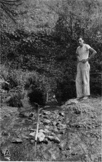
Table 6--Yields of four of the largest springs in Chase County.
| Name | Location | Flow, gallons per minute |
Aquifer |
|---|---|---|---|
| Palmer Spring | SW NE sec. 7, T. 18 S., R. 8 E. |
75* | Wreford limestone |
| Rock Spring | SE NE sec. 9, T. 21 S., R. 7 E. |
34** | Barneston limestone |
| Jack Spring† | SW NW sec. 25, T. 22 S., R. 7 E. |
95** | Barneston limestone |
| Perkins Spring† | Lot 6, sec. 19, T. 22 S., R. 8 E. |
70** | Wreford limestone |
| * Estimated flow Sept. 20, 1947. ** Measured by W. W. Wilson, Oct. 29, 1947. † Chemical analysis of water given in table 7. |
|||
Discharge by Wells
A third means of discharge of water from the ground-water reservoir is that by pumping or artesian flow from wells, which disposes of water not accounted for by the methods of discharge discussed in the preceding pages.
Public Water Supplies
Cottonwood Falls and Strong City are the only cities in Chase County having public water supplies; they are supplied from wells penetrating the alluvium of the Cottonwood River valley.
Cottonwood Falls--The water supply of Cottonwood Falls is obtained from several wells tapping the alluvium of the Cottonwood River valley northwest of the town (secs. 19 and 20, T. 19 S., R. 8 E.). The oldest wells, completed in 1923, known as Mercer Nos. 1, 2, 3, and 4, are combination dug and drilled wells about 30 feet deep and 30 feet apart. They are connected by laterals and pumped by one electrically powered pump. Three drilled wells 50 to 60 feet deep known as Rufner Nos. 1, 2, and 3 were added to the well field between 1925 and 1934 to augment the municipal water supply. In 1940 a 12-inch drilled well 47 feet deep, known as the Gates No. 1, was completed for use, and in 1948 a ninth well, Gates No. 2, was added to the well field (P1. 3).
Water is pumped from the well field to an elevated steel standpipe in the south part of town. The standpipe is 15 feet in diameter and 65 feet in height and has a capacity of 85,000 gallons.
A chemical analysis of the water is given in table 7. A cross section of the alluvium near this well field is shown in Figure 3.
Strong City--Strong City derives its water supply from one dug well, No. 19-8-2Oaa, 15 feet in diameter and 54 feet deep, completed in 1914 (P1. 3). The well penetrates 6 feet of coarse water-bearing sand and gravel in the lower part of the alluvium. Casing of brick and concrete rests on an iron shoe at the bottom, under and through which water enters the well.
Water is pumped from the well to the adjacent water plant by two 150-gallons-per-minute low-service turbine pumps. It is there treated for hardness. After treatment, the water is pumped by two 150-gallon-per-minute high-service pumps to an elevated 69,000-gallon covered concrete reservoir on a hilltop east of town.
A chemical analysis of the untreated water is given in table 7.
Industrial Supplies
There are no industrial users of ground water in Chase County. The Atchison, Topeka, and Santa Fe Railway Company and the Matfield pumping station of the Cities Service Gas Company utilize surface water for their operations.
Availability of Large Ground-water Supplies
In no part of the county can large supplies of ground water be developed, but moderate supplies such as are used by the cities of Cottonwood Falls and Strong City can be developed in the alluvium of the Cottonwood River, the lower portion of Diamond Creek, and the South Fork of the Cottonwood River.
Twenty-five test holes were drilled on five lines across the three principal stream valleys in the county in June 1948 with the hydraulic-rotary drilling machine owned by the State Geological Survey of Kansas. The location of the test holes is shown on Plate 3 and graphic cross sections along the five lines are shown in Figure 3.
Individual wells properly located so as to penetrate the maximum thickness of saturated alluvial material in the Cottonwood River valley should be capable of supplying 75 to 200 gallons a minute. The area of alluvium above the dam on Cottonwood River at Cottonwood Falls is probably the best area for wells of maximum yield. The dam creates a considerable body of water extending 2 to 3 miles upstream, thus maintaining a high water table and contributing effectively to the recharge of the ground-water reservoir in the area. Smaller quantities of water can be obtained from the other stream valleys in which the alluvium is not as extensive or thick.
The southwest part of the county is the only area in which wells penetrating stratified Permian rocks are capable of supplying moderately large quantities of water. Wells near the western edge of the county below the long dip slopes of the Barneston and Wreford limestones generally yield 5 to 10 gallons a minute and in some places yield 50 to 100 gallons a minute. Much ground water, which now is allowed to discharge through springs and seeps along the low areas where the formations crop out, could be utilized in this area.
Prev Page--Subsurface Rocks || Next Page--Chemical Character, Regions
Kansas Geological Survey, Chase County Geohydrology
Placed on web March 2001; originally published Aug. 1951.
Comments to webadmin@kgs.ku.edu
The URL for this page is http://www.kgs.ku.edu/General/Geology/Chase/pt3_resour.html