![]()
Prev Page--Mineral Resources || Next Page--Ground-water Resources
Subsurface Rocks
Stratigraphy and Structure
Conditions along an east-west line through the northern part of Chase County are shown in Figure 2. Major rock units are differentiated.
Figure 2--Geologic cross section showing conditions along an east-west line through the northern part of Chase County, differentiating major rock units. A larger Acrobat PDF version of this figure is available.
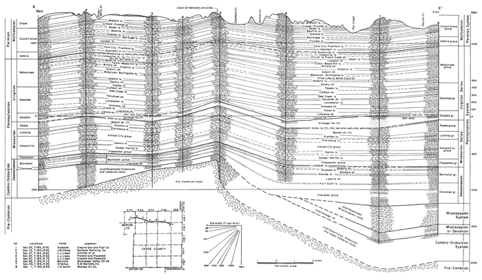
The Nemaha anticline, the buried crystalline core of which sometimes is called the granite ridge, is the dominant structural element in Chase County. Its axis extends in a north-northeast south-southwest direction through a point near Elmdale. Movement that formed this anticline, which extends entirely across Kansas and well into Nebraska and Oklahoma, occurred chiefly in early Pennsylvanian time. Erosion removed great thicknesses of rock from the anticline, and in Chase County as elsewhere along the fold, Pennsylvanian sediments overlap and overstep rocks ranging in age from Precambrian to Mississippian. Precambrian crystalline rocks lie next below middle Pennsylvanian rocks in the northern and southwestern parts of Chase County in higher parts of the anticline.
As indicated in Figure 2, rocks generally dip less steeply westward from the Nemaha anticline than eastward from the uplift, although locally the condition may be reversed. The part of Chase County east of the Nemaha anticline is regarded as being in the Forest City basin, and the western part of the county is on the west flank of the anticline or on the east flank of the Salina basin.
The stratigraphy of the major rock divisions encountered in the subsurface in Chase County is discussed in the following paragraphs.
Pennsylvanian Rocks
Pennsylvanian rocks in Chase County have an average thickness of about 2,000 feet. The Wabaunsee and Shawnee groups are characterized by shale and relatively thin limestone beds. The thickness of the Wabaunsee section is about 475 feet and of the Shawnee about 500 feet. The Oread limestone, the basal formation of the Shawnee group, is about 75 feet thick. The Douglas group consists almost entirely of clastic materials, but a persistent limestone occurs approximately 100 feet below the top. This is probably the Haskell limestone. The thicknesses of Douglas rocks differ from place to place, which indicates that 50 or more feet of Missourian rocks was eroded locally before deposition of Douglas sediments. Sandstone, ranging from about 200 to 250 feet in thickness, commonly occurs in the basal part of the Douglas section. In places where the Douglas rocks are relatively thin, 30 feet or more of rocks identified as belonging to the Pedee group is present. The combined Lansing and Kansas City groups comprise approximately 400 feet of nearly solid limestone. The Pleasanton shale is approximately 100 feet thick. Slightly more shale than limestone is present in the Marmaton section. About 350 feet of Cherokee shale is present in most of Chase County. The Cherokee is thin or absent in the Nemaha anticline area. Pennsylvanian beds lie upon Precambrian rocks in the vicinity of Elmdale.
Mississippian Rocks
Mississippian limestone formations and the Chattanooga shale have been removed by post-Mississippian erosion from the Nemaha anticline area in the northwestern part of Chase County (Lee, 1939, pl. 1; 1940; Jewett and Abernathy, 1945, pl. 3; Lee, Leatherock, and Botinelly, 1948, pl. 13; and Jewett, 1949, p. 115). The total thickness of Mississippian limestones in the county ranges from a featheredge to slightly more than 400 feet. The maximum thickness of the Chattanooga shale is about 150 feet.
Pre-Chattanooga Rocks
The "Hunton" limestone and the Maquoketa shale seemingly are absent from most of Chase County. The Viola limestone and other rocks as old as some part of the Arbuckle limestone have been eroded from most of the Nemaha anticline in the county (McClellan, 1930; Ockerman, 1935, fig. 2). Lee, Leatherock, and Botinelly (1948, pl. 13) show the pre-Chattanooga section in Chase County east of the Nemaha anticline as comprising (1) Kimmswick limestone, (2) Simpson formation, (3) Arbuckle dolomite, and (4) Lamotte sandstone. Bonneterre dolomite and Lamotte sandstone were found high on the upthrown side of the Nemaha fold in the Drummond well, sec. 15, T. 20 S., R. 7 E. Keroher and Kirby (1948, fig. 3) did not recognize Lamotte sandstone in Chase County but show Roubidoux dolomite occurring next above the Precambrian surface except in the northeast part of the county where Bonneterre dolomite is shown as being in contact with the basement rocks. According to Keroher and Kirby (1948, figs. 4, 8, and 9), the Jefferson City-Cotter section ranges from about 125 to 400 feet in thickness in the county, the Roubidoux dolomite ranges from slightly less than 100 to more than 150 feet in thickness, and the Bonneterre dolomite is present only in the northeastern part of the county, where its maximum thickness is less than 50 feet.
Oil and Gas
Exploration and Production
Oil and gas have been found sparsely distributed over Chase County. The county as a whole has been inadequately explored. Oil has been found only in the southeastern corner in extensions of pools from Greenwood and Lyon counties. Gas has been discovered at several places within the county, but mostly on the Nemaha anticline. Previously, more gas was produced than was used within the county, and it was piped to towns in Morris and Lyon counties. Now, however, it is used only locally. According to available records, 356 holes have been drilled in Chase County for oil and gas. Of this total, 37 have produced oil and 142 have produced gas in the past, or are producing at present.
Producing formations--The rocks in which gas has been found include the Ireland sandstone in the Lawrence shale and the Langdon shale, both of Late Pennsylvanian age. Gas also is produced from the Indian Cave sandstone member of the Towle shale, the West Branch shale, and the Hamlin shale, all of Early Permian age. Oil is produced from the "Bartlesville sand" in the Cherokee shale of Middle Pennsylvanian age.
Although 117 holes have been drilled into rocks of Mississippian age and older, no oil or gas has yet been found in rocks older than Pennsylvanian in age. Survey files contain records of 24 holes drilled into the Precambrian granite. Locations of oil and gas wells and dry holes and their stratigraphic depths are shown on Plate 2.
Drilling activity in recent years--In 1948 four wells were reported drilled in the county. One dry wildcat, the K. T. Anderson et al. No. 1 Diggs well in the 5E SE NE sec. 13, T. 18 S., R. 9 E. was completed in June 1948 and abandoned in the Arbuckle dolomite at 3,340 feet. Two dry wells were drilled in sec. 13, T. 18 S., R. 9 E. near the Pixlee field in Greenwood County. One dry hole was drilled in the Chase County part of the Atyeo field.
In 1949 ten wells were reported for oil and gas. Six of these holes were stratigraphic test holes drilled by the Amerada Petroleum Corporation. All six were reported as dry and abandoned. A dry wildcat, the Aladdin Petroleum Company No. 1 Altemus in the SE SE NE sec. 26, T. 18 S., R. 8 E., was completed in July 1949 and abandoned in the Arbuckle at 3,252 feet. Another dry wildcat was the Alyward and Seibel No. 1 Hindren well in the S/2 SW SW sec. 15, T. 21 S., R. 6 E. completed in November 1949 and abandoned in Ordovician rocks at 3,497 feet. One dry well was drilled in Mississippian rocks in the Atyeo field. One dry shallow well was drilled in the Davis gas field in 1949.
Six dry holes were drilled in Chase County in 1950. One of these wells was drilled into Mississippian rocks to a depth of 2,570 feet in the Atyeo field. Mississippian rocks also were reached in a well in sec. 14, T. 20 S., R. 9 E. The four remaining wells drilled in 1950 were drilled to the Arbuckle dolomite. Two of these wells are in the northwestern part of the county in sec. 29, T. 18 S., R. 6 E., and in sec. 7, T. 19 S., R. 6 E. The remaining Arbuckle wells were drilled in the eastern part of the county in sec. 21, T. 21 S., R. 8 E., and in sec. 22, T. 18 S., R. 9 E.
Gas Fields
Altemus field--The Altemus gas field, sec. 26, T. 18 S., R. 8 E., has one producing well, but no log is available. The well is located through oral communication with the inhabitants of the farm on which it is situated. The gas produced is for local farm use only.
Davis field--The Davis gas field, in secs. 19, 29, and 30, T. 18 S., R. 8 E., is by far the largest gas-producing area in the county today. The first producing gas well was drilled in 1929, with an initial production of 681,000 cubic feet. Most of the wells were drilled from 1940 to 1944, however. The field was discovered by the drilling of a well in sec. 19, T. 18 S., R. 8 E. which had an initial production of a few barrels of oil a day. This well was abandoned shortly after it was drilled but upon further extensive drilling for the same oil zone, abundant quantities of gas were found in the Indian Cave sandstone and a sand in the Hamlin shale, both of Early Permian age, at depths that ranged from 260 to 439 feet. The initial volume of gas in each well ranged from 50 to 1,000 thousand cubic feet per day. Three of the 36 drilled in this field have been dry. Three wells are abandoned gas wells, one is an abandoned oil well, and the remaining 29 wells are still producing gas today. The gas from this field is piped approximately 5 miles south into Strong City for use in that town. Part of the gas is piped a mile farther south into Cottonwood Falls for local use in that town. During the winter months the production is not high enough to supply the total needs of the two towns and as a result the supply must be supplemented by gas from the Cities Service pipe lines.
The Davis gas field is the only field in the county on which open flow figures are recorded. In 1948 a total of 42,845,000 cubic feet of gas was produced and in 1949, 49,276,000 cubic feet was produced.
Elk field--The Elk gas field is in secs. 15, 20, 21, 22, 27, and 28, T. 19 S., R. 6 E. The earliest producing well of which the Survey has a record was drilled in January 1930 with an initial production of 786,000 cubic feet of gas per day. Two more wells were drilled in June of the following year, and the other producing wells were drilled in a period extending from 1933 to 1939. The producing formation in this field is a sandy zone in the Hamlin shale (Admire group) of Early Permian age at an average depth of 500 feet. The only dry hole of 18 holes drilled in this field extended to Precambrian granite. Nine wells have produced gas in the past but are now abandoned. Eight of the wells have gas in them today but are capped and not in production. As a result there is no production at the present time from the Elk field. Gas from this field was formerly piped to Florence, approximately 15 miles to the southwest in Marion County. This was abandoned in 1945, however.
Elmdale field--The Elmdale gas field, in secs. 20, 26, 27, 28, 33, 34, 35, and 36, T. 19 S., R. 7 E. and in secs. 1, 2, and 3, T. 20 S., R. 7 E., has only five producing wells today. The field is said to have been discovered in the early 1920's but the year is uncertain. Forty-one wells produced gas in the past but are now abandoned. Six wells drilled in the field have been dry. None of these dry holes was drilled to the Precambrian granite at depths ranging from 1,805 to 2,810 feet. The Survey has no record of any of the producing or abandoned gas wells. They were located through the aid of Mr. W. F. Kline of Elmdale, and according to him two of the producing wells are approximately 500 feet deep and two are approximately 800 feet deep. The producing formations in this case would probably lie within the Wabaunsee group of Late Pennsylvanian age. No open flow measurement is kept on these wells but the gas is piped into Elmdale for use within that town. Their supply is supplemented by three producing wells in the Lipps field to the north. These three wells together with the five wells in the Elmdale field produced an estimated total of 10,500,000 cubic feet of gas in 1949.
Hymer field--The Hymer gas field, secs. 17 and 18, T. 18 S., R. 7 E., has only two producing wells, neither of which the Survey has any record, but which were located through oral communication with the inhabitants of Hymer. Both wells are used for local farm use only.
Lipps field--The Lipps gas field is located in secs. 25 and 36, T. 18 S., R. 6 E. and in secs. 29, 30, 31, and 32, T. 18 S., R. 7 E. The discovery well was drilled in September 1925 in sec. 32, T. 18 S., R. 7 E. The other wells were drilled in 1926 and 1927. The initial daily production ranged from 2,000 to 4,261,840 cubic feet of gas. The producing formation is the Ireland sandstone member of the Lawrence shale of Pennsylvanian age at an average depth of 1,200 feet. Two of the 37 holes drilled in the field penetrated the Precambrian granite. Of the 37 holes drilled, 11 were dry, 19 have produced gas in the past but are now abandoned, and six wells are producing gas today. The Cities Service Gas Company formerly piped the gas produced from this field to Emporia for use in that city. Now, however, gas from three of the producing wells is piped into Elmdale and the gas from the three remaining producing wells is for local farm use.
Neva field--The Neva gas field, secs. 14 and 15, T. 19 S., R. 7 E., has only one producing well today. There are three other wells which formerly produced gas but are now abandoned. The Survey has no record of any of these wells, and they were located through the courtesy of Mr. W. F. Kline of Elmdale. The gas from the producing well is piped into Elmdale via the pipe line that connects the Lipps field with Elmdale.
Strong City field--The Strong City gas field, in secs. 13 and 24, T. 19 S., R. 7 E. and sec. 19, T. 19 S., R. 8 E., formerly produced gas from the Langdon shale of Pennsylvanian age as well as the West Branch shale and the Hamlin shale of Early Permian age. The largest producer was the Langdon shale at an average depth of 450 feet. The first well was drilled in 1925, but no initial production figures are available. The other wells were drilled in a period extending from 1937 to 1940. Of the 19 wells drilled in this field, seven were dry and 12 have produced gas in the past but are now abandoned. Two of the dry holes are stratigraphic test holes drilled in 1949 by the Amerada Petroleum Corporation.
Oil Fields
Atyeo field--The Atyeo field, mainly in Lyon and Greenwood counties, has a westward extension into Chase County in secs. 24, 25, and 36, T. 21 S., R. 9 E., and in sec. 1, T. 22 S., R. 9 E. The producing formation is the "Bartlesville shoe string sand" at an average depth of 2,250 feet. The daily initial production was from 15 to 60 barrels per well. Discovery was made in 1926. Of 13 holes drilled in the field, eight were dry and five produced oil; only two wells now produce in the Chase County portion of the Atyeo field. In 1948 these two wells produced a total of 1,666 barrels of oil. In 1949 their total production was 5,780 barrels of oil. The production in 1950 was 9,283 barrels of oil.
Teeter field--The Teeter oil field, in the southeastern corner of Chase County in secs. 25, 35, and 36, T. 22 S., R. 9 E., is the most important oil-producing area of the county. It is a northward extension of the major part of the field in Greenwood County. Discovery was made in 1925. The producing formation is the "Bartlesville shoe string sand" at an average depth of 2,500 feet. Initial daily production ranged from 6 to 515 barrels per well, the average being about 100 barrels. Of 48 holes drilled in the pool, 17 were dry and 31 have produced oil, 21 of which are still producing oil. In 1948 the total production of the Chase County part of the Teeter field was 18,551 barrels, in 1949 it was 31,138 barrels, and in 1950 it was 28,311 barrels.
Prev Page--Mineral Resources || Next Page--Ground-water Resources
Kansas Geological Survey, Chase County Geohydrology
Placed on web March 2001; originally published Aug. 1951.
Comments to webadmin@kgs.ku.edu
The URL for this page is http://www.kgs.ku.edu/General/Geology/Chase/pt2_subs.html