![]()
Prev Page--Table of Contents || Next Page--Mineral Resources
Part 1--Rock Formations of Chase County
by Raymond C. Moore, John Mark Jewett, and Howard G. O'Connor
Introduction
This is the first of a series of reports on the stratigraphy, economic geology, and ground-water resources of eastern Kansas counties, consisting primarily of maps (Pls. 1, 2, and 3), but containing brief descriptive stratigraphy and discussions of ground water and other useful materials.
Location and Geography
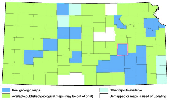
The location of Chase County in Kansas is shown in Figure 1. The county lies in the approximate center of the eastern half of the state, including Ts. 18, 19, 20, 21, and 22 S., Rs. 6, 7, 8, and 9 E. and the eastern tier of sections in Ts. 20, 21, and 22 S., R. 5 E., comprising approximately 774 square miles.
Figure 1.--Index map of Kansas showing area described in this report and areas covered by other geologic maps, as of Feb. 2001. For additional information, the KGS Geologic Maps of Kansas Page.
The population of Chase County is 5,020 (1950 census). The population of Cottonwood Falls, county seat, is 1,047, and of Strong City 724. Cattle raising is the principal industry; about 70 percent of the area is unplowed grassland.
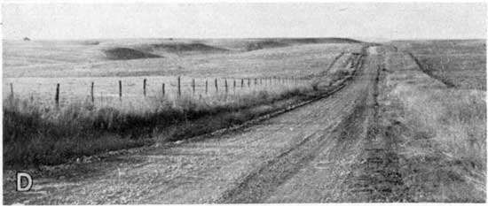
Land surfaces in Chase County range from approximately 1,100 feet to 1,500 feet above sea level. The main topographic form is the Flint Hills escarpment and upland (Moore, 1930; Jewett, 1941, pp. 17-21; Schoewe, 1949, pp. 286-289), which is dissected by Cottonwood River and some of its tributary streams.
Field Work
Most of the field work on which this report is based was done in the summer of 1947 by Moore, Jewett, and O'Connor, who were assisted by James M. Parks and Edward J. Zeller. Ground-water investigations were made by O'Connor working more or less independently. Test drilling in alluvial deposits was done in the summer of 1948 under the supervision of O'Connor. Areal geology was mapped on air photographs (scale 1: 20,000). Rock sections were measured in detail, using a rule, Locke level with stadia, and telescopic level with a 12-foot rod.
Previous Geologic Work
Most of Chase County is included in the Cottonwood Falls quadrangle (between 38° and 38°30' north latitude and 96°30' and 97° west longitude) the geology and topography of which were described by Prosser and Beede (1904). Rocks cropping out in the Flint Hills in Chase and other counties have been studied by several geologists and have been described in several publications (Moore, 1918; Fath, 1921; Bass, 1929; Condra and Upp, 1931; Jewett, 1941). Because of the interest aroused several years ago when Precambrian rocks were found at comparatively shallow depths in the Nemaha anticline, the subsurface geology of Chase County has been described rather widely (McClellan, 1930; Lee and others, 1946).
The geology of Chase County pertaining to oil and gas has been discussed by Jewett and Abernathy (1945), and by Jewett (1949); mineral resources were described briefly by Landes (1937, pp. 13-14).
Acknowledgments
Many citizens of Chase County were extremely helpful while field work was in progress. Their cooperation is greatly appreciated. Special thanks are expressed to several people who furnished information of various kinds. Among these are Willard Hilton, State Board of Health; N. D. Jackson, The Texas Company; Walter F. Kline, Elmdale Gas Company; William Wlivowsky, Strong City Gas Company; Earl J. Coulter, Cities Service Gas Company; and Hazen Bledsoe, driller. Plates 1, 2, and 3 were drafted by Alice White and W. W. Wilson.
Stratigraphy of Outcropping Rocks
Plate 1 is an areal geologic map of Chase County. With the exception of stream valley alluvium and terrace deposits, which are of Pleistocene and Late Tertiary (?) age, all exposed rocks in Chase County belong to the Permian System (Pl. 1). Most are of early Permian (Wolfcampian) age. In pages devoted to descriptions of the rock succession of Chase County, statement of thicknesses and distribution applies to this county only, unless otherwise indicated.
Quaternary System
Pleistocene Series
Stream-Valley Alluvium
Stream-laid deposits of gravel, sand, silt, and clay as much as 55 or 60 feet in thickness occupy the valleys of Cottonwood River, South Fork of Cottonwood River, and Diamond Creek. Thinner accumulations, which are more variable in lithology, partly fill the valleys of smaller streams. In the valleys of the larger streams, coarser material, in deposits generally from about 3 to 18 feet thick, commonly is found in the lower parts of the accumulations.
Gravel and sand in these deposits contain fragments of limestone and mollusk shells rather freely intermingled with quartz and chert. The finer material, which occurs more commonly in the upper part of the alluvial accumulations, consists of silt and clay, generally sandy in the lower parts but commonly nearly free of sand in the upper parts. Colors, in general, are darker near the present land surface while variations of tan, buff, reddish buff, brown, gray, and gray green are seen in samples taken from bore holes. The lower parts of the deposits of finer materials generally are calcareous.
The extent of stream-valley alluvium, except very narrow belts in small valleys, is shown on Plate 1.
Terrace Deposits
Stream-laid deposits of gravel, sand, silt, and clay and possibly volcanic ash occur in terraces at elevations lower than those of Tertiary (?) terraces. On the areal geologic map (Pl. 1) Pleistocene and probable Tertiary deposits that occur in terraces are undifferentiated.
The most prominent and extensive Pleistocene terrace occurs along the valleys of Cottonwood River and South Fork Cottonwood River. This terrace is here called the Emporia terrace because of its prominent development in the vicinity of Emporia, a few miles east of Chase County. The basal accumulations of the Emporia terrace lie on Permian rocks, generally 10 to 20 feet higher than the present alluvial floodplain surface. Seemingly, however, where in contact with shale beds, the terrace deposits lie on an eroded surface almost as low as the present floodplain.
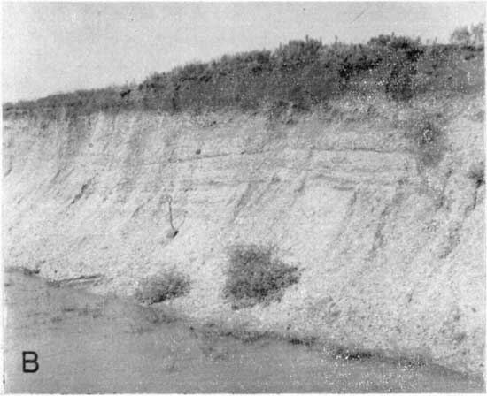
Material in the lower part of the Emporia terrace is well exposed in a gravel pit in the NE SW sec. 10, T. 19 S., R. 9 E. (Pl. 4A, 4B). It consists chiefly of coarse subrounded to subangular chert gravel, one-quarter to 3 inches in diameter. There is an intermingling of chert and quartz sand and a minor amount of silt and clay. The sorting is poor. This predominantly coarse material, which ranges in thickness from a few inches to about 15 feet, grades upward into tan and buff sandy silt, overlain by tan, buff, or reddish-brown silt and clay. The thickness of the finer material above the gravel ranges from a few inches to about 20 feet. Locally, various amounts of silt and clay have been removed and, except in the thicker deposits, calcareous matter has been leached.
Plate 4A--Quarry in Pleistocene terrace gravel along Cottonwood River Valley, NE SW sec. 10., T. 19 S., R. 9 E. (Photo by H.G. O'Connor)
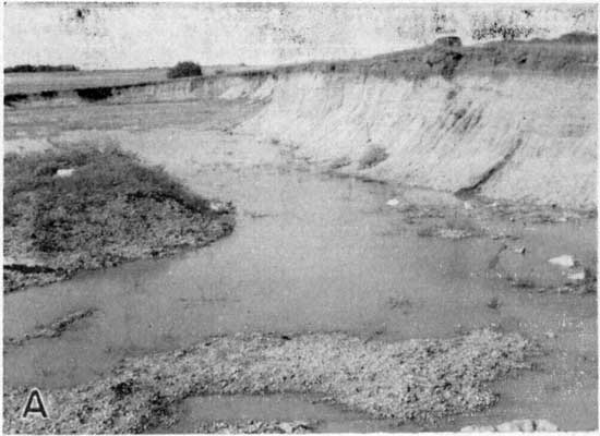
Plate 4B--Close-up of quarry face shown in A. (Photo by H.G. O'Connor)
Vertebrate remains, thought to be mid-Pleistocene in age, have been found in the Emporia terrace in Lyon County, and Pearlette volcanic ash has been reported above the basal sand and gravel and below about 40 feet of silt and clay in the terrace at Emporia (Frye, Swineford, and Leonard, 1948, pp. 508-510).
Tertiary System (?)
Pliocene Series (?)
Terrace Deposits
East of the Flint Hills in Chase County, belts of terraces border the major stream valleys at elevations ranging from 50 to 150 or more feet above the present floodplains. The materials comprising these high terraces were derived chiefly from cherty Lower Permian limestones that are exposed in the Flint Hills, and seemingly to a lesser extent from sandy beds in the Kiowa shale (Gulfian) somewhat farther west. The deposits consist chiefly of chert fragments, one-quarter to about 3 inches in diameter, with some smaller ones. Also there are sand grains of colorless quartz, mostly well rounded. Noncalcareous reddish clay occurs with the sand and gravel in amounts sufficient to bind it firmly together. The thickness of these alluvial accumulations ranges from a few inches to about 16 feet.
Topographic position of the high terrace deposits in Cottonwood River valley, compared with that of similar gravel deposits which occur below Kansan or earlier glacial till in Kansas River valley, suggests equivalent age. Furthermore, these deposits are higher, thinner, and more thoroughly dissected than those of the Emporia terrace, which is judged to be late Kansan in age. Although not studied in detail, high-terrace chert gravels occur throughout most of eastern Kansas and have been described briefly in many geologic reports (Wooster, 1915; Todd, 1918, 1918a; Bass, 1929, pp. 104-108; Jewett, 1941, p. 19; 1945, p. 13; Moore and others, 1951, p. 20.).
Permian System
Leonardian Series
Sumner Group
Wellington Shale
A maximum of 40 to 50 feet of sediments, classified as the lower part of the Wellington shale, occurs in a small area in southwestern Chase County. Outcrops are not suitable for a measured section. In that area, about 2 feet of impure limestone was observed 40 feet above the base of the Wellington formation, and this limestone (mapped as the Hollenberg limestone by Moore and Landes, 1937) is the youngest Permian rock in the county. Gray, green, and red gypsiferous shale occurs between the Hollenberg (?) limestone and the underlying Herington limestone. The areal distribution of the Wellington formation is shown on Plate 1. It is not a source of ground water in this area.
Wolfcampian Series
Chase Group
Nolans Limestone
The Nolans limestone, comprising two limestone members and a shale member, ranges in thickness from about 22 to 26 feet. Except possibly in the small area where overlain by Wellington shale this formation does not yield water to wells.
Herington limestone member.--Although parts of the Herington limestone are nonresistant, it contains some resistant beds that hold a prominent bench above the softer beds below. The upper and lower parts are more massive and more resistant than the middle part. The rock is largely dolomite.
The upper and lower parts of the Herington limestone are light-gray to buff hard sucroselike to dense dolomitic limestone, commonly containing sparse impure gray chert nodules and cauliflowerlike geodes. The middle part is light-brown to buff thin-bedded sucroselike dolomitic limestone. This part in weathered exposures is porous because of the leaching of abundant small gastropods and pelecypods.
Geodes of coarse-grained chalcedony or finely crystalline quartz or less commonly calcite, ranging from about an inch to about 10 inches in diameter, are scattered throughout the Herington limestone. The thickness of the member ranges from about 10 to 15 feet.
Paddock shale member.--The thickness of the Paddock shale ranges from about 6 to 9 feet. It is olive-gray and light drab-gray shale containing more or less calcareous zones in its middle part. Cauliflowerlike geodes of drusy or finely crystalline quartz and calcite occur plentifully in the upper part. The geodes range in diameter from about an inch to 10 inches. Some of them are at the top of the Paddock shale, partly embedded in the overlying limestone. Pelecypods, especially Aviculopecten, are locally abundant.
Krider limestone member.--The Krider member in Chase County is a dolomitic limestone which ranges in thickness from 2 to 4 1/2 feet. Commonly the lower part comprises less than a foot of yellow to greenish-gray impure dolomitic limestone. This is overlain by gray-green shale, one-half to 2 feet thick. The upper part is gray to tan fossiliferous limestone, 1 1/2 to 3 feet thick.
Odell Shale
The Odell shale ranges in thickness from 20 to 30 feet. The upper 3 to 8 feet is gray to gray-green and the middle and lower parts show shades of red, purple, and green. Locally, the lowermost few feet is gray and calcareous. Thin discontinuous to nodular impure limestone beds occur commonly in the upper and middle parts. Little or no ground water is obtained from the Odell shale.
Winfield Limestone
The Winfield limestone, comprising two limestone members and a shale member, ranges in thickness from about 20 to 24 feet. Small supplies of ground water are obtained from this limestone, principally from the Cresswell member, in a limited area.
Cresswell limestone member.--Light-gray to yellowish-gray mostly massive limestone comprises the largest part of the Cresswell limestone. As seen in some exposures, the upper part consists of yellowish-gray limestone-bearing siliceous geodes and overlying limy shale or shaly limestone. The lower one-half to two-thirds of the member, however, is thick-bedded or locally somewhat slabby with thin shale partings. Chert is rather common. Purer chert occurs in small nodules with rudely concentric color bands that are darker in the central part. Less pure chert is brown or reddish and occurs in larger nodules, many of which are discoidal in shape. The thickness of the member ranges from about 9 1/2 to 14 1/2 feet.
Grant shale member.--The Grant shale ranges in thickness from 3 to 9 feet. The upper part comprises light-gray to yellowish-gray shaly limestone that weathers as shale, and the lower part gray calcareous shale. Locally, calcite geodes occur in the lower part. Fossils are sparse in most outcrops.
Stovall limestone member.--The Stovall limestone, lower subdivision of the Winfield formation, ranges from 1 to slightly more than 4 feet in thickness along its outcrop. Dark-gray chert nodules are present in some exposures, but are absent at others. The limestone is light gray but weathers yellowish to slightly rusty. At fresh exposures, the boundaries are sharply defined from overlying and underlying shale.
Doyle Shale
The thickness of the Doyle shale is everywhere about 62 feet. With soft limestone beds in the upper part of the Fort Riley limestone, it lies below long gentle slopes broken by a bench held by the Towanda limestone member. Lower beds of the Doyle are important sources of ground water in a considerable part of southwestern Chase County. Well water is obtained from these rocks at depths ranging from a few feet to more than 100 feet.
Gage shale member.--The upper part of the Gage shale consists primarily of yellow and gray calcareous shale bearing crinoid fragments, brachiopods, and pelecypods in one or more zones and locally coquinas of Derbyia. One to 4 feet of gray platy or splintery limestone occurs below the fossil zones. The lower and middle parts consist almost entirely of red, purple, and green shale with a minor amount of impure limestone in thin beds. The thickness of the member ranges from about 38 to 44 feet.
Towanda limestone member.--This member comprises 8 to 10 feet of gray hard platy limestone which weathers yellow to tan and locally contains brecciated zones. Thin shale breaks are common in the upper part.
Holmesville shale member.--These beds consist of unfossiliferous green and (less commonly) gray shale with thin beds of impure limestone and impure gypsum. Green shale is characteristic of the upper and lowermost parts. An easily recognized zone, consisting of 1 to 2 1/2 feet of crystalline calcite "chains" 3 mm in diameter in clayey matrix, occurs in the upper part. At long-weathered exposures the clay has been removed leaving porous boxworks of these tiny crystalline chains. The thickness of the Holmesville shale is about 8 to 12 feet.
Barneston Limestone
The Barneston limestone is about 80 feet thick. This limestone is the most important bedrock aquifer in this area and wherever it occurs extensively as it does in southwestern Chase County, it supplies water of good quality in quantities of 100 gallons a minute or more.
Fort Riley limestone member.--The upper beds of the Fort Riley limestone are massive but soft; in only a few places they form a distinct but not prominent topographic bench. They are light gray to light tan, and are chalky and platy. Fossils are sparse or absent. The middle limestone beds also are gray to light tan, platy, and chalky. Crinoid fragments, mollusks, and brachiopods are more or less plentiful. The lower part consists of massive beds of gray to buff porous fossiliferous limestone. This "rimrock" part, except in a few places, does not form a wall-like outcrop, as it does farther north in Kansas. Fossils in the lower part include abundant to sparse pelletlike algae, fusulines, echinoderm fragments, brachiopods, and mollusks. The thickness of the member commonly is about 40 feet.
Oketo shale member.--Gray to buff calcareous shale, containing echinoid and crinoid fragments, brachiopods (Derbyia, Wellerella, Dictyoclostus, Composita), and sparse gastropods, characterizes the Oketo shale. The member is everywhere thin or absent; locally it cannot be differentiated. The maximum thickness is about 3 feet.
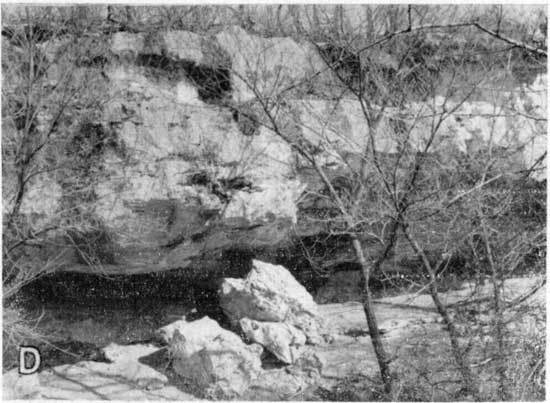
Florence limestone member.--The Florence is a hard light-gray to yellowish-gray fossiliferous limestone containing abundant blue-gray chert nodules and beds (Pls. 4C, 5D). Almost everywhere it makes a well-defined bench in the topography. Commonly, two or more thin fossiliferous shale breaks occur in the lower part. The middle part is sparsely cherty limestone, which in many places is cellular and porous. Fossils include fusulines, bryozoans, corals, brachiopods, and mollusks. The thickness of the member is about 39 feet.
Plate 4C--Chert nodules in lower part of Florence limestone, southern Chase County. (Photo by H.G. O'Connor)
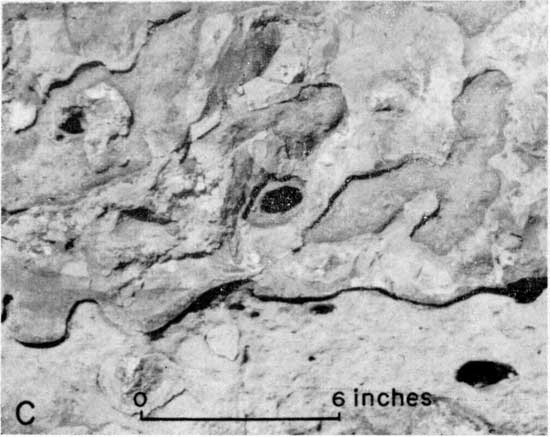
Plate 5D--Characteristic strong rounded bench formed by the Florence limestone, SE sec. 2, T. 21 S., R. 6 E. (Photo by H.G. O'Connor)
Matfield Shale
The three members of the Matfield shale are of about equal average thickness; the total amounts to about 57 feet. The formation generally yields little or no water to wells except for small supplies sometimes obtained from the middle member.
Blue Springs shale member.--The thickness of the Blue Springs shale is about 15 to 20 feet. It is divisible into persistent zones. Slightly less than the upper half of the member comprises gray, yellow, or olive shale containing thin discontinuous beds of limestone with sparse pelecypods. Below this zone and slightly above the middle, a 1-foot bed of molluscan limestone occurs. Olive and green shale comprise the middle and lower parts of the Blue Springs shale, and bright red, purple, and (less commonly) green shale constitutes a basal zone ranging from a few inches to about 6 feet in thickness.
Kinney limestone member.--The thickness of the Kinney limestone ranges from about 15 to 22 feet. Three major zones are persistent. They show marked variations in thickness and lithology, however.
The upper zone consists of limestone beds 2 to 6 feet thick. This unit commonly makes a prominent bench which is bordered by large rhomboidal blocks of limestone. Within distances as short as 100 yards, however, it may change from a single massive bed to several thin beds separated by shale partings; these thin limestones are inconspicuous and nonresistant to weathering. Thickness changes are abrupt. Ostracodes are characteristic of this rock and in some places they comprise almost the entire bed. Locally, the matrix material has been leached so as to produce a soft friable rock resembling sandstone; the "grains" are chiefly ostracode tests. Echinoderm fragments, brachiopods, and mollusks are rather plentiful in facies which lack numerous ostracodes.
Shale beds in the middle part of the Kinney limestone are gray, buff, and green. Most exposures include one or more calcareous zones or thin limestone beds. Fossils, including bryozoans, echinoid and crinoid fragments, Derbyia, Composita, and other brachiopods, are abundant, especially in the middle and lower parts.
The lower part, 2 to 7 feet thick, is occupied by one or more limestones, ranging from shaly beds to resistant hard rock that forms a prominent topographic bench. Echinoderm fragments, Derbyia, Composita, productids, and pelecypods are the common fossils in this part of the Kinney limestone.
Wymore shale member.--The thickness of the Wymore shale ranges from about 15 to 23 feet. The upper part comprises gray and yellow shale with thin discontinuous limestone beds. The middle part consists of red, purple, and green shale which contains a lenticular impure limestone "boxwork" (secondary fillings along joints and bedding). Gray, yellow, and olive shale occurs generally in the lower part of the member.
Wreford Limestone
The Wreford limestone, including two limestone members and a shale member, has an average thickness of about 35 feet in Chase County.
Wherever this formation occurs beneath the surface at depths less than about 150 feet and is not intricately dissected, good supplies of ground water generally may be obtained from it.
Schroyer limestone member.--The thickness of the Schroyer limestone ranges from about 8 to 13 feet. The upper 3 or 4 feet is light gray and finely porous. It is more resistant to weathering than the remainder, which is similar in lithology except for abundance of chert nodules. Brachiopods are the most common fossils in this member; echinoderm fragments and bryozoans are less abundant. The Schroyer limestone does not produce a strong topographic bench, but with underlying shale beds, commonly lies below a gentle slope of considerable width.
Havensville shale member.-The average thickness of the Havensville shale is about 10 feet. It comprises gray, buff, and olive shale interbedded with thin lenticular beds of limestone. Echinoderm fragments, bryozoans, brachiopods, and pelecypods are abundant.
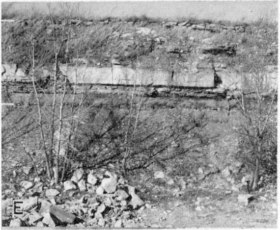
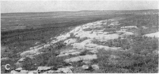
Threemile limestone member.--Measured sections of the Threemile limestone range from 14 to 23 feet. An easily differentiated upper zone comprises gray, more or less porous chalky limestone with abundant chert. The chert is arranged in bands or in some places is scattered; it is more abundant in the upper and lower parts, and locally chert is absent in the middle part. The sparsely cherty middle part forms a strong prominent bench over most of its line of outcrop (Pls. 4D, 6C). A zone of gray. fossiliferous shale, commonly 1 to 2 feet thick, but locally much thinner or absent, separates the two limestone zones of this member. The basal part of the member is a blocky gray limestone generally containing two bands of chert. The thickness of this part ranges from 1 to 4 feet. Brachiopods are the most abundant fossils in the Threemile limestone, but sparse fusulines, bryozoans, echinoderm fragments, and a few mollusks also are present.
Plate 4D--Massive sparsely cherty outcrop of Threemile limestone showing large solution caves in lower part; along creek in Lot 10, sec. 19, T. 22 S., R. 8 E. (Photo by H.G. O'Connor)
Council Grove Group
Speiser Shale
The thickness of the Speiser shale is commonly about 18 feet, but it ranges from about 13 to 20 feet. The upper 1 to 6 feet in all exposures studied consists of gray calcareous abundantly fossiliferous shale with a thin limestone locally at its base. Bryozoans, echinoderm fragments, and brachiopods--especially Chonetes, Composita, and Derbyia--occur in this zone. The middle and most of the lower part of the Speiser shale comprise unfossiliferous red and purple shale and lesser amounts of green shale. The Speiser shale is unimportant as a source of ground water.
Funston Limestone
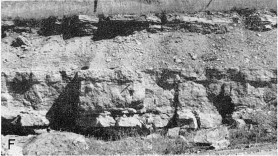
The Funston limestone is characteristically about 17 feet thick, but ranges from 13 to 25 feet (Pl. 4E). It comprises an upper and lower limestone, separated by shale. The upper limestone is gray when newly exposed to weathering but in time it becomes buff or brown. Its upper part is decidedly platy and the lower part massive. In many places it bears chert nodules or quartz-lined geodes.
Plate 4E--Funston limestone, complete excepth for a small part of the upper limestone bed; exposed in face of quarry. Thin basal limestone is algal. SE NW sec. 3, T. 20 S., R. 6 E. (Photo by H.G. O'Connor)
The shale between the two limestones is gray, gray-black, or green and silty in the upper part, and commonly a thin limestone bed occurs in the middle or lower part. Locally, it contains thin lenses or stringers of porous chert near the top. The lower part of the shale is gray to black and at some exposures bears bryozoans, brachiopods, and mollusks; in places it is nearly barren of fossils. At an exposure near the Cen. sec. 1, T. 21 S., R. 7 E., the lower part of the shale is represented by slabby limestone consisting almost entirely of bryozoans. At the same place, the middle part is gypsiferous and the upper middle part contains stringers of chert.
Both the upper and lower limestone beds of the Funston formation are composed largely of mollusks. Calcareous algae occur, at least locally, in all parts of the formation, although most commonly in the lower part.
A few shallow wells obtain small supplies of ground water from the Funston limestone. However, wells in this formation are generally of low yield, variable in quality, and not dependable.
Blue Rapids Shale
The average thickness of the Blue Rapids shale is 15 to 17 feet; locally it is much thinner. Gray, green, and red shale comprises almost the entire formation, although there are some thin limestone beds and zones of limestone nodules and calcareous "boxwork" (secondary filling along bedding and joint planes). It supplies little or no water to wells in this area.
Crouse Limestone
The Crouse limestone comprises an upper and lower limestone separated by shale. The combined thickness commonly is about 16 feet.
The upper Crouse limestone is divisible into two lithologic units. The uppermost part, about 1 to 3 feet thick, is conspicuous because of its very platy structure. It is light to dark gray or buff. In some places this part has the appearance of platy calcareous shale. Gray or buff massive limestone, which forms a prominent topographic bench and furnishes large detached blocks of rock along its outcrop, comprises the lower part of the upper Crouse limestone (Pl. 5B). This part ranges in thickness from about 1 1/2 to 3 feet. Locally it contains siliceous nodules or geodes and is characterized by rusty-weathering, small high-spired gastropods, and small clams. "Osagia"-type algae are abundant in some parts of the upper Crouse limestone.
Plate 5B--Lower part of the upper limestone bed, the "quarry rock" of the Crouse. (Photo by H.G. O'Connor)
The shale of the Crouse limestone also is divisible into two distinct lithologic units. The upper part, 5 to 10 feet thick, is gray or buff unfossiliferous clay shale. The lower part, ranging from about 1 to 5 feet in thickness, is gray and abundantly fossiliferous, containing microfossils, byrozoans, echinoderm fragments, and brachiopods.
The lower part of the Crouse is a gray or buff mottled silty limestone which has a rather slabby structure. Commonly it is a molluscan limestone, but locally it contains a varied assemblage of mollusks, bryozoans, and brachiopods. The thickness range is between about 0.8 and 2.5 feet.
A few shallow wells obtain small supplies of ground water from the Crouse limestone. Deeper wells penetrating this limestone generally obtain little or no water from this zone.
Easly Creek Shale
Measured sections of the Easly Creek shale range from 12 to 18 feet in thickness. Predominantly the formation comprises green clayey and calcareous shale, with two zones of bright red or purple material occurring near the middle or in the lower part. A zone of nodular limy material or "boxwork" occurs in some outcrops near the base. It supplies little or no ground water to wells in Chase County.
Bader Limestone
The average thickness of the Bader limestone is about 28 feet. Locally this formation, principally the lower member, is a source of small supplies of ground water for domestic and stock wells.
Middleburg limestone member.--The upper Middleburg limestone member of the Bader formation is divisible into four lithologic units. The total thickness commonly is about 7 feet. At the top is 1 to 2 feet of light-gray platy to slabby limestone commonly containing small high-spired gastropods. This uppermost limestone unit is underlain by 1 to 2 feet of black or dark-gray platy shale. Next below is a zone of dark-gray slabby limestone or calcareous shale, about 0.5 to 2 feet thick. The lowermost unit is light-gray massive to slabby or nodular limestone, 1 to 3 feet thick. It commonly contains small snails and clams; locally, however, it bears crinoid fragments, bryozoans, and productid brachiopods.
Hooser shale member.--Green and gray shales with a marly "boxwork" zone in the middle part comprise the Hooser shale. In places, beds of red shale are observed in the middle and lower parts. The thickness typically is about 6 feet but ranges from 3 to 7 feet.
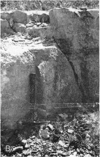
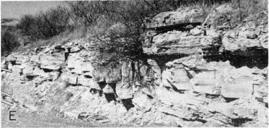
Eiss limestone member.--The thickness of the Eiss limestone is about 16 feet. It is divisible into three distinct units.
The upper part is a gray siliceous bench-making limestone (Pl. 4F), which becomes characteristically pitted when weathered. Coarse crystalline fossils stand out in relief on weathered surfaces. The thickness ranges from 1 to 2 1/2 feet. The middle part comprises several feet of gray and olive shale commonly with abundant crinoid and echinoid fragments, bryozoans, and brachiopods occurring in the lower part.
Plate 4F--Upper siliceous limestone bed of the Eiss limestone showing typical pitted weathering character. Along U.S. 50-S, SE NW sec. 17, T. 19 S., R. 8 E. (Photo by H.G. O'Connor)
The lower unit, ranging in thickness from 3 to 12 feet, is dark-gray to nearly black shaly limestone. The basal part is molluscan, but higher in the rock crinoid fragments, bryozoans, and the brachiopods Meekella, Chonetes, and Composita mingle with small snails and clams.
Stearns Shale
The average thickness of the Stearns shale is about 7 feet. It is gray, black, and green in the upper part and gray green or locally calcareous and cream-colored in the lower part. Red shale occurs near the middle in some places. It is of little importance as a source of ground water.
The Beattie limestone comprises two massive limestones averaging about 5 feet in thickness, separated by about 12 feet of shale. It is one of the principal aquifers of the Council Grove group and supplies many stock and domestic wells with ground water.
Beattie Limestone
Morrill limestone member.--The Morrill limestone ranges in thickness from about 3 1/2 to 6 feet. It exhibits various lithologic characters in different beds, which commonly are separated by thin shale. The upper part may be either soft or dense limestone, gray to yellowish brown, fossiliferous, with calcite vugs and geodes. The middle and lower parts are mostly molluscan or algal.
Florena shale member.--Measured sections of the Florena shale range from 8 to 15 feet in thickness. The upper 1 to 5 feet is unfossiliferous or only very sparsely fossiliferous. This part, which is gray, yellow, or black, commonly contains calcitic and siliceous vein fillings and geodes. In places, gypsum is associated with the geodes. The lower 6 to 9 feet is dark gray to black or gray and is abundantly fossiliferous. The brachiopod Chonetes is the most common fossil, but Derbyia, productids, and Composita are common. Echinoid and crinoid fragments and bryozoans are found locally. Small trilobites are sparsely present.
Cottonwood limestone member.--The Cottonwood limestone ranges in thickness from about 3 to 6 1/2 feet. Commonly it is a massive gray to creamy buff limestone that weathers light gray. There are one or more very thin shale partings. Abundant slender fusulines are characteristic (Pl. 6D). The fusulines are abundant only in the upper half or less of the Cottonwood member, and they are absent in the. lower part except for very sparse specimens locally near the top of this lower division. The lower part generally carries echinoderm fragments, bryozoans, and brachiopods and more or less commonly irregularly platy algal material. This lower part may be massive or slabby.
A rather decided fades change is observed in the Cottonwood limestone in tracing the unit from north to south across Chase County. South of Cottonwood River, in the drainage area of Jacobs Creek, it loses its characteristic massiveness and does not occur in conspicuous outcrops, as farther north (Pl. 5C). In the drainage area of Verdigris River, in southern Chase County, it is 3 to 5 feet thick. Sparse to abundant siliceous nodules are characteristic there; in some outcrops the upper fusuline zone consists of limy shale and the lower algal part is massive to slabby limestone.
Plate 5C--Characteristic conspicuous outcrop of the Cottonwood limestone north of Cottonwood River along highway K-150 in sec. 30, T. 19 S., R. 7 E. (Photo by H.G. O'Connor)
Eskridge Shale
Measured sections of the Eskridge shale show a thickness range from 23 to 38 feet and furnish record of marked changes in lithology. In an exposure in the NE sec. 19, T. 18 S., R. 7 E., 37 feet of red, green, and purple partly gypsiferous shale is exposed. The base of the formation is covered. No fossils were seen. In the N/2 SW sec. 3, T. 22 S., R. 9 E., the formation is 24 1/2 feet thick. The upper part is gray and green; a thin bed of pelecypod-bearing limestone occurs in red and green shale in the middle part, and a bed of lignitic platy material, nearly 1 foot thick, occurs 5 1/2 feet above the base. The Eskridge shale is not an important source of ground water; however, a few wells do obtain small supplies of water from it at shallow depths.
Grenola Limestone
The thickness of the Grenola limestone is about 45 feet. It is the chief aquifer for many wells in Chase County. The Neva limestone member is the most important aquifer.
Neva limestone member.--The upper unit of the Neva limestone is an algal and molluscan limestone bed, 1 to 6 feet thick. Locally it is a coquina of small shells, fossil fragments, and algal material. It is separated from the "main ledge" by gray fossiliferous shale, which ranges in thickness from a featheredge to as much as 9 feet. Echinoid spines and brachiopods are abundant in this part which in the southern part of the county is very calcareous shale or shaly limestone. The middle or main ledge is a gray massive limestone containing echinoderm fragments, brachiopods, and locally fusulines in the upper part and fusulines in the lower part. It appears brecciated and pitted in weathered exposures (Pl. 6E). It ranges in thickness from about 3 1/2 to 8 feet. Next below is a thin bed of gray to nearly black fusuline-bearing shale overlying about 1 foot of brownish-gray fusuline limestone that commonly has an upper crust composed principally of the brachiopod Crurithyris. A few inches of shale, locally containing algal material, lies above a pitted algal limestone, about one-half to a foot thick, which comprises the lower unit of the Neva member.
Salem Point shale member.--The average thickness of the Salem Point shale is about 9 feet. Buff limy nodular shale occurs in the upper part as a zone from one-half to 3 feet thick. The lower 5 to 7 feet is gray to gray-green or black thin-bedded to fissile shale.
Burr limestone member.--The Burr limestone comprises several limestone beds separated by shales. As seen in most exposures there is a limestone bed 0.3 to 1 1/2 feet thick at the top; this is underlain by 1 to 5 feet of gray-green or gray shale that seemingly is without fossils. The middle part is characterized by extremely platy limestone (Pl. 5E). This part is light gray or bluish and weathers light tan or yellow. At some outcrops there are shale partings in this zone and locally a thin layer rich in ostracodes is included. The lower part of the Burr limestone is gray and mottled shaly to slabby limestone, 2 1/2 to 7 feet thick, and containing an abundance of clams. Locally, several shale partings occur in this lower part. The average thickness of the member is about 12 feet.
Plate 5E--Burr limestone (a) showing platy porcelaneous middle part, (b) Legion shale, and (c) Sallyards limestone. Near C sec. 26, T. 19 S., R. 7 E. (Photo by H.G. O'Connor)
Legion shale member.--Commonly the upper few inches of the Legion shale is black, platy, and carbonaceous. Locally a thin limestone is exposed; it contains crinoid fragments, bryozoans, brachiopods, and pelecypods in the upper part. Mostly, however, this member of the Grenola formation comprises gray seemingly unfossiliferous shale. In places gray-green or buff colors are seen in the lower part. The overall thickness range is between about 3 and 8 feet.
Sallyards limestone member.--Gray platy to shaly limestone and gray shale characterize the Sallyards limestone. The thickness ranges from about 1 to 5 feet. Where thin the member commonly contains only pelecypods, but where thicker crinoid fragments, bryozoans, gastropods, and pelecypods are common.
Roca Shale
Measured sections of the Roca shale are uniformly about 16 feet thick. Approximately the upper half is gray or green shale, calcareous or with limy nodules. The lower part commonly contains two or three thin limestone beds separated by red, green, and purple shale. In a few places there is a small amount of gray clay in this lower part. In general the limestones are seemingly without fossils, but locally they contain small snails.
The Roca shale is of little importance as a source of ground water.
Red Eagle Limestone
The average thickness of the Red Eagle formation (Pl. 5F), which comprises two limestone members and a shale member, is about 14 1/2 feet. It is the principal aquifer for numerous wells where it is not too deeply buried below younger rocks.
Plate 5F--Red Eagle limestone showing characteristic development of each member; Elmdale hill, sec. 26, T. 19 S., R. 7 E. (Photo by H.G. O'Connor)
Howe limestone member.--The upper division of the Red Eagle (Howe limestone) is gray or gray-brown oolitic, algal, or foraminiferal limestone. In most places, part is earthy or chalky and soft. Commonly it does not form a conspicuous outcrop. The thickness ranges from about 1 to 3 feet.
Bennett shale member.--The thickness of the Bennett shale ranges from about 3 1/2 to 12 feet. In thicker facies the upper part is greenish gray to buff and is sandy. Where the Bennett is thinner, the upper part commonly is gray. The lower part is light to dark gray and calcareous. The Bennett shale is abundantly fossiliferous. Fossils include echinoid and crinoid fragments, bryozoans, and many common Lower Permian brachiopods.
Glenrock limestone member.--Measured sections of the Glenrock limestone range from 2 3/4 to 7 1/2 feet. Mostly the rock is light-gray to nearly white limestone and is chalky and brecciated. Cavernous weathering is characteristic. Generally the lower part comprises thin limestone and shale beds. The shale partings are gray, yellow, and nearly black. Fusulines are characteristic of the basal part and locally conodonts are abundant.
Johnson Shale
Light to dark-gray and greenish shale generally containing two or three thin limestone beds comprises the Johnson shale. The common thickness is about 22 feet. Generally the upper part is dark gray and carbonaceous. The middle part contains thin limestone beds of several textural types. The gray to green shale that occurs in the lower part contains a thin bed of nodular to well-bedded limestone, and in places gypsum occurs in this lower part.
The Johnson shale generally yields little or no water to wells; however, the lower part occasionally yields small supplies of ground water from gypsiferous or geodiferous zones.
Foraker Limestone
The Foraker formation is approximately 39 to 42 feet thick. Although the middle and lower members are unimportant as sources of ground water, the Long Creek limestone is an important aquifer, the upper geodiferous and cavernous part generally being very permeable.
Long Creek limestone member.--The Long Creek limestone comprises light-gray to yellow massive to slabby soft limestone and some shale. At most weathered outcrops the limestone is cavernous and vesicular-appearing. It is not resistant to weathering and forms an inconspicuous bench. Fresher exposures show geodiferous to somewhat cavernous rock. Colorless to pink or reddish-orange crystals of quartz and coarse-grained chert, generally associated with crystalline celestite or less frequently barite, characterize the top of the Long Creek limestone. In places there are nodules of pyrite and chalcopyrite that cause dark reddish-brown staining. Small clams and Osagia-like algae are somewhat sparse. Measured sections range from about 4 to 9 feet in thickness.
Hughes Creek shale member.--At measured exposures, the Hughes Creek shale ranges in thickness from about 18 to 25 feet. It is predominantly gray calcareous shale with a subordinate amount of limestone and is characterized by abundant fusulines throughout most of the thickness. A shaly to massive fusuline limestone 2 to 3 feet thick occurs commonly a short distance from the top. A shale zone containing bryozoans, brachiopods, and pelecypods occurs next above the "Thrall limestone bed" (Bass, 1936, p. 36) which is in about the middle of the Hughes Creek. The Thrall limestone is gray blocky fusuline-bearing limestone, commonly slightly more than 1 foot thick. Another rather persistent but thinner fusuline limestone occurs in the lower part of this member.
Americus limestone member.--The lowermost member (Americus) of the Foraker formation comprises an upper and lower limestone, separated by about 6 feet of bluish-black shale, rich in brachiopods. The upper limestone commonly is blue gray in its upper part and yellow in the lower. The common thickness is between 1 and 1 1/2 feet. Fusulines, crinoid fragments, and brachiopods are the common fossils. In the lower part, gray shaly to platy limestone about 2 feet thick containing brachiopods is underlain by less than a foot of black brachiopod-bearing shale below which is the Americus "main ledge," gray blocky limestone containing brachiopods and fusulines and about 1 1/2 feet thick. The total thickness of the Americus member is 11 feet or slightly more.
Admire Group
Hamlin Shale
The Hamlin shale is about 56 feet thick. It is of little importance as a source of ground water in this area.
Oaks shale member.--Exposed in only a few places, the Oaks shale is mostly gray to black. Measured sections range from 5 to 10 feet in thickness.
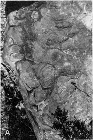
Houchen Creek limestone member. --Where measured, the Houchen Creek limestone ranges from 1 to 3 feet in thickness. This rock has distinctive lobate bedding (Pl. 5A), because it is composed partly of calcareous algae. Weathered outcrops display yellow-brown sandy-appearing "honeycomb" rock and dense gray algal limestone.
Plate 5A--Typical lobate-bedded algal Houchen Creek limestone, NE SE sec. 2, T. 20 S., R. 9 E. (Photo by R.I. Jindra)
Stine shale member.--In its few exposures in Chase County, the Stine shale comprises gray, red, and green shale and locally one or two thin limestone beds in its middle and lower parts. Lingula and other fossils are more or less common in places and sandy phases contain plant remains. Measured thicknesses range from 46 to 50 feet.
Five Point Limestone
The Five Point limestone has been found only at one place in Chase County; this is along the east county border in the Verdigris River valley. Several nearby exposures in Lyon County indicate that its properties are rather persistent. It is gray to brown massive commonly dense limestone. Well-preserved brachiopods, pelecypods, crinoids, and bryozoan fragments occur in a thin crust at the top of the bed together with numerous sharks teeth and fusulines. The thickness is about 2 feet. It is not an aquifer.
West Branch Shale
The West Branch shale is the oldest stratigraphic unit at the surface in Chase County. Along the Chase-Lyon County line in Verdigris River valley, it is from 25 to 30 feet thick. Coal or a carbonaceous streak and underclay occur generally near the top. The upper part is sandy and locally contains some sandstone or thin siltstone beds. There is a thin calcareous fossiliferous zone near the middle part, and the lower part is tan to gray with a limy zone near the base. No wells obtain ground water from the West Branch shale. In all except a very small area, it is too deeply buried to contain potable water.
Prev Page--Table of Contents || Next Page--Mineral Resources
Kansas Geological Survey, Chase County Geohydrology
Placed on web March 2001; originally published Aug. 1951.
Comments to webadmin@kgs.ku.edu
The URL for this page is http://www.kgs.ku.edu/General/Geology/Chase/pt1_intro.html