![]()
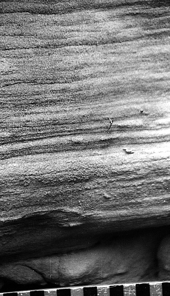
Fig. 11A. Sedimentary features in the Marmaton River quarry, Bourbon County, Kansas. Laminated sandstone at 3.0-3.2 m (9.8-10.5 ft) above base of Marmaton River quarry section; scale is in centimeters.
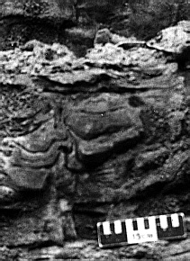
Fig. 11B. Sedimentary features in the Marmaton River quarry, Bourbon County, Kansas. Contorted cross-bedded sets, indicating rapid deposition, at 3.5-4.5 m (11.5-14.8 ft) above base of Marmaton River quarry section, Bourbon County, Kansas; scale is 15 cm (5.9 in) long.
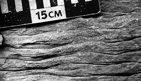
Fig. 11C. Sedimentary features in the Marmaton River quarry, Bourbon County, Kansas. Flaser-bedded units of interstratified ripple-laminated sandstone and shale, 5.5-7.0 m (18.0-23.0 ft) above base of Marmaton River Quarry Section, Bourbon County, Kansas; scale is 15 cm (5.9 in).
Well-log Signature. The laminated sandstone facies is indistinguishable from other sandstones on well logs due to resolution limits of gamma-ray and neutron logs.
Interpretation. Horizontally laminated sandstones consist of darker-colored (but hydrodynamically lighter) lamina that contain abundant sand-sized mica plates and carbonaceous plant fragments and of lighter-colored (hydrodynamically heavier) lamina made up almost entirely of quartz sand grains. This rhythmically laminated interval is within a section characterized by large-scale, cross-bedded sandstone units and flaser-bedded units of interstratified ripple-laminated sandstone and shale, with some contortion caused by soft-sediment deformation (fig. 11B,C). Indications are that all sandstone units in the Bourbon County exposures were rapidly deposited, suggesting that sandstone rhythmites probably represent short-term oscillations in current conditions. One possible mechanism for these oscillations could have been manifestation of tidal cycles. Pending future mathematical analyses, we postulate that these rhythmites may have resulted from tidal currents related to tidal cells that may have been amplified in bay settings between siliciclastic point-source accumulations.
Well-log Signature. These calcite-cemented, relatively shale-free intervals are probably represented as low gamma, low neutron spikes on gamma-ray and neutron logs. Some well logs show funnel-shaped signatures, perhaps representing cross-bedded sandstone overlying interstratified or flaser-bedded sandstone and shale (figs. 4, 5). The lenticular and discontinuous distribution of sandstone thicks (depicted on the sandstone isolith map of the Bandera Shale interval) reflects the lack of correlation between consecutive wells of this well-log signature (fig. 7).
Interpretation. The positions of cross-bedded sandstone beds between interstratified sandstone and shale strata suggests that they represent subaqueous dunes that were formed in response to marine processes. We postulate that the discontinuous nature of sandstone intervals interpreted on well logs may represent dunes, sand bars, and bar complexes. These sands may have been transported to the seaway by a fluvial system during a time of sea-level lowstand. Subsequent marine transgression resulted in the deposition of the Bandera Shale and the reworking of sand bodies by combinations of tide-generated and wave-generated currents.
Well-log Signature. Shales, particularly potassium-rich clay shales, tend to have both high gamma counts and high neutron values. In most wells, the Amoret Limestone Member lies directly above an interval with signatures similar to the one described above. Coals are not commonly detected using well logs in this portion of the Pennsylvanian section, perhaps due to the inherit thinness of many coal beds.
Interpretation. Shales may represent a variety of settings ranging from deltaic interdistributary bays to muddy marine shelves. The shale observed in Labette County between a coal seam and the overlying marine Amoret Limestone probably represents a transgressive mud deposited before waters cleared enough to support carbonate-secreting organisms in sufficient numbers to produce limestone.
![]()
Kansas Geological Survey
Web version June 24, 1998
http://www.kgs.ku.edu/Current/1998/brownfield/brownfield6.html
email:lbrosius@kgs.ku.edu