Kansas Geological Survey, Current Research in Earth Sciences, Bulletin 241,
part 2
Distribution of the Bandera Shale of the Marmaton Group, Middle Pennsylvanian of Southeastern Kansas--fig. 5
![]()
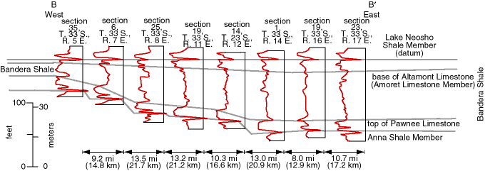
Fig. 5. Gamma-ray logs along cross section B-B', showing a portion of the Marmaton Group between south-central Cowley County and southwestern Labette County, Kansas, and illustrating the variation in stratigraphy and thickness perpendicular to the Bandera outcrop belt. See fig. 3 for location of cross section.
![]()
Kansas Geological Survey
Web version June 24, 1998
http://www.kgs.ku.edu/Current/1998/brownfield/fig5.html
email:lbrosius@kgs.ku.edu