Kansas Geological Survey, Current Research in Earth Sciences, Bulletin 241,
part 2
Distribution of the Bandera Shale of the Marmaton Group, Middle Pennsylvanian of Southeastern Kansas--fig. 11
![]()
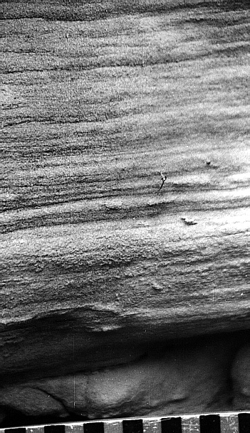
Fig. 11A. Sedimentary features in the Marmaton River quarry, Bourbon County, Kansas. Laminated sandstone at 3.0-3.2 m (9.8-10.5 ft) above base of Marmaton River quarry section; scale is 15 cm (5.9 in).
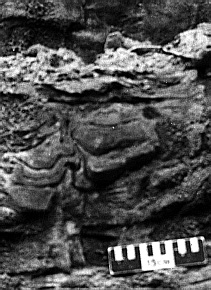
Fig. 11B. Sedimentary features in the Marmaton River quarry, Bourbon County, Kansas. Contorted cross-bedded sets, indicating rapid deposition, at 3.5-4.5 m (11.5-14.8 ft) above base of Marmaton River quarry section, Bourbon County, Kansas; scale is 15 cm (5.9 in) long.
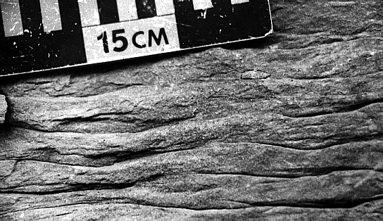
Fig. 11C. Sedimentary features in the Marmaton River quarry, Bourbon County, Kansas. Flaser-bedded units of interstratified ripple-laminated sandstone and shale, 5.5-7.0 m (18.0-23.0 ft) above base of Marmaton River Quarry Section, Bourbon County, Kansas; scale is 15 cm (5.9 in).
![]()
Kansas Geological Survey
Web version June 24, 1998
http://www.kgs.ku.edu/Current/1998/brownfield/fig11.html
email:lbrosius@kgs.ku.edu