![]()
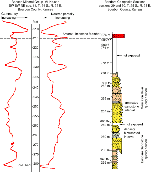
Figure 8. Comparison between well log signatures and a composite surface section from the Bandera quarry in Bourbon County, Kansas. Depths on the well log are measured from the drill rig's Kelly Bushing and are approximately equivalent to depth below the surface. Elevations above sea level are shown on the composite section. See fig. 3 for location of surface section.
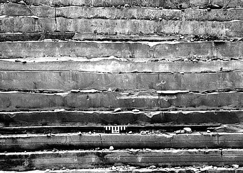
Fig. 9A. Sedimentary features in the Bandera Sandstone quarry, Bourbon County, Kansas. Interbedded sandstone and shale about 2 m (6.6 ft) above base of Bandera Sandstone quarry section; scale is 15 cm (5.9 in).
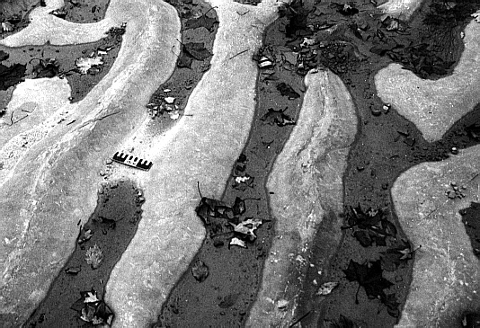
Fig. 9B. Sedimentary features in the Bandera Sandstone quarry, Bourbon County, Kansas. Regularly spaced ripple crests on bedding planes 0.5 m (1.6 ft) above base of Bandera Sandstone quarry section; scale is 15 cm (5.9 in).
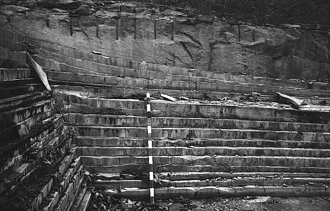
Fig. 9C. Sedimentary features in the Bandera Sandstone quarry, Bourbon County, Kansas. Dune feature loading down into interbedded sandstone and shale, 3.2 m (10.5 ft) above base of Bandera Sandstone quarry section; rod is 1.5 m (4.9 ft) long.
Olivellites sp. aff. O. plummeri is a highly sinuous, flattened, bandlike, horizontal, unbranched trace that ranges in width from 1.0 cm to 1.5 cm (0.4-0.6 in). It is bilobate with a very narrow medial ridge (fig. 10A). Medial ridges are less than 1 mm wide. Very fine transverse ridges on lateral lobes were visible on some slabs, but most of the slabs studied were sufficiently weathered so those lobes appeared unornamented. These traces formed an overlapping network suggesting that levels of bioturbation were high relative to sedimentation rate of overlying muds. This could be explained by alternating periods of rapid sand deposition followed by periods of mud deposition at very slow rates under quiet-water conditions. Originally described from shallow subtidal sandstones (Fenton and Fenton, 1937), Olivellites was thought to represent the grazing activities of mobile, deposit-feeding, epibenthic gastropods. Häntzschel (1962) considered Olivellites to be in the Scolicia group of gastropod traces. However, Yochelson and Schindel (1978) suggested that the trace-maker was an arthropod, and Knox and Miller (1985) described Olivellites from lagoonal, tidal flat, and distributary mouth bar facies.
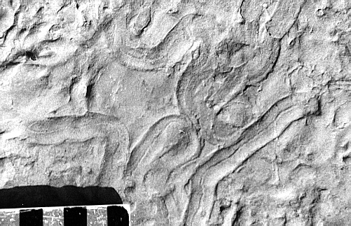
Fig. 10A. Olivellites, trace fossils in the Bandera Sandstone quarry, Bourbon County, Kansas, observed between 5.0 m to 6.0 m (16.4-19.7 ft); scale is in centimeters.
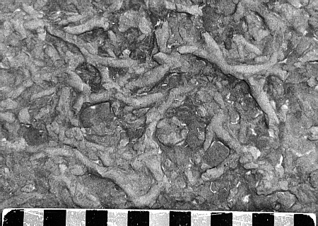
Fig. 10B. Palaeophycus sp., trace fossils in the Bandera Sandstone quarry, Bourbon County, Kansas, observed between 5.0 m to 6.0 m (16.4-19.7 ft); scale is in centimeters.
Palaeophycus sp. are straight to slightly sinuous tubular traces that are typically elliptical to nearly circular in transverse cross section. They are typically smooth, horizontal, and unbranched with diameters ranging from 0.4 cm to 1.0 cm (0.16-0.39 in). Häntzschel (1962) believes that it could also represent other organisms. Regardless of exact origin, these traces are found forming dense networks that make some traces appear to be branched (fig. 10B), suggesting environments similar to those of Olivellites, with alternating periods of rapid sand deposition followed by periods of very low rates of mud deposition under quiet-water conditions.
Olivellites and Palaeophycus may represent opportunistic, facies-crossing ichnotaxa that are very abundant locally but are members of low-diversity assemblages (Archer and Maples, 1984). This situation suggests strata deposited in stressed environments (Buatois et al., 1997). Opportunistic organisms can exist and perhaps flourish under conditions that discourage or exclude most other organisms (Ekdale, 1985; Martino, 1989).
Well-log Signature. The interbedded sandstone and shale facies would probably have an intermediate gamma count and neutron value and would be indistinguishable from the signatures of a silty or sandy shale or of a clay-rich sandstone unit. Such a signature, seen in the intervals between 265 ft to 270 ft (80.7-82.3 m) and 240 ft to 245 ft (73.1-74.7 m) on the Benson Mineral Group well in Bourbon County, probably represent this mixed rock facies (fig. 8).
Interpretation. Intervals of slabby, well-sorted, fine-grained sandstone with intercalated, millimeter-scale shale lamina represent alternation of relatively high energy sand-sedimentation events separated by low-energy suspension-depositional conditions. The characteristics of the sandstone slabs, ranging from ripple cross-stratified to homogenous, indicate that each slab of sand was deposited rapidly. Ripple-cross-stratified slabs either lack or have very sparse trace fossils on their upper surfaces. They may represent sands washed into areas with either constant or regularly occurring currents, while homogenous slabs may represent either sands that were completely reworked by bioturbation or deposited very rapidly in areas that are not usually traversed by currents capable of moving sand. Slabs of homogeneous sandstones, in at least one interval, are capped with dense networks of horizontal feeding or crawling trails. The thin mud laminae would generally indicate relatively short periods of time between high-energy events. Dense networks of trails, along with homogenization of slabs capped by burrows, suggest that (1) enough time elapsed between events to allow bioturbation to take place in settings with this combination of characteristics and (2) mud deposition was slow.
The location of the Bandera Sandstone quarries north of a so-called sedimentary thick (indicated by the isopach map of the Lake Neosho-Anna) suggests that these localities were in a marginal, perhaps marine-influenced setting on the edge of a siliciclastic complex. High-energy, sand-depositing events were storms, fluvial floods, or a combination of both. Sands were deposited as splays or washover fans, emanating from the siliciclastic sediment thick, either as flood deposits from deltaic distributaries or as storm deposits swept from marine bars into areas that were low energy under fair-weather conditions. Sands deposited in quiet-water environments were later reworked by a low-diversity fauna, leaving Olivellites trails and Palaeophycus burrows. Both lithologic data and trace-fossil distributions support the interpretation that the interbedded sandstone and shale facies was deposited in a shallow marine setting above storm wave-base, but possibly below fair-weather wave base.
![]()
Kansas Geological Survey
Web version October 15, 1998
http://www.kgs.ku.edu/Current/1998/brownfield/brownfield5.html
email:lbrosius@kgs.ku.edu