Kansas Geological Survey, OGI 21
Originally published in 1960 as Kansas Geological Survey Oil and Gas Investigations 21. This is, in general, the original text as published. The information has not been updated. An Acrobat PDF version (5.4 MB) is also available.
Kansas produces large amounts of natural gas, and large quantities are consumed within the state, especially in the eastern part. At present gas is stored in 14 projects. Geologic conditions in the state are such that possibilities for storage in more underground reservoirs is very promising.
Annually more than 500 billion cubic feet of natural gas (14.65 psia) is produced in Kansas. Presently, about 70 percent of the production comes from the Kansas part of the Hugoton Gas Area, which extends into Oklahoma and Texas. A large part of the Hugoton gas is transported across Kansas. Very small amounts of gas, probably less than one percent of the total, come from eastern counties. The eastern area, however, contains many depleted pools, some of which are of moderate size and all of which are at shallow depths. Underground storage of gas in depleted pools has been practiced in Kansas for many years (Jewett and Abernathy, 1945, p. 147). There are now 14 projects in operation and it is believed that the need for underground storage facilities will increase for several years.
Because of the seasonal demand for natural gas as a fuel, underground off-season storage has become a significant factor in the overall economy of gas production, transmission, and consumption. Kansas, located in the heart of the nation geographically, contains a major source of natural gas supply (Federal Power Commission map, Dec. 31, 1958). There were 494,000 residential consumers in Kansas during 1958, utilizing 64,486,000 M cubic feet at an average value of 60.4 cents per thousand (Minerals Yearbook, v. 2, Fuels, 1958). Commercial consumers totaled 61,000 during the year. These used 40,147,000 M cubic feet of gas valued at 39.1 cents per thousand. Other users of natural gas in Kansas during 1958 consisted of makers of carbon black, drillers, refineries, and other industrial users. During the year they consumed 202,557,000 M cubic feet valued at 20.4 cents per thousand.
The marketed production of gas in Kansas in 1958 amounted to 561,816,000 M cubic feet and was valued at 11.4 cents (average) per thousand cubic feet at the well head. Interstate movement of gas accounted for 424,547,000 M cubic feet. Quantity received was 237,707,000 M cubic feet, mostly from west-south-central United States including Arkansas, Louisiana, Oklahoma, and Texas. Consumption within Kansas amounted to only 362,280,000 M cubic feet or 64 percent of the marketed production.
Development cost of gas storage projects by private industry is difficult to determine and not necessarily useable because comparison between companies utilizing dissimilar storage reservoirs would be futile. During 1959, however, Cities Service Gas Company applied for permission from the Federal Power Commission, which has jurisdiction over interstate movement and sale of fuels, to construct several storage projects along its lines. The large Denton Storage Area in Elk County was listed at a cost estimated at $4,337,000.00. The Ferguson and Denton fields will be operated as a single unit. About 200 old wells and 35 new wells will be utilized. Finished, the total storage capacity will be about 16 billion cubic feet, making it the largest in Kansas.
It is obvious that a large portion of the interstate marketed gas from Kansas is dependent on the consuming area of north-central United States for an outlet. Industrial users assume some of the seasonal slack of residential users, but even so, the need to flatten out the annual curve of consumption and market, to utilize the pipeline capacity the year around, and to stabilize the gas producing industry in Kansas makes off-season storage of gas in underground reservoirs near transmission lines and enroute to market both desirable and necessary.
Gas was discovered in Kansas about 1860, in the Forest City Basin. In 1870, gas was discovered in the Cherokee Basin, and in 1888 on the Central Kansas Uplift. By 1910, numerous industries had been established on the basis of cheap natural gas available in eastern Kansas counties. This is signified in the 1908 production, which exceeded 80 billion cubic feet of gas. Later, insufficiency of new supplies of natural gas forced out of business those pipelines dependent upon declining reserves.
Kansas now ranks fifth among gas producing states and fourth in reserves. A significant portion of Kansas annual gas production is being exported, but estimates of amounts of natural gas used for industry in the state have risen within the last few years. During 1958 natural gas was produced from 49 counties in Kansas. At the end of 1958, there were 30 gas fields in Kansas under state jurisdiction, and monthly proration schedules were issued for 22 fields. Unprorated gas fields in Kansas are limited by statute not to run in excess of 25 percent of the open-flow capacity.
Cumulative natural gas production in Kansas surpassed the 8,000,000,000 M cubic feet mark in 1959. This volume is more than double the total production of natural gas in Kansas prior to 1949 and four times the amount produced previous to 1938. Since 1956, annual gas production has exceeded one half trillion cubic feet and since 1943 has been greater than one hundred billion cubic feet annually. In 1958 production was 595.2 billion cubic feet, an all-time high for the state. By far the greatest amount of Kansas gas production has come from the prolific Hugoton Gas Area in western Kansas and adjoining areas of the Texas-Oklahoma Panhandles. In recent years gas production from outside and stratigraphically beneath the Hugoton has been gaining in importance. Pennsylvanian beds principally in eastern Kansas have supplied the second largest amount of gas, about 32 percent of the total. Lesser amounts have been obtained from rocks of Mississippian, Ordovician, and Cambrian age.
The Hugoton Gas Area proper was opened in 1922 by a well in sec. 3, T. 35 S., R. 34 W., Seward County. A rapid development of the huge gas reservoir in southwestern Kansas came in the early 1940's. By the end of 1949, the number of producing wells in the field passed the 2,000 mark and the area encompassed 2,000,000 acres. At the end of 1958, there were more than 3,800 producing wells in the Kansas part of the Hugoton Gas Area.
The Hugoton Gas Area alone accounted for about 69 percent of the total Kansas yield of gas in 1957, 73 percent in 1956, 85 percent in 1955 and 1954, 92 percent in 1953, 90 percent in 1952 and 1951, 88 percent in 1950. This shows a recent rise in importance of gas production within Kansas outside the limits of the Hugoton Gas Field.
The locations of active gas fields and of major gas pipe lines are shown on Figure 1. The names and locations of gas storage projects and abandoned gas fields are indicated on Figure 2.
Figure 1—Map of Kansas showing location of active gas fields and main gas transmission lines.
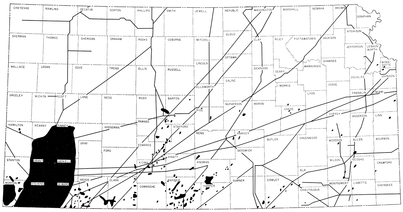
Figure 2—Map of Kansas showing location of abandoned gas fields and active gas storage projects.
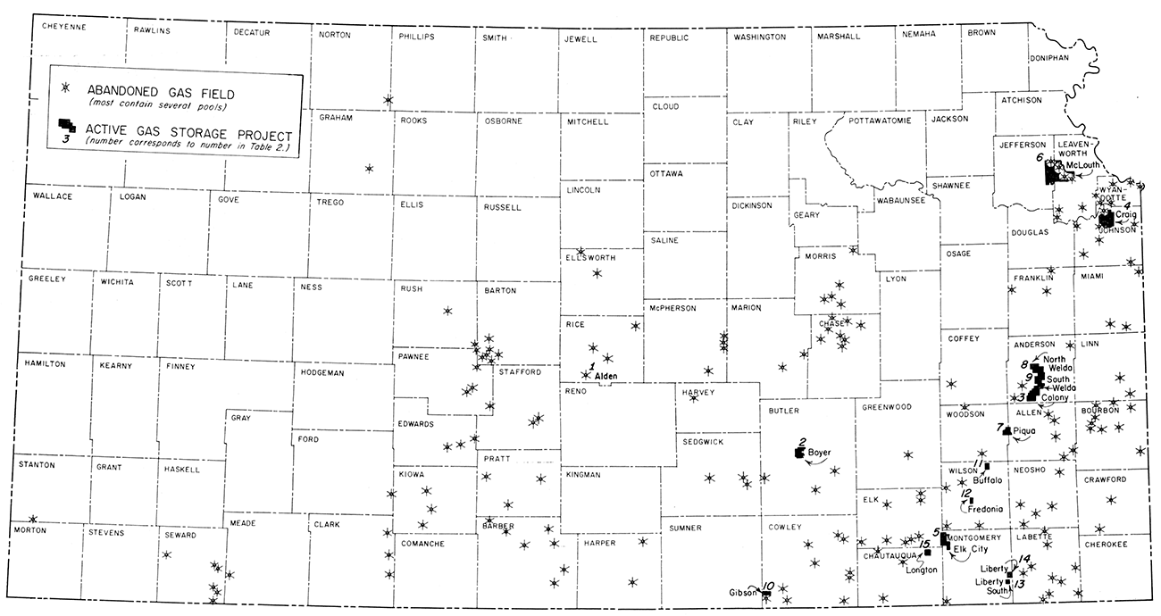
Figure 3 shows distribution of outcrop areas of rocks of various geologic systems in Kansas. Outcropping and other rocks above the crystalline basement complex (Precambrian) and data more or less pertinent to gas storage are listed in Table 1. It is deemed that interest in gas storage at the present time primarily concerns porous rocks that are in structural positions that cause them to be actual or potential reservoirs. These are the conditions that obtain in the presently operating gas storage projects that are described in another part of this report. In Kansas almost all rocks above the Precambrian floor are sedimentary; many of the layers are relatively porous and permeable. All these rock units are in positions that are close to horizontaL Only on the flanks of major uplifts and very locally elsewhere are dips measured in angles of more than a fraction of a degree. Because of the general scarcity of faulting and steep folding, anticlinal and domal structures are relatively simple and easily defined (Jewett, 1951, 1958, 1960).
Figure 3—Generalized areal geologic map and cross section of Kansas.
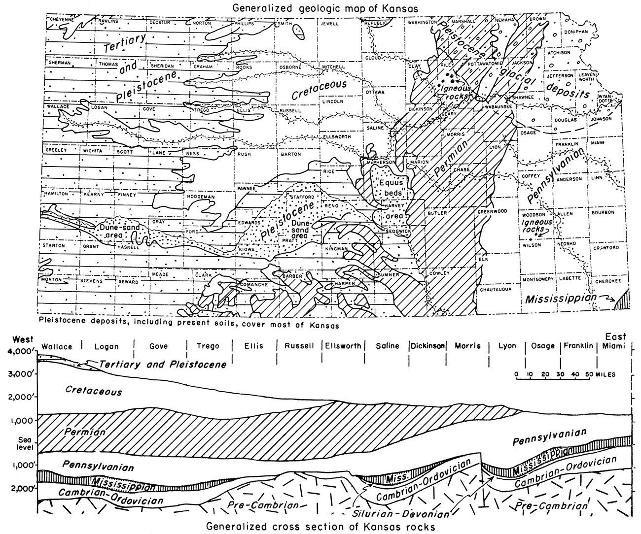
Table 1—Stratigraphy of Kansas in Reference to Gas Storage in Rocks
| System | Smaller stratigraphic divisions |
General data | Remarks in reference to gas storage |
Special references to literature |
|
|---|---|---|---|---|---|
| Neogene | Pleistocene or "Quaternary" |
Clays, silts, sands, gravels, boulders, in surficial deposits, mostly unconsolidated, comprising soil, valley fillings, stream terraces, deposits of loess, and the glacial deposits of northeastern Kansas. Thickness as much as 300 feet. | Fresh-water bearing beds of great importance, not suited for gas storage because of shallow depth and lack of impervious sealing beds. Add to overburden. See Fig. 3 for distribution. | Moore and others, 1951, p. 13; Frye and Leonard, 1952; Geological Survey ground-water reports. | |
| "Tertiary" chiefly included in Ogallala Formation | Widespread in central and western Kansas, locally in eastern. Mostly stream deposits; where thin, high above present drainage. Sands, gravels, "mortar beds." Most prevalent in High Plains area. Thickness about 350 feet or less. | Fresh-water-bearing beds of importance. Shallow and generally lack impervious seals. See Fig. 3 for surface distribution. | Moore and others, 1951, p. 17; Frye, 1949; Smith, 1940; Frye, Leonard, and Swineford, 1956; Geological Survey ground-water reports. | ||
| Cretaceous | Pierre Shale, Niobrara Chalk, Carlile Shale, Greenhorn Limestone, Graneros Shale, Dakota Formation, Kiowa Shale, and Cheyenne Sandstone |
In outcrops and subsurface in much of central and western Kansas. Mostly marine in origin, supposed nonmarine deposits in lower part. Clayey and calcareous shales predominant, fine-grained chalky, platy limestones constituting most of the lower middle part. Plentiful sandstone in the lower part. Total thickness about 2,750 feet. | Sandstone beds, mostly in lower part, offer probable reservoirs in many areas. Surface distribution shown in Fig. 1. Not present in areas of greatest gas consumption. | Moore and others, 1951, p. 17; Plummer and Romary, 1942; Latta, 1946. | |
| Jurassic | Morrison Formation | Subsurface in southwestern Kansas. Chiefly shale, mostly green, some gypsum and pink jasper-like chert. Thickness as much as 275 feet. | Probably lacks sufficient porosity. | Landes and Keroher, 1938. | |
| Triassic | Dockum (?) Group | Outcrops in small area in Morton County are believed to be of Triassic age and to be properly classed as part of Dockum Group. These rocks identified in subsurface in Morton and Stanton Counties. Chiefly red siltstone and buff and white sandstone; some gypsum. Thickness about 40 feet. | Sandstone bodies probably offer structural and stratigraphic trap-like reservoirs. | McLaughlin, 1942. | |
| Permian | Ochoan and Guadalupian Stages | Surface in southwestern and subsurface in western Kansas. Chiefly red beds of fine-grained sandstone, siltstone, and silty shale. Dolostone, gypstone, and anhydristone in middle part; much salt in subsurface. Thickness about 900 feet. | Sandstones are fine grained and of low porosity. Artificial cavities easily made in salt. | Moore and others, 1951, p. 37; Swineford, 1955; Kulstad, 1960. | |
| Leonardian Stage including lower part of Nippewalla Group and the Sumner Group | Surface in southwestern Kansas and subsurface in western Kansas. Chiefly red beds of siltstone, fine-grained sandstone, and silty shale. Thick deposits of salt in the subsurface. This division has the Stone Corral (subsurface marker) Formation in the upper-middle part (and lies above more calcareous rocks of Wolfcampian age). Thickness is about 1,200 feet. | Thick salt deposits suited to development of washed-out cavities for liquid storage but probably little potential in these rocks for natural gas storage in natural traps. | Moore and others, 1951, p. 38; Swineford, 1955; Kulstad, 1960. | ||
| Wolfcampian Stage containing Chase, Council Grove, and Admire Groups |
Outcrops in east-central Kansas, subsurface west of outcrop belt. Chiefly marine shales and limestones. Thicker shales commonly varigated colors. Limestones massive to thin bedded. Shales mostly lack carbonaceous materials. Lower part contains some sandstone. Thickness about 500 feet. | Sandstones in lower part (and some not differentiated from sandstones in underlying Wabaunsee Group) bear gas and are suitable reservoirs for storage in anticlinal structures as along Nemaha Anticline. Great Hugoton gas pool is in deeply buried stratigraphic trap in southwestern Kansas. | Moore and others, 1951, p. 41; Moore and others, 1951a; O'Connor and others, 1953; Lee, 1949; Jewett, 1949, p. 32. | ||
| Pennsylvanian | Wabaunsee, Shawnee, Douglas, and Pedee Groups |
Principally shales, limestones, and sandstones; a few thin coal beds. Sandstones lenticular or elongated. Thickest formations chiefly shale as much as 200 feet thick. Solid limestone sections generally less than 50 feet thick. Sandstones generally silty, carboniferous, and clayey, as much as 50 feet thick. Many oil and gas traps. Maximum thickness about 750 feet. | Sandstones throughout section, but more extensive in lower part, offer many reservoirs in an area extending many miles west of outcrops. | Moore and others, 1951, p. 53; Jewett, 1949, p. 32; Jewett and Abernathy, 1945, p. 29. | |
| Lansing, Kansas City, Pleasanton, Marmaton, and Cherokee Groups |
More or less similar to units next above. Many oil and gas traps, especially in Lansing and Kansas City limestones and sandstones and in sandstones in Cherokee Group. Thickness about 1,250 feet. Outcrop belt in eastern Kansas, Kansas City area to Oklahoma line, subsurface in all Kansas west of outcrop area. | Potential storage reservoirs in many parts of section. Sandstones in lower part are suited as reservoirs in many small anticlinal structures in eastern Kansas. Important in Kansas City area. | Moore and others, 1951, p. 78; Jewett and Abernathy, 1945, p. 31; Jewett, 1949; 1954; Lee and others, 1946. | ||
| Atokan (Bendian) and Morrowan Stages |
Oil-bearing rocks of lower-Middle and of Lower Pennsylvanian age in deep subsurface in southwestern Kansas. Total thickness may be 1,000 feet. ("Basal conglomerate" of various ages within the Pennsylvanian System contains oil pools in several places.) | Storage possibilities probably of little interest because of depth greater than necessary and greater than that of other suitable rocks in same areas. | Moore and others, 1951, p. 102. | ||
| Mississippian | Chesteran, Meramecian, Osagian, and Kinderhookian Stages |
Chiefly massive limestones. Subsurface only, except small outcrop area in southeast corner of state. Contains lead and zinc ores in southeastern Kansas. Many oil traps, especially not far below upper eroded surface that cuts across various formations. Average thickness in eastern Kansas about 350 feet, northeastern Kansas about 500 feet, southwestern Kansas as much as 1,800 feet. | Probably of little interest at present time. | Lee, 1940; Moore and others, 1951, p. 107; Jewett, 1959. | |
| Mississippian or Devonian |
Boice Shale and Chattanooga Shale |
Dark to light greenish-gray shale, silty or dolomitic, some red; also black and gray shale. Generally not more than 100 feet thick. | "Misener" sandstone locally at base of Chattanooga proposed for storage in Rice County. | Moore and others, 1951, p. 111. | |
| Devonian and Silurian |
"Hunton" Limestone | Principally dolostones, some limestones. Identified in Kansas only in central and northeastern parts. Maximum known thickness 435 feet in Nemaha County, minimum depth about 2,000 feet in Jefferson County. | Probably of little interest. | Moore and others, 1951, p. 112; Lee, Leatherock, and Botinelly, 1948; Lee and others, 1946. | |
| Ordovician | Sylvan Shale or Maquokota Shale |
Greenish-gray, silty, dolomitic shale restricted principally to area of ancient Northeast Kansas Basin. Maximum known thickness about 155 feet. | Probably of little interest. | Moore and others, 1951, p. 117; Jewett, 1954a. | |
| Viola Limestone (Kimmswick) |
Dolostone and limestone. Subsurface in most of state, but absent on principal uplifts. Thickness as much as 300+ feet. | Probably of little interest. | |||
| Simpson Group | Includes Platteville Formation, St. Peter Sandstone, and lower beds. Dolomitic limestones and sandstones; thickens from beveled edge to about 100 feet. | Probably of interest in the future. | Leatherock, 1945. | ||
| Arbuckle Group |
Cotter and Jefferson City Dolostones |
Mainly coarsely granular, cherty dolostones. Featheredge in northern Kansas to 650 feet in Cowley County. | Moore and others, 1951, p. 116; Keroher and Kirby, 1948; Jewett, 1954, p. 55; Jewett, 1954a. | ||
| Roubidoux Sandstone |
Sandy dolomite and fine-grained sandstone. Thickness commonly 150 to 200 feet. | Important source of fresh water in southeastern Kansas. | |||
| Cambrian | Gasconade Dolostone and VanBuren Formation |
Mainly cherty, coarse-grained dolostones. Gunter Sandstone in basal part of Van Buren Formation. Beveled edge to 200 feet thick or possibly more in eastern and southeastern Kansas. | |||
| Eminence Dolostone |
Cherty, buff to white, very coarsely granular and crystalline dolostone. Beveled edge to about 150 feet in eastern Kansas, 40 to about 90 feet in west-central Kansas. | ||||
| Bonneterre Dolostone | Glauconitic, noncherty dolostone. Beveled edge to about 150 feet in ancient basins. | ||||
| Lamotte Sandstone | Ill-sorted, round to angular, coarse- to fine-grained sandstone. Average thickness about 80 feet. ("Granite wash" of various ages lies on Precam- brian rocks in several parts of Kansas.) | Moore and others, 1951, p. 122. | |||
| Precambrian rocks | Igneous and metamorphic rocks of the basement complex. Underlie all of state; nearest to land sur- face in Nemaha County in northeastern Kansas, at greatest depth in southwestern part of state. | Jewett, 1954, p. 56; Farquhar, 1959. | |||
Discussions of Kansas stratigraphy are found in many publications, especially of the Kansas Geological Survey. Attention is called to Bulletin 89, "The Kansas Rock Column" by Moore and others (1951), and to a chart "Graphic Representation and Classification of Rocks in Kansas" (Jewett, 1959). Here are presented characteristics of rocks of the various geologic systems (Table 1 and Fig. 3) with special reference to porous beds. The rocks are discussed in order of increasing age, or in the order in which they occur downward in the earth. As shown in Figure 3, older rocks are in general at shallower depth in the eastern part of Kansas than in the western part.
For convenience, Kansas rocks may be divided arbitrarily into seven main structural categories. These divisions are defined mainly by their structural distinctions each from the other. Of the seven divisions, four (Neogene, Mesozoic, Permian-Pennsylvanian, and Mississippian) are present at the surface, but the others, (Devonian-Silurian, Ordovician-Cambrian, and Precambrian) are known in Kansas only from information obtained by deep drilling.
Here are included the "Quaternary" and "Tertiary" deposits that constitute a widespread more or less continuous blanket concealing the structural features in the older, consolidated bedrock. These rocks are almost entirely unconsolidated and consist of debris derived physically from older rocks; they are nonmarine in origin. They comprise alluvium in river valleys under flood plains and in terraces, and widespread sheets of loess, dune sand, and, in northeastern Kansas, glacial deposits, as well as the comparatively thick alluvium of the High Plains. The thickness of "Quaternary" deposits may range locally to 500 feet but generally it is less than 100 feet. The "Tertiary" Ogallala Formation of western Kansas has a maximum thickness of about 400 feet. There are comparatively thin but wide-spread deposits of probable "Tertiary" age in eastern Kansas.
In western and central Kansas, in the northeastern glaciated part of the state, and in major and some minor stream valleys elsewhere, deposits of Neogene age are important reservoirs for fresh water; safeguards against pollution by oil and gas field wastes are important. In addition to their being impractical for gas storage because of being freshwater aquifers, the Neogene beds lack impervious seals or sufficient overburden above what otherwise might be storage reservoirs.
Although there are deposits in western Kansas believed to be of Jurassic and Triassic age (Table 1), most of the Mesozoic rocks of the state are Cretaceous. Strata of Cretaceous age are spread across all of northwestern Kansas and as far eastward as central Kansas (Fig. 3). These rocks consist of brown, ferruginous sandstones, dark clayey shales, chalky limestones, and some deposits of clay. No oil is known to occur in Mesozoic rocks in Kansas, but gas in moderate amounts has been produced near Goodland, in Sherman County, in a part of the Cretaceous section. Sandstone is characteristic of the lower part of the Mesozoic section, in the Dakota Formation, the Cheyenne Sandstone, and locally in Triassic rocks. Sandstones in the wide-spread Dakota Formation are lenticular within rock that chiefly is clay. Commonly the sandstone bodies, some of which are believed to be littoral and some alluvial deposits, are elongate and narrow. They are in form somewhat similar to the oil- and gas-bearing "shoestring sands" in the Cherokee Group (Pennsylvanian) in eastern Kansas. The Cheyenne Sandstone is more sheetlike than most of the sandstones in the Dakota. Porosity and permeability of these rocks are high. They are interesting as potential reservoirs for gas storage.
Sandstone-bearing Cretaceous rocks are present in the subsurface west of their outcrop belt, which is along the eastern border of the Cretaceous outcrop area (Fig. 3). Thickness of overburden, generally increasing westward, is about 2,000 feet in northwestern Kansas.
As shown in Table 1, the thick Permian-Pennsylvanian section in Kansas, ranging to about 6,000 feet in southwestern Kansas, comprises many kinds of rocks. The youngest and uppermost parts of this rock section, however, that are of present interest in reference to natural gas storage are believed to be in the lower part of the Permian and in the upper part of the Pennsylvanian. Lenticular sandstones, probably filling river valleys, occur in that stratigraphic zone (Jewett, 1959). In passing it may be mentioned that thick salt deposits higher in the Permian beds are suitable for washed-out cavities. Such cavities, presently used for storing liquids, contain extensive mined-out space available for storage of gas (Jewett, 1956).
The great Hugoton gas pool, by definition of the Kansas Nomenclature Committee limited to the Chase Group of rocks, in southwestern Kansas (Fig. 1) is in a stratigraphic trap in Lower Permian (Wolfcampian) rocks. Gas accumulation there is controlled mainly by the lateral gradation of porous dolomitic marine beds up dip into fine-grained dense, seemingly nonmarine strata farther west. Storage of gas in the Hugoton Area can be expected in the foreseeable future to be feasible as a gas-pressure maintenance program.
Known oil and gas reservoirs are present throughout almost the whole Pennsylvanian rock section in Kansas. Many of the hydrocarbon accumulations are in traps that are "structural" in origin, although concentrations that commonly are said to have taken place because of lateral changes in porosity, as in "shoestring sands", are plentiful.
Pervious sandstones in the upper part of. the Pennsylvanian section are mentioned above because some of the uppermost ones are not clearly defined from some that are classed as being in the Lower Permian. Other "shoestring sand" type channel fillings and sandbars, representing local deposits of pervious materials, occur throughout most of the Pennsylvanian column, but they are most prevalent in the Douglas and Pedee Groups and especially in the Cherokee Group. Sandstones in any part of the Pennsylvanian should not be overlooked, however. In addition to sandstones, some of which are more or less sheetlike, the Lansing and Kansas City Groups contain in central Kansas, more or less characteristically, open-textured oolitic zones that are productive in many places. Examples of oil and gas production from Lansing and Kansas City limestones are the Cunningham field in Kingman and Pratt Counties, the Macksville field (abandoned) in Stafford County, and the English field in Edwards County. Oil and gas pools in Pennsylvanian sandstone are very numerous in eastern Kansas (Jewett, 1954).
As shown in another part of this report, Cherokee sandstones are most extensively used for gas storage at present. It is reasonable to expect that sandstones in the Pleasanton, Marmaton, and Cherokee Groups in the area near Kansas City will be of increasing interest as potential storage reservoirs.
Composed chiefly of limestone and often called the "Mississippi lime", Mississippian rocks underlie all of Kansas except on two major uplifts. They are absent in the area of the Nemaha Anticline in a belt extending from Nemaha and Marshall Counties on the northern . border southward to Butler County. In the Central Kansas Uplift area there are no Mississippian rocks in a large area extending southeastward from Decatur, Norton, and Phillips Counties in the north to Pawnee, Stafford, and Reno Counties. Thickness of these rocks ranges from a featheredge on the flanks of the late-Paleozoic uplifts to about 1,800 feet. The maximum thickness of Mississippian rocks in Kansas is believed to be in or near Meade County in the southwest part of the state.
A very consequential amount of natural gas has been produced from Mississippian rocks in Kansas. It is possible that partly depleted gas reservoirs may at some time be of value for gas storage. Counties that produce large amounts of gas from Mississippian rocks include Barber, Harvey, Harper, Kingman, Kiowa, and Meade. Mississippian gas pools are known in several other central and western counties.
In much of Kansas, Mississippian limestones are underlain by a rock section that is chiefly shale. This unit, generally less than 100 feet thick, probably is in part Mississippian in age and in part Devonian. Main divisions are the Boice Shale (above) and the Chattanooga Shale (Table 1). In places the shale is an effective "cap rock".
In Kansas, Devonian and Silurian rocks, together or in places where either of the two is present, commonly are called "Hunton" Limestone. Thickness nowhere is more than a few hundred feet. These rocks have been identified in the Forest City, Salina, and Sedgwick Basins. They lie unconformably below the Chattanooga (or Boice) Shale and unconformably above various older rocks. A small amount of gas has been produced from "Hunton" rocks in Kansas.
Youngest Ordovician rocks in Kansas are shale beds, some of which are silty and dolomitic, known as Sylvan, or sometimes Maquoketa Shale. These deposits now are almost confined to the area of the old Northeast Kansas Basin, an area in eastern Kansas northeast of a line from Phillips County to Cowley County and northwest of a line from Cowley County to Miami County. These deposits are of some importance as a "cap rock" above Simpson and Viola oil pools; little or no gas has been found in the Sylvan in Kansas. The known thickness ranges from a featheredge to about 155 feet.
Limestone and dolostone beds that are believed to be of Middle Ordovician age and are assigned to the Viola Limestone are widespread in Kansas but are not present in the areas of major uplifts. The Viola is known to contain gas pools in a few counties, including Pratt, Reno, and Stafford. Hydrocarbon accumulations in these beds are mostly in structurally high areas in which deep weathering took place before burial under less-pervious sediments. Thickness ranges to slightly more than 300 feet.
It seems possible that sandstones in the Simpson Group of Ordovician rocks in Kansas at some time may be utilized as reservoirs for gas storage. These rocks are absent from major uplifts, but elsewhere in the state they are widespread. Simpson gas pools are known in several counties, including Barber, Comanche, Harper, Pawnee, Rice, and Sumner. The thickness of the group commonly is less than 100 feet. Depths to the known gas pools range from about 3,300 feet in Rice County to about 4,860 feet in Barber County. In the Kansas City area, depth to Simpson rocks is about 1,550 feet.
The term "Arbuckle" is used in more than one way. According to accepted stratigraphic classification, the Arbuckle Group in Kansas comprises strata below the Simpson Group and above the Bonneterre Dolostone. Thus both Lower Ordovician and Upper Cambrian rocks are included (Jewett, 1959; Table 1). For convenience, however, "Arbuckle" frequently is used for all Paleozoic rocks below Simpson beds and above the Lamotte Sandstone or other detrital basal accumulations on Precambrian rocks.
Arbuckle rocks are absent from the northern part of the Nemaha Anticline and adjacent areas as far west as eastern Washington County and northeastern Clay County; from higher parts of the Central Kansas Uplift in Barton, Ellis, Rush, and Russell Counties; and from the northern part of the same uplift (or the Cambridge Arch) in Decatur and Norton Counties. All divisions of the group are not distributed equally. The Cotter and Jefferson City Dolostones are absent from northern Kansas. Thickness of this upper part of the Arbuckle in other parts of the state ranges to about 650 feet. The Roubidoux is believed to be the most widely distributed Ordovician formation in the state; it is probably thickest in the southeastern part. The Gasconade and Van Buren Formations have been identified only in eastern and south-central Kansas. The thickness, greatest along the eastern and southern borders of the state, exceeds 200 feet. The Gunter Sandstone is the basal member of the Van Buren Formation. Locally it is 45 feet thick. The Eminence Dolostone is restricted to small areas in eastern and western Kansas. Its maximum thickness in Kansas is believed to be in eastern Kansas, where about 150 feet has been identified. Gas storage seemingly is possible but not now practicable in Arbuckle rocks.
The Bonneterre Dolostone is widespread in eastern and western Kansas but is believed to be absent from the central part of the state. Its maximum known thickness is nearly 200 feet.
Clastic deposits overlie much of the Precambrian rock surface in Kansas. Lamotte Sandstone is restricted as a name for these basal deposits by some geologists to detrital sediments that are unconformable above Precambrian rocks and conformable below Bonneterre Dolostone (Keroher and Kirby, 1948, p. 23). Others include detritus overlain by formations as high stratigraphically as the Roubidoux. "Granite wash" is a term frequently used for deposits lying on the Precambrian but overlain by sediments as young as Pennsylvanian. The thickness of these basal deposits ranges to about 100 feet, but commonly is much less. Possibly at some time these beds may be of use as storage reservoirs.
It is believed that except in a few places Precambrian rocks in Kansas lack porosity sufficient for gas storage.
Middle Pennsylvanian tectonic movements segregated areas in Kansas that now conveniently serve as petroliferous provinces (Moore and Jewett, 1942, fig. 11). The ancient structural features that now lend their names to geographic divisions of the state (Fig. 4) are quite distinct from earlier and later ones (Jewett, 1958, 1960), and are almost without any indications in surface rocks. Many "structures" that are oil and gas traps within the provinces are of later development than are the large structures for which the areas are named. Also, even older structures, especially those of post-Middle-Devonian–pre-Mississippian age, had given an entirely different grain to this part of the country.
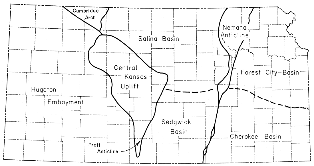
Figure 4—Map of Kansas showing location of petroliferous provinces.
For present purposes, Kansas east of the Nemaha Anticline may be regarded as a unit, but it is well to note that the so-called basins are extremely broad structures and were separate areas of deposition during an extremely brief interval of time in the middle part of the Pennsylvanian period. Consolidated rocks that now are exposed at the surface in the area dip gently westward and constitute the late Paleozoic or early Mesozoic Prairie Plains Monocline (Jewett, 1951, p. 152), which properly should be recognized as extending, under cover, well into northwestern Kansas (Jewett and Merriam, 1959, fig. 10). Gentle folding produced low domes, anticlines, and "noses" that are discernible in outcropping rocks. Most of the "highs" that are measurable in surface rocks are more pronounced in the subsurface, and many serve as oil and gas traps. Some "structural traps" in Pennsylvanian rocks in eastern Kansas have no or very little surface indications; some structures that are traps in pre-Pennsylvanian sediments are completely concealed. Examples of several conditions in which oil and gas occur in eastern Kansas are discussed in detail by Jewett (1954, p. 68).
Some of the gas storage projects in eastern Kansas, described in another part of this report, for example Cities Service Gas Company's McLouth project (Table 2), are in structural traps of the aforementioned kind. It is believed that in almost all counties in the Forest City and Cherokee Basin area structural conditions can be found where porous Pennsylvanian rocks would be suited for gas storage.
Much of the gas and oil that has been discovered in eastern Kansas occurs in "shoestring sands". These are elongate sandstone bodies enclosed by less pervious shale. As hydrocarbon traps these reservoirs may be uninfluenced by localized tectonic conditions and are regarded as "stratigraphic" traps. Parts of some of the elongate sandstone bodies have been arched slightly, however, probably in some cases as a result of differential compaction. Cities Service's Colony project, in Anderson County, utilizes a trap of this kind.
"Shoestring sand" oil and gas pools, at depths ranging to about 3,000 feet, but except in the southwest part much shallower, averaging perhaps about 1,000 feet, are plentiful in the Cherokee Basin and the southern part of the Forest City Basin. Abandoned gas fields lie above many of them. It is reasonable to believe that gas could be stored successfully in many of these sandstone bodies, including some that have yielded gas and oil and some that have been known to contain only water. Rich (1926), Bass (1936), and Jewett (1949, 1954) have described "shoestring" oil and gas reservoirs in eastern Kansas.
In addition to the general conditions described above, some specific structures in eastern Kansas may be mentioned. They are cited here as examples of "highs" that, because of any of several factors such as cultural or other conditions within the areas, mayor may not be suited for gas storage projects. They indicate deviations from the general or regional westward dip of outcropping rocks.
In the vicinity of Kansas City, the Morris Anticline is one of several folds that can be measured in surface rocks in the lower Kansas River Valley. It was described by Jewett and Newell (1935) and by Jewett (1951). Other similar structures occur near Bonner Springs, De Soto, Eudora, and in several other places. Farther south in eastern Kansas there are conspicuous "highs" near Mound City, in Linn County; near Kincaid, in Anderson County; near Humboldt, in Allen County, and near Cherryvale, in Montgomery County. In Cowley and Elk Counties, in the southern part of the Cherokee Basin, several anticlines containing oil and gas pools are typical of localized structural conditions in Pennsylvanian rocks in that part of Kansas. The Elk City field project near Longton is in one of the Elk County structures.
The well-known Nemaha Anticline, whose Precambrian core commonly is called the "Granite Ridge" and somewhat erroneously the "Nemaha Mountains", crosses Kansas from Nemaha County southwestward to Sumner County. Formed by earth movements at about the close of Early Pennsylvanian time, this buried anticline forms the west boundary of the eastern Kansas basins.
As a petroleum-bearing province in Kansas, the Nemaha is an area of slight but somewhat indefinite width. Only a comparatively small number of oil and gas traps have been found along its axis. In the southern part, the great EI Dorado and Augusta oil and gas fields lie partly along the anticlinal axis. Some of the reservoirs are "structural traps" and others, commonly more prolific, are "stratigraphic traps" in beveled sub-Pennsylvanian beds. Farther south in the area, oil and gas is produced from structures more or less parallel to and near the axis and in the anticline itself. Northward from Butler County (EI Dorado and Augusta fields) in the higher parts of the anticline, Pennsylvanian beds are in contact with Precambrian rocks, and only minor amounts of gas have been found in some of the Pennsylvanian sandstones. Several oil fields lie above small anticlines that are near the Nemaha structure on each of its sides. Interesting examples are found in Wabaunsee County. In Riley County oil has been found recently in a sub-Pennsylvanian "Hunton" stratigraphic and structural oil trap on the west flank of the Nemaha structure.
Throughout much of its length the Nemaha Anticline area contains potential gas storage reservoirs. Depths range from a few hundred to 4,000 feet or more. Little research would be required to determine suitable sites for sizable reservoirs. Known higher parts of the anticline, as near Burns, Butler County; Alta Vista, Morris County; Elmdale, Chase County; and the part north of Kansas River, are important potential storage sites.
Stratigraphic and structural conditions in the two areas designated as Salina and Sedgwick Basins are sufficiently different to warrant separation as distinct petroliferous provinces. On a regional structural basis, the two parts, both lying west of the Nemaha Anticline and east of the Central Kansas Uplift (Fig. 4) are properly differentiated, inasmuch as there is distinct thinning of Mississippian rocks in a belt separating them. Geologic conditions in the Sedgwick Basin are more complex than in the Salina Basin.
Lenticular sandstone bodies in the lower part of the Cretaceous section in the northwestern part of the Salina Basin offer possible reservoirs for gas storage, should economic or other conditions warrant storage in this part of the state. Lack of sufficient thickness of overlying rocks might be a handicap in parts of the area.
In both basins the gently westward dipping Pennsylvanian rocks (Jewett and Merriam, 1959, fig. 10) offer numerous potential gas storage reservoirs. Investigations for porous strata in suitable structural positions would be somewhat more difficult in this general area than farther east in the state, but sufficient data seemingly are available for relatively simple studies. Depths to potential reservoirs in Pennsylvanian rocks throughout the two basinal areas range from a few hundred to about 4,500 feet.
The Central Kansas Uplift, nearly in the same area as the older (preMississippian) Ellis Arch, is designated as a petroliferous province in Kansas, and is the state's most prolific oil producing area. Large amounts of gas also have been produced in the area. Oil and gas traps are somewhat complex; there are numerous examples of "stratigraphic" traps of various types below disconformities and elsewhere in the rock section. "Structural" traps are common, especially in Pennsylvanian rocks.
Because of the density of drilling in the Central Kansas area, many data as to porosity and attitude of comparatively shallow rocks are available. Should gas storage in that part of Kansas become desirable, suitable geologic conditions will not be found lacking. Depths to potential reservoirs in Pennsylvanian rocks commonly are slightly in excess of 3,000 feet.
In passing it may be noted that the northern part of the Central Kansas area is in some reports properly designated as Cambridge Arch; the extreme southern part has been called Pratt Anticline (Jewett, 1958, fig. 7).
All Kansas west and south of the Central Kansas Uplift area is designated as a single petroliferous province, the Hugoton Embayment. This large area was basinal both before and after the movements that produced the Central Kansas Uplift and Nemaha Anticline. The very prolific Hugoton gas-producing area is in southwestern Kansas within the larger area.
"Stratigraphic" traps suitable for gas storage are believed to be plentiful, especially in post-Paleozoic rocks in western Kansas at a depth of about 5,000 feet. There are many potential "structural" traps in older and deeper rocks.
It seems probable that it may be desirable to store natural gas in the Hugoton Gas Field. The proved gas productive part of the Hugoton area in Kansas measures about 85 miles north-south and 60 miles east-west. In the Kansas part of the field there are 3,806 producing gas wells. Gas is obtained from porous dolostones and limestones belonging to the Chase Group of early Permian age.
The thickness of the productive zone is about 250 feet; within this thickness of strata there are five main gas "pays" that generally are persistent throughout the field but are not equally productive in different parts of the area. The gas producing beds are reached at depths of about 2,560 to 2,950 feet below the surface, the average being about 2,700 feet.
The Hugoton gas reservoir is a stratigraphic trap that is due to irregular distribution of porosity along the strike (N 20° E) of the gently east dipping Permian beds. As determined from marker beds, the dip is about 15 to 20 feet per mile and it is interrupted locally by minor deformations consisting of easterly pitching anticlines of low relief. There is no surface indication of this structure, inasmuch as the country is entirely covered by Neogene deposits that rest unconformably on Cretaceous or Permian rocks. Conditions favorable to accumulation of gas in the Permian strata are due partly to the regional structure and partly to sedimentation. Marine beds grade laterally westward updip into nonmarine strata consisting of red shale, sandstone, and arkose. The westward limits of gas-productive territory are along the zone of interfingering marine and nonmarine deposits. The chief gas-producing zones are the Fort Riley Limestone (Barneston formation); Towanda Limestone (Doyle Shale); Winfield Limestone; and Krider and Herington Limestones (Nolans formation).
The paragraphs above outline the general structural conditions in: Kansas that are of consequence to underground gas storage projects. More details may be had from numerous publications on individual fields or other areas.
As of January 1, 1960, there were 14 active gas storage projects and 1 pending project in Kansas (Table 2). The Boyer project in Butler County, Colony in Anderson County, Craig in Johnson County, Elk City in Elk and Montgomery Counties, McLouth in Jefferson and Leavenworth Counties, Piqua in Allen and Woodson Counties, and Welda North and Welda South in Anderson County are operated by Cities Service Gas Company. Consolidated Gas Utilities Corporation operates the Collinson Gas Storage project in the Gibson field in Cowley County. Union Gas System, Incorporated, operates five projects, the Buffalo and Fredonia in Wilson County, the Liberty North and Liberty South in Montgomery County, and Longton in Chautauqua County.
Natural gas is stored in Kansas subsurface rocks in depleted sandstone reservoirs, which are overlain and underlain by less pervious materials. Zones for storage include the Iola Limestone, "Severy", "Layton", "Squirrel", "Colony", "Bartlesville", and "Burgess" sandstones (Pennsylvanian) and the "Misener" (Devonian). In the 14 projects in the state, 661 wells are used as injection or producing wells and 68 wells are used for observation. Total storage capacity for natural gas in Kansas is 99,434,882 M cubic feet. Working gas makes up 36,963,657 M cubic feet and cushion gas 62,471,225 M cubic feet.
Table 2—Gas Storage Projects in Kansas
| Project and county | Location | Year field disc. |
No. wells |
No. Obs. wells |
Acres of formation storage |
Acres controlled |
Prod. depth, average (feet) |
Average net sand thickness (feet) |
Date first injection |
Capacity, M c. f. | Zone | |||
|---|---|---|---|---|---|---|---|---|---|---|---|---|---|---|
| Working gas |
Cushion gas** |
Total reservoir |
||||||||||||
| Cities Service Gas Company | ||||||||||||||
| 1. Alden, Rice (Pending) |
1937 | 12 | 0 | 711 | 2,695 | 3,320 | 18 | 5,000,000 | 10,857,469 | 15,857,469 | "Misener" Devonian? |
Max. pressure, 1,120 lb. |
||
| 2. Boyer, Butler |
Parts of sec. 5, 6, 7, 8, 9, 16, 17, 18, 20, T. 26 S., R. 5 E. | 1916 | 14 | 3 | 1,220 | 2,840 | 880 | 10 | 6/27/1929 | 392,279 | 627,588 | 1,019,867 | Wabaunsee (formerly Shawnee) (Penn) | Max. pressure, 250 lb.; withdrawals direct from pipeline—no compressors, |
| 3. Colony, Anderson |
Parts of sec. 31. 32, 33, T. 22 S., R. 19 E; 1, 12, 13, T. 23 S., R. 19 E; 5, 6, 8, T. 23 S., R. 19 E. | 1921 | 82 | 1 | 1,345 | 4,846 | 882 | 47 | 3/31/1953 | 4,148,104 | 5,055,561 | 9,203,665 | "Colony" (Penn) | Max. pressure 280 lb. |
| 4. Craig, Johnson |
Parts of sec. 9, 10, 11, 12, 13, 14, 15, 16, 17, 19, 20, 21, 22, 23, 24, 25, 26, 27, 28, 29, 30, 33, 34, 36, T. 12 S., R. 23 E; 1, 2, 3, 4, 10, 11, 12, 14, 15, T. 13 S., R 23 E. | 1923 | 61 | 24 | 2,360 | 14,967 | 582 | 23 | 5/1931 | 1,557,945 | 4,517,875 | 6,075,820 | "Bush City" (Penn) | Max. pressure, 205 lb. |
| 5. Elk City, Elk and Montgomery |
Parts of sec. 11, 13, 14, 23, 24, 25, 26, 35, 36, T. 31 S., R. 13 E; 19, 30, 31, T. 31 So, R. 14 E; 1, 2, T. 32 So, R. 13 E; 6, T. 32 S., R. 14 E; 15, 22, 27, 34, T. 31 So, R. 13 E; 3. T. 32 S., R. 13 E. | 1918 | 53 | 6 | 2,057 | 8,319 | 1,354 | 30 | 4/22/1958 | 4,500,000 | 15,500,000 | 20.000.000 | "Burgess" (Penn) | Max. pressure, 630 lb. |
| 6. McLouth, Jefferson and Leavenworth |
Parts of sec. 15, 16, 17, 18, 19, 20, 21, 22, 26, 27, 28, 29, 30, 31, 32, 33. 34, 35, 36, T. 9 S., R. 20 E; 25, 36, T. 9 S., R. 19 E; 4, 5, 6, 7, 8, 9, T. 10 S., R. 21 E; 1, 2, 3, 4, 5, 6, 7, 8, 9, 10, 11, 12, 17, 18, 19, 20, T. 10 S., R. 20 E. | 1940 | 114 | 6 | 5,390 | 22,725 | 1,427 | 18.4 | 4/27/1954 | 5,212,337 | 7,701,420 | 12,913,757 | "Bartlesville" (Penn) | Max. pressure, 500 lb. |
| 7. Piqua, Allen and Woodson |
Parts of sec. 34, 35, 36, T. 34 S., R. 17 E; 1, 2, 3, 4, 9, 10, 11, T. 25 S., R. 17 E. | 1922 | 30 | 8 | 1,090 | 4,390 | 898 | 20.4 | 8/8/1955 | 1,551,042 | 1,679,430 | 3,230,472 | "Colony" (Penn) | Max. pressure 295 lb.; withdrawals, direct from pipeline—no compressors. |
| 8. North Welda, Anderson |
Parts of sec. 16, 17, 18, 20, 21, 22, 23, 25. 26, 27, 28, 29, 34, 35, T. 21 S., R. 19 E. | 1921 | 75 | 6 | 2,125 | 6,006 | 893 | 29 | 5/22/1934 | 4,521,646 | 5,500,000 | 10,021,646 | "Colony" (Penn) | Max. pressure 280 lb., |
| 9. South Welda, Anderson |
Parts of sec. 2, 3, 4, 9, 10, 11, 14, 15, 16, 21, 22, 23, 26. 27, 28, T. 22 S., R. 19 E. | 1921 | 105 | 6 | 2,528 | 7,595 | 921 | 32 | 7/12/1937 | 5,313,617 | 6,475,569 | 11,789,186 | "Colony" (Penn) | Max. pressure, 280 lb. |
| Consolidated Gas Utilities Corporation | ||||||||||||||
| 10. Gibson (Collinson), Cowley |
Parts of sec. 29, T. 34 S., R. 3 E. | 2 | 0 | 240 | 1,435 | 18 | 10/1947 | 647,270 | 425,730 | 1,073,000 | Severy Sh. (Penn) | |||
| Union Gas System, Inc. | ||||||||||||||
| 11. Buffalo, Wilson |
Parts of sec. 6, 7, 8, 17, 18, T. 27 S., R. 16 E. | 1916 | 26 | 1 | 1,708 | 1,708 | 182 | 15 | 5/1942 | 2,524,175* | 4,130,583 | 8,250,000 | Iola Ls. (Penn) | Injection from high-pressure transmission lines |
| 12. Fredonia, Wilson |
Parts of sec. 8, 9, 16, 17, 20, T. 29 S., R. 15 E. | 1915 | 17 | 1 | 1,980 | 1,980 | 248 | 25 | 8/1949 | Kansas City "Layton" (Penn) | (Cottage Grove or Noxie) Injection from high-pressure line | |||
| 13. Liberty South, Montgomery |
Parts of sec. 3, 4, 5, 8, 9, T. 34 S., R. 17 E. | 1914 | 18 | 3 | 1,565 | 1,565 | 428 | 35 | 6/1948 | "Squirrel" (Penn) | From high-pressure line | |||
| 14. Liberty North, Montgomery |
Parts of sec. 21, 22, 27, 28, 32, 33, 34, T. 33 S., R. 17 E. | 1914 | 19 | 2 | 3,002 | 3,002 | 428 | 35 | 4/1954 | "Squirrel" (Penn) | From high-pressure line | |||
| 15. Longton, Chautauqua |
Parts of sec. 2, 3, 4, 9, 10, T. 32 S., R. 12 E. | 1916 | 33 | 1 | 3,280 | 3,280 | 659 | 30 | 3/1940 | "Layton" (Penn) | From high-pressure line | |||
| * Plus unused capacity 1,595,242 M c. f. as of 12/22/1959 **Minimum retained for pressure maintenance. |
||||||||||||||
In almost all parts of Kansas, geologic conditions are favorable for economical storage of natural gas in porous rocks. Fortunately near the centers of larger population and industries, Wichita (Sedgwick County, population 332,092*), Greater Kansas City (Wyandotte County, population 184,357*; Johnson County, population 141,694*), and Topeka (Shawnee County, population 144,357*), natural reservoirs at comparatively shallow depths are believed to be sufficient for storing gas in as large quantities as may be desired in the foreseeable future. (* Population (unofficial) from 1960 Census.)
In other parts of Kansas the porosity, permeability, and attitude of rocks are such that in almost every county, gas storage projects may be initiated, it is believed, after not extensive investigation of geologic conditions. Foregoing parts of this report indicate depths and other conditions in which gas can be stored in natural geologic "traps".
Heretofore attention has been directed principally to geologic conditions that are the same as those in which gas now occurs. It is evident, however, that gas can be stored in artificial reservoirs. At the present time liquid hydrocarbons, principally liquified petroleum gas, are stored in Kansas in cavities artificially dissolved in Permian saltstone in the central and western part of the state (Jewett, 1955; 1956). There seem to be no reasons that similar "salt jugs" could not be utilized for storing gas. LPG storage projects are in operation in McPherson, Reno, Grant, and Kingman Counties. Depths below the surface range from about 400 to 1,000 feet. A more or less typical cavity is about 200 feet high and 30 feet in diameter, but some "jugs" are 40 feet high and 100 feet in diameter.
Extensive space in existing salt mines in several places in central and southern Kansas offers possibilities for gas storage. In Rice, Ellsworth, Reno, and Kingman Counties, salt has been mined by the room-and-pillar method as well as hydraulically. Room-and-pillar mining has created a great amount of possible storage space, most of which is not now utilized. It is estimated that in eight mines there is total space of almost 400 million cubic feet. Sealing off portions of these mines would be comparatively easy. The use of huge plastic bags is worthy of consideration.
Abernathy, G. E. (1943) Deep water well at the Jayhawk Ordnance Works in Cherokee County, Kansas: Kansas Geol. Survey Bull. 47, pt. 3, p. 77-112. [available online]
Bass, N. W. (1936) Origin of the shoestring sands of Greenwood and Butler Counties, Kansas: Kansas Geol. Survey Bull. 23, p. 1-135. [available online]
Bureau of Mines, United States Dept. Interior (1959) 1958 Minerals Yearbook, v. 2, Fuels, p. 322-324.
Farquhar, O. C. (1957) The Precambrian rocks of Kansas: Kansas Geol. Survey Bull. 127, pt. 3, p. 49-122. [available online]
Federal Power Commission (1959), Major natural gas pipelines as of December 31, 1958, (Map) F.P.C. M-53.
Frye, J. C. (1949) Ground water in southwestern Kansas: Kansas Geol. Survey Misc. Publ., p. 1-24.
Frye, J. C., and Leonard, A. B. (1952) Pleistocene geology of Kansas: Kansas Geol. Survey Bull. 99, p. 1-230. [available online]
Frye, J. C., Leonard, A. B., and Swineford, Ada (1956) Stratigraphy of the Ogallala Formation (Neogene) of northern Kansas: Kansas Geol. Survey Bull. 118, p. 1-89. [available online]
Goebel, E. D., and others (1960) Oil and gas developments in Kansas during 1959: Kansas Geol. Survey Bull. 147, p. 1-254.
Jewett, J. M. (1949) Oil and gas in eastern Kansas: Kansas GeoL Survey Bull. 77, p. 1-308.
Jewett, J. M. (1951) Geologic structures in Kansas: Kansas Geol. Survey Bull, 90, pt. 6, p. 105-172. [available online]
Jewett, J. M. (1954) Oil and gas in eastern Kansas: Kansas Geol. Survey Bull. 104, p. 1-397.
Jewett, J. M. (1954a) Kansas oil potential high after 100 years: Petroleum Engineer, v. 26, no. 6, sec. B, p. 25-36.
Jewett, J. M. (1955) LPG storage in Kansas salt beds: Guidebook 18th Field Conf., Kansas Geol. Soc., Wichita, p. 91-94.
Jewett, J. M. (1956) Kansas; in, Underground storage of liquid hydrocarbons in the United States: Interstate Oil Compact Commission, Oklahoma City, p. 26-34.
Jewett, J. M. (1958) Subsurface geology of Kansas and its relation to accumulation and production of oil and gas: Interstate Oil Compact Commission, Oil and Gas Compact Bull., v. 17, no. 2, p. 35-44.
Jewett, J. M. (1959) Graphic column and classification of rocks in Kansas: Kansas Geol, Survey, (chart), 25" x 38".
Jewett, J. M. (1960) How major geologic features developed in Kansas; World Oil, Jan., p. 119-124, 149.
Jewett, J. M., and Abernathy, G. E. (1945) Oil and gas in eastern Kansas: Kansas Geol. Survey Bull. 57, p. 1-244.
Jewett, J. M., and Merriam, D. F. (1959) Geologic framework of Kansas—a review for geophysicists; in, Symposium on geophysics in Kansas: Kansas Geol. Survey Bull. 137, p. 9-52. [available online]
Jewett, J. M., and Newell, N. D. (1935) Geology of Wyandotte County, Kansas: Kansas Geol. Survey Bull. 21, pt. 2, p. 151-162. [available online]
Jewett, J. M., and Schoewe, W. H. (1942) Kansas mineral resources for wartime industries: Kansas Geol. Survey Bull. 41, pt. 3, p. 69-180. [available online]
Jewett, J. M., and Smith, R. K. (1949) Oil-bearing rocks in Kansas: Mines Magazine, v. 39, no. 12, p. 85-90.
Keroher, R. P., and Kirby, J. J. (1948) Upper Cambrian and Lower Ordovician rocks in Kansas: Kansas Geol. Survey Bull. 72, p. 1-140. [available online]
Kulstad, Robert O. (1960) Hutchinson saltstone, Permian, Kansas: Kansas Geol. Survey, in preparation.
Landes, K. K., and Keroher, R. P. (1938) Geology and oil and gas resources of Rush County, Kansas: Kansas Geol. Survey Min. Res. Circ. 4, p. 1-31. [available online]
Latta, B. F. (1946) Cretaceous stratigraphy of the Belvidere area, Kiowa County, Kansas: Kansas Geol. Survey Bull. 64, pt. 6, p. 217-260. [available online]
Leatherock, Constance (1945) The correlation of rocks of Simpson age in north-central Kansas with the St. Peter Sandstone and associated rocks in northwestern Missouri: Kansas Geol. Survey Bull, 60, pt. 1, p. 1-16. [available online]
Lee, Wallace (1939) Relation of thickness of Mississippian limestone in central and eastern Kansas to oil and gas deposits: Kansas Geol. Survey Bull, 26, p. 1-42. [available online]
Lee, Wallace (1940) Subsurface Mississippian rocks of Kansas: Kansas Geol. Survey Bull. 33, p. 1-114. [available online]
Lee, Wallace (1949) Subsurface geologic cross section from Barber County to Saline County, Kansas: Kansas Geol. Survey, Oil and Gas Inves. 8, cross sec., p. 1-16. [available online]
Lee, Wallace (1953) Subsurface geologic cross section from Meade County to Smith County, Kansas: Kansas Geol. Survey, Oil and Gas Inves. 9, cross sec., p. 1-23. [available online]
Lee, Wallace (1956) Stratigraphy and structural development of the Salina Basin Area: Kansas Geol. Survey Bull. 121, p. 1-167. [available online]
Lee, Wallace, Leatherock, Constance, and Botinelly, Theodore (1948) The stratigraphy and structural development of the Salina Basin of Kansas: Kansas Geol. Survey Bull. 74, p. 1-155. [available online]
Lee, Wallace, and others (1946) Structural development of the Forest City Basin of Missouri, Kansas, Iowa, and Nebraska: U. S. Geol. Survey Oil and Gas Inves., Prelim. Map 48, sheets 1-7. [available online]
McLaughlin, T. G. (1942) Geology and ground-water resources of Morton County, Kansas: Kansas Geol. Survey Bull. 40, p. 1-126. [available online]
Moore, R. C., Frye, J. C., and Jewett, J. M. (1944) Tabular description of outcropping rocks in Kansas: Kansas Geol. Survey Bull. 52, pt. 4, p. 137-212. [available online]
Moore, R. C., and Jewett, J. M. (1942) Oil and gas fields in Kansas: Mines Magazine, v. 32, no. 10, p. 481-488, 515-520, 526, 538, 560.
Moore, R. C., and others (1951) The Kansas rock column: Kansas Geol. Survey Bull. 89, p. 1-132. [available online]
Moore, R. C., and others (1951a) Geology, mineral resources, and groundwater resources of Chase County, Kansas: Kansas Geol. Survey, v. 11, p. 1-49. [available online]
O'Connor, H. G., Goebel, E. D., and Plummer, Norman (1953) Geology, mineral resources, and groundwater resources of Lyon County, Kansas: Kansas Geol. Survey, v. 12, p. 1-59. [available online]
Plummer, Norman, and Romary, J. F. (1942) Stratigraphy of the pre-Greenhorn Cretaceous beds of Kansas: Kansas Geol. Survey Bull. 41, pt. 9, p. 313-348. [available online]
Rich, J. L. (1926) Further observations on shoestring oil pools in eastern Kansas: Am. Assoc. Petroleum Geologists Bull., v. 10, p. 568-580.
Smith, H. T. U. (1940) Geological studies in southwestern Kansas: Kansas Geol. Survey Bull. 34, p. 1-244. [available online]
Swineford, Ada (1955) Petrography of upper Permian rocks in south-central Kansas: Kansas Geol. Survey Bull. 111, p. 1-179. [available online]
Kansas Geological Survey
Placed on web Oct. 3, 2018; originally published in 1960.
Comments to webadmin@kgs.ku.edu
The URL for this page is http://www.kgs.ku.edu/Publications/Bulletins/OGI21/index.html