Kansas Geological Survey, OGI 8
Originally published in 1949 as Kansas Geological Survey Oil and Gas Investigations 8. This is, in general, the original text as published. The information has not been updated. An Acrobat PDF version (32.5 MB) is also available.
The cross section (No. 8) herein presented was prepared as a cooperative project between the U. S. Geological Survey and the State Geological Survey of Kansas. It extends from sec. 35, T. 34 S., R. 11 W., in Barber County near the Oklahoma border, northeast to the central part of the Salina basin in sec. 2, T. 15 S., R. 1 W., in Saline County and shows the relations in the subsurface from southwest to northeast across the Chautauqua-Central Kansas arch.
The principal features of the subsurface stratigraphy of the region have been well established through years of work by petroleum geologists who have examined samples from thousands of wells and outcrops. Many of the smaller units of the Permian and Pennsylvanian Systems described on the surface in central and eastern Kansas, and most of the major subdivisions of the Mississippian, Devonian, Silurian, Ordovician, and Cambrian Systems recognized in Missouri, Iowa, and Oklahoma have been identified in the wells, and their terminology is generally agreed upon by Kansas petroleum geologists. The stratigraphic classification of the units recognized and traced in this report follows the usage currently adopted by the State Geological Survey of Kansas.
Many of the wells in the area traversed by the cross section were drilled before rotary tools so generally superseded cable tools. In consequence, there are some complete sets of samples from wells drilled by cable tools and a good many drillers' logs that show the stratigraphic sequence with considerable detail. Five of the 28 logs shown in the cross section (nos. 8, 11, 14, 23, and 28) are sample logs of wells drilled by cable tools. One well (no. 25) was drilled to the top of the Mississippian by rotary tools and completed in the Arbuckle limestone by cable tools. Nine of the logs (nos. 1, 2, 3, 5, 7, 13, 16, 20, and 27) are sample logs of wells drilled entirely by rotary tools. Well no. 8 was drilled by cable. tools but samples were not available above 158 feet, where the drillers log was used. The remaining 13 logs are good drillers' logs of wells drilled by cable tools. Logs 4 and 15 are sample logs in the prePennsylvanian rocks. The drillers' logs are interspersed with sample logs with which they have been compared and correlated.
Many errors inherent in the sampling of wells interfere with the correct interpretation of local structure and lithology on the cross section. The tops of formations, as determined from samples from deep wells drilled by rotary tools, log below the actual cutting depth. Schlumberger logs, which are available only for wells 2 and 3 were used to check the corresponding sample logs. Corresponding horizons in the lower parts of these wells were recorded from 10 to 30 feet lower in the sample logs. Depths determined from samples of rotary wells and of wells drilled by cable tools are thus not comparable in detailed structural studies. The alternate use of logs of wells drilled by the two methods introduces unreal local differences in depth of a minor character. Some variations in the recorded thickness and lithologic character of the formations are due to the mixture of samples, especially in rotary wells, in which the thickness of limestone units is likely to be exaggerated. Such errors, however, are rarely of a magnitude to affect seriously the interpretation of regional structural relations or regional lithologic changes. A factor which does interfere with the determination of structure by cross sections is their two-dimensional character. Any departure of a cross section from a straight line introduces the effect of the third dimension. If the departure is basin ward, the cross section will suggest a syncline not actually present. If the deviation of a cross section from a straight line is up dip, the cross section will falsely suggest anticlinal conditions.
The seeming increase or decrease in the thickness or the disappearance of impure limestone beds in calcareous shale formations depends in part on the amount of calcareous material present in the shale. An impure limestone may be reported as limestone in one well and as shale in another where the calcareous content is less conspicuous.
Figure 1—Map showing principal structural features of Kansas in relation to cross section A-A'. The Chautauqua arch, shown by the pre-Chattanooga outcrop of St. Peter sandstone; active from St. Peter through Chattanooga time. The North Kansas basin, outlined by 1,000-foot thickness contour of rocks between the St. Peter sandstone and the Mississippian limestones; contemporaneous with Chautauqua arch. The Nemaha anticline indicated by anticlinal axis; active from end of Mississippian time through early Permian time. Voshell and Halstead-Graber anticlines, indicated by anticlinal axes, and other anticlines parallel to Nemaha anticline; contemporaneous with Nemaha anticline. The Central Kansas uplift outlined by pre-Pennsylvanian margin of Mississippian limestones (southwestern margin after Claire, 1948); slight movement before Mississippian time, major activity from end of Mississippian time through early Permian time. Salina basin shown by synclinal axis; active from end of Mississippian time through early Permian. Hugoton embayment, initiated in pre-Mississippian time, active from end of Mississippian time to Kansas City time, revived in late Permian time, The Forest City and Cherokee basins east of Nemaha anticline are not shown.

On the line of the cross section, Quaternary clay, sand, and gravel overlie consolidated Permian rocks northeast of well 20 in southeastern McPherson County. Dakota rocks are reported to cap the divide between wells 18 and 23 but the Dakota was not recognized in the logs of the wells in that area shown in the cross section. Unconsolidated Tertiary as well as Quaternary rocks overlie the Permian southwest of well 20. The maximum thickness of unconsolidated rocks of Quaternary and Tertiary age observed in the wells is about 160 feet in wells 13 and 14.
The rocks of the Leonardian Series were beveled on the line of the cross section toward the northeast by erosion that followed Permian time. Much later, after the Cretaceous rocks were deposited and had been removed by erosion, erosion of the Permian rocks was renewed from time to time. Although the Permian rocks are generally covered by Tertiary or Quaternary rocks they are still being actively eroded in many places. Only the Nippewalla and the Sumner groups of the Leonardian are represented on the cross section.
Nippewalla group
Nippewalla rocks, 450 to 100 feet thick, occur on the line of the cross section only southwest of well 8 in Kingman County. They include alternating sandstone and red shale of undifferentiated Salt Plain and upper Harper age, as much as 290 feet thick, and red shale of lower Harper age approximately 160 feet thick in well 3. The base of the sequence was identified only from the drillers log of well 8, but it was recognized, though with some doubt, from the samples of well 7.
Sumner group
The Sumner group in descending sequence comprises the Stone Corral dolomite, the Ninnescah shale, and the Wellington formation. Rocks of the group are 1,480 feet thick in well 1 in Barber County. The formations become thinner toward the northeast on the line of the cross section.
The Stone Corral dolomite in outcrops consists of a variable sequence of dolomite, limestone, anhydrite, and shale. It is reported as 50 feet thick in the subsurface in wells west of the cross section, but it was not identified in any of the sample logs, although it is probably present throughout the area southwest of Kingman County. In two logs (7 and 8) drillers report "breaks" in the red shale sequence which are tentatively believed to represent the Stone Corral dolomite.
In the absence of the Stone Corral the point of separation between the Harper formation and the Ninnescah, which is entirely similar, is indeterminate and the thicknesses of each are only estimates. The assumed thickness of the Ninnescah ranges from 500 feet in well 1 to 320 feet in well 9.
The Wellington formation, 980 to 750 feet thick, consists of an upper dark shale member, a middle salt member, and a lower member (the "Pearl shale" of the outcrops) which in the subsurface consists dominantly of anhydrite interstratified with dark shale. The upper member is 150 feet thick in well 3, but it ordinarily ranges in thickness somewhat irregularly from 350 feet in well 1 to 260 feet-in well 10. The Hutchinson salt member, 430 to 270 feet thick, is interlaminated with thin gypsum partings. In rotary drilling the salt is dissolved and the salt member is recognized by the presence of broken and irregular flakes of gypsum and molds of salt crystals. Northeast of well 11, ground water has dissolved the salt and allowed the overlying dark shale member to settle upon the residual debris. The basal or "Pearl shale" member, 200 to 170 feet thick, consists mainly of anhydrite interbedded with discontinuous dolomite deposits and thick dark-gray shale beds which cannot be traced from well to well. One of the dolomite beds, the Hollenberg dolomite, can generally be identified near the base of the formation.
Chase group
The Chase group, 350 to 370 feet thick, consists of alternating formations of limestone and shale. The limestone formations, in descending order, are the Nolans, Winfield, Barneston, and Wreford, all except the Nolans characteristically cherty. The Doyle shale, between the Winfield and the Barneston, includes the Towanda limestone member. The Matfield shale, between the Barneston and the Wreford, includes the Kinney limestone member.
The Nolans limestone at the top of the group ranges in thickness from 25 to 70 feet. The abrupt changes in its thickness, compared with the relative regularity of the other limestone formations of the group, suggest the possibility of a disconformity at its top, although this suggestion is not supported by the regularity of the overall thickness of the group. Unlike the other limestone formations of the group, the Nolans in the subsurface generally consists mainly of sucrose dolomite although some limestone is present in most samples. At wells 1, 23, and 28, the formation consists entirely of limestone. The formation is cherty in wells 3 and 11 and probably locally elsewhere. Interbedded shale occurs in the formation but the named members distinguished in the outcrops cannot be differentiated in the subsurface.
The thickness of the Winfield limestone increases irregularly from 35 feet in the northeast to 60 feet near the southwest end of the cross section. The Winfield consists mainly of limestone but some dolomite was observed in a few samples. The samples from some wells indicate the presence of shale in the middle part of the formation, and in well 1 the shale is red. Chert is present in varying amount in both the upper and lower parts of the formation and increases in abundance toward the southwest.
The Towanda limestone member of the Doyle formation is 10 to 35 feet thick, impure, and owes its extremely irregular thickness to variations in the amount of calcareous material. deposited in the Doyle shale. As a result the Doyle shale is reported in some drillers logs as all limestone and in others as all shale. Near the Oklahoma border, where the Towanda seems to be more regular than it is farther to the northeast, the observed thickness ranges from 10 to 15 feet.
The Barneston limestone, 85 to 100 feet thick, consists of the noncherty Fort Riley limestone member at the top and the very cherty Florence limestone member at the base. These members are separated in the outcrops by a thin shale member, but this is rarely recognized in the subsurface . The position of the Barneston above the red beds that are present almost everywhere at the top of the underlying Matfield shale aids in identifying the Barneston. The Fort Riley limestone member contains the youngest fusulines in Kansas.
The Kinney limestone member of the Matfield shale, like the Towanda, is impure and irregular in thickness, owing to the variability in its carbonate content. It thickens irregularly from 15 feet in well 28 to 3'5 feet in well 6. It was not recognized in the Matfield. southwest of well 6.
The Wreford limestone, 30 to 60 feet thick; is conspicuously cherty in most wells although the amount of chert is variable. The Wreford limestone includes some shale whose thickness and position are obscure in the subsurface. The thickness of the Wreford remains regular at about 60 feet, northeast of well 8, but southwest of well 8 it becomes thinner and the shales above and below it become thicker. No evidence of unconformity at the base of the Wreford was noted on the line of this cross section.
Council Grove group
The Council Grove group consists of alternating formations of limestone and shale. Its thickness increases with only slight irregularity from 285 feet in well 28 to 425 feet in well 1. Southwest of well 4, the group thickens rapidly. It includes in descending order the following limestone formations separated by shale formations: Funston, Crouse, Bader, Beattie, Grenola, Red Eagle, and Foraker. Most of the interstratified shale formations either include or are composed of red and variegated shale, which more or less strongly characterize the group lithologically.
Most of the limestone formations are thin-bedded, impure, and interbedded with shale. All the formations of this group can be recognized in some wells, but the varying amount of shale included with the limestones and the variable character and impurity of the limestones prevent identification in others.
The Funston limestone, the top of which is about 15 feet below the base of the Wreford, is 10 to 20 feet thick. In some drillers logs it seems to coalesce with the Crouse limestone which in the subsurface is 10 to 20 feet thick and normally 10 to 15 feet below the Funston. The Bader limestone although generally represented by 10 to 25 feet of limestone seems to be 40 feet thick in well 8. In wells 2 and 3 it coalesces with the Beattie limestone from which it is. ordinarily separated by 10 to 15 feet of shale. The Cottonwood limestone, the basal member of the Beattie, is a massive limestone with abundant slender fusulines. The Beattie is underlain by the Eskridge shale which is red or partly red throughout the greater part of Kansas.
The Grenola limestone underlies the Eskridge. Its thickness is nearly constant, 25 to 35 feet, from well 5 to well 28, but increases to 60 feet in well 1. Its upper member, the Neva limestone, is generally massive. The massive Cottonwood limestone, separated from the Neva limestone by the red shales of the Eskridge, provides an easily recognized sequence in sample logs and in most drillers logs. In wells 1 and 2, however, the Eskridge has lost its characteristic red color. The Grenola limestone south of well 13 becomes algal and in wells 7 and 8 includes oolitic beds.
The Red Eagle limestone is present only intermittently. Where present it ranges from 10 to 20 feet in thickness. Although facies changes from limestone to shale may account for part of the seeming discontinuity of the Red Eagle limestone, its relations to the underlying and overlying formations suggest a disconformity above it. The Foraker limestone is generally recognized in sample and drillers logs but, as it includes shale beds and platy impure limestone, its limits are obscure in many wells. It contains abundant fusulines, but as some of the shales and thin impure limestones of the underlying Admire group also contain abundant fusulines, this characteristic cannot be relied upon to identify the Foraker. The upper beds of the Foraker in wells 8 and 25 are oolitic. Chert occurs in the Foraker in well 13 and abundant ostracodes were observed at its base in well 3.
Admire group
The Admire group includes the beds from the base of the Foraker to the top of the Pennsylvanian rocks from which it is separated by a low angular unconformity. The eroded surface upon which the Permian rocks were deposited has a local relief of more than 120 feet in outcrops; As a result, the thickness of the group, 175 to 300 feet, varies widely within short distances. The sequence consists chiefly of shale and sandy shale, but includes some lenticular sandstone and some relatively thin beds of impure fossiliferous limestones. The Towle shale is the lowest formation of the group. Where the Towle overlies channels or topographically low areas, its basal member is the Indian Cave sandstone. Where the Indian Cave sandstone is absent, the contact of the Towle shale with the Pennsylvanian rocks is obscure, and the base of the Admire group has been placed above the highest identifiable limestone of the underlying Wabaunsee group. This placement of the contact is at best an approximation, because the thin limestones of the upper Wabaunsee group are not everywhere clearly revealed by the samples. The contact of the Permian and Pennsylvanian rocks as shown is thus representative of the known character of the contact rather than factual for each well.
The Houchen Creek, Five Point, Falls City, and Aspinwall limestones are the named limestone formations of the group. All are relatively thin and interbedded with shale. They display no very striking lithologic features and have been only tentatively identified by their relative positions in the section. Discontinuous limestone beds perhaps representing calcareous shale beds are interstratified in some localities between the named limestone formations.
The thickness of the Pennsylvanian rocks ranges from 1,520 feet in well 28 to 1,890 feet in well 1. Part of the variation in thickness is due to the local relief of the erosional surface at its top, but there is a gradual increase of the over-all thickness toward the southwest.
Wabaunsee group
The thickness of the Wabaunsee group, 400 to 500 feet, varies considerably from well to well on account of the pronounced unconformity at its top and the minor disconformity at the base where the underlying Topeka limestone of the Shawnee group was locally reduced in thickness or removed by erosion. Many of the limestone formations, especially in the upper part of the Wabaunsee group, like those of the Admire group, are discontinuous or seem to be discontinuous because they are thin or impure. The following formations of the Wabaunsee group listed in descending order consist chiefly of limestones: Brownville, Caneyville, Jim Creek, Grandhaven, Dover, Maple Hill, Tarkio, Elmont, Reading, Wakarusa, Burlingame, Rulo, Happy Hollow, and Howard limestones. These formations are separated from one another by shale and sandy shale formations, some of which include discontinuous bodies of sandstone.
The Brownville limestone probably is not present in any of the wells because of the prePermian erosion of the Wabaunsee group. The Caneyville limestone, an alternating sequence of thin limestones and shales, has not been removed by erosion from higher parts of the pre-Permian surface and is present in wells 25, 26, 1, 2, and 4 to 8. The thin Jim Creek limestone, although its outcrop has been traced across Kansas, was not identified in the subsurface. The Grandhaven limestone is not present in the cross section unless represented by a part of the limestone sequence referred to the Caneyville.
The Tarkio limestone, which is characterized by an abundance of large fusulines, and the Dover limestone are generally present, but the thin intervening Maple Hill limestone was not recognized. The Dover and Tarkio are represented together in the cuttings from some wells. The Elmont and Reading are similarly combined in the samples from some wells. Persistent thin red shales between the Reading and the Wakarusa and between the Wakarusa and the Burlingame are helpful in identifying these formations. The Rulo, which is generally thin, was not identified in all wells and may be discontinuous.
The Happy Hollow limestone is only from 1 to 8 feet thick in the outcrops of eastern Kansas, but in the subsurface it ranges from 15 to 40 feet in thickness. It is thicker toward the southwest where, in wells 2 and 3, the Happy Hollow coalesces with the Howard into a single limestone 50 to 60 feet thick. The Happy Hollow is oolitic in well 23. In wells 26 and 28 sandstone and sandy shale of the overlying Cedar Vale shale formation replace the Happy Hollow and rest on the underlying White Cloud shale. The Howard as revealed by samples from wells drilled by cable tools reaches 20 feet in thickness, but where it can be distinguished from the Happy Hollow in samples from rotary wells, it seems to be about 35 feet thick. Shale is present in the cuttings from the Howard limestone but the shale members of the outcrops cannot be differentiated in the subsurface.
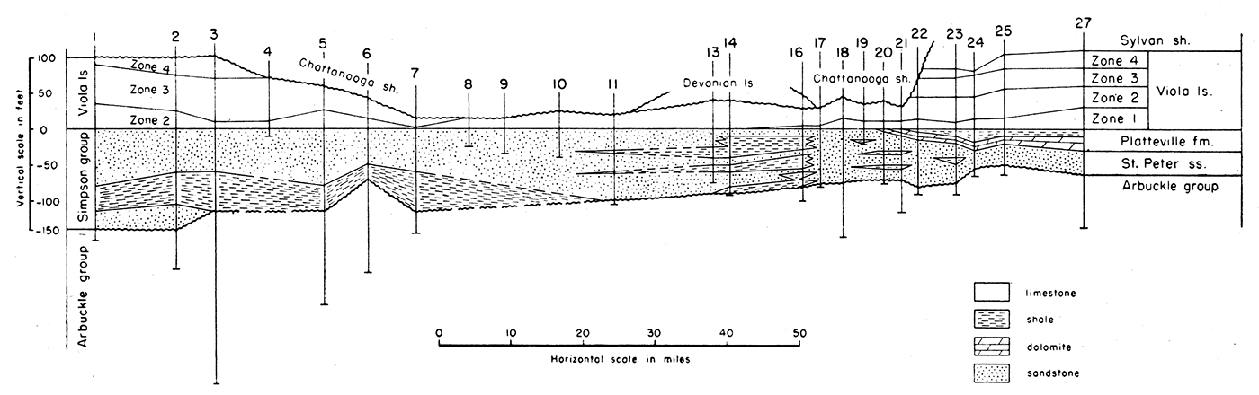
Figure 2—Cross section showing the details of the Simpson group and the Viola limestone and dolomite.
The Severy shale, the basal formation of the Wabaunsee group, consists of clay shale and some platy to massive sandstone. A dis conformity has been reported in the lower part in some outcrops (Moore, Frye, and Jewett, 1944, p. 176). The underlying Topeka limestone of the Shawnee group was removed in some subsurface areas during this or another period of erosion. It is not present in well 3 and is reduced in thickness in some other wells.
Shawnee group
The Shawnee group, 315 to 440 feet thick, consists of limestone, shale, and some sandstone. The group is divided into four thick limestone formations which include shale members. They alternate with thick shale formations, some of which include thin limestone beds. The thickness of the group increases regularly toward the southwest but this increase is only a component of a greater regional increase of thickness toward the south-southeast (Lee, Leatherock, and Botinelly, 1948).
The following formations composed dominantly of limestone are named in descending order: Topeka, Deer Creek, Lecompton, and Oread limestones. The Clay Creek limestone member of the Kanwaka shale, which lies between the Lecompton and the Oread limestones, attains a greater thickness in the subsurface than in the outcrops.
The Topeka limestone, 10 to 70 feet thick, as represented in well cuttings, is variable in character as well as in thickness. It is cherty in wells 28 and 23. Samples from well 8 reveal the shale members of the outcrops, but these are obscure in most wells. The thickness of the Topeka decreases from 65 feet in well 28 in the Salina basin to 40 feet in well 11, and increases again to 70 feet in well 16. These changes in thickness represent differential structural movements of the Salina basin syncline and the structural divide that separates it from the deeper basin farther south. The thickness of the Topeka decreases to 35 feet in well 2 and to 10 feet in well 1 as a result of the wedging out of the limestone members or their lateral gradation into shale toward the source of clastic sediments.
The Deer Creek limestone, 40 to 85 feet thick, is separated from the Topeka by the Calhoun shale. The Deer Creek in the outcrop consists of three limestone and two shale members. These members can rarely be recognized in the samples. The thickness of the formation increases from 40 feet in well 28 in the Salina basin to 85 feet in well 11. Farther southwest, the thickness probably decreases slightly although the limits of the formation as determined from rotary samples are obscure. In well 2 the greater part of the formation consists of shale, and in well 1, the formation cannot be recognized in the long shale sequence which constitutes the greater part of the Shawnee group in Barber County.
The Lecompton limestone, 25 to 50 feet thick, is separated from the Deer Creek by the Tecumseh shale, which is locally sandy and cuts out the Lecompton in well 16 and in some other wells in the same general area. Toward the southwest the Lecompton limestone in wells 2 and 3 consists largely of shale which separates an upper and lower limestone member. In well 1, the upper member has disappeared possibly by wedging out but probably by lateral gradation into shale.
The Clay Creek limestone member in outcrops occurs near the middle of the Kanwaka shale and averages only about 2 feet in thickness, although some of the adjacent shales are calcareous. In the subsurface on the line of the cross section the Clay Creek is thicker and makes up most of the Kanwaka. It is separated from the overlying Lecompton and the underlying Oread by shale beds rarely more than 10 feet thick. In most wells especially rotary wells, shale beds, if present, are not identified and the Clay Creek commonly is included as a part of an unbroken limestone sequence including the Lecompton and Oread limestones. Southward toward the source of sediments, the limestone grades laterally into shale. Only 10 feet of limestone represents the Clay Creek in well 3. It is not present in wells 1 and 2.
Figure 3—Skeletonized cross sections on the line of the large cross section showing the development of structure by correlation of logs on successive beveled or depositional surfaces. A shows the attitude of the older rocks at the end of Simpson time. B shows the attitude of the Chattanooga shale and older rocks before the deposition of the Mississippian limestones; the dashed lines show the relation of Devonian and Silurian rocks before the erosion of the pre-Chattanooga valley. C shows the attitude of the pre-Pennsylvanian rocks after post-Mississippian beveling, D shows the attitude of the older rocks at the beginning of Kansas City time. E shows the attitude of the rocks at the beginning of Barneston time, F shows the present attitude of the rocks. [A larger PDF version of this figure is available, 5.1 MB.]
The Oread limestone in the outcrops consists of four limestone and three shale members, but these members cannot be identified in the subsurface. The thickness decreases from 100 feet in well 28 in the Salina basin to 75 feet in well 23 on the structural divide that borders the Salina basin on the south. The thickness increases in the structural basin farther south. The interval between the Clay Creek limestone member of the Kanwaka shale and the Oread remains fairly constant, 5 to 10 feet, in the most reliable logs, as far southwest as well 11. Beyond this point, the thickness of the shale increases at the expense of the Oread limestone, which breaks up into an alternating sequence of limestone and shale beds. In well 1, only a single bed of limestone about 10 feet thick survives the lateral transition of limestone to shale.
Douglas group
The Douglas group, 135 to 210 feet thick, is composed of sandstone, shale, and a few thin limestone beds. On the line of the cross section it rests disconformably on the Lansing group of the underlying Missourian Series. The Pedee group is the youngest group of the Missourian Series, but it was generally eroded locally in the subsurface during the hiatus between the Virgilian and the Missourian Series.
The disconformity at the base of the Douglas group accounts for the compensating variations in the thickness of the Douglas and Lansing groups. The sandstone shown in nearly every well in the cross section is the Ireland sandstone which lies above the Haskell limestone in the lower part of the Douglas group. The Haskell limestone, 5 to 15 feet thick, is about 35 feet above the top of the Lansing on the northeastern end of the cross section but seemingly is absent southwest of well 11.
The Missourian Series comprises the Pedee, Lansing, Kansas City, and Pleasanton groups. There is nothing to suggest that the Pedee group is represented on the line of the cross section.
Lansing and Kansas City groups
The combined thickness of the Lansing and Kansas City groups ranges from 350 to 500 feet. The variations in the thickness are due, in part, to the unconformity at the top of the Lansing but they are mainly due to the result of differential structural movements. The Lansing-Kansas City sequence consists of cyclic deposits of limestone and shale. Some of the cycles of sedimentation were incomplete and the upper phases of others were locally eroded during the following intercyclical period of exposure. Toward the south and southeast, in the outcrops, limestones wedge out and grade into shale and sandstone. These phenomena which are observable in outcrop are not revealed in detail by samples from the subsurface. The shale formations thicken regularly toward the southeast (Kellett, 1932; Lee, Leatherock, and Botinelly, 1948, fig. 7). The southwesterly trend of the cross section diverges only slightly from the strike of the beds, but there is some convergence of the limestones southwestward along the line of the section.
The Lansing and Kansas City formations that are composed mainly of limestone are listed below in descending order: the Stanton and Plattsburg limestones of the Lansing group, and the Wyandotte, Iola, Drum, Dennis, Swope, and Hertha limestones of the Kansas City group. The Cherryvale formation, which is composed mainly of shale in the outcrops, lies between the Drum and Dennis limestones and includes the Winterset and Block limestone members. To the southwest, along the line of cross section, the shales that separate the limestone beds become progressively thinner; in some sample logs the shales that separate the limestones are indistinguishable.
Pleasanton group
The Pleasanton group, a featheredge to 80 feet thick, consists mainly of gray and dark silty shale but locally includes red shale and some thin, impure limestones or calcareous shale beds. In the outcrops, sandstone beds occur at the base in channels cut in the underlying surface; however, no sand was noted in the Pleasanton in any of the sample logs of the cross section, although sand was reported in the drillers log of well 20. The irregularities of the thickness of the Pleasanton are due in part to the disconformity at its base, but they also reflect structural movements contemporary with its depositions.
The Pleasanton is 35 feet thick in well 28 in the center of the Salina basin, a differentially subsiding area. It thins irregularly to 10 or 15 feet on the structural divide in wells 14 to 16 in McPherson and Harvey Counties and again thickens southwestward into the Dodge City basin.
The Desmoinesian Series, from 110 to 280 feet thick, consists of the Marmaton and Cherokee, groups.
Marmaton group
Erosion that preceded the deposition of the Pleasanton shale locally cut deeply into the upper part of the Marmaton group, whose thickness; 85 to 160 feet, varies accordingly. Although an alternating sequence of shale and limestone is recognized wherever the Marmaton is drilled, the identification in the subsurface of its four dominantly limestone formations, each of which is split into limestone and shale members, cannot be made with confidence.
Cherokee group
The Cherokee shale, the basal subdivision of the Pennsylvanian, is 35 to 150 feet thick on the line of the cross section. The initial deposit in most areas is a basal conglomerate composed of reworked residual chert from the underlying weathered and eroded limestones, and sand and clay from other sources. In the samples from most wells, the basal conglomerate cannot be distinguished from weathered Mississippian chert in place.
In the outcrops in southeastern Kansas, the Cherokee, although composed mainly of shale, includes many beds of sandstone. In the subsurface west of the Nemaha anticline, however, sandstone is infrequent and none was seen in the samples from the wells along the cross section. Coal beds which are also frequent in the outcrops are rarely noted in cuttings.' Black shales, which may be accompanied by coal, were recorded in wells 11 and 28. The Cherokee of the cross section is composed mainly of dark to gray silty and micaceous shale interstratified in some places with red and variegated shale. Some thin limestones or calcareous shale beds occur but they are without continuity in the cross section. The basal conglomerate is absent in some wells but is 100 feet thick in well 5. There is a marked change in the percentage of clastic units from northeast to southwest in some of the stratigraphic groups of the Pennsylvanian rocks.
In the Wabaunsee group in the Salina basin there is nearly four times as much shale as limestone, but the proportion of shale decreases toward Barber County, where the Wabaunsee consists almost entirely of limestone. Conversely, limestone constitutes about one-half of the Shawnee group in the Salina basin; toward the southwest the limestone content decreases and is almost entirely lacking in Barber County.
The Lansing-Kansas City sequence also is about one-half limestone in the Salina basin but the proportion of limestone in these groups decreases southwestward. The amount or limestone in the sequence above the Drum limestone decreases abruptly from well 3 to well 2 and almost disappears in well 1. The amount of limestone below the Drum also decreases, but less abruptly, and in well 1 comprises less than a third of this part of the sequence.
The amount of clastic material deposited in an area seemingly depends on the distance from the source and the depth of water. The deposition of limestones is inhibited by the deposition of shale and other clastic rocks in off-shore areas. Limestone accumulates most rapidly in relatively clear waters beyond the zone of clastic deposition. Limestone beds either grade laterally landward into clastics in waters clouded with sand and silt, or interfinger landward with shale beds during cyclic alternations of sedimentation.
The change of groups of limestones into shale either by interfingering or transition is an expression of the paleogeography of the area and reveals the general direction of the land from which the clastic material was derived. During periods of moderate re-elevation of the adjacent land areas, the amount of shale carried into the basin may be small, and the limestones may approach the strand line. During more than average elevation of land areas, greater amounts of debris are carried into the basin, and the border of limestone deposition retreats. Although other factors such as current, length of the emergent phase, depth of downwarping, and other conditions are involved, the thickness of successive shale deposits is a rough measure of the intensity of contemporary structural movements.
The formations of the Meramecian Series represented in the cross section consist of the Spergen and "Warsaw" limestones and the Cowley formation. Doubt has been cast. upon the age of rocks in the subsurface previously called Warsaw by me because of recent field studies of L. R. Laudon, which have confirmed that the type Warsaw carries a characteristic Osagian fauna and must be classified as upper Osagian—not lower Meramecian in age, described in this report. Until the age of these rocks in the subsurface can be determined more definitely, the name "Warsaw" is retained for it, but in quotation marks.
The chert of all these formations is characterized by abundant silicified fragments of microfossils and spicules. The Spergen includes only minor amounts of chert, but chert is abundant in the "Warsaw" and in the Cowley. The chert in the Cowley is generally darker than that of the "Warsaw" and includes a considerable but variable amount of silt in the residues. The deposition of the Cowley was preceded by erosion that cut a deep basin in southern Kansas and northern Oklahoma. Except in southern Kansas the eroded surface remained too high to receive Cowley deposits and is overlapped by "Warsaw" limestone of variable thickness.
The Spergen was identified only in wells in the Salina basin where thicknesses of 5 to 15 feet survive on the line of the cross section. It is generally composed partly of limestone and partly of dolomite and does not include much chert.
The "Warsaw," 15 to 45 feet thick, occurs in the Salina basin in wells 21 to 28 and in the synclines between the Nemaha anticline and the Central Kansas uplift. It is composed mainly of dolomite but includes some limestone. It is characteristically very cherty but includes some very sparsely cherty limestone.
The Cowley formation was deposited only in southern Kansas in topographic depressions eroded in the post-Keokuk surface. It is 300 feet thick in well 1, where all the older Mississippian limestones are absent. It there rests upon the Chattanooga shale. It thins abruptly northeast to less than 15 feet in well 2. It reappears as an inlier 60 feet thick in well 13 where it underlies the "Warsaw."
Where the Cowley is absent, the formations, from top to bottom, below the "Warsaw" are: the Keokuk, Burlington, Reeds Spring, and St. Joe limestones. The Keokuk and Burlington are separated by an unconformity. The Keokuk contains in some zones an abundance of tripolilike chert; the Burlington carries hackly and crystalline quartz as well as opaque porcelaneous chert in the insoluble residues, but the contact between the two formations is not sharp. The thickness of the undivided Keokuk and Burlington ranges from 115 feet in well 27 in the northeast to 190 feet in well 16 in McPherson County.
The Reeds Spring limestone is 75 feet thick in Barber County and 25 feet thick in Saline County. It is chiefly cherty limestone. The chert is mainly gray to bluish, semiopaque to semitranslucent, and chalcedonic, although there are other types. The Reeds Spring grades upward into the Burlington limestone without a sharp edge in lithology. The St. Joe is a noncherty or sparsely cherty earthy gray limestone at the base of the Osage sequence. It is 55 feet thick in well 2 in Barber County, thins to 40 feet in well 16, and wedges out sharply farther north where it is distinguished from the Gilmore City limestone by its earthy character and dull-gray color.
The Kinderhookian Series is represented by the Gilmore City limestone and the upper member of the Sedalia dolomite. The Kinderhookian limestones thin southward, in contrast to the Osagian and Meramecian limestones which thicken toward the south.
The Gilmore City limestone, as much as 35 feet thick, is confined to the northeastern end of the cross section. It is white, granular, and in some zones includes oolites of somewhat irregular form, some of which are dark or black. It is separated from the Osagian rocks by an unconformity that beveled its surface and left outliers farther south.
The upper member of the Sedalia ranges in thickness from 5 to 15 feet in the Salina basin but a thickness of 25 feet was recorded from the samples of well 16, a rotary well. The upper member of the Sedalia is the only part of the formation that overlapped upon the rising surface west of the Nemaha anticline. It is gray to buff noncherty sucrose dolomite. An unconformity separates it from the Gilmore City. To the southwest, the upper Sedalia occurs intermittently beneath the St. Joe, with which it is unconformable.
The Chattanooga shale of Devonian or Mississippian age ranges from 10 to 270 feet thick. It consists mainly of silty finely micaceous gray fissile shale and includes considerable pyrite. Plant spores are disseminated throughout but are especially abundant in the basal beds, which are dark colored or black. Where the pre-Chattanooga surface was low or channeled the basal beds consist of sandy shale or sandstone, the Misener sand. The Chattanooga shale normally thickens gradually from south to north but the line of the cross section cuts across a broad pre-Chattanooga valley in which the Chattanooga is 270 feet thick in well 21. In Barber County the Chattanooga is 65 feet and in Saline County at the opposite end of the cross section it is 115 feet thick. It is 10 feet thick in well 13, where it overlies a pre-Chattanooga hill.
The Devonian rocks of central Kansas, like the lower part of the Devonian of north-central Missouri, are probably of middle Devonian age. Pre-Chattanooga erosion beveled the Devonian and older rocks, but before the surface was resubmerged a broad valley was cut in the beveled surface at right angles to the line of the cross section. This valley left an outlier of Devonian rocks (wells 13 to 16), which is 40 feet thick in well 15. The surviving Devonian rocks north of the valley in well 27 are 50 feet thick, but their thickness increases northward into the North Kansas basin.
The Devonian rocks on the line of the cross section consist of coarsely sucrose dolomite with some chert in the lower part. The characteristic feature of the Devonian is the almost universal occurrence at its base, in central and eastern Kansas, of sandy limestone. Thinly disseminated grains of rounded sand enclosed in dolomite also occur above the base in some wells. Sand has not been observed in the underlying Silurian rocks which were deposited before the reexposure of the Simpson sandstones, the source of most of the sand in the basal Devonian dolomite.
The Ordovician System is represented in central Kansas by the Maquoketa or Sylvan shale, the Kimmswick or Viola limestone, rocks of Simpson age, and rocks of Arbuckle age.
The Sylvan shale is fairly constant in thickness, 100 to 105 feet, where it is overlain by Silurian dolomite, but its thickness is reduced to 30 feet or less in well 15 where it was beveled by pre-Devonian erosion. Pre-Chattanooga erosion which locally removed both Silurian and Devonian rocks, also thinned or removed the Sylvan from the valley areas (wells 17 to 22). Pre-Chattanooga erosion removed the Sylvan southwest of well 10 (sec. B, Fig. 3).
The Sylvan shale consists mainly of gray to greenish-gray silty shales which are dolomitic in most areas. The upper beds in some wells are siliceous to cherty. The insoluble residues of both the shale and chert are generally characterized by numerous dolomolds, but toward the south the dolomitic character is less pronounced.
The Viola limestone, 16 to 125 feet thick, is represented by dolomite and limestone which have been divided arbitrarily into four zones which are' alternately cherty and noncherty (Fig. 2). The lowest zone, which is cherty, occurs only at die northeast end of the cross section and does not occur southwest of well 15. The second zone which consists of either coarsely crystalline dolomite or coarsely crystalline limestone or both, is noncherty and toward the southwest overlaps upon the Simpson beyond the first zone. It is present in all wells except well 7, in which only the third zone occurs. The third zone is composed of cherty dolomite and limestone. The fourth zone consists mainly of non cherty coarsely granular crystalline limestone. The third and fourth zones seem to have been beveled by the Sylvan shale between wells 20 and 23, for the Sylvan shale rests upon the second zone in wells 10 to 20 but the third zone is present alone beneath Chattanooga shale in well 7 (Fig. 2) and continues to the southwestern end of the cross section. The fourth zone reappears beneath Chattanooga shale in wells 3, 2, and 1. It is significant of early structural movement that the Viola thickens beneath the Sylvan shale to the northeast and beneath Chattanooga shale to the southwest of the broad arch in Harvey County (wells 10 to 16, Figs. 2 and 3B).
Rocks of Simpson age in northeastern Kansas are represented by the Platteville formation and the St. Peter sandstone (Leatherock, 1945). These two formations continue with the same relations as far southwest as well 22. Southwest of this well, the Platteville is absent.
From well 21 to well 11, the St. Peter sandstone is interstratified with beds of green shale. (Fig. 2). Farther southwest the St. Peter sandstone of the Simpson sequence again becomes uniformly sandy and is underlain by dark-green shale beds, 25 to 50 feet thick, which are not present to the northeast. This shale bed is underlain by a second sandstone zone in wells 2 and 1. The relations of the rocks as plotted suggest that the sequence of Simpson rocks thickens toward the southwest by the addition of older beds at its base. Toward the northeast, the sequence of Simpson rocks above the St. Peter thickens by increments at the top of the Platteville. The Platteville continues to increase in thickness northeastward into the North Kansas basin beyond the limits of the cross section (Lee, Leatherock, and Botinelly, 1948).
The formations of the Arbuckle sequence were not penetrated in any of the wells of the cross section. Ordovician formations which are known to be present in parts of the area include, in descending order, the Cotter-Jefferson City dolomite, the Roubidoux formation, and the Gasconade-Van Buren sequence.
Rocks of upper Cambrian age that are known in parts of the area on the line of the cross section but which were not reached in any of the wells in the cross section, include the Eminence and Bonneterre dolomites and the Lamotte sandstone.
The geologic cross section from Barber County on the northern flank of the Dodge City basin or Hugoton embayment extends northeast to the central part of the Salina basin syncline in Saline County. It is as nearly straight as the distribution of deep wells with sample logs permits. Figure 1 shows the line of the cross section and its relation to the structural features of central and western Kansas. Figure 3F illustrates the present structure in generalized form on the line of section and does not pretend to show in detail the secondary structures of the area traversed. The deviation of the cross section from a straight line creates an illusion in some places of local structural features that do not exist. The gradual development of the regional structure is shown on Figure 3 by a series of skeleton cross sections correlated on erosional or, sedimentary surfaces that were once essentially flat and horizontal.
Figures 2 and 3A show the older rocks correlated on the top of the Simpson, which was a surface of little or no relief. The cross section shows the attitude of the surface of the Arbuckle at the end of Simpson time. Assuming that, as in other areas, the surface of the Arbuckle had been beveled before the deposition of the Simpson, Figure 3A suggests that the beveled Arbuckle surface was differentially tilted toward the south, that the surface was first submerged in Oklahoma, and that the sequence of Simpson rocks progressively overlapped northward upon the rising pre-Simpson surface. The deposition of the thick sequence of Simpson formations in Oklahoma ended with the overlap of the St. Peter sandstone on the beveled surface of the Arbuckle in northeastern Kansas and northern Missouri. An unconformity separates the Platteville formation from the St. Peter sandstone. The thickening of the Platteville formation northeastward from well 22 to well 27 and beyond to the center of the North Kansas basin (Lee, Leatherock, and Botinelly, 1948) records the beginning of the North Kansas basin toward which all the overlying rocks from Viola to Chattanooga thicken. The relations suggest that the area of the North Kansas basin began to subside after the deposition of the St. Peter and before the deposition of the Platteville. The sequence of events insofar as they affected central Kansas was a. tilting toward the south during early Simpson time and a tilting toward the northeast immediately preceding, during, and after Platteville time.
Figure 3B shows the older rocks correlated on the top of the Chattanooga shale. During the interval between the end of Simpson time and the deposition of the Mississippian limestones, two important structural events occurred. Both involved the subsidence of the North Kansas basin toward the northeast and the beveling of the crest of the Chautauqua arch south of the basin. The first of these events preceded the deposition of the Devonian rocks and the second preceded the deposition of the Chattanooga shale (Lee and others, 1946).
The expression of these movements in Central Kansas is in part obscured by the pre-Chattanooga erosion of deep valleys in the previously beveled older rocks. These valleys were later filled and covered by Chattanooga shale. In Figure 3B between wells 16 and 24, a valley at right angles to the cross section is revealed by the thickening of the Chattanooga shale and its contact with several underlying formations. The attitude of the top of the Simpson reveals no arching at this time in the area between the Central Kansas uplift and the Chautauqua arch. From well 1 to well 16, except for local uplift at well 13, the upper surface of the Simpson is essentially flat. From well 16 to well 27 the Simpson and overlying formations dip toward the North Kansas basin. Wells 13 and 18 indicate abnormal departures from the regional slope and vaguely suggest the possibility of local pre-Chattanooga structures.
Figure 3C shows the attitude of the rocks after post-Mississippian deformation and beveling. Previous work by Lee, Leatherock, and Botinelly (1948) has shown that, at the end of Mississippian time, the pattern of structural movement changed. The Nemaha anticline, east of the cross section, was raised, the Salina basin syncline was initiated, and the Central Kansas uplift was elevated as a separate structure. The Chautauqua arch became inactive. Local anticlines were developed, most of which are parallel to the Nemaha anticline.
Well 25 is near the axis of the Salina basin syncline as expressed by the attitude of the Mississippian formations of Figure 3C. Wells 25 to 27 indicate the northeastern flank of the Salina basin at the horizon of the Mississippian rocks. The southwestern flank of the Salina basin which trends at right angles to the cross section is revealed in wells 21 to 25. Wells 11 to 16 cut diagonally across the syncline between the Voshell anticline and the Halstead-Graber anticline (Fig. 1).
The line from wells 1 to 14 of Figure 3C crosses the area between the Central Kansas uplift and the Chautauqua arch. Inasmuch as the Chautauqua arch was inactive at the end of Mississippian time, the. arching between wells 1 and 14 reflects structural movement on the southeastern flank of the Central Kansas uplift.
The cross section is roughly parallel to the anticlines of the Nemaha system of folds and hence does not reveal their development, which is so well shown on the Kellett cross section (Kellett, 1932) at right angles to their axes. Figure 3C, however, reveals that the previous structure was altered and modified by the renewed arching of the Central Kansas uplift, and by the syncline that is traversed longitudinally from well 13 to well 17 (Fig. 1) across the anticlinal arch shown in Figure 3B.
Figure 3D shows the structure on the line of cross section at the beginning of Kansas City time. The movements that took place between the beveling of the Mississippian and the deposition of the Hertha limestone at the base of the Kansas City group continued in the same pattern of folding and merely accentuated the structural features of Figure 3D, especially in the area southwest of the Salina basin.
Figure 3E shows the structure of the strata at the beginning of Barneston time. During the movements represented by Figure 3D and throughout Pennsylvanian time, the regional dip was toward the southeast (Lee, Leatherock, and Botinelly, 1948). The line of cross section is nearly on the strike of the regional structural movements. In consequence only those movements that were independent of the regional dip are recorded in the cross section.
Figure 3E is correlated on the base of the Barneston limestone. It reveals the continued arching of the southeastern flank of the Central Kansas uplift and the continued growth of the other structural features shown in Figure 3D. These movements were accompanied by low dip toward the southwest on the line of the cross section.
Figure 3F shows the present attitude of the rocks on the line of the cross section. The successive structural movements after Barneston time cannot be determined because the samples and logs of the late Permian formations are inadequate for structural studies. Lee, Leatherock, and Botinelly (1948), on the basis of broad regional studies, concluded that the surface was being tilted toward the southwest during the interval between Permian and Cretaceous time. These southwesterly dips were followed in post-Cretaceous time by movements that tilted the rocks of central Kansas toward the north and northwest. These later movements were, however, inadequate to overcome the pre-Cretaceous dip toward the Hugoton embayment whose southwesterly component is the dominant structural feature of Figure 3F.
Claire, J. R., 1948, Preliminary notes on lithologic criteria for identification and subdivision of the Mississippian rocks in western Kansas: Kansas Geol. Soc., 14 pp., 2 pls.
Kellett, Betty, 1932, Geologic cross section from western Missouri to western Kansas, Kansas Geol. Soc, Guidebook, 6th Ann. Field Conf.
Leatherock, Constance, 1945, The Correlation of rocks of Simpson age in north-central Kansas with the St. Peter sandstone and associated rocks in northwestern Missouri: Kansas Geol. Survey, Bull. 60, pt. 1. [available online]
Lee, Wallace, 1943, The stratigraphy and structural development of the Forest City basin in Kansas: Kansas Geol. Survey, Bull. 51. [available online]
Lee, Wallace, Leatherock, Constance, and Botinelly, Theodore, 1948, Stratigraphy and structural development of the Salina basin: Kansas Geol. Survey, Bull. 74, pl. 9. [available online]
Lee, Wallace, and others, 1946, Structural development of the Forest City basin in Missouri, Iowa, Kansas, and Nebraska: U. S. Geol. Survey, Oil and Gas Investigations, Prelim, Map 48. [available online]
Moore, R. C., Frye, J. C., and Jewett, J. M., 1944, Tabular description of outcropping rocks in Kansas: Kansas Geol. Survey, Bull. 52, pt. 4. [available online]
Kansas Geological Survey
Placed on web Sept. 20, 2018; originally published in 1949.
Comments to webadmin@kgs.ku.edu
The URL for this page is http://www.kgs.ku.edu/Publications/Bulletins/OGI8/index.html