![]()
Prev Page--Petrographic analysis || Next Page--Conclusions
Sedimentologic analysis
Outcrop analysis
I present detailed sedimentologic analyses of selected outcrops for the following geographic areas: southern Montgomery County, the Onion Creek area of west-central Montgomery County, a tributary to the Wilson County channel, and the Woodson County channel. I determined hydraulic flow regimes from the nature of bed forms, as suggested by Simons and Richardson (1961). Because stratification is the product of bed forms, flow regimes can be determined from the characteristics of stratification, as outlined by Harms and Fahnestock (1965).
Southern Montgomery County
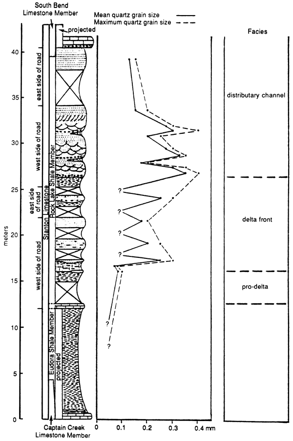
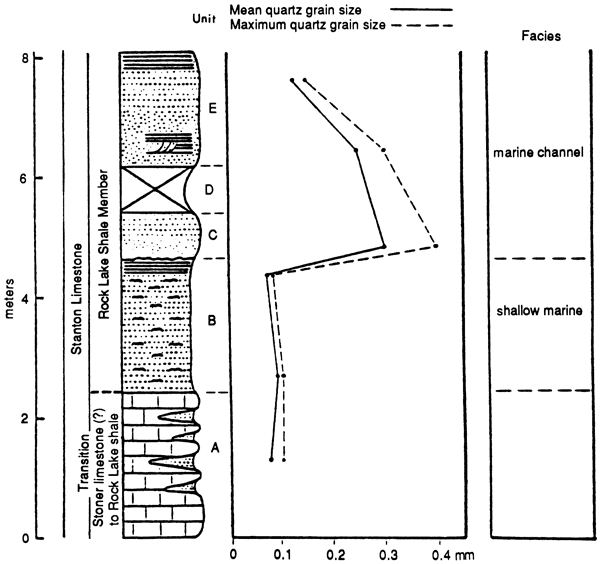
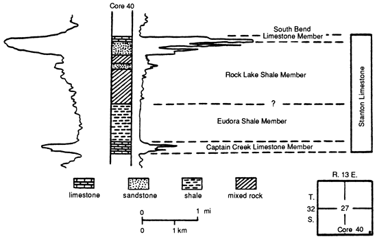
Oklahoma Border Section--In the Oklahoma-Kansas border area the Rock Lake Shale Member consists of several distinct lithologic units. I describe these units in ascending order (fig. 18). The data were obtained from a well-exposed section.
Figure 18--Lithologic units and grain size distribution in Rock Lake Shale Member at Oklahoma border section. Located on west line of NW sec. 14 and west line of SW sec. 11, T. 35 S., R. 14 E. See also Moussavi-Harami (1980, appendix C, section 3).
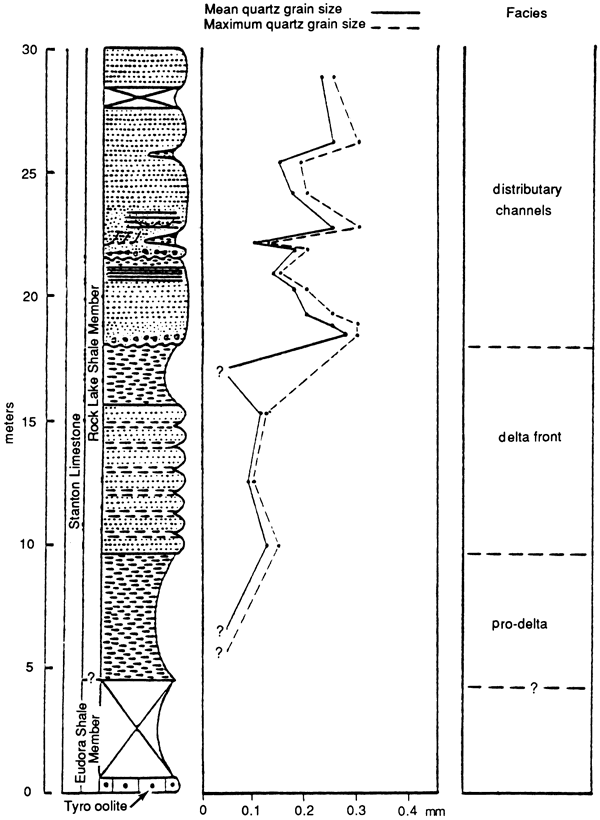
Unit 1 is a calcareous clayey shale at the base that coarsens upward to silty shale at the top. Scattered wood fragments are present. These parallel-bedded clayey and silty shales were probably deposited in a quiet water environment from suspended sediments.
Unit 2 is an interbedded silty shale and well-sorted, very fine grained to fine-grained sandstone with scattered marine fossil fragments (echinoderms, brachiopods, bryozoans, and mollusks) and a few wood fragments. The sandstones are highly calcite cemented, very thin bedded, and locally laminated. These thin-bedded sandstones probably formed intermittently in the lower part of the upper flow regime from coarser sediments that were supplied from the source area in greater amounts.
Unit 3 is a poorly fossiliferous silty shale with scattered wood fragments. This unit was deposited in quiet water from suspensions that contained coarser material than those from which unit 1 clayey shale was deposited.
Unit 4 consists of two horizons of massive, well-sorted, medium-grained sandstone with conglomerates at the base. There is an erosional basal contact with grooves and burrows. The orientation of the basal grooves suggests unidirectional transport, primarily to the northwest. There is no internal stratification in either the massive sandstone or the conglomerate. Pebbles in the conglomerate consist mainly of clay chips derived from the shale unit below and vary in diameter from 1 cm to 2 cm. The presence of an erosional contact with conglomerate at the base and the absence of internal stratification suggest that the massive sandstones in the Rock Lake Shale Member formed by rapid deposition of sediments carried in channels.
Unit 5 consists of planar crossbedded, moderately to well-sorted, fine- to medium-grained sandstones. Because of poor exposure in southern Montgomery County, it was not possible to determine unequivocally the presence or absence of trough crossbedding in this unit. However, it is possible that some of the planar crossbeds are actually oblique to longitudinal views of trough crossbed sets. The planar crossbeds in this unit formed within the upper part of the lower flow regime, as suggested for similar beds in the Rio Grande River by Harms and Fahnestock (1965). The mean azimuth of dip direction of planar crossbeds indicates that the direction of sediment transport was toward the northwest (fig. 19).
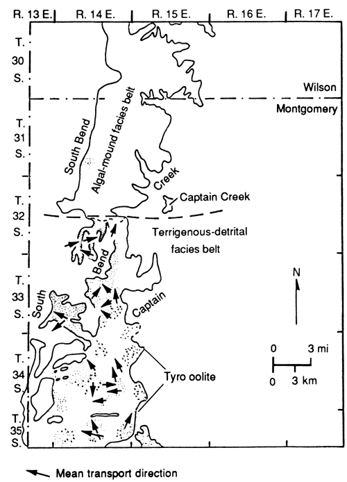
Figure 19--Mean transport directions of planar crossbeds in detrital facies belt.
Unit 6 consists of thin-bedded to very thin bedded and laminated, well-sorted, fine-grained sandstone that grades upward into very fine grained sandstones. Horizontal stratification in channel sandstones is probably a product of plane bed =sport in the transition between the lower and upper flow regimes (Harms and Fahnestock, 1965). Some thin beds of silty shale (less than 1 cm thick) are intercalated with the thin-bedded sandstone toward the top of this sequence. Parallel stratification in the silty shale at the top is probably a product of slow deposition of suspension materials under quiet water conditions. These silty shales are overlain by thin-bedded sandstone with scattered clay chips at the base, which were probably rapidly deposited.
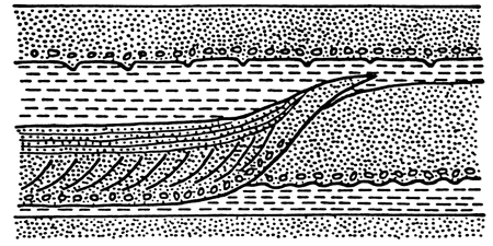
Locally, small-scale cut and fill structures are present (fig. 20). These cut and fill deposits consist of conglomeratic quartz sandstone with shale pebbles at the base overlain by small-scale, thinly planar crossbedded, horizontally laminated sandstone, and parallel stratified silty and clayey shale that is cut by the next sandstone unit above. Grooves and burrows are present at the base of the sandstone unit above the cut and fill structure (fig. 20). The processes that formed these minor channel cuttings are the same as for the major channels already discussed and are probably related to local changes in velocity of the major channel. Within each minor channel the vertical sequence from basal conglomerate upward to medium- and fine-grained sandstone indicates a general decrease in energy during the deposition of sandstone as the channel filled and shifted position. Nevertheless, the overall increase in grain size from base to top reflects a change in deposition from offshore shale to channel sand, which is characteristic of a regressive phase of deposition.
Figure 20--Small-scale cut and fill structure in unit 6 at Oklahoma border section (see fig. 18).
Tyro Quarry--Northeastward in the Tyro quarry (Moussavi-Harami, 1980, appendix C, sections 8 and 9), the base of the Rock Lake Shale Member is a conglomeratic quartz sandstone about 1 m (3 ft) thick. It lies above the dark-gray offshore marine Eudora Shale Member studied by Malinky (1980). The basal conglomeratic sandstone grades upward into thin-bedded sandstone with scattered marine fossil fragments and small-scale cross-laminations that dip alternately east and west in different horizons. Pebbles in the conglomerate are composed of shale, fossils, and fragments of oolitic and other types of limestone. Pebbles range in diameter from 0.5 cm to 6 cm and decrease in size toward the top and to the west. There is no internal stratification in the basal conglomerate. This unit is exposed only in the south wall of the quarry and thins toward the west.
The thinning of this unit and the decrease in pebble size toward the west in conjunction with the absence of this unit in the west and north walls of the quarry indicate that the source must have been to the east or southeast. The pebble composition and the sharp basal contact of this unit indicate that the channel cut into both the underlying offshore shale and perhaps into the Tyro oolite 0.6 m (2 ft) below the outcrop.
Fahnestock and Haushild (1962) stated that pebbles larger than 2.5 cm in diameter with a specific gravity of 2.0 or more cannot be transported downstream in the lower flow regime but will roll into scour pockets formed upstream of the pebbles. Thus such pebbles can be moved downstream only in the upper flow regime. The velocity and turbulence of the depositional environment in the Tyro quarry area decreased to a lower flow regime at the top, as indicated by the thin-bedded sandstone that contains small-scale dune cross-laminations. Small-scale asymmetric ripples (amplitude 0.5 cm) present at the top of this unit indicate that the current velocity decreased even further to the lower part of the lower flow regime and that the direction of transport shifted toward the south (fig. 21). The thin bed of silty shale (about 1 cm) that separates the layered sandstones probably records normal deposition of finer silt-size sediments between pulses of coarser sediment. The overall fining-upward sequence of conglomerate and sandstone containing marine fossil fragments indicates rapid pulses of deposition in marine water with an overall decrease in energy toward the top. It is possible that this marine channel was formed by a spillover of sand down a prodelta slope, scouring into the offshore shale and locally into the underlying carbonate sediment nearby.
Figure 21--Mean transport directions of ripple marks in detrital facies belt.
The silty shale [about 2 m (6.7 ft) thick] that overlies the marine channel sandstone contains widely scattered marine fossils, indicating deposition from suspension under normal low-energy conditions of the encroaching prodelta. At the top this shale is cut by a channel sandstone that is conglomeratic in two levels at the base. Pebbles in the conglomerate are mainly shale chips, which range in diameter from 1 cm to 2 cm. Grooves and load structures at the base of the conglomerate indicate rapid deposition in the upper flow regime. The conglomerate grades upward into a well-sorted, medium-grained, massive sandstone with no internal stratification. This is overlain by a moderately to well-sorted, fine- to medium-grained sandstone with small-scale trough crossbeds that grades upward into a well-sorted, fine-gained, thin-bedded sandstone with ripple marks at the top. Trough crossbeds probably formed in the lower flow regime and represent migrating dunes (Harms and Fahnestock, 1965). The mean azimuth of axes of the trough crossbeds indicates that the direction of transport within the channel was toward the northwest (fig. 22).
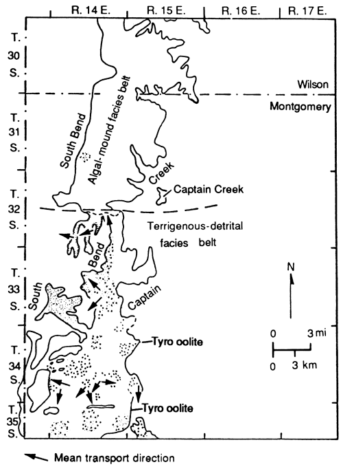
Figure 22--Mean transport directions of trough crossbeds in detrital facies belt. Note unidirectional orientation toward northwest.
In the top of this unit thin-bedded to very thin bedded sandstones with ripples along the surface of the beds formed in the lower part of the lower flow regime. The ripple marks usually have a continuous crest, but some multiripples with crests joined to other ripples are present. This is probably related to changes in direction of wave movement in shallow water. The mean azimuth of these ripple marks indicates that the waves moved toward the south at this locality, perhaps under prevailing winds (fig. 21). There are some very thin beds of silty shale between most of the thin-bedded sandstones. Many scattered shale pebbles occur at the base of the thin-bedded sandstone overlying a shale unit. This indicates that the quiet conditions during the deposition of silty shale were suddenly interrupted by turbulent currents that eroded the upper part of the shale and transported coarser sediments that eventually were deposited over the top. The fining-upward sequence with conglomerate at the base, an erosional basal contact, and the other sedimentary features discussed suggest that these rocks were deposited in a channel system (Allen, 1964; Visher, 1965,1972; Visher et al., 1975; Siemers, 1976).
Cheyenne Creek--~One of the best exposures of Rock Lake sandstone is in a road cut near Cheyenne Creek (NE NE NE sec. 32, T. 34 S., R. 14 E.; Moussavi-Harami, 1980, appendix C, section 6). It consists of three lithologic units. Unit 1, the lowermost unit, consists of interbedded thin-bedded, fine-grained sandstone and silty shale. The sandstone beds are well sorted and contain scattered marine fossils (echinoderms, brachiopods, bryozoans, and mollusks) and a few scattered oolites. Unit 2 consists of interbedded thin-bedded, moderately to well-sorted, fine- to medium-grained sandstone and silty shale. These sandstone beds do not contain marine fossils or oolites. The lower sandstone beds of unit 1 formed under low-energy conditions at a relatively slow rate of detrital influx with perhaps reworked oolites; the upper coarser-grained sandstone beds of unit 2 were deposited under more turbulent conditions with more detrital influx. Unit 3 consists of a thin-bedded, well-sorted, medium-grained sandstone with a conglomeratic base and an erosional basal contact. Pebbles in the conglomerate are primarily shale and range in diameter from 1 cm to 3 cm. This sandstone unit is overlain by trough crossbedded, ripple-laminated sandstone. The mean azimuth of the axes of the trough crossbeds indicates a direction of transport toward the northwest (fig. 22). This sequence along Cheyenne Creek represents a coarsening-upward sequence of shallow marine deposition that was subsequently cut by a channel at the top.
Other Facies--The slightly oolitic quartz sandstone with scattered marine fossils in the third oolite zone in the lower part of the Rock Lake Shale Member was deposited in an agitated shallow-water environment, as suggested by Heckel (1975b). The skeletal oolitic quartz sandstone of the fourth oolite zone, which is crossbedded in some areas, probably records deposition in an even more highly agitated shallow-water environment at a time of low detrital influx. The presence of generally stenohaline organisms (e.g., echinoderms) indicates that nearly normal marine salinities were established during deposition of the lower and middle Rock Lake Shale Member.
Northward, in the vicinity of Wayside between T. 33 S. and T. 34 S., the Rock Lake Shale Member consists predominantly of interbedded clayey to silty shale and very thin bedded, very fine grained, hard, calcite-cemented sandstones. These were deposited under generally quiet conditions with periodically more agitated detrital influx, perhaps between the channels.
West-central Montgomery County
Onion Creek Sextion--Nearly the entire Rock Lake Shale Member is exposed along road cuts near Onion Creek (fig. 23) in west-central Montgomery County. The nonfossiliferous shale at the base of the member is clayey at the base and silty toward the top, indicating suspension deposition in a quiet environment under the influence of a distant but encroaching detrital source. This shale is overlain by a very thin bedded, very fine grained sandstone with burrows on the bottoms of the beds. The presence of ripple marks indicates that this unit was deposited in the lower part of the lower flow regime in shallower water than the shale below. Upward in this sequence there are interbedded thin-bedded to very thin bedded, fine-grained to very fine grained sandstone and covered intervals. If most of the covered intervals represent more easily eroded shale, then these interbeds were deposited under two alternating energy conditions as the detrital source spasmodically approached this area.
Figure 23--Lithology and grain size distribution in Rock Lake sandstone at Onion Creek section. Located along east lines of secs. 22 and 27, T. 33 S., R. 14 E. See also Moussavi-Harami (1980, appendix C, section 20).
The topmost shale unit has been cut by a massive sandstone with a conglomeratic base, which is probably a channel-lag deposit. Unidirectional grooves, which trend northwestward, are present at the base of the conglomerate. Pebbles in the conglomerate are predominantly shale and vary in diameter from 1 cm to 3 cm. Upward in this sequence the conglomerate grades into a well-sorted, medium-grained, massive sandstone with medium-scale trough crossbeds and planar crossbeds and finally into thin-bedded sandstones, illustrating a fining-upward sequence at the top of the section (fig. 23). The channel processes that controlled the deposition of these sandstones were similar to those suggested for the southern Montgomery County sandstones. Very thin beds of silty shale are present between the thin-bedded sandstones, suggesting periodic suspension deposition in a quiet environment. The few scattered shale pebbles in the base of these sandstone units indicate a rapid influx of sand above partially coherent shale.
All the evidence indicates that the lower sandstone and shale units were deposited in a generally quiet environment under increasing detrital influx, such as a prodelta or a delta front. The upper sandstone was deposited in a more turbulent environment with periodic pulses of sediment influx followed by decreasing energy conditions, such as would be found in a channel system. A sequence of three sand-filled channels cutting into shales suggests fluctuating supplies of sediment from source areas, perhaps a result of channel abandonment and reoccupation or perhaps channel meandering. The mean azimuth of the axes of the trough crossbeds indicates that the direction of transport in the channels was toward the northwest (fig. 22).
Coon Creek Section--Northward along US-1 60 at Coon Creek (Moussavi-Harami, 1980, appendix C, section 25), a medium-grained, crossbedded sandstone unit with a conglomeratic base overlies silty shale, and except for the 0.9-m (3-ft) thick Timber Hill siltstone bed, the lower interbedded sandstone and shale facies is absent. In this area the basal offshore shale with marine fossils (Eudora Shale Member) below the Timber Hill bed is thicker than to the south (fig. 4). The Timber Hill siltstone bed contains a few scattered marine fossils and may represent the marine reworked distal end of a sandstone in the Onion Creek area. The grain size within the Timber Hill siltstone decreases toward the top and to the west. This indicates that the source area was probably to the east or southeast and supports the idea that the Timber Hill bed resulted from marine reworking of a greater than normal sand influx from the usual Rock Lake source.
The lower part of the Rock Lake Shale Member above the Timber Hill bed is a nonfossiliferous silty shale that is cut by sandstone at the top. The shale was deposited in a quiet environment but probably more rapidly and from a closer source than the underlying less silty, fossiliferous Eudora Shale Member. The conglomeratic base of the overlying sandstone contains shale pebbles that have the same composition as the shale unit below.
The sandstone is composed of an ascending sequence of (1) a moderately to well-sorted, medium-grained, massive sandstone; (2) a well-sorted, fine- to medium-grained, thin-bedded sandstone with medium-scale trough crossbeds; (3) a well-sorted to medium-grained, thin-bedded sandstone with small-scale planar crossbeds; and (4) a well-sorted, fine-grained, thin-bedded to very thin bedded sandstone with ripple marks.
Below the top of the Rock Lake Shale Member by 1.2 m (4 ft) is a thin-bedded to laminated convolute deformational structure. Petrographic measurements of quartz grains from convolute structures and thin-bedded sandstones above and below indicate no significant differences in grain size. It is likely that the laminations in the convolute structures formed during periods of slow sedimentation. However, rapid deposition of thin-bedded sandstone under high velocity and turbulence conditions may have caused the laminated units to be deformed into the convolute structure by means of a loading phenomenon. The mean azimuth of the dip of the trough crossbed axes indicates a direction of transport toward the northwest (fig. 22). The mean of directions of planar crossbeds indicates a transport direction toward both the north and northeast (fig. 19), whereas the mean azimuth of the ripple mark crests and the sense of asymmetry indicate a direction of transport to the west (fig. 21). The lack of shale interbeds at this locality suggests continual higher-energy conditions, possibly in shallower water than stratigraphically lower sandstones.
All the evidence suggests that this sand was deposited in channel systems. The two sand-filled channels visible in the Rock Lake Shale Member at Coon Creek are probably related to migration of a channel toward the north. The medium-grained massive sandstone of the upper channel cuts into the fine-grained, thin-bedded, ripple-laminated sandstone of the lower channel. The lack of conglomerate at the base of the massive sandstone of the upper channel indicates that deposition took place in the presence of coarser incoherent sediments.
Summary of Rock Lake deposition in the detrital facies belt
The general vertical sequence of Rock Lake lithology in western Montgomery County consists of (1) clayey shale at the base becoming silty upward; (2) interstratified thin-bedded, very fine grained to fine-grained sandstone and silty shale; (3) massive medium-grained sandstone with conglomerate at the base; (4) medium-scale trough crossbedded, fine- to medium-grained sandstone; (5) fine-grained, planar crossbedded sandstone; and (6) thin-bedded, fine-grained to very fine grained sandstone. This records progressive encroachment of prodelta (items 1 and 2), distributary channel (items 3-5), and overbank deposits (item 6) of a delta lobe.
Tributary to Wilson County channel
In Wilson County the only good vertical exposure of Rock Lake sandstone is along K-47 east of Fredonia in a small channel that is cut into the Stoner Limestone Member. This channel is a tributary to the larger Wilson County channel. At this locality the base of the Rock Lake Shale Member consists of a thin (7 cm) clayey and silty shale that was deposited under quiet water conditions. This shale unit is cut by sandstone at the top (fig. 24). The base of the sandstone is conglomeratic, with shale pebbles and a few scattered fossil fragments forming a channel-lag deposit. The pebbles vary in diameter from 1 cm to 3 cm. Upward in this sequence the sandstone is well sorted and thin bedded with medium-scale trough crossbeds; it grades upward into a well-sorted, horizontal thin-bedded, ripple-laminated sandstone. A few small-scale cut and fill structures are present. The mean azimuth of the axis of trough crossbeds indicates that the direction of transport was southwesterly, toward the main channel (fig. 25). This coincides with the apparent alignment of the tributary channels. The medium-grained sandstone at the base fines upward to fine-gained at the top (fig. 24). The conglomerate at the base formed under upper flow regime conditions. As the velocity and turbulence decreased, trough crossbeds formed in the upper part of the lower flow regime. Flow energy probably increased again to form the horizontal beds in a transition between the lower and upper flow regimes (Harms and Fahnestock, 1965). Higher in this sequence ripple marks formed as the velocity decreased again to the lower part of the lower flow regime.
Figure 24--Lithology and grain size distribution in small tributary to Wilson County channel at K-47 section. Located in north side of road cut along K-47 in north-central sec. 16, T. 29 S., R. 15 E. See also Moussavi-Harami (1980, appendix C, section 28).
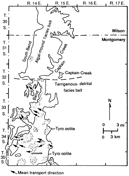
Figure 25--Direction of sediment transport in channels transecting algal-mound tract. Note unidirectional orientation of trough crossbeds.
Westward in the subsurface, core K shows a series of channel cut and fill structures, each with a channel lag of conglomeratic quartz sandstone at the base and massive to crossbedded sandstone grading to silty shale at the top.
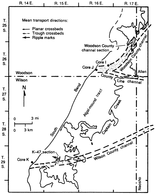
Woodson County channel
One of the best exposures of the Woodson County channel in the Rock Lake Shale Member is in the hill west of Humboldt (fig. 26). At this locality the lower part of the outcrop (unit A) is skeletal to lithoclastic calcirudite with small-scale planar crossbeds and lenses of very fine grained, laminated sandstone. This unit probably represents erosional debris derived from semiconsolidated Stoner limestone and incorporated into the base of the Rock Lake Shale Member. Small-scale dunes and ripples are present in the interbedded sandstone, indicating deposition in the lower flow regime. It is possible that these lenses formed at the edge of the channel during high siliciclastic sediment supply. The overlying very fine grained, thin-bedded sandstone (unit B, fig. 26) with laminated ripples and dunes was also deposited in the lower flow regime. This unit is cut at the top by a well-sorted, medium-grained sandstone (unit C) that has grooves and burrows at the base. The grooves indicate unidirectional transport toward the south and southwest. The entire sandstone unit (C-E on fig. 26) is massive at the base and thin-bedded to very thin bedded to laminated toward the top, fining upward in grain size. Small-scale channel cut and fill structures may be related to local shifting of the channel in the upper flow regime. Fining-upward crossbeds and ripple laminations also are present down-channel in the subsurface. The evidence supports the idea that these rocks were deposited in the large channel mapped by Heckel (1975a).
Figure 26--Lithology and grain size distribution in Woodson County channel in cut on hill west of Humboldt. Located on north side of road cut in SW SW sec. 34, T. 25 S., R. 17 E. See also Moussavi-Harami (1980, appendix C, section 33).
Well-log interpretation
Four different lithofacies were identified in the subsurface by using resistivity and SP logs in conjunction with outcrop data (fig. 27), as described in the previous section. These lithofacies are (1) limestone, (2) sandstone, (3) shale (mainly clayey), and (4) mixed rock (mixture of clayey or silty shale and shaly sandstone). The thickness of the Rock lake Shale Member, predominantly sandstones and mixed rock, increases from north to south. The net sand isolith map (fig. 13) and cross section AB (fig. 14) indicate that the amount of sandstone increases southward toward the Oklahoma border. These facts, in conjunction with sandstone geometries, indicate dot the source area for the Rock Lake siliciclastics was toward the south and southeast.
Figure 27--Lithologic interpretation of well-log signatures of Stanton Limestone 4 mi (6.4 km) west of outcrop in detrital facies belt.
Higher resistivity and SP values at the base of the Stanton Limestone indicate the presence of limestone, interpreted to be the Captain Creek Limestone Member (fig. 14) in the northern part of the detrital belt (T. 32 S. and T. 33 S.). This interval is overlain by units characterized by low resistivity and low SP values, indicating fine-grained, clay-rich sedimentary rocks, interpreted to be the Eudora Shale Member, deposited under widespread quiet water, offshore conditions at maximum transgression. Upward in the sequence the fluctuation of resistivity and SP values indicates the presence of fine- and coarse-grained sediments that are interpreted as mixed rock. The low values probably represent finer-grained sediments (clay and silt) deposited under quiet water conditions from suspension; the higher values represent coarse-grained sediments (sand) deposited under conditions of greater sediment influx and perhaps higher energy. A similar sequence is seen in the exposed rocks in the vicinity of Onion Creek (fig. 27), but the mixed rock overlies silty shale in the lower part of the Rock Lake Shale Member. This mixed-rock subsurface interval is overlain by a unit with high resistivity and SP values that indicates coarser-gained sediments. These probably represent a medium-grained sandstone, possibly channel-fill sediments deposited under high to low flow regime, if this unit is analogous to the outcropping rocks of the upper part of the Onion Creek sandstone body that cuts into finer-grained sediments 6.4 km (4 mi) to the east. At the top of this sequence the widespread horizon of high resistivity and SP values is interpreted to represent the South Bend Limestone Member, which overlies the sandstone and represents the next transgressive phase of deposition.
Southward between T. 33 S. and T. 34 S., most resistivity and SP values decrease, although some thin intervals with high values persist (fig. 14, wells 47, 147, and 143). The lower resistivity and SP values are interpreted as mixed rock, representing a unit of finer-grained sediments, for example, very fine grained sandstones interbedded with silty shale such as those seen cropping out in the vicinity of Wayside along US-65. These units were probably deposited under relatively low-energy conditions. The thin intervals of high resistivity and SP values probably represent lenses of fine- to medium-grained sands that were probably deposited under higher-energy conditions. Some of the thicker sand lenses can be correlated with channel sands both northward and southward (fig. 14). This suggests shifting of channels during periods of increased detrital influx.
In the southern part of the detrital belt (T. 34 S.) in wells 134 and 138, the high to low resistivity sequence of the Tyro oolite-Eudora shale sequence disappears and is replaced by high resistivity and SP values (fig. 14), which are interpreted as representing coarser-grained sand-size sediments that fill a channel. This indicates an increase in coarse detrital influx from the south at a much earlier stage of Rock Lake deposition than is seen to the north and an influx that resulted in the erosional removal of the lower units of the Stanton Limestone followed by deposition of channel sands. Some abrupt vertical changes in resistivity and SP curves above these sediments are interpreted as a sequence of interbedded sandstone and very thin bedded shale within the channel deposits, as seen in some outcrops. These represent periods of quiescence interrupting normally high-energy conditions in the channels. In wells 134 and 138 the thick sequence of channel-sand deposits (higher resistivity and SP) are overlain by alternating intervals of low and high resistivity and SPs (fig. 14), indicating interbedding of finer-grained mixed rock and coarser-grained sandstone, which record deposition under two different energy conditions. This interbedding might represent encroachment of floodplain deposits, but because these have not been observed in outcrops, it might merely reflect alternation between suspension deposition during low channel flow stages and higher flow regime sand transport during floods or possibly shifting of channels across quiet interdistributary-bay suspension deposits.
These alternating sequences of high and low resistivity and SP values are next overlain by an interval characterized by high resistivity and SP values that represent a thick sequence of coarse-grained sandstone (fig. 14), which was probably deposited in a new major channel that shifted into the area. In well 138 this interval of high resistivity and SP deflection is directly overlain by the widespread high-resistivity values that are interpreted to be the next transgressive limestone unit (South Bend Limestone Member) capping the Stanton Limestone. However, in well 134 the high values of the sandstone intervals are overlain by a low-value interval of finer-grained mixed rock, indicating shifting of the major channel away from this area some time before the South Bend transgression.
Southward in well 107, 1.6 km (1 mi) north of the Oklahoma border (fig. 14), the Rock Lake Shale Member consists of three different units. Unit 1, the lowermost unit, has low resistivity and subdued SP curves that indicate finer-grained mixed rock deposited under relatively quiet conditions. Unit 2 exhibits high-valued curves that are interpreted as coarser sediments, probably a medium-grained sandstone similar to that observed in correlative outcrops, deposited under higher flow regimes in channel systems. Unit 3 has low resistivity and subdued SP curves at the top of the sequence, which represents finer-grained mixed rock. This sequence shows an upward decrease in grain size and an upward decrease in current energy conditions and is probably related to the shifting of a channel complex away from this area some time before deposition of the overlying transgressive limestone.
The general trend of increasing resistivity and SP deflections upward through most of the subsurface Rock Lake Shale Member indicates gradual coarsening (i.e., a decrease in clay content) and an increase in siliciclastic influx through time. This sequence of rocks, which appears to represent a regressive or progradational phase of deposition, grades upward from offshore clayey and silty shales to nearshore mixed sandstones and shales to channel sandstones. Southward thinning of offshore clayey and silty shales as they are replaced from the top of mixed rock and channel sandstones (fig. 14) seems related to a progressive increase in supply of coarse siliciclastic sediments from the southern source area.
Process-response depositional model for the Rock Lake Shale Member of the Stanton Limestone in the detrital facies belt
By combining data from regional stratigraphic studies, outcrop observations, and well-log interpretations, I have developed a depositional model for sandstones and shales of the Stanton Limestone in the detrital facies belt of southeastern Kansas. This model is a process-response model developed by asking the following question: Given the regional geologic setting of the Pennsylvanian sea, what reasonable processes based on modern analogues could have formed the physical characteristics of the rocks observed today (Brenner, 1980)? Reconnaissance study by earlier workers suggested that siliciclastic sediments of the Stanton Limestone may have been deposited in deltaic environments (Wilson, 1957a,b; Harbaugh, 1962; Kenny, 1968; Heckel, 1975a, 1975b, 1977, 1978). The older Chanute Shale of the Kansas City Group (fig. 1) has been interpreted as a deltaic deposit with a southerly source (Haggiagi, 1970). S. L. Brown (1967) stated that the younger Elgin Sandstone Member of the Virgilian Stage exposed in Chautauqua County, Kansas, had a source from the south and was deposited in deltaic distributary channels. The older Warner, Little Cabin, and Hartshorne sandstones (Desmoinesian Stage, Middle Pennsylvanian) in northern Oklahoma were deposited in deltaic environments with an easterly source from the Ozark dome area (Scruton, 1950). L. R. Brown (1969, 1973, 1979) interpreted the Upper Pennsylvanian sandstones and shales in north-central Texas as deltaic deposits. The Coffeyville Formation (Lower Missourian) of northern Oklahoma was interpreted as a deltaic deposit with a southerly source by Visher et al. (1975).
The Rock Lake Shale Member was deposited during a regressive phase of cyclic deposition characteristic of the Pennsylvanian epicontinental sea in midcontinent North America (Heckel, 1977,1980). In the present study sedimentologic analysis and facies relationships between different units of the Rock Lake siliciclastics in both surface exposures and subsurface well logs in the detrital facies belt strongly suggest that these rocks were deposited in a fluvial-dominated deltaic environment. Thinning of offshore shales and concomitant thickening of sand units toward the south (figs. 13 and 14), in conjunction with unidirectional trough crossbeds to the northwest (fig. 22) in sandstone outcrops, suggest that the Rock Lake sediments entered the basin from the south and southeast of the study area. The presence of well-rounded quartz overgrowths and the dominance of rounded, well-sorted quartz grains in the quartzarenitic sandstones of the Rock Lake Shale Member suggest that the source was preexisting sedimentary rocks, probably in the tectonically active Ouachita Mountain belt.
Based on the information presented here, I propose a two-phase process-response model for the siliciclastic sediments of the Rock Lake Shale Member of the Stanton Limestone in the detrital facies belt.
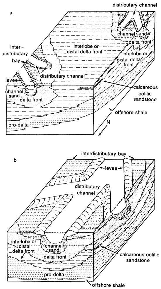
Figure 28--Process-response depositional model for Rock Lake Shale Member of Stanton Limestone in detrital facies belt. (a) Early regression. (b) Late regression.
Phase 1
During early regression (fig. 28a), the delta complex was located to the south and southeast of the study area. Because of the low rate of detrital influx, a thin sequence of offshore mud with marine fossils (clayey shale of the Eudora Shale Member) formed in the detrital bell Progradation of the delta to the north caused the thick sequence of clayey and silty mud of the prodelta to be deposited from suspended sediments under quiet, relatively offshore marine conditions, forming the lower Rock Lake Shale Member (and the upper Eudora Shale Member, where thick). The boundary between these two shale units is gradational and ascends northward in the study area. As the delta prograded to the north, interbedded very thin bedded, very fine grained to fine-grained sands, silts, and muds were deposited in distal delta-front environments and interlobe areas (fig. 28a) under variable water depths and low-energy conditions. These beds contain a few scattered marine fossils, such as echinoderms and brachiopods, in the lower part of the Rock Lake Shale Member in the southern portion of the detrital facies belt.
The presence of lenses of calcareous oolitic sandstone with crossbeds and scattered marine fossils (third and fourth oolites) in southern Montgomery County (T. 34 S. and T. 35 S.) indicates that the water was locally shallow and agitated. This allowed the oolitic sands to be formed and deposited in areas away from active detrital influx (fig. 28a). Gradational contacts between these oolitic sandstones and sandstone units below suggest that the constituent grains of oolite formed nearby or in place. The presence of stenohaline echinoderms indicates that nearly normal marine salinity was established during deposition of these calcareous horizons. Lateral discontinuity of the beds within each possibly correlative horizon suggests two possible factors in the deposition of these units: (1) They formed only in the most shallow and thus warmest and most agitated water on local highs in the broad interlobe areas, or (2) they formed in local areas only during times of generally reduced detrital influx, perhaps when dry climates prevailed.
Phase 2
Both eustatic lowering of sea level during later regression and slow subsidence of the prodelta deposits allowed the delta front to prograde northward in the study area. As the delta prograded, coarse-grained sand was transported into southern Kansas and deposited as interbedded thin-bedded delta-front sands and muds (fig. 28b). The presence of a few scattered marine fossils in these units indicates that deposition was still slow enough to allow these organisms to live under slightly turbid conditions.
Northward, progradation of the delta caused distributary channels to cut into previously deposited delta-front sandstones and shales. This was a time of more rapid detrital influx from the source area. In later Rock Lake time conglomeratic channel-lag deposits with unidirectional grooves and erosional bases were deposited under high flow regime conditions to the upper part of the lower flow regime conditions in the distributary channels. These rocks are overlain by massive to thin-bedded, medium-grained sands with unidirectional trough crossbeds (fig. 22). Grading laterally from the channel-fill deposits, interbedded silts and silty or clayey muds were deposited in interdistributary bays from suspension under low-energy (current and turbulence) conditions. An idealized north-south cross section across the detrital facies belt (fig. 29), based on surface and subsurface data, shows the relationships among the different facies of Stanton siliciclastics. Maximum transgression is indicated by the offshore phosphatic black and dark-gray fissile shale with mostly pelagic marine fossils. This shale was deposited slowly under low-oxygen bottom conditions (Heckel, 1977, 1980) during early Eudora time. The black shale grades upward into gray clayey shale with a diverse benthic and pelagic marine fauna deposited under higher-oxygen bottom conditions. As the delta prograded into the southern part of the study area, siltier mud of the prodelta was deposited more rapidly on top of the offshore shale in the south. At the same time, this increasing rate of detrital influx to the north caused deposition of a thicker sequence of marine mud, forming the upper part of the thicker Eudora Shale Member to the north.
At the top of the offshore shale between T. 33 S. and T. 34 S. is a skeletal calcarenite (Bolton bed) that contains a normal marine fauna of unabraded fossil material and scattered oolites. All evidence derived from this study supports the interpretation of Heckel (1975b) that this limestone lens was deposited in a quiet-water, offshore environment under low sediment influx, into which ooids were periodically transported from a more strongly agitated shoal.
As the delta prograded to the north, very thin bedded sands, silts, and muds of the interlobe or distal delta front were deposited progressively northward over the prodeltaic mud in the southern portion of the detrital facies belt (fig. 29). At the same time, the prodelta moved northward into the northern portion of this belt. Lenses of calcareous oolitic sands (third and fourth oolites) formed in the southern area, perhaps during times of generally lessened detrital influx within this sequence (figs. 28a and 29). During a period of rapid detrital influx, a pulse of silt-size sediment was washed, perhaps by storm-generated floods, from interlobe or distal delta-front deposits and deposited and then reworked as a fairly clean silt lens (Timber Hill bed) within the muddy prodelta deposits in the northern end of the detrital facies belt (fig. 29).
Figure 29--Idealized north-south cross section of Stanton Limestone in detrital facies belt showing probable relationships among different facies. All dash-dot patterned areas between top of Eudora Shale Member (white) and base of South Bend Limestone Member (wavy line) constitute the Rock Lake Shale Member in this area. For location, see figs. 2 and 4.
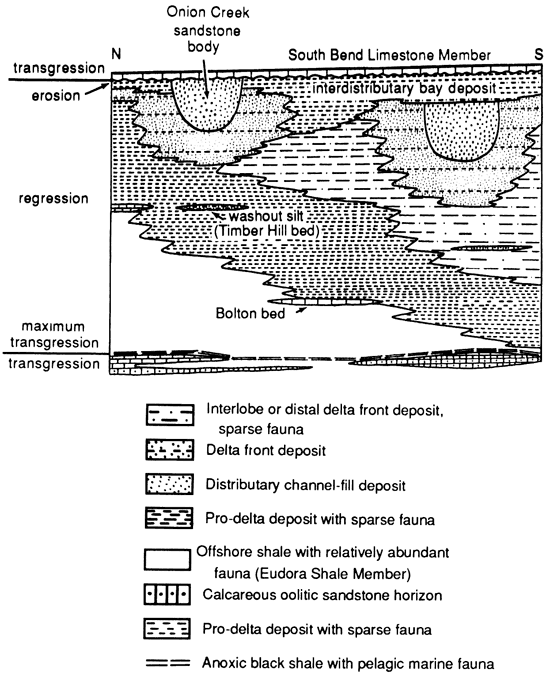
Continued sediment influx with little delta subsidence eventually allowed the distributary channel to move into the southern part of the study area and to cut through the delta-front silt and sand (figs. 28b and 29). The erosional contact beneath the conglomerate at the base of the channel records high flow regime conditions, which left channel-lag deposits. A subsequent decrease to the higher part of the lower flow regime left massive to thin-bedded sandstones with unidirectional trough crossbeds within the distributary channel. Small-scale channel cut and fill structures in these segments probably represent periods of rapid increase in detrital influx in the lower flow regime in the channel. As the distributary channel was abandoned and shifted northward along the eastern margin of the sea, it became filled with finer sediments, leaving interbedded very fine grained to fine-grained sands and silty mud at the top of the channel fill, which grades upward into interdistributary muds deposited from suspension.
Deltaic distributary channel deposits are similar to alluvial channel deposits. Fining-upward sequences in fluvial distributary channels are related to slow lateral migration of channels or, more abrupt, channel abandonment. Finer-grained sediment toward the top grades into overbank flood sediment of an adjacent active channel (Reading, 1978). The presence of marine organisms in the lower sandstones and shales and partly equivalent third and fourth oolite horizons in conjunction with lateral relationships between the different units of the Rock Lake and upper Eudora shale members indicates that these channels are deltaic distributary channels rather than alluvial systems. Interbedded very thin bedded (locally laminated), very fine grained sandstone or siltstone and clayey to silty shales (between T. 33 S. and T. 34 S. in the vicinity of Wayside along US-75) were probably deposited in an interdistributary bay. It is possible that delta-front sands may have formed as bar-finger sands similar to those of the Mississippi delta complex described by Fisk (1961). However, poor exposures and insufficient subsurface control make this a conjectural interpretation.
As distributary channel systems shifted to the north (T. 33 S.), delta-front sands and muds were deposited. These are represented by the lower part of the Onion Creek sandstone body (fig. 29). Subsequently, the Onion Creek distributary channel system cut through these delta-front deposits as sediment influx increased without much subsidence of the delta, producing the massive upper part of the Onion Creek sandstone.
This was probably the last major deltaic system established before the time of maximum regression in the exposed portion of the detrital facies belt, because the Onion Creek sandstone is overlain by the basal conglomeratic quartz sandstone of the South Bend Limestone Member, which records early marine transgression on the erosional surface (Heckel, 1975b) that records maximum regression. Further transgression to below wave base is recorded by the widespread calcilutite at the top of the South Bend Limestone Member (Heckel, 1975b).
The Rock Lake deltaic system is different from most well-known modern deltaic systems because of the association of the deltaic facies with extensive carbonate deposition on the Pennsylvanian stable cratonic shelf of North America.
Paleogeographic summary
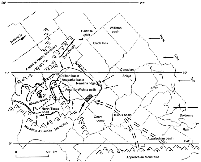
During the Middle Pennsylvanian thick sequences of deltaic sediments with a northerly source were deposited in northern Oklahoma (Visher et al., 1971). The major sources for clastics during this time were the Appalachian Mountains far to the east, the Ouachita Mountains and the Amarillo-Wichita uplift to the south, the Canadian Shield to the north, the Nemaha Ridge to the west, and the ancestral Rocky Mountains far to the west (fig. 30). The Ouachita, Canadian, and Nemaha sources were most accessible to the area of study. Periodically the sea transgressed to the north, establishing a broad carbonate shelf over much of the midcontinent and resulting in cyclic sedimentation (Wanless, 1967; Moore, 1979).
Figure 30--Paleogeography and source of siliciclastic sediments during deposition of Rock Lake Shale Member (Missourian Stage, Upper Pennsylvanian) in central United States [modified from Heckel (1980)]. The Nemaha Ridge is covered by upper Missourian deposits. Shaded area is area of study. Solid line indicates probable extent of epicontinental sea during early Rock Lake deposition. Dashed line represents approximate boundary of basins in West Texas-Oklahoma area. Solid arrow shows definite source of Rock Lake siliciclastics. Dashed arrows show less likely sources of Rock Lake siliciclastics.
During the early Missourian (early Late Pennsylvanian) the Nemaha uplift became thinly covered by marine carbonate sediment (Moore, 1979) and was no longer a significant source of clastic sediments in the southern midcontinent. By late Missourian time the northern midcontinent was characterized by a shallow carbonate shelf, resulting in a relatively thick sequence of predominantly carbonate sediments in this region.
The series of major transgressions and regressions that caused widespread units of cyclic sedimentation in the midcontinent throughout the Middle and Late Pennsylvanian reflect eustatic sea-level changes related to glaciation in Gondwanaland (Wanless and Shepard, 1936; Crowell, 1978; Heckel, 1980). In the units studied, initiation of a major transgressive sequence is represented by the upper part of the Vilas Shale. Further transgression is marked by the widespread Captain Creek Limestone Member and equivalent Tyro oolite. Maximum transgression is represented by the thin black phosphatic facies of the Eudora Shale Member (fig. 29).
The Rock Lake Shale Member of the Stanton Limestone in the detrital facies belt of southern Kansas was deposited during the entire regressive phase of deposition, whereas the Stoner Limestone Member formed to the north (figs. 4 and 14). Thickening of siliciclastic sediments toward the southeast (figs. 12 and 13) in conjunction with dipping of unidirectional trough crossbeds to the northwest (fig. 22) in this area indicate that the source area for the detrital belt was the Ouachita Mountains, which were uplifted earlier in the Pennsylvanian (fig. 30). Deposition of the lower part of the Rock Lake Shale Member occurred as deltas encroached on the detrital belt of southeastern Kansas (fig. 28a). At the same time, Stoner carbonates were forming to the north. The general mean azimuths of ripple marks in the upper Rock Lake Shale Member toward the south and west (fig. 21) suggest that currents generated by the prevailing winds were moving from northeast to the southwest, which coincides with the trade winds direction (fig. 30) postulated by Heckel (1980).
As the sea started to withdraw from the detrital facies belt toward the west, the upper part of the delta complex prograded into the study area from the south and southeast (fig. 28b). Distributary channel-filling sands and finer-grained interdistributary bay sediments were deposited in the study area, where they are represented by sandstones, siltstones, and shales of the upper Rock Lake Shale Member. Further withdrawal of the sea to maximum regression is represented by the erosion surface at the top of the Rock Lake Shale Member below the conglomeratic basal South Bend Limestone Member in southeastern Kansas, in which clasts of diverse origin represent a variety of lithic materials available on the erosion surface (Heckel, 1975b).
The two marine channel-filling sandstones of the Rock Lake Shale Member in the northern part of southeastern Kansas had their immediate source to the east, with sediment from a more eastern deltaic environment washed into preexisting depressions in the Stoner carbonate shelf of Wilson and Woodson counties (fig. 25). This indicates that deposition of the Rock Lake Shale Member in the algal-mound facies belt took place mainly during the late regressive phase of deposition, when the sea was withdrawing from the Stoner carbonate shelf in the northern part of the study area.
Prev Page--Petrographic analysis || Next Page--Conclusions
Kansas Geological Survey, Geology
Placed on web Nov. 4, 2010; originally published 1990.
Comments to webadmin@kgs.ku.edu
The URL for this page is http://www.kgs.ku.edu/Publications/Bulletins/GS5/05_sed.html