![]()
Prev Page--Introduction || Next Page--Petrographic analysis
Stratigraphy
Outcrop belt
The Stanton Limestone is exposed along a north-south outcrop belt in eastern Kansas and increases in thickness from 10.5 m (34.4 ft) in the northeast to 35 m (115 ft) southward at the "standard section" in northern Montgomery County (Heckel, 1975b), which is the most completely exposed section of the Stanton Limestone in this area. Based on lateral continuity of the capping South Bend Limestone Member and the basal Tyro oolite bed, Cocke (1970) and Heckel (1975b) have recognized equivalent strata southward through Montgomery County into the upper Wann Formation of northeastern Oklahoma.
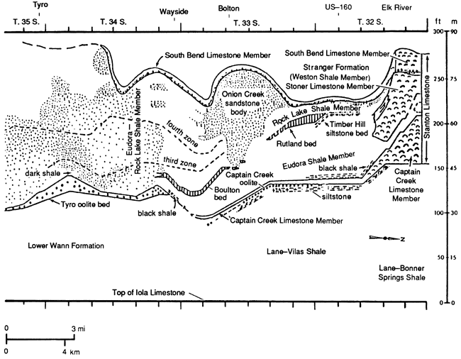
At the standard section in northern Montgomery County at the southern end of the algal-mound facies belt (fig. 4, right-hand side), the Stanton Limestone is composed of, from base to top: (1) the Captain Creek Limestone Member, about 15 m (49 ft) of medium-bedded skeletal calcilutite grading upward into massive phylloid algal-mound facies; (2) the Eudora Shale Member, 1.5 m (5 ft) thick and essentially covered (Heckel, 1978, p. 40); (3) the Stoner Limestone Member, 11.4 m (37.4 ft) of thin-bedded shaly skeletal calcilutite and fossiliferous shale, grading upward to massive phylloid algal limestone; (4) the Rock Lake Shale Member, 1.2 m (3.9 ft) of sparsely fossiliferous gray shale with lenses of sandstone; and (5) the South Bend Limestone Member, about 6 m (20 ft) of sparsely algal skeletal calcilutite with oolitic quartz sandstone at the base (Heckel, 1975b). All members of the Stanton Limestone undergo a radical change laterally from the south end of the algal-mound facies belt across the terrigenous-detrital facies belt (Heckel, 1975a,b, 1978).
Figure 4--Generalized cross section showing subdivisions and facies of Stanton Limestone along outcrop across terrigenous-detrital facies belt in Montgomery County, Kansas [simplified from Heckel (1975b, p. 8)].
Captain Creek Limestone Member
The Captain Creek limestone thins southward from about 15 m (49 ft) of phylloid algal calcilutite at the standard section to 1.5 m (5 ft) along US-160 (Heckel, 1975b). Between US-160 and US-75 the Captain Creek limestone is 1.5-2.1 m (5-7 ft) thick and consists of two massive limestone beds separated by fossiliferous sponge-rich calcareous shale. The upper limestone is a sponge-rich skeletal calcilutite, and the lower limestone is an oolite. Both limestones disappear south of US-75, southwest of Bolton.
The Tyro oolite (Strimple and Cocke, 1969; Heckel, 1975b) appears about 2 km (1.2 mi) farther south at the stratigraphic level of the Captain Creek limestone (fig. 5). It is a yellowish- to orange-weathering crossbedded oolitic limestone with scattered marine skeletal fragments. Heckel (1975a) and Senich (1978) reported a 1-cm-thick bed of skeletal calcilutite at the top of the Tyro oolite at the type section (south wall of the Tyro quarry), which may be equivalent to the upper skeletal calcilutite bed of the Captain Creek Limestone Member to the north. The Tyro bed is persistent throughout southern Montgomery County and as far as 3.2 km (2 mi) into Oklahoma.
Eudora Shale Member
The Eudora Shale Member thickens southward substantially from the algal-mound belt into the north end of the detrital belt, where it is separated from the Rock Lake Shale Member by the Timber Hill, Rutland, and Bolton beds (fig. 4). The Eudora shale is a 17.5-21-m (57-69-ft) thick gray shale along US-160 with a 0.3-0.6-m (1-2-ft) bed of black shale at the base (encountered in drilling; Wilson, 1957a; Heckel, 1975b). The upper 6 m (20 ft) of the Eudora shale exposed in this section contains two distinct zones of marine fauna related to turbidity (Heckel, 1975a,b, 1978; Wood, 1977; Senich, 1978). Eastward the Eudora thickens to 22.5 m (74 ft) around Walker Mound, where the exposed black shale contains phosphate nodules and a pelagic fauna. The Eudora shale thins farther southward to 5.4 m (18 ft) beneath the Bolton bed in southern T. 33 S., where it becomes a gray marine shale with black facies at the base (fig. 4). Southward, where the Bolton bed pinches out, the Eudora and Rock Lake shale members are not easily differentiated, except in the Tyro quarry where 0.3-0.6 m (1-2 ft) of dark-gray Eudora shale containing scattered phosphorite nodules and marine fauna (Malinky, 1980) is overlain by 0.9-1.2 m (3-4 ft) of conglomeratic quartz sandstone (Heckel, 1975a,b, 1978; Heckel et al., 1979; Senich, 1978), which Heckel (1983) has placed in the Rock lake Shale Member.
Stoner Limestone Member
The Stoner Limestone Member is 11.4 m (37.4 ft) thick and consists of shaly skeletal calcilutite, shale, and phylloid algal limestone at the standard section in northern Montgomery County. It is as much as 12 m (39 ft) of more solid limestone westward along the Elk River valley (Heckel, 1978). Southward the Stoner limestone thins and pinches out as it grades into a shale sequence 1.6 km (1 mi) into the northern part of the detrital facies belt (fig. 4).
The Timber Hill bed (Heckel, 1975b) is 0.6-1.2 m (2-4 ft) of thin-bedded quartz siltstone that is well exposed along the east side of Timber Hill. Stratigraphically, it overlies shale that is equivalent to the Stoner limestone. At its southernmost exposure the Timber Hill bed (fig. 4) is overlain by the Rutland bed.
The Rutland bed (Heckel, 1975b) ranges from 0.3 m (1 ft) to 2.4 m (7.9 ft) thick. Although this calcarenitic limestone bed differs from the largely calcilutitic facies of the Stoner Limestone Member, its stratigraphic position suggests that it is equivalent to the top of the Stoner limestone (fig. 4).
The Bolton bed (Heckel, 1975b) is the southernmost limestone bed overlying the Eudora Shale Member in the detrital facies belt (fig. 4). It ranges in thickness from 0.3 m to 1.35 m (1-4.4 ft) and consists largely of unabraded invertebrate material. This bed is probably equivalent to the lower Stoner Limestone Member, based on its stratigraphic position and similar conodont fauna (Heckel, 1975b; Wood, 1977).
Rock Lake Shale Member
The Rock Lake Shale Member is the most lithologically variable member of the Stanton Limestone in eastern Kansas.
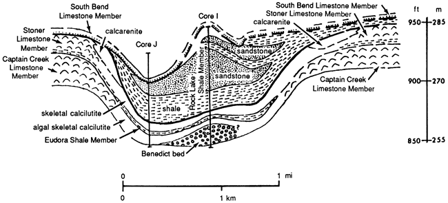
Algal-Mound Facies Belt--The Rock Lake shale ranges generally from 0.3 m to 0.9 m (1-3 ft) thick and is a sparsely fossiliferous shale over most of the algal-mound facies belt. In places, the Rock Lake Shale Member is absent and the overlying South Bend Limestone Member rests directly on the Stoner Limestone Member (Heckel, 1975b; Senich, 1978). In Woodson and Wilson counties contemporaneous channels (fig. 3) developed in the lower limestone members of the Stanton Limestone (Heckel, 1975b, 1978). These channels are filled with shales and sandstones of the Rock Lake Shale Member.
Across the Woodson County channel (fig. 5) the Rock Lake Shale Member ranges from 1.8 m to 22.5 m (6-74 ft) in thickness and consists mainly of light-gray to gray shale and buff to light-gray sandstone, which weathers rusty brown. The best exposures of this channel are in its northern part. Along the east side of a road cut in NW SW sec. 26, T. 25 S., R. 17 E., the Rock Lake Shale Member is a 6-m (20-ft) thick orange-brown quartz sandstone with crossbeds at the base. Wood fragments are abundant, and scattered echinoderm and mollusk molds are observed. Just to the southwest, 8.1 m (27 ft) of orange-brown crossbedded sandstone and limestone are exposed (Woodson County channel section; Moussavi-Harami, 1980, appendix C, section 22). The crossbedded skeletal calcarenite at the base, which contains fragments of echinoderms, brachiopods, and bryozoans along with interbeds of sandstone, is considered part of the Rock Lake depositional regime because quartz sandstone is unknown elsewhere in the Stoner Limestone Member (Heckel, personal communication, 1979). Along ditches in the road cut in the south line of SW sec. 3, T. 26 S., R. 17 E., 7.2 m (24 ft) of orange-brown crossbedded quartz sandstone carries many scattered plant fragments. Farther southwestward, along the creek near the south line of sec. 27, T. 26 S., R. 16 E., 2.4 m (8 ft) of the Rock Lake shale consists of dark-gray nonfossiliferous shale that grades upward into greenish-gray calcareous sandstone and siltstone.
Figure 5-Stratigraphic and facies relationships of Stanton Limestone across Woodson County channel projected from several exposures and cores near the western end [simplified from Heckel (1975a, p. 46)]. Datum is mean sea level. Vertical exaggeration is ≈40 times.
The only good exposure of the Rock Lake Shale Member along the northwestern rim of the algal-mound track (fig. 3) is along the bank of the Verdigris River at the low-water bridge southwest of Benedict (NE NE sec. 16, T. 28 S., R. 15 E.). There, 0.5 m (1.6 ft) of fossiliferous gray marine shale grades laterally into 0.9 m (3 ft) of buff to orange crossbedded sandstone with scattered clay pebbles, wood fragments, and a few marine fossil fragments. The channel-like sandstone thins toward the west and pinches out above limestone of the Stoner Limestone Member and below conglomeratic sand limestone of the South Bend Limestone Member.
Sandstone is poorly exposed all along the Wilson County channel (figs. 3 and 6). Much of the sandstone is gray to buff, fossiliferous, and conglomeratic and belongs to the South Bend Limestone Member (Heckel, 1975b). The Rock Lake Shale Member is mainly a noncalcarcous reddish weathering quartz sandstone up to 2.7 m (9 ft) thick. Crossbedding is conspicuous in places (e.g., SW sec. 7, T. 29 S., R. 16 E.). One of the best exposures of sandstone is in a small tributary to the Wilson County channel along K-47 (K-47 section; Moussavi-Harami, 1980, appendix C, section 28). At this locality the Rock Lake Shale Member is 1.8 m (6 ft) thick and consists of 7.5 cm (3 in.) of greenish-gray shale at the base overlain by orange-brown crossbedded sandstone, which cuts beds of the Stoner Limestone Member (fig. 7).
Figure 6-Stratigraphic and facies relationships within Stanton Limestone across Wilson County channel near Altoona. For locations see line AB in fig. 3 [simplified from Heckel (1975a, p. 46; 1978, p. 33)]. Datum is mean sea level. Vertical exaggeration is ≈40 times.
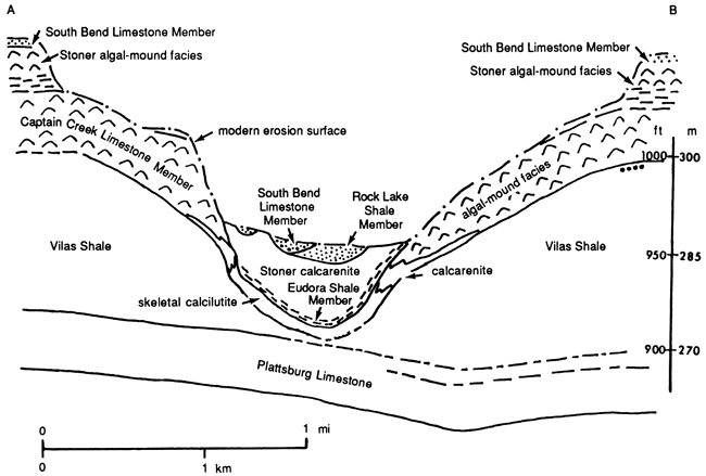
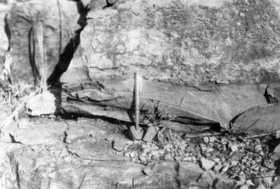
Figure 7--Crossbedded orange-brown sandstone of small tributary to Wilson County channel east of Fredonia. Channel sandstone, marked by 5-ft rod, cuts flat-lying beds of Stoner Limestone Member (left). K-46 section (Moussavi-Harami, 1980, appendix C, section 28).

Farther west in the subsurface, near where the Wilson County channel meets the northwestern rim of the mound tract, about 6 m (20 ft) of the Rock Lake Shale Member is present in core K (figs. 2 and 3). The lower portion of the Rock Lake shale in this core consists of interbedded buff to light-gray sandstone and dark-gray shale. The upper portion consists of buff to light-gray coarse-grained, crossbedded sandstone. Abundant but scattered plant fragments and scattered marine fossil fragments, such as echinoderms, are present.
Northeast of Elk City, 2.1 m (7 ft) of quartz sandstone is exposed in a roadbed near the north-central line of sec. 33, T. 31 S., R. 14 E. Lithologically, this sandstone is similar to that filling the channel in Wilson County, and it may fill a small low area in the Stoner mound in this region.
Near the south end of the algal-mound facies belt at the standard section of the Stanton Limestone, the Rock Lake Shale Member is 1.05 m (3.4 ft) thick. It consists of 0.6 m (2 ft) of fossiliferous gray shale overlain by 0.45 m (1.5 ft) of buff sandy shale and lenticular quartz sandstone with scattered pelmatozoan fragments (Heckel, 1975b).
Detrital Belt--Southward in the detrital belt, the Rock Lake Shale Member becomes much thicker and contains a greater variety of sandstones and shales. The northernmost exposure of Rock Lake sandstone in the detrital belt is in SW NW sec. 23, T. 32 S., R. 14 E., where it forms a cliff along Card Creek. At this locality, 5.1 m (17 ft) of orange-brown crossbedded sandstone is present beneath limestone of the South Bend Limestone Member. Just to the southeast, in the northeast side of Timber Hill along the road cut at the east-central line of NE sec. 26, T. 32 S., R. 14 E., the Rock Lake Shale Member is 3.3 m (11 ft) thick. The lower 2.7 m (9 ft) is nonfossiliferous gray shale that overlies the Timber Hill bed, and the upper 0.6 m (2 ft) is an orange-brown crossbedded sandstone.
Farther southwestward, the Rock Lake Shale Member thickens along US-160 to 8.4 m (28 ft) on the east side of Coon Creek and to 10.8 m (35 ft) on the west side in SE sec. 28, T. 32 S., R. 14 E. On the east side the lower 6 m (20 ft) is a tan nonfossiliferous shale that overlies the Timber Hill bed, and the upper 2.4 m (7.8 ft) is an orange-brown crossbedded sandstone. On the west side of the creek the shale thins to 5.1 m (17 ft), and the sandstone thickens to 5.7 m (19 ft) (Coon Creek section; Moussavi-Harami, 1980, appendix C, section 25). This sandstone unit thickens southward to the vicinity of Onion Creek in secs. 14, 15, 22, and 23, T. 33 S., R. 14 E., where it has been informally named the Onion Creek sandstone body by Heckel (1975b). Measurements for the present study show that the Rock Lake interval from the top of the Bolton bed (along the creek bottom in NE NE sec. 24, T. 33 S., R. 14 E.) to the top of the hill (along both sides of the road cut on the east side of secs. 22 and 27, T. 33 S., R. 14 E.) is 25.8 m (85 ft) thick (Onion Creek section; Moussavi-Harami, 1980, appendix C, section 20). At this locality the lower 11.7 m (38 ft) is mainly nonfossiliferous gray shale at the base, grading upward into interbedded gray shale and light-gray shale to yellowish-brown sandstone and siltstone. The upper part is 14.1 m (46 ft) of orange-brown crossbedded sandstone.
Southward along US-75 in the vicinity of Wayside between T. 33 S. and T. 34 S., the upper part of the Onion Creek sandstone thins and grades from more massive sandstone to very thin bedded, fine-gained sandstone or siltstone and shale that resembles the lower part of the Rock Lake Shale Member in T. 33 S.
Toward the south, in T. 34 S. and T. 25 S., two major facies of sandstone, described by Heckel (1975b), appear: massive to thick-bedded sandstone and thin-bedded sandstone with intercalated shale. Poor exposures make the relationship of these two facies difficult to ascertain. Heckel (1975b) suggested that the massive sandstones northwest and southwest of Tyro are stratigraphically higher than the thin-bedded sandstone and shale. This may be true in general, but the massive sandstones appear at different levels within the Rock Lake Shale Member.
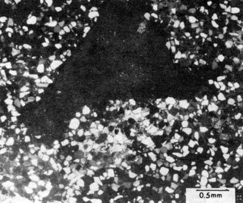
Two exposures display the two sandstone facies recognized by Heckel (1975b). The first outcrop is along a road cut on the north line of sec. 22, T. 34 S., R. 14 E., where 18.6 m (62 ft) of the Rock Lake Shale Member is exposed. The lower 15 m (49 ft) is predominantly greenish-gray shale. Within the shale a 1.5-m (5-ft) zone of thin-bedded, highly calcite-cemented sandstone occurs about 3 m (10 ft) above the base of the outcrop. Higher in this sequence the shale has been cut by 3.6 m (12 ft) of orange-brown crossbedded sandstone. The second outcrop occurs 0.8 km (0.5 mi) north of the Oklahoma border in road cuts along the west lines of NW sec. 14 and SW sec. 11, T. 35 S., R. 14 E. (Oklahoma border section), where 25.5 m (84 ft) of the Rock Lake Shale Member is exposed. At this locality, the lower 13.5 m (44 ft) are mainly gray shale with some interbeds of thin-bedded sandstone. The upper 12 m (39 ft) are orange-brown crossbedded sandstones (Moussavi-Harami, 1980, appendix C, section 3). Although Heckel (1975b) did not report fossils from these Rock Lake sandstone facies outcrops, scattered, abraded skeletal fragments of echinoderms, brachiopods, bryozoans, and pelecypods have been found in thin sections of the thin-bedded sandstone at these two localities (fig. 8).
Figure 8--Photomicrograph of echinoderm fragment (at extinction) in fine-grained, highly calcite cemented sandstone of Rock Lake Shale Member. Cross-polarized light. Sample R.3-4, Oklahoma border section (Moussavi-Harami, 1980, appendix C, section 3).
Westward along the Oklahoma border in secs. 16 and 17, T. 35 S., R. 14 E., a massive sandstone body supports two hills. Heckel (1975b) suggested that this body is either part of the Douglas Group that cut through the South Bend Limestone Member or a local thickening of a Rock Lake sandstone. Based on subsurface data, presented later, I believe that this body represents part of a major channel-sand deposit that formed during deposition of the Rock Lake Shale Member.
Poor exposures and a wide outcrop belt prevent accurate determination of the total thickness of the Rock Lake Shale Member from surface information in southern Montgomery County. By using regional dip and total relief between exposures, Heckel (1975b) suggested that the Rock Lake shale is at least 45 m (148 ft) thick and as much as 60 m (197 ft) thick in the vicinity of Cheyenne Creek in T. 34 S. (fig. 4) northeast of Caney.
Calcareous horizons within the Rock Lake Shale Member in the detrital facies belt have been described by Heckel (1975b). He assigned the informal names third oolite zone and fourth oolite zone to two of these horizons based on their stratigraphic positions above the Tyro oolite and Bolton bed in southern T. 33 S., T. 34 S., and T. 35 S. (fig. 4). The third oolite zone consists of sparsely fossiliferous oolitic sandstones that seem traceable along the outcrop. The fourth oolite zone includes a greater variety of fossiliferous oolitic sandstone and calcarenite and seems less easily traceable along the outcrop. Heckel (1975b) also described stromatolitic layers present in NW SE sec. 4, T. 35 S., R. 14 E., and in NW SE sec. 13, T. 33 S., R. 14 E. I discovered a 0.15-m (0.5-ft) thick bed of molluskan skeletal calcarenite in shale along the road cut in SE NE SE sec. 29, T. 34 S., R. 14 E. This limestone has not been recognized elsewhere, and it probably pinches out laterally within the shale.
South Bend Limestone Member
The South Bend Limestone Member is the uppermost member of the Stanton Limestone in eastern Kansas, and it can be traced into northern Oklahoma. The thickness of the South Bend limestone is 1.2-1.5 m (4-5 ft) across most of the mound tract, except in the Wilson County channel, where it is as thick as 4.5 m (15 ft) (Heckel, 1975a). The lower part is mainly a conglomerate or oolitic quartz sandstone, and the upper 0.6-1.2 m (2-4 ft) is predominantly a skeletal calcilutite. In northern Montgomery County, at the standard section of the Stanton, the South Bend limestone thickens to about 6 m (20 ft) and consists of 1.5 m (5 ft) of oolitic, conglomeratic quartzose limestone at the base that grades upward into 4.5 m (15 ft) of thick-bedded marine calcilutite with invertebrate and phylloid algae fossils.
Southward into the detrital facies belt along US-160 (Coon Creek section) and around Timber Hill, the South Bend Limestone Member thins to 1.2-1.5 m (4-5 ft) of yellowish- to orange-weathering skeletal calcilutite. The lower 0.3-0.6 m (1-2 ft) is a coarse-grained sandstone that is locally oolitic and conglomeratic and grades upward into skeletal calcilutite.
The contact between the South Bend Limestone Member and the Rock Lake Shale Member is sharp and erosional where the top of the Rock Lake is shale (Heckel, 1975b) and where conglomeratic quartz sandstone overlies the top of the Onion Creek sandstone (fig. 9). The contact seems to be gradational in other outcrops, such as along the road cut along the east line of NE sec. 26, T. 32 S., R. 14 E. The upper contact of the South Bend Limestone Member with fossiliferous shale of the Weston Shale Member (Sanger Formation) is sharp in both the algal-mound and detrital facies belts.
Figure 9--Sharp contact between conglomeratic quartz sandstone of South Bend Limestone Member (above pen) and smooth brown sandstone of Rock Lake Shale Member (behind pen) at Coon Creek section along US-160 (Moussavi-Harami, 1980, appendix C, section 25).
Subsurface stratigraphy in the detrital facies belt
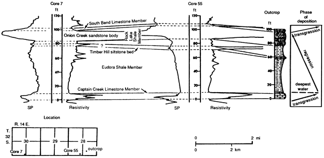
I used electric logs and drillers' logs furnished by the Kansas Geological Survey to construct a series of maps and cross sections of the Stanton interval in the near subsurface of western Montgomery and eastern Chautauqua counties (fig. 2). Neither drillers' logs nor lithology logs were available for any of the wells for which electric logs were available. Therefore I interpreted rock types in wells by comparing the exposed outcrop sequences with electric-log signatures in nearby wells (fig. 10). Four different types of rock can be identified on the electric logs [based on resistivity and spontaneous potential (SP) signatures]: limestone, sandstone, shale, and mixed rock. Mixed rock is interpreted as a mixture of silty shale and shaly sandstone.
Figure 10--Relationship between different rock umts of Stanton Limestone in outcrop (Coon Creek section) and nearby electric logs. Distance between outcrops and electric logs not to scale. Datum is base of Captain Creek Limestone Member.
Structure
I constructed a structural contour map (fig. 11) for the top of the South Bend Limestone Member, which is the most easily traced unit in the subsurface. The map indicates that strata in this part of Kansas dip generally toward the west about 5 m/km (26.5 ft/mi), as previously demonstrated on surface exposures by Heckel (1975b) and in the subsurface by Winchell (1957b, plate 2B). An anticlinal structure in the south end of the algal-mound facies belt probably is related to the topography of the South Bend mound (Heckel and Cocke, 1969, p. 1073). Three major anticlinal structures are shown west of the outcrop in the detrital facies belt. One, in the southwestern part of T. 32 S., R. 14 E., is possibly related to thickening of the Onion Creek sandstone in this area. Whether the other two structures (southeastern part of T. 32 S., R. 12 E., and west-central part of T. 33 S., R. 13 E.) are related to thickening of sandstone bodies within the Rock Lake Shale Member is not certain because of insufficient data. However, no anticlinal structure is present to the south (T. 34 S., R. 13 E.), where a thick sandstone body is known in the subsurface.
Figure 11-Structural contour map (in feet) on top of South Bend Limestone Member of Stanton Limestone in southern Kansas. Datum is mean sea level.
Thickness
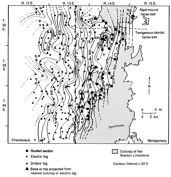
The thickness of subsurface Stanton Limestone in the detrital facies belt ranges from less than 27 m (89 ft) to as much as 54 m (177 ft) (fig. 12). It is more than 48 m (157 ft) thick at the south end of the algal-mound facies belt, where most of the unit is limestone. The Stanton Limestone thins southward to 27 m (89 ft) locally in the northern part of the detrital facies belt (southern T. 32 S. and T. 33 S.). It is locally more than 33 m (108 ft) thick in the southwestern part of T. 32 S., R. 14 E.; this may be related to thickening of the Onion Creek sandstone, as seen in outcrops to the east. The Stanton Limestone thickens southward to more than 54 m (177 ft) in T. 34 S. because of thickening of the Rock Lake sandstones, one of which cuts through the lower members of the Stanton Limestone in this area. Further southward thinning of the Stanton Limestone in T. 35 S. probably relates to thinning of the Rock Lake sandstone and southward replacement mostly by shale of the Eudora-Rock Lake interval, as exposed in new road cuts north and west of Copan, Oklahoma (Heckel, personal communication, 1980).
Figure 12--Net isopach map (in feet) of Stanton Limestone in southern Kansas. Interval shown lies between base of Captain Creek Limestone Member, Tyro bed, or sandstone cutting through Tyro bed and top of South Bend Limestone Member.
Sandstone distribution
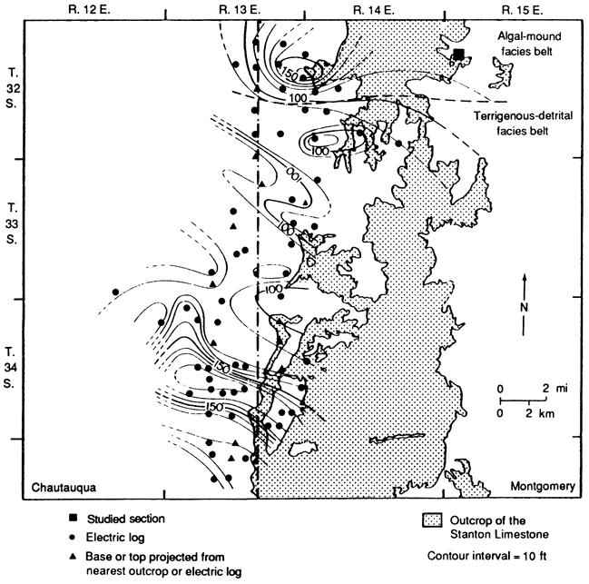
A new sand isolith map of the Rock Lake Shale Member (fig. 13) indicates two major sandstone areas: one in T. 33 S., with a thickness of more than 15 m (49 ft) [the Onion Creek sandstone body of Heckel (1975b)], and the other in T. 34 S., with a thickness of more than 24 m (79 ft), as yet unnamed. Both major sandstone areas and adjacent lobes have a southeast-northwest alignment, thinning toward the northwest.
Figure 13--Net sand isolith map (in feet) of Rock Lake Shale Member of Stanton Limestone in southern Kansas. Distribution of sandstone in outcrop is modified slightly from Heckel (1975b) (see also fig. 14).
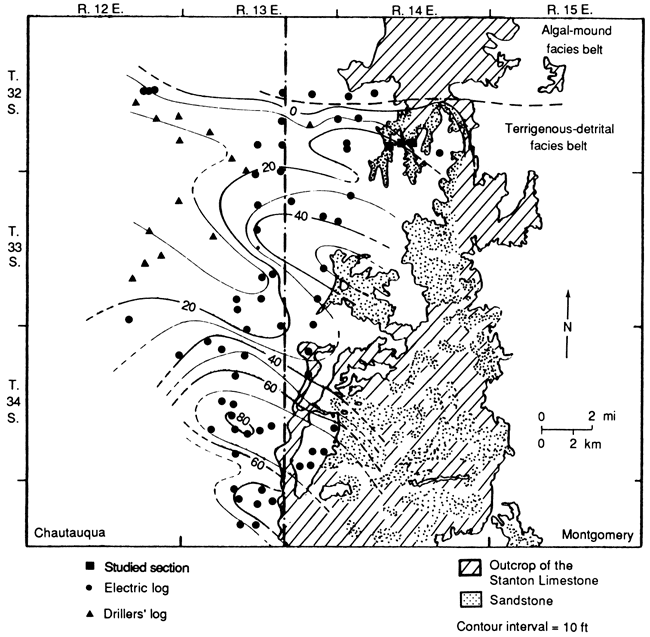
The Onion Creek sandstone thins northward and disappears at the boundary between the detrital facies belt and the algal-mound facies belt where the limestone units of the Stanton Limestone thicken abruptly northward. Both lobes of the subsurface Onion Creek sandstone in T. 32 S.and T. 33 S. reflect local thickening of the exposed Onion Creek sandstone in this area. Southward the Onion Creek sandstone thins from more than 15 m (49 ft) to 3 m (10 ft) in southern T. 33 S.
The major sandstone area in T. 34 S., which comprises upper and lower sandstone bodies in wells 134 and 138 (fig. 14), probably includes much of the exposed sandstone in southern Montgomery County. It aggregates more than 24 m (79 ft) in T. 34 S. and thins northward to less than 9 m (30 ft) toward the Onion Creek body. It thins southward to 15 m (49 ft) before thickening southern lobe in T. 35 S. This southern lobe is related to thickening of only the upper sandstone in wells 134 and 138 in the southern detrital belt (fig. 14). The sandstone then thins southward into Oklahoma, and little is seen in the Stanton Limestone interval exposed around Copan.
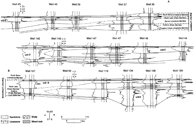
Figure 14--Subsurface correlation of the Stanton Limestone in the detrital facies belt. Datum is the base of the South Bend Limestone Member. Lettered units refer to described sandstone units in the Rock Lake Shale Member. [An Acrobat PDF verion of the cross section image is available.]
Stratigraphy
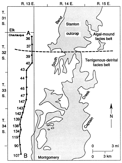
A north-south cross section (fig. 14) was constructed along the subsurface strike of the Stanton Limestone in eastern Chautauqua County about 3-8 km (2-5 mi) west of the outcrop. Correlation is mainly lithostratigraphic, and the easily recognized base of the South Bend Limestone Member is used for the datum.
The subsurface cross section closely reflects the major facies changes observed in the outcrop. The two northernmost wells (36 and 37) penetrate a Stanton interval dominated by carbonate rock in the south end of the algal-mound facies belt. The southern 15 wells (39 to 107) penetrate a Stanton interval dominated by sandstone and mixed rock, with several individual sandstone bodies evident (units A-E, fig. 14). All outcropping members of the Stanton Limestone were recognized on the subsurface cross section.
The Captain Creek Limestone Member thins from 13.5 m (44 ft) in the algal-mound facies belt to 3.6 m (12 ft) southward into the detrital facies belt, just as it does along the outcrop. It can be traced with no difficulty southward through T. 32 S. Wells 43, 44, and 46 apparently do not penetrate far enough to identify the Captain Creek limestone in northern T. 33 S. The Captain Creek Limestone Member is recognized in southern T. 33 S. as 0.9 m (3 ft) of limestone in wells 47 and 147, but the next two wells southward (143 and 142) in northern T. 34 S. do not indicate limestone. Just to the south, however, a higher resistivity value at this horizon in well 139 may indicate the appearance of the Tyro oolite, which crops out eastward at about this latitude. (If the low resistivity and SP values in wells 142 and 143 are related less to facies change than to changes in porosity and chemical fluid within the rock unit, then the Captain Creek Limestone Member may be continuous with the Tyro oolite in this area without intervening shale or siltstone. In the absence of enough information to evaluate this subsurface data, the outcrop data is assumed to provide the best interpretation for the Captain Creek-Tyro relationship in the subsurface.) Southward the Tyro oolite can be traced in the subsurface to the Oklahoma border, as it can in the outcrop, except in the middle of T. 34 S. (wells 138 and 134), where the southern thick sandstone unit (A) of the Rock Lake Shale Member cuts both the Eudora Shale Member and the Tyro oolite.
Good resolution on electric logs allows the Eudora Shale Member to be identified with little difficulty. It ranges from 0.9 m to 1.8 m (3-6 ft) in thickness between two limestones in the south end of the algal-mound facies belt. Southward into the detrital facies belt, the Eudora Shale Member thickens to 6 m (20 ft) in well 39 and to 9 m (30 ft) in well 40. Although wells 43, 44, and 46 do not penetrate the entire Eudora shale, it is at least 2.4-6 m (8-20 ft) thick in northern T. 33 S. It thins to 1.5 m (5 ft) in well 47, where the underlying Captain Creek Limestone Member reappears, and it retains this thickness to the Oklahoma border, except where it is cut by Rock Lake sandstone in wells 134 and 138 in T. 34 S. The general pattern of southward thinning of the Eudora Shale Member is also seen in the outcrop, where thick gray shale overlies black shale in the north and thinner dark-gray shale occurs to the south.
The Stoner Limestone Member is found only in wells 36 and 37 at the south end of the algal-mound facies belt. It thins and disappears southward into mixed rock of the Rock Lake Shale Member and shale of the Eudora Shale Member as it does in the outcrop.
The Rock Lake Shale Member in well 36 in the algal-mound facies belt is about 3 m (10 ft) of mixed rock. It begins thickening southward to 7.2 m (24 ft) in well 37 at the south end of the algal-mound facies belt and reaches 15-51 m (49-167 ft) thick in the detrital facies belt, where it consists predominantly of sandstones and mixed rock. Five different sandstone units can be recognized in the subsurface Rock Lake Shale Member (fig. 14) in the detrital facies belt. They are described, partly in ascending stratigraphic order, in what follows.
Unit A, a thick sandstone, occupies the lower part of the Stanton Limestone in T. 34 S. where its central part cuts the Eudora Shale Member and Tyro oolite in wells 134 and 138. It grades upward into alternating sandstone and mixed rock. Abrupt changes of resistivity and SP values within the sandstone unit suggest occasional lenses of shale within the sandstone, as seen in outcrops. Unit A thins southward from 34 m (112 ft) in well 134 to 17.4 m (57 ft) in well 90 and is replaced by mixed rock in well 107 near the Oklahoma border. It also thins northward (well 139) and may correlate with the lower part of sandstone unit D in well 142. Unit A is possibly an extension of the thick sandstones low in the Stanton Limestone exposed along Cheyenne Creek in T. 34 S., R. 14 E., and the massive crossbedded sandstone exposed in the top of the Tyro quarry (Moussavi-Harami, 1980, appendix C, sections 8 and 9). Stratigraphically, this thick sandstone unit is the oldest major sandstone within the Stanton Limestone.
Unit B (fig. 14) is best developed in wells 107 and 90 in T. 35 S., where it is 10.5-15 m (34-49 ft) thick. It overlies mixed rock, which in well 90 lies above unit A. It is overlain by a thin sequence of mixed rock below the South Bend Limestone Member. Unit B thins northward and is replaced by mixed rock and thin sandstone of unit C. Unit B is possibly an extension of the exposed thick sandstone body that forms the two hills north of the Oklahoma border in secs. 16 and 17, T. 35 S., R. 14 E. This unit is definitely younger than unit A and is probably older than most of unit C in wells to the north.
Unit C is a rather thin sandstone [7 m (23 ft)] that formed at the top of the Rock Lake Shale Member above unit A in T. 34 S. It is directly overlain by the South Bend limestone and thus is stratigraphically the highest and probably the youngest sandstone unit formed in this part of the detrital facies belt. It is likely that unit C formed from northward shifting of the sand sources responsible for unit B and perhaps from southward shifting of the sand sources responsible for unit D (well 142).
Unit D is a thick sandstone (fig. 14) and is apparent only in well 142. It thins from 21 m (69 ft) both southward and northward, into alternating sandstone and mixed rock. The presence of a thin sequence of mixed rock at the top of unit D indicates that this unit probably formed at roughly the same time as unit B to the south but before unit C. Although unit D is stratigraphically higher and mostly younger than unit A, the lower part of unit D may be equivalent to the upper part of unit A. This suggests that unit D may have formed by northward shifting of the major sand source responsible for unit A. Although unit D is not definitely recognized in outcrops, it is replaced northward in the subsurface by alternating thin lenses of sandstones and mixed rock, possibly the thin interbedded shale and sandstone seen in outcrops along US-75 east of Wayside at about this latitude.
Unit E, up to 13.5 m (44 ft) thick, is present at the top of the Rock Lake Shale Member beneath the South Bend Limestone Member farther north in northern T. 33 S. and southern T. 32 S. This is probably the eastern subsurface extension of the Onion Creek sandstone. The absence of mixed rock between this sandstone and the overlying South Bend Limestone Member suggests that unit E and unit C are the youngest sandstones in the Rock Lake Shale Member and that they formed at roughly the same time. (Although some drillers' logs indicate that unit E is replaced by a thick sequence of limestone between T. 32 S. and T. 33 S., it is likely that these particular drillers mistook Stanton chips for limestone because some drillers' logs show limestone next to outcropping sandstone.) The lower part of the Rock Lake Shale Member in T. 32 S. and T. 33 S. is primarily mixed rock, possibly silty shale, as seen in outcrop along US-160.
The South Bend limestone is easily recognized in all wells in the cross section (fig. 14), marking the top of the Stanton-Rock Lake interval throughout the detrital facies belt in Kansas. It thins from 7.5 m (25 ft) in well 36 (probably algal-mound facies as in outcrops) southward in T. 32 S. to 1.2-1.5 m (4-5 ft), just as it does at this latitude along the outcrop. It rests directly on Rock Lake unit E (Onion Creek sandstone) in southern T. 32 S. and northern T. 33 S., on unit C in central T. 32 S., and on mixed rock of the Rock Lake Shale Member elsewhere. The South Bend Limestone Member is overlain conformably by the Weston Shale Member of the Stranger Formation. Although Winchell (1957a,b) reported an erosional unconformity between the Tonganoxie Sandstone Member of the Stranger Formation and the Lansing Group (Stanton Limestone) in south-central Kansas, Ball (1964) noted that the erosional unconformity at the base of the Tonganoxie member in northeastern Kansas is not continuous and that the Weston shale rests conformably on the South Bend limestone in southern Kansas. Present subsurface tracing of the South Bend Limestone Member across the detrital belt supports Ball's (1964) interpretation.
The Timber Hill, Rutland, and Bolton beds are difficult to recognize in the subsurface (fig. 14). These thin siltstone and limestone beds either pinch out westward into Rock Lake sandstone and shale or become too thin to be resolved by logging tools. Figure 10, however, indicates that the Timber Hill bed can be detected up to 3.2 km (2 mi) west of its outcrop in the electric logs of wells 55 and 7. Where these beds are not recognized in the subsurface in the detrital facies belt, the Eudora Shale Member is differentiated from the Rock Lake Shale Member as a basal shale in a sequence that grades upward into mixed rock and sandstone.
Calcareous zones, such as the third and fourth oolites, exposed along the outcrop in southern Montgomery County, also were not recognized in the subsurface. Although some high resistivities on logs in the southern part of the detrital facies belt might be interpreted as calcareous, they lack sufficient continuity to be interpreted as marker horizons. Thus they probably represent low-porosity calcite-cemented sandstones similar to those observed at various stratigraphic levels in the outcrops.
Prev Page--Introduction || Next Page--Petrographic analysis
Kansas Geological Survey, Geology
Placed on web Nov. 4, 2010; originally published 1990.
Comments to webadmin@kgs.ku.edu
The URL for this page is http://www.kgs.ku.edu/Publications/Bulletins/GS5/03_strat.html