![]()
Prev Page--Contents || Next Page--Stratigraphy
Introduction
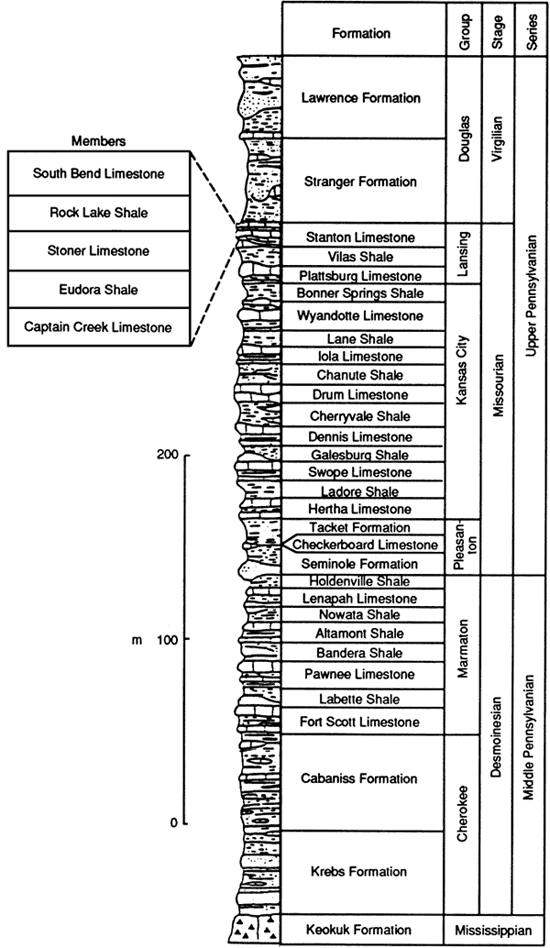
The rocks of the Missourian Stage of the Upper Pennsylvanian series in midcontinent North America are primarily alternating limestones and shales (fig. 1) with local lenticular sandstone bodies, particularly in southeastern Kansas. Several of the limestone formations have been studied in detail (Crowley, 1969; Mossler, 1973; Frost, 1975; Mitchell, 1981; Ravn, 1981), and some of the shale units were studied by S. R. Schutter (1983). The Stanton Limestone in particular has been the subject of detailed stratigraphic, petrologic, and paleontologic studies (Heckel, 1975a,b, 1978; Heckel et al., 1979; Senich, 1975,1978; Wood, 1977; Malinky, 1980). The Stanton Limestone has five members, in ascending order: the Captain Creek Limestone Member, the Eudora Shale Member, the Stoner Limestone Member, the Rock Lake Shale Member, and the South Bend Limestone Member (fig. 1). The Rock Lake Shale Member is predominantly a thin shale in the north but contains several quartz sandstone units toward the south; it includes most of the sandstone known in the upper Missourian north of Oklahoma.
Figure 1--Position of Stanton Limestone and Rock Lake Shale Member in Upper Pennsylvanian sequence of Kansas [modified from Heckel (1978)].
Geologic setting
The Stanton Limestone is the youngest unit of the Missourian Stage (Upper Pennsylvanian) in the central United States and is recognized from eastern Nebraska to southern Iowa, northwestern Missouri, eastern Kansas, and northern Oklahoma (Heckel, 1975a; Heckel, personal communication, 1981). It overlies the Vilas Shale and underlies the Weston Shale Member of the Stranger Formation (Douglas Group, Virgilian Stage). In eastern Kansas these strata dip gently toward the west and northwest (fig. 2) at approximately 5 m/km (26.5 ft/mi). The outcrop region extends from the Forest City basin across the Bourbon arch into the northern end of the Cherokee platform, all of which were relatively stable during the late Missourian (Moore, 1979).
Figure 2--Study area showing Stanton Limestone outcrop (between dashed lines), Rock Lake sandstone outcrops (stippled), and three facies belts of Heckel (1975b). Shaded area locates subsurface extent of study.
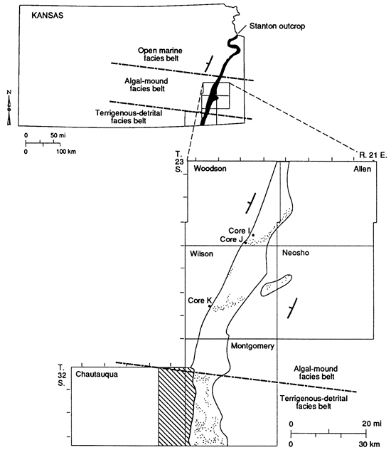
Outcrops of the Stanton Limestone in eastern Kansas represent three different facies belts. From north to south they are the open-marine, the algal-mound, and the terrigenous-detrital (Heckel, 1968, 1975a,b, 1977; Heckel and Cocke, 1969). Most of the sandstones are in the terrigenous-detrital facies belt, but some occur in channels in the algal-mound facies belt (fig. 2). In the open-marine facies belt of northeastern Kansas, the members of the Stanton Limestone are 10.5 m (34.4 ft) thick and can be traced laterally to northern Anderson County with little change (Heckel and Cocke, 1969). Southward in the algal-mound facies belt, in northern Montgomery County, the limestone members of the Stanton Limestone thicken into algal-mound facies, reaching a thickness of 35 m (115 ft). Southward in the terrigenous-detrital facies belt the limestones thin abruptly to only a meter in thickness and the shale members thicken substantially.
Heckel (1975b, 1977, 1978) and Heckel and Baesemann (1975) described in detail the major transgressive-regressive (cyclothemic) sequence of the Stanton Limestone and other Middle and Upper Pennsylvanian formations in Kansas. The Stanton Limestone in eastern Kansas is one complete cyclothem (Captain Creek-Eudora-Stoner) and the beginning of another cycle (South Bend). These mostly marine parts of the cycles are separated by the Rock Lake Shale Member, which was deposited mainly during the regressive phase between the two inundations.
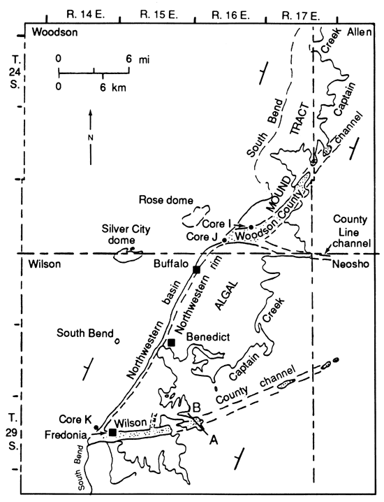
The Rock Lake Shale Member of the Stanton Limestone [0.9-4.3 m (3-14 ft) thick] is predominantly shale in northeastern Kansas. It thins southward over most of the algal-mound facies belt (fig. 3) to 0.3-0.6 m (1-2 ft) but thickens locally to 21 m (70 ft) with a large addition of sandstone within paleochannels in this region. It thickens regionally and includes strata equivalent to the underlying Stoner Limestone Member as it grades largely into sandstone southward in the terrigenous-detrital facies belt, where it reaches 25.8 m (85 ft) in thickness in T. 33 S., R. 14 E., and 54 m (177 ft) in the subsurface of T. 34 S., R. 12 E. and R. 13 E.
Figure 3--Outcrop of Stanton Limestone in algal-mound tract of Woodson and Wilson counties showing locations of cores I, J, and K. Rock Lake sandstone outcrops in channels are shown by stippled pattern [modified from Heckel (1975a, p. 45; 1978, p. 28)].
Previous work
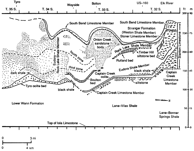
Stratigraphic work on the Stanton Limestone in the detrital facies belt has been reviewed by Heckel (1975b, p. 7). Until the work of Wilson (1957a,b), a large portion of the sandstone and shale in the detrital facies belt in western Montgomery County was misidentified as post-Stanton (Schrader, 1908; Geologic map of Kansas, 1964; Oakes, 1940). Although Winchell (1957a) assigned exposures along US-160 of what is now called the Onion Creek sandstone body (Heckel, 1975b) to the lower part of the South Bend Limestone Member of the Stanton Limestone, he nevertheless mapped most sandstones and shales of the Rock Lake Shale Member in southern Montgomery County as post-Stanton (Winchell, 1957b, plate 2B).
Heckel (1975b) mapped in detail and established a stratigraphic correlation (fig. 4) of the outcropping Stanton Limestone in the detrital facies belt, naming several discontinuous lenses of limestone and siltstone as beds (Tyro, Rutland, Bolton, Timber Hill). The Tyro bed was considered by both Wilson (1957a,b) and Heckel (1975b) to be equivalent to the Captain Creek Limestone Member. The Rutland, Bolton, and Timber Hill beds were considered the Stoner Limestone Member by Wilson (1957a,b), and Heckel (1975b) interpreted the Timber Hill and Rutland beds as equivalent to the upper Stoner limestone and the Bolton bed as equivalent to the lower Stoner limestone. These three units by definition separate the Eudora Shale Member below from the Rock Lake sandstone and shale above. In southern Montgomery County, where the Bolton bed pinches out into clastics, separation of the Eudora Shale Member from the Rock Lake Shale Member is made at the base of the lowest coarse detrital bed above the Tyro bed. On the south side of the Tyro quarry, about 1 m (3.3 ft) of conglomeratic quartz sandstone defines the base of the Rock Lake Shale Member.
Figure 4--Generalized cross section showing subdivisions and facies of Stanton Limestone along outcrop across terrigenous-detrital facies belt in Montgomery County, Kansas [simplified from Heckel (1975b, p. 8)].
In their reconnaissance studies, Wilson (1957a,b), Kenny (1968), and Heckel (1975a,b, 1977, 1978) suggested that the Rock Lake Shale Member can be attributed to a deltaic regime. On the other hand, Harbaugh (1962) suggested that the detrital sediments in the Stanton Limestone may have been deposited in a meandering stream system with a southerly source.
Purpose of investigation
The purpose of this study is to determine the nature and origin of siliciclastic sandstones in the predominantly carbonate cratonic setting of the Stanton Limestone in southeastern Kansas. Although earlier researchers suggested generalized environments for these rocks, no one has ever done a detailed study of the sandstone units. The procedures and results of this study should provide guidelines for future studies of cratonic-shelf siliciclastic paleodepositional systems by establishing and evaluating field and laboratory techniques that are useful in dealing with these systems and by developing a process-response model that can be used as a working hypothesis for the analysis of similar rock sequences elsewhere in the midcontinent.
Method of investigation
I conducted field investigations during the summers of 1978 and 1979 and the fall of 1979, measuring and describing in detail exposures of sandstones within the Stanton Limestone in southeastern Kansas. I paid particular attention to vertical textural and compositional changes and to contact relations of individual beds. Because of poor exposure of sandstones in the study area, I was not able to trace beds laterally between outcrops.
I sampled each exposure of the Stanton Limestone in detail. I used epoxy resin to impregnate samples in the laboratory before thin sectioning them because most of the sandstone samples were friable. I studied more than 150 thin sections petrographically to ascertain the composition of sandstones and to interpret diagenetic history and provenance of the grains. I analyzed textures (e.g., grain size) of sandstone and siltstone units by using the loose-grain technique of Griffiths (1967) and determined mean grain sizes from samples collected at 9 selected measured sections of the Stanton Limestone (88 samples) by measuring the maximum diameter of 50 monocrystalline quartz grains in each sample. I chose monocrystalline quartz because it is the most abundant and stable mineral component present in these rocks. Although petrographic measurements of detrital quartz grains cannot be used in statistical analyses because of diagenetic alteration of absolute grain sizes, relationships between relative grain sizes and sedimentary structures can be used to approximate energy conditions during deposition (Harms and Fahnestock, 1965).
I measured the azimuth of sedimentary structures, such as cross-stratification and ripple marks, in the field. Because these rocks have a structural dip of less than 1°, rotation corrections were not warranted. I plotted the measurements on a circular histogram and used the vector mean to interpret paleocurrent directions. Because of poor exposure, the number of measurements taken ranged from 1 to 20 for each exposure. Although this number of measurements does not allow for statistical interpretations, these measurements in conjunction with thinning of the sandstones units in the Stanton Limestone (derived from subsurface information) can be used to make convincing interpretations of the directions of sediment transport.
One-hundred twenty-three electric logs and numerous drillers' logs from wells that either completely or partially penetrate the Stanton Formation were made available by the Kansas Geological Survey. I used all the electric logs, the outcrop descriptions, and many of the drillers' logs to generate data for construction of a structural contour map for the top of the South Bend Limestone Member of the Stanton Limestone. I constructed an isopach map from 74 electric logs that penetrate the entire formation and outcrop descriptions and a net sand isolith map from 62 electric logs in conjunction with drillers' logs and outcrop information. Some drillers' logs seemed unreliable (e.g., sandstones and limestones were not differentiated) and therefore were not used. Unfortunately, neither drillers' logs nor cutting logs were available for any of the electric logs. This necessitated the use of nearest outcrop data and generalized log signature [i.e., those suggested by Pirson (1977)] to interpret the relationships between well-log signatures and Stanton formation lithologies in the subsurface. The spontaneous potential and the resistivity curves were the only logs available for lithologic correlation purposes.
The spontaneous potential logs measured natural potential of rock units and potential between mud filtrate and connate fluid. The resistivity logs measured the voltage of the current passed through the formation from certain electrodes (Pirson, 1977).
P. H. Heckel obtained three cores from Wilson and Woodson counties as part of the Kansas Geological Survey drilling program (fig. 2). 1 examined these cores, along with samples from three cores supplied by the Trico Production Company in northeastern Chautauqua County, in detail, comparing lithic sequence, texture, and sedimentary structure in the cores to those in surface exposures. I used these comparisons, together with the geographic position of cores, to interpret subsurface stratigraphy in areas where outcrops are not available and to evaluate the diagenetic history by thin-section study of samples unaffected by present surface weathering conditions.
Prev Page--Contents || Next Page--Stratigraphy
Kansas Geological Survey, Geology
Placed on web Nov. 4, 2010; originally published 1990.
Comments to webadmin@kgs.ku.edu
The URL for this page is http://www.kgs.ku.edu/Publications/Bulletins/GS5/02_intro.html