![]()
Prev Page--Igneous and Metamorphic || Next Page--Paleozoic--Pennsylvanian System
Paleozoic Rocks
The outcropping consolidated rocks throughout most of eastern and central Kansas are all sedimentary strata of Late Paleozoic age. They include shale, sandstone, limestone, and conglomerate having widely varied characteristics, as well as coal beds, dolomite, and some other rock types. Paleozoic rocks underlie all of western Kansas. Locally exposed igneous rocks in Woodson and Riley Counties may be Paleozoic but they are probably much younger. The total thickness of exposed Paleozoic rocks in Kansas, derived by compiling average measurements of recognized subdivisions, may be given as approximately 6,000 feet.
Surface distribution and structure--The eastern and south-central parts of Kansas contain extensive outcrops of Upper Paleozoic rocks, chiefly Permian and Pennsylvanian. This is a region of roughly parallel belts of plains which are developed on the outcrops of weak rocks and on the upper surface of some gently inclined hard formations. The plains are separated by hilly country which terminates eastward in a more or less prominent escarpment. The general trend of these escarpments is south-southwest across eastern Kansas. The Flint Hills, which are formed by Lower Permian strata, are an example.
At the outcrop, Paleozoic strata in Kansas show a very gentle west or west-northwest dip. It ranges mostly from 15 to 35 feet to the mile. Locally, there are dips in other directions or the layers may be quite horizontal; nowhere are the strata steeply inclined. A noteworthy belt of distinct, although gentle, easterly dips may be traced across the State from the vicinity of Arkansas City in the south to the neighborhood of Seneca in the north; this defines the east limb of an anticlinal structure which overlies the buried Nemaha anticline. Drilling along this anticline in south-central Kansas has led to the discovery of important oil and gas fields. Faults having small displacement are observed in a few places, but nowhere in Kansas is faulting a very noticeable feature of the rock structure.
Subsurface distribution and structure--In the subsurface, the Permian rocks underlie all of Kansas west of their outcrops in the central part of the State. Except for a few square miles in the southeastern corner of Kansas where Mississippian formations are exposed, Pennsylvanian rocks blanket the State. The lower parts of the Pennsylvanian sequence locally are missing on account of overlap of deposits on pre-Pennsylvanian topographic features, and the upper parts in eastern Kansas have been removed by erosion. Like the outcrops, the Pennsylvanian and Permian rocks in the subsurface generally dip northwestward, but the formations flatten in western Kansas and at the Colorado line they dip eastward.
Mississippian rocks were also originally coextensive with the State, but they were eroded from the Central Kansas uplift and the northern end of the Nemaha anticline before Pennsylvanian deposition began in Kansas. Devonian and Silurian rocks (Hunton) and Upper Ordovician rocks were originally more widely distributed in the State than now, but like the Mississippian, their limits have been greatly restricted by pre-Pennsylvanian and earlier periods of erosion and they are now confined to northeastern Kansas. Rocks of Middle Ordovician age, representing the Viola limestone and the Simpson formation of Oklahoma, still blanket the State except on higher parts of the Central Kansas uplift, on the northern end of the Nemaha anticline, and on the Chautauqua arch. Some formations of the Arbuckle group (Lower Ordovician and Upper Cambrian) were originally deposited throughout Kansas, but they have been removed from parts of the Central Kansas uplift and the northern end of the Nemaha anticline. Owing to structural and erosional events during the deposition of the Arbuckle sequence, the Arbuckle formations are very irregularly distributed.
All the pre-Pennsylvanian formations participated in the structural movements that deformed the Pennsylvanian and younger rocks. The pre-Pennsylvanian and especially the pre-Mississippian rocks, however, had already sustained structural deformations at variance with the later movements which have resulted in some areas of marked discordance between the regional structure at the surface and in the subsurface.
Permian System
Character and surface distribution--Rocks of Permian age which occur in Kansas include evenly stratified predominantly marine deposits in the lower part of the section and irregularly bedded, mainly nonmarine deposits in the upper part. Light ash-gray to cream-colored limestone beds, many of which are distinguished by abundance of flinty chert, form persistent benches or escarpments, among which the so-called Flint Hills are most prominent. The Flint Hills extend across Kansas from Nemaha County on the Nebraska border to western Chautauqua County adjoining the Oklahoma boundary. The escarpments are east-facing because the gentle regional dip of the Permian strata is westward. Between the limestone formations and members of the Lower Permian are gray, green, and red shale units, in part containing marine fossils and in part representing nonmarine sedimentation. Sandstone is virtually absent in this part of the section.
Middle and upper parts of the Permian succession consist mainly of shale and sandstone, many of them red in color. Thick deposits of salt which occur do not crop out, because the Kansas climate is not arid enough to allow such soluble rock to be exposed at the surface. Gypsum beds, some of minable thickness, may be seen, however, and a few thin but persistent dolomites occur in the redbeds part of the Permian section.
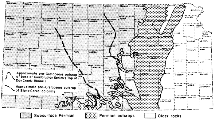
The outcrops of Permian rocks in Kansas form a belt extending from Washington, Marshall, Nemaha, and Brown counties on the northern boundary to Meade, Clark, Comanche, Barber, Harper, Sumner, and Cowley counties on the Kansas-Oklahoma line (Fig. 14). The total outcrop thickness is about 3,000 feet.
Figure 14--Distribution of Permian rocks in Kansas.
Subsurface distribution and character--Permian rocks underlie all of Kansas west of the outcrop belt. They are covered unconformably by Triassic (?) rocks locally near the southwestern corner of the State, by Jurassic in the subsurface of some northwestern counties, and elsewhere by Cretaceous, Tertiary, and Quaternary formations. Maximum thickness is attained in the Hugoton basin. The Lower Permian section is somewhat thinner, but not greatly below average, above the Central Kansas uplift.
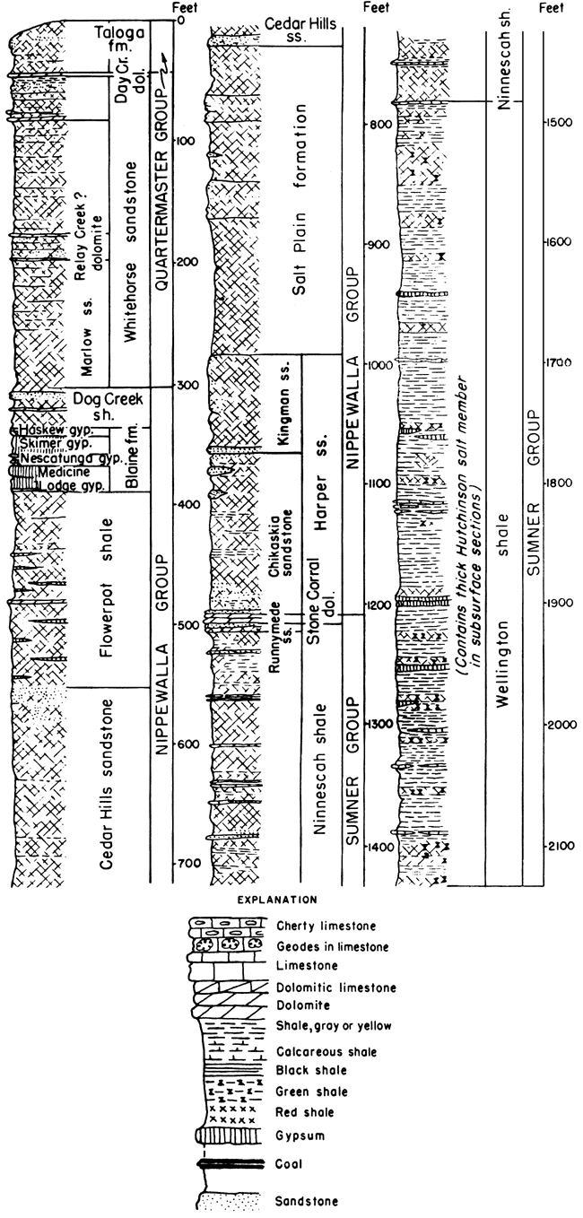
The structure of buried Permian rocks in Kansas is broadly synclinal, except where formations of the system overlie the Nemaha buried ridge. The axis of the broad syncline trends slightly west of northward across the western third of the State and it plunges gently northward (Fig. 46). The prevailing dip of Permian strata is westward or northwestward from the outcrop belt to the trough of the Hugoton embayment in Meade and Seward counties and the synclinal axis trending northward to Decatur County. Eastward dips are found in westernmost Kansas. Upper Permian rocks (Guadalupian Series) comprise red shale (Taloga) at the top, dolomite (Day Creek) which grades westward into anhydrite and gypsum, and red siltstone and sandstone (Whitehorse) at the base. The series is 460 feet thick in Morton County (Taloga, 160 feet; Day Creek, 20 feet; Whitehorse, 280 feet). It thins northward to only 19 feet of red silty sandstone and shale (Whitehorse) in Wallace County.
The middle part of subsurface Permian deposits in Kansas (Leonardian Series) consists predominantly of red shale and sandstone grading downward into gray shale. Gypsum occurs at the top, a persistent dolomite near the middle, and thick salt near the base. Leonardian strata attain a thickness of about 2,000 feet in southwestern Kansas. So far as known, the Leonardian rocks are conformable with overlying and underlying Permian strata.
Upper Leonardian (Nippewalla) rocks include red shale (Dog Creek), gypsum (Blaine), and alternating red shale and sandstone; this division thickens southward from about 400 feet in Wallace, Logan, and Gove counties to more than 800 feet in Stevens and Meade counties. The Dog Creek-Blaine part of the succession increases westward from 50 feet in eastern sections to 200 feet at the Colorado border.
Lower Leonardian (Sumner) rocks comprise dolomite (Stone Corral), red shale (Ninnescah), and predominantly gray shale (Wellington) associated with salt deposits. This division thickens southeastward from 500 feet in Wallace County to 1,200 feet in Ford County. The Stone Corral dolomite, which extends westward (with increased gypsum content) beyond the Colorado line, ranges in thickness from 30 to 100 feet. Ninnescah beds, which range from 60 feet in Rooks County to 450 feet in Pratt County, contain discontinuous thin beds of gypsum, limestone, and dolomite, and salt lentils up to 50 feet thick in western Kansas. Wellington deposits include gray gypsiferous,shale (100 to 230 feet) at the top, a salt lentil (350 feet thick in central Kansas), and gray shale and gypsum (70 to 150 feet) at the base. Red shale (25 to 50 feet) near the top of the Wellington is traceable westward to Trego and Edwards counties. The upper Wellington includes much gypsum and several thin limestones in western Kansas. Maximum thickness (about 700 feet) of Wellington rocks is attained where salt deposits are thickest, in the Reno-Russell and Comanche-Clark County areas.
Lower Permian (Wolfcampian Series) rocks of the subsurface compromise fossiliferous limestones alternating with shales. Nearly all the principal limestone units and many lesser ones are traced down dip to the western border of Kansas. The intervening shale formations become thinner westward. Southward thickening of shale is less pronounced than in the Pennsylvanian, and in Kansas there is less transition of limestone into clastic beds.
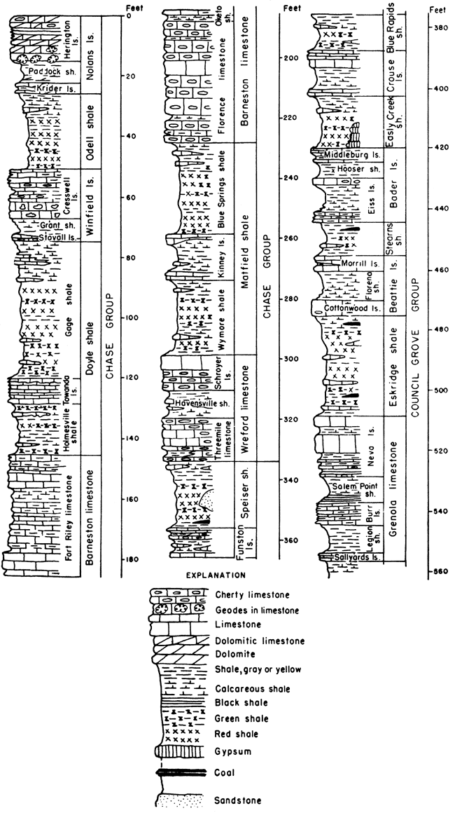
Upper Wolfcampian (Chase) rocks range in thickness from 200 feet in Wallace County to 460 feet in Meade County. Limestones (except Wreford) grade westward into dolomite or dolomitic limestone. Cherty zones (Winfield, Florence, Wreford) are very persistent in the subsurface. Middle Wolfcampian (Council Grove) strata consists mainly of thin limestones separated by shales which are less red and variegated than in the outcrops. Most easily recognized in the subsurface is the Cottonwood-to-Neva sequence. In central and western Kansas, the Neva is generally oolitic. The Foraker limestone contains abundant fusulines, but on account of its shaly character it is not clearly defined in sample or electric logs. Thickness of Council Grove rocks ranges from 300 feet on the Central Kansas uplift and in Wallace County to 500 feet in parts of the Hugoton embayment.
Lower Wolfcampian (Admire) beds lack identifying characteristics in the subsurface. Thin limestones are recognized in samples and electric logs, but their correlation with the outcrops is uncertain. Basal Admire beds (Towle shale, Indian Cave sandstone) can rarely be determined in the subsurface because of their similarity to upper Pennsylvanian rocks. Consequently, the contact of Permian and Pennsylvanian rocks is obscure.
Guadalupian Series
This division of the Permian System, which is defined from fossiliferous marine rocks in western Texas and in southeastern New Mexico, crops out in southern Kansas. In this region, it comprises unfossiliferous deposits that seem to have been laid partly on land by sluggish streams and action of winds and partly in shallow basins occupied by strongly saline waters. Bedding is mostly irregular. Reddish color, which signifies abundance of ferric oxide, prevails. Thickness of outcropping rocks belonging to this series in Kansas is about 290 feet. The subsurface thickness averages about 460 feet in southwestern Kansas.
Figure 15--Guadalupian and Leonardian rocks in Kansas.
Quartermaster Group
Permian beds above the Day Creek dolomite have been classified as belonging in the Quartermaster Group. They seem to be equivalent to the lower part of the Quartermaster formation of western Oklahoma and the panhandle region of Texas. The maximum outcrop thickness of these rocks in Kansas is about 45 feet.
Taloga formation--Redbeds of silty shale, siltstone, and very fine feldspathic sandstone, called "Big Basin" in some reports, belong to the Taloga formation. The lower 25 feet is chiefly silty shale. Outcrops are in western Clark and eastern Meade Counties. The strata are seemingly equivalent, all or in part, to the Quartermaster formation in Oklahoma. Thickness, maximum about 45 feet.
Beds below the Taloga formation and above the Dog Creek shale are not assigned to a group.
Day Creek dolomite--Fine-grained dense dolomite cropping out in western Clark County. It is seemingly absent between the northern part of T. 33 S., R. 24 W. and a point in Oklahoma near the center of T. 25 N., R. 25 W. (Indian meridian). Thickness in Kansas is about 2 feet.
Whitehorse sandstone--Redbeds of feldspathic sandstone, siltstone, and shale and a minor amount of dolomite. Cross bedding is common and the formation is characterized by "sand balls," which are water-worn small "sand crystals" consisting of sand pseudomorphs after calcite, and by crystals of barite, anhydrite, calcite, and gypsum. The outcrops are in southeastern Meade, Clark, and southwestern Kiowa Counties. Thickness is about 270 feet.
Upper shale member--Redbeds of silty shale, siltstone and a minor amount of very fine sandstone, with a zone of dolomitic beds in the basal part and a zone of gray-green sandy shale in the upper part, mostly brick-red or maroon. Thickness is about 38 feet.
Even-bedded Member--Sandstone, very fine, and shaly siltstone, mostly even-bedded but locally cross-bedded in the upper part; containing "sand balls" and "sand crystals"; maroon. Thickness is about 100 feet.
Relay Creek (?) dolomite and sandstone member--Two beds of dolomite separated by red and white fine sandstone. The dolomite beds range in thickness from a few inches to about 1 foot. Locally the dolomite beds are altered to anhydrite or gypsum. Individual layers in the sandstone are identified with difficulty; locally the rock is cross-bedded. Thickness is about 22 feet.
Marlow sandstone member--Redbeds of sandstone, fine-grained, locally shaly or silty, cross-bedded. "Sand balls" locally prominent. Thickness about 110 feet.
Leonardian Series
This major division of the Permian, named from strata in the Glass Mountains region of western Texas, is judged to be represented in Kansas by about 1,900 feet of rocks that are chiefly unfossiliferous clastics (sandstone, shale) and evaporites (anhydrite, gypsum, salt). Red silty shale, siltstone, and sandstone predominate in the upper part. Gray silty shale is the most common rock type in the lower part, although red and other bright colors are present.
Nippewalla Group
The upper part of strata assigned to the Leonardian Series is most widely exposed in south-central Kansas west of Arkansas River. This group consists mostly of redbeds that form a plain. In Barber County and adjacent area the topography of the Nippewalla outcrop area locally has considerable relief and is "badland" in type. Gypsum beds make prominent escarpments. The total thickness of the group is approximately 930 feet.
Dog Creek shale--Maroon silty shale, siltstone, very fine feldspathic sandstone, thin layers of dolomite, dolomitic sandstone, and gypsum. The top generally is marked by about 3 feet of maroon shale, but locally a gypsum bed about 1 foot thick and having red stripes occurs at the top. The most persistent part is a bed of white and red very fine sandstone, about 6 feet thick, that locally is capped by dolomitic sandstone, which occurs next below the upper maroon shale portion. The outcrops are in southern Kiowa, eastern Comanche, and western Barber counties. In Kiowa County the formation is overlapped by Cretaceous sandstone (Cheyenne). Reported thickness ranges from 14 to 53 feet.
Blaine formation--Gypsum beds separated by dolomite and red shale. The formation is divided into four members. Outcrops are in Clark, Comanche, Barber, and Pratt counties. Thickness is about 50 feet.
Haskew gypsum member--One foot or less of gypsum underlain by about 5 feet of red shale. The gypsum bed has been removed by solution at many places. The thickness of the gypsum and underlying shale beds is about 6 feet.
Shimer gypsum member--A thick bed of gypsum overlying a bed of dolomite that ranges in thickness from about 6 inches to 1 1/2 feet. Excessive solution and erosion of the gypsum bed have greatly reduced its thickness in many places. Measured sections believed to show the original thickness range from 14 to 24 feet.
Nescatunga gypsum member--A bed of gypsum with overlying and underlying red shale. The gypsum bed varies in thickness within short distances and is known to range from about 2 to 8 feet. Locally as much as 8 feet of red shale separates the gypsum from the next higher and lower gypsum beds.
Medicine Lodge gypsum member--The thickest bed of gypsum in Kansas. Ordinarily there is a bed of oolitic dolomite at the base which ranges from 6 inches to 1 foot in thickness. Exposures are in Barber, Clark, and Comanche counties. This gypsum bed forms a conspicuous rim rock at the top of steep slopes of the Flowerpot shale. The maximum thickness is 30 feet or more; average 20 feet.
Flowerpot shale--Shale, silty, red, soft, gypsiferous. A thin lenticular bed of dolomite has been observed in the middle part, and the formation is cut by intersecting veins of satin spar gypsum. Thin fine sandstones occur near top. Outcrops are in Barber, southeastern Kiowa, and Comanche counties. Commonly stands in steep slopes, eroded into innumerable gullies, and strewn with clear, white pink, and red satin spar and clear crystals of selenite. Measured thicknesses range from 170 to 190 feet.
Cedar Hills sandstone--Feldspathic sandstone, siltstone, and silty shale, chiefly red, containing beds of white sandstone in the upper and lower parts: the upper one contains "snow balls" of white gypsum. Shaly siltstone separates the more resistant and more massive coarse siltstone and very fine sandstones. The upper part below the "snow ball"-bearing sandstone commonly is eroded into a badland plateau. The more massive sandstones are generally weathered into rounded hills and the shaly portions are weathered into canyon-dissected slopes. Outcrops are in Barber and Harper counties. Thickness is about 180 feet.
Salt Plain formation--Chiefly red, flaky, silty shale and some siltstone. There are two prominent coarse siltstone beds, the upper, about 25 feet thick, occurring about 42 feet below the top of the formation and the lower Crisfield, about 29 feet thick, occurring about 115 feet below the top of the formation. The coarse siltstones are partly cross-bedded. Outcrops are in southeastern Barber, Harper, and southern Kingman counties where the formation has weathered into a nearly featureless plain. In Kingman County the formation is overlapped by Cenozoic deposits. The thickness is reported to be 265 feet.
Harper sandstone--Chiefly red siltstone and very fine sandstone divided into two members. The outcrops are in Harper, Kingman, Reno, and Rice counties. Northward the formation is overlapped by Cenozoic rocks. Thickness is about 220 feet.
Kingman sandstone member--Red siltstone and sandstone and a few beds of red shale and white sandstone. A prominent bed of white sandstone, 3 feet thick, occurs at the base. Thickness is about 80 feet.
Chikaskia member--Siltstone, sandstone, and shale, mostly red but some gray; fissile, fine-grained, ripple-marked, and locally cross-bedded sandstone in lower part. Some white sandstone and dolomite lenses and concretions occur in the upper part. Along the outcrop in Kansas the formation thins northward; the thickness ranges from about 100 to 160 feet.
Sumner Group
This division comprises about 1,000 feet of strata at the outcrop, chiefly silty shale. Thick beds of salt occur in the subsurface. Gray shale predominates but there are also beds of red and green shale and deposits of dolomite, limestone, gypsum, and anhydrite.
Stone Corral dolomite--Dolomite, anhydrite, and gypsum. The anhydrite and gypsum portions are lost in exposed sections and the remaining dolomite ledge is cellular or contains numerous calcite-filled or gypsum filled vugs. The color is chiefly gray but locally there are red and pink streaks. At some exposures the formation is chiefly red shale, bounded above and below by thin dolomite beds. Ripple marks on dolomite slabs are more or less characteristic. The outcrop belt is interrupted in eastern Rice, western McPherson, and other counties to the south by eastward overlap of Cenozoic deposits. This is one of the most readily recognized "key beds" in the Kansas redbed section. It is reported to produce well-marked reflections in seismograph surveys. Maximum measured thickness at the outcrop is about 6 feet.
Ninnescah shale--Predominantly silty shale, mostly red, but containing some gray shale, impure limestone, and calcareous siltstone. The Runnymede sandstone, 7 to 8 feet thick, very fine sandstone and siltstone, forms the upper part of the formation. Weathered surfaces show bright green copper carbonate. Seven other distinctive beds of calcareous siltstone and calcareous shale can be traced for long distances. Cyzicus ("Estheria") shells are rather common. Some of the beds show ripple marks. Rosette-shaped calcareous concretions occur in the middle part. Weathering and erosion in this part have produced the "Red Jaw" country in Reno County. The formation thins northward. In the subsurface near the Nebraska line it is about 50 feet thick. The maximum outcrop thickness is about 450 feet; average thickness at outcrop, about 300 feet.
Wellington formation--Chiefly silty shale, with a few hundred feet of salt in the middle part in the subsurface. Outcrops contain several more or less lenticular beds of gypsum and fine-grained limestone. The Milan limestone member, consisting of 1 foot of greenish-gray shaly limestone that on the outcrop is characterized by bright-green copper carbonate, occurs at the top and thus marks the top of the Wellington formation in a comparatively large area. Elsewhere change in color from gray to red may be regarded as the upper boundary, which may be at different horizons in different places. The upper 300 feet of the Wellington is largely gray shale with thin interbedded deposits of calcareous material. The Hutchinson salt member occurs in the middle part but is not exposed. Individual beds of salt attaining thicknesses of more than 17 feet are mined at Hutchinson, Lyons, and Kanopolis. The fossil insect-bearing Carlton limestone member occurs a short distance below the Hutchinson salt. Bright-red and green shale is conspicuous in the lower part, which contains more or less discontinuous beds of impure limestone and gypsum. A bed of impure dolomitic limestone, not definitely known to be of widespread occurrence, has been named the Hollenberg limestone. In general, outcrops of the Wellington formation are poor and discontinuous. Total thickness of the formation is about 700 feet.
Wolfcampian Series
This division, formerly called the Big Blue Series, contains the older Permian rocks of Kansas. Shales and limestones predominate, subdivisions being remarkably persistent. The thicker shales are bright colored. The outcrop thickness in Kansas is about 785 feet.
Figure 16--Upper Wolfcampian rocks in Kansas.
Chase Group
The topmost group of Wolfcampian beds is made up of about 335 feet of prominent escarpment-making limestones and shales. The shale units are characterized by shades of reds and greens. Chert or flint-bearing limestones are important in this division, which largely comprises the rocks in which the Flint Hills are developed.
Nolans limestone--This formation consists of upper and lower limestone members separated by shale in northern and central Kansas. In southern Kansas member boundaries are not clearly defined. Thickness ranges from about 22 to 35 feet.
Herington limestone member--Limestone and dolomite, yellowish-tan, soft and dense, more dolomitic in southern and central Kansas than in the northern part of the State. Outcrops are characterized by siliceous and calcareous geodes and concretions and cauliflower-like masses of drusy flint weathered from the matrix. Fossil mollusks are locally abundant. Thickness ranges from about 7 to 10 feet in the northern part and is about 30 feet in the southern part of Kansas.
Paddock shale member--Shale, gray; in northern Kansas contains stringers and vein fillings of calcite; in southern Kansas buff, contains dolomite in the lower part. Fossil pelecypods are locally abundant in northern and central outcrops. Thickness ranges from about 7 to 13 feet.
Krider limestone member--Commonly two beds of limestone separated by a bed of shale, each about 1 foot thick. In southern Kansas the separating shale is somewhat thicker. The color commonly is yellowish-brown. Characteristic thickness is about 4 feet.
Odell shale--Shale, chiefly red and green with some gray and yellow. Thicknesses range from about 20 to 40 feet.
Winfield limestone--A thick upper limestone locally cherty underlain by about 10 feet of fossiliferous gray shale, which is underlain in turn by a thin bed of limestone locally cherty. Individual members are not definitely identified in southern Kansas. The combined thickness is about 25 feet.
Cresswell limestone member--This member consists of limestone and locally shale in the upper and middle parts and of massive fossiliferous limestone in the lower part. The upper part, which has been called "Luta limestone," is thinner bedded and more shaly. The shaly middle part commonly contains calcareous concretions, geodes, and locally chert. Echinoid spines and other fossils are plentiful in the lower massive limestone. Throughout a considerable distance the lower massive ledge is almost constantly 3 feet thick. Total thickness of the member is commonly about 17 feet.
Grant shale member--Shale, gray, calcareous and fossiliferous. A distinct unit except in southern Kansas, where it probably has been included in the lower part of the Cresswell limestone. Thickness in northern part is about 10 to 12 feet; in central about 6 feet.
Stovall limestone member--Limestone, gray, dense, with an abundance of steel-gray flint where thin in northern Kansas. It becomes thicker and noncherty in central and southern parts. Fossils are rare. The thickness is commonly about 1 foot.
Doyle shale--Two shale members and a separating limestone member. The thickness is about 70 feet.
Gage shale member--Mostly clayey shale,, but calcareous fossiliferous shale and a minor amount of limestone occur in the upper part. The lower and middle parts are chiefly varicolored noncalcareous shale consisting of red, green, purple, and chocolate-colored zones interbedded with gray and yellow layers. The characteristic thickness is approximately 45 feet.
Towanda limestone member--Limestone, light bluish-gray to yellow, slabby and platy in middle and lower parts, brecciated in upper. Fossils are generally rare. About 15 feet has been measured in Geary County but the common thickness ranges from about 5 to 10 feet.
Holmesville shale member--Shale, unfossiliferous, upper part characteristically green, with gray, yellow, and red; contains impure limestone and "box work." The thickness ranges from about 7 to 30 feet.
Barneston limestone--This formation comprises two limestone members separated by a thin shale member. The upper limestone makes an extensive dip slope and crops out as a steep escarpment that extends from north to south across Kansas. The western part of the Flint Hills is capped chiefly by the Barneston limestone. The thickness of the formation ranges from about 80 to 90 feet.
Fort Riley limestone member--Limestone, light-gray and tan, massive and thin-bedded, and a minor amount of gray shale. In the basal part there are thin, more or less shaly beds that are overlain by a massive "rim rock," which is a conspicuous outcrop maker. Thin shaly beds and locally clay shale deposits occur in the middle part. The upper strata are rather massive but less so than the "rim rock." Fossil algae are conspicuous in "rim rock." Thickness ranges from about 30 to 45 feet.
Oketo shale member--Shale, gray, calcareous. Generally absent in southern Kansas and locally absent elsewhere. The thickness, according to measured sections, ranges from a featheredge to possibly 8 feet, but where present this shale parting between flinty limestone below and nonflinty limestone above is generally less than 5 feet.
Florence limestone member--Limestone, an abundance of flint, and a minor amount of shale. The limestone is commonly lighter in color than the included nodules and layers of gray flint. Shale partings are rather common locally. Fossils are somewhat sparse. In most places along the outcrop the thickness is between 35 and 45 feet.
Matfield shale--Two units of varicolored shale separated by a limestone member. The thickness ranges from about 50 to 80 feet.
Blue Springs shale member--Shale, chiefly red and gray, and a relatively minor amount of limestone except in southern Kansas where several limestone beds occur in the upper part of the member. Farther north the member is less calcareous and limestone is absent. Fossils occur in thin limestones and in gray shale beds in the southern part of the outcrop area. Thickness about 30 feet.
Kinney limestone member--Limestone and shale; generally an upper and lower gray fossiliferous limestone separated by gray fossiliferous shale. The thickness ranges from about 1 to 24 feet.
Wymore shale member--Shale, chiefly gray and yellow but including red, green, and purple bands. Locally most of the unit is composed of bright-colored clay shale. Limestone beds and fossiliferous shale beds are included in the lower part in the southern part of the State. Thickness is about 25 feet.
Wreford limestone--Two limestones and a shale member. The limestone members are characterized by an abundance of flint in some of the beds. The thickness ranges from about 30 to 40 feet.
Schroyer limestone member--Limestone, light-gray to nearly white, mostly flint-bearing, but commonly containing a nonflinty bed (about 3 feet thick) in the upper part. The thickness ranges from about 8 to 20 feet.
Havensville shale member--Shale, gray and calcareous, and thin limestone beds. This unit cannot be easily identified in parts of southern Kansas where the Wreford limestone comprises a more or less continuous limestone section. Thickness ranges from about 6 to 18 feet.
Threemile limestone member--Limestone, light-gray to nearly white flinty in part, but containing massive and more resistant nonflinty beds in middle and lower parts. Thickness ranges from about 7 to 22 feet or more.
Council Grove Group
This division of the Permian rocks comprises about 310 to 330 feet of limestone and shale. In general, these rocks include less massive and thinner limestone units than occur in the overlying group.
Figure 17--Lower Wolfcampian rocks in Kansas.
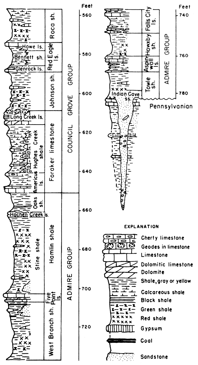
Figure 18--Selected stratigraphic sections of Chase and Council Grove rocks.
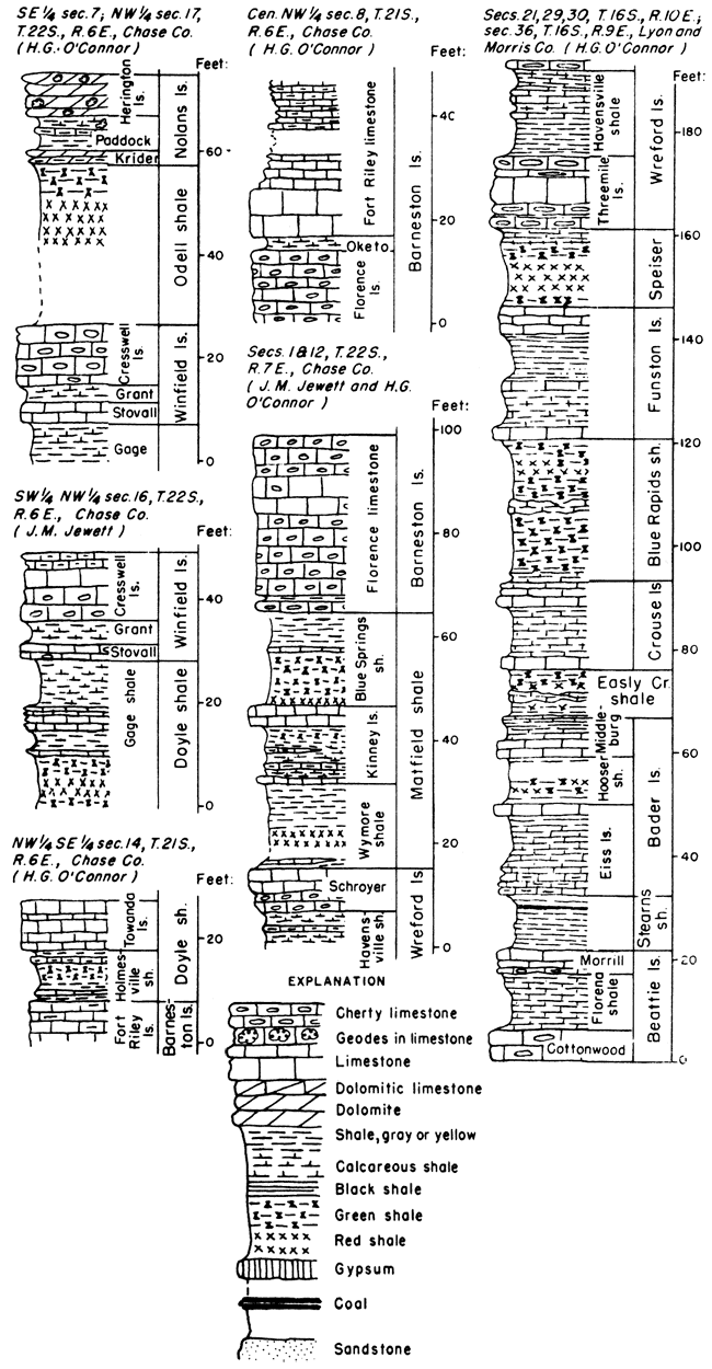
Speiser shale--Shale and limestone. The upper part consists of gray fossiliferous shale underlain by a fairly persistent limestone bed, which is commonly less than 1 foot thick and occurs about 3 feet below the Threemile limestone. The remainder of the formation consists of beds of varicolored shale, red shale being predominant. The thickness of the formation is about 18 feet in northern and central Kansas and about 35 feet in the southern part of the State where a lenticular bed of sandstone occurs in the middle part.
Funston limestone--Light-gray to bluish-gray limestone separated by gray to yellow shale that commonly is abundantly fossiliferous. In southern and central Kansas bluish to nearly black shale occurs in the lower part, and locally the limestone beds contain flint. The thickness of the Funston ranges from about 5 to 26 feet.
Blue Rapids shale--Shale, gray, green and red; containing local limestones and locally a coal bed in Geary County. The thickness ranges from about 15 to 30 feet.
Crouse limestone--Limestone and shale. The formation comprises an upper and lower limestone separated by a few feet of fossiliferous shale. The upper part displays platy structure and weathers tan to brown. The limestone beds locally are flinty. Thickness ranges from about 10 to 18 feet or more.
Easly Creek shale--Shale, red, green, and gray, partly calcareous and containing local limestone beds. The upper part is light-colored and calcareous; the lower part is largely red shale. In Marshall County a commercially worked bed of gypsum, approximately 8 feet thick, occurs in the basal part. Thickness is approximately 15 to 20 feet.
Bader limestone--Two limestones and a shale member. The thickness range is between approximately 15 and 30 feet.
Middleburg limestone member--Limestone and shale. Upper part of upper limestone platy; middle zone olive to dark-gray shale, lower part of which is fossiliferous; lower limestone slabby to massive. Thickness ranges from about 3 to 8 feet.
Hooser shale member--Shale, gray, green, and red. Thickness ranges from about 3 to 8 feet or more.
Eiss limestone member--Limestone and shale. Two beds of limestone separated by shale are remarkably persistent across Kansas. The upper limestone bed, 2 to 3 feet thick, is siliceous and locally contains some flint. The middle part (2 to 11 feet locally) consists of gray fossiliferous shale. The lower limestone, 1 1/2 to 6 feet thick, is shaly, thin-bedded, and fossiliferous. Thickness ranges from about 7 to 18 feet.
Stearns shale--This shale contains a minor amount of impure limestone. The color is mostly gray to olive but red shale occurs in the middle and lower parts; locally contains a thin coal bed in Lyon and Morris counties. Thickness ranges from about 7 feet in southern Kansas to about 20 feet in the northern part of the State.
Beattie limestone--Two limestones and a shale member. Thickness ranges from about 15 to 25 feet.
Morrill limestone member--This unit consists of brown to gray impure cellular limestone that generally contains one or more thin shale partings. In southern Kansas the Morrill thickens, mainly as a result of algal accumulations in the upper part. Thickness ranges from about 2 to about 8 feet.
Florena shale member--A highly fossiliferous gray shale containing thin limestone beds in southern Kansas. The brachiopod Chonetes granulifer is abundant in this shale throughout its line of outcrop. In southern Kansas the variety of fossils is greater than in the north; the fauna contains numerous species of pelecypods and brachiopods and well-preserved specimens of a small trilobite are locally common. The thickness ranges from about 3 to 18 feet.
Cottonwood limestone member--Limestone, massive, light-buff, weathering nearly white, containing abundant slender fusulines in the upper part. In southern Kansas it is thin-bedded and shaly. Throughout parts of its line of outcrop it is marked by a fringe of shrubs along the grass-covered Flint Hills slopes. Except for thinning toward the south, the thickness of the Cottonwood limestone is remarkably constant, amounting to about 6 feet.
Eskridge shale--Shale and a minor amount of limestone and locally thin coal beds. Red and green shale are predominant in most exposures. Ostracodes, mollusks, and algae occur in impure limestones. Coal occurs in the upper part in Brown County. In central Kansas a seemingly persistent limestone ranging up to about 2 feet in thickness, overlain locally by coaly material and underlain more persistently by green shale; occurs a few feet from the base. The thickness ranges from about 20 to 40 feet.
Grenola limestone--Redefined in accordance with usage of the Nebraska Geological Survey to include strata between the base of the Sallyards limestone and the top of the Neva limestone. The thickness ranges from about 38 to 48 feet.
Neva limestone member--Four or five limestones separated by shales. The topmost limestone is algal or molluscan and ranges from a few inches to nearly 6 feet in thickness. It is separated from the main ledge by fossiliferous shale ranging in thickness from about 1 to 6 feet. The main ledge is gray brecciated fossiliferous limestone that weathers pitted and cellular. It ranges in thickness from slightly less than 2 to about 8 feet and locally contains shale breaks. The main ledge is underlain by a persistent shale about 0.5 to 3.5 feet thick, commonly containing fusulines in the upper part and locally black in the lower part. The lower part of the member consists of 2 or 3 limestones separated by thin shales. In southern Kansas these lower limestones are thicker and locally chert-bearing. The upper of these limestones, commonly with fusulines, bears a crust of small brachiopods on its upper surface. The lowermost shale commonly is black. The basal limestone commonly is algal or molluscan. The thickness of these lower beds ranges from about 3 to 10 feet. Thickness of the Neva member ranges from about 16 to 24 feet.
Salem Point shale member--Shale, gray, lower part dark to black, calcareous, without fossils or very sparingly fossiliferous. Thickness ranges from 6 to 10 feet.
Burr limestone member--Limestone, gray, and shale, gray to olive and dark-gray to black in northern Kansas. Ostracodes occur in upper layers and mollusks and other fossils are rather abundant in the lower beds. Thickness ranges from about 8 to 15 feet.
Legion shale member--Shale, mostly gray but locally zones of black; in central Kansas upper part commonly fossiliferous. Thickness ranges from about 4 to 12 feet.
Sallyards limestone member--Limestone, shaly to massive with thin shale breaks. Persistent molluscan fauna, and locally other fossils. Thickness ranges from about 0.5 to 3.5 feet.
Roca shale--Defined to exclude Legion shale and Sallyards limestone. Shale and limestone; gray, red, and green shale and thin impure limestones. Thickness ranges from about 15 to 20 feet.
Red Eagle limestone--Two limestones and a shale member. In southern Kansas the Red Eagle limestone is a single ledge about 20 feet thick, but the two limestone members that are differentiated in central and northern Kansas can be identified also in southern Kansas. The thickness ranges from about 6 to 20 feet.
Howe limestone member--Limestone, variable in lithology and thickness. Foraminiferal in central Kansas. Thickness ranges from less than 1 foot to a maximum of about 15 feet.
Bennett shale member--Shale and locally some impure limestone. The shale is characteristically dark gray to black in lower part and light gray in the upper part. At some exposures, fossil brachiopods are abundant in black shale. The Bennett grades into limestone southward from Elk County. Thickness ranges from about 2.5 to 15 feet.
Glenrock limestone member--Limestone, gray and brown, impure in the northern part of the outcrop area, purer limestone in the central and southern part. Fusulines are characteristic. Thickness in the northern part of the State ranges from about 1 to 2 feet but in central Kansas it is thicker, being as much as 19 feet.
Johnson shale--Shale, gray and green; contains thin beds of argillaceous limestone. Dark carbonaceous material occurs in the upper part. The lower and middle parts are locally somewhat sandy. The thickness ranges from about 14 to about 25 feet.
Foraker limestone--Two limestones and a shale member. The thickness is about 50 feet.
Long Creek limestone member--Alternating beds of yellow limestone or dolomite and shale, or thin-bedded limestone; celestite and colorless to pink or red quartz, in the upper part characteristic. In southern Kansas light-gray limestone, more or less massive in the upper and lower parts, sparsely fossiliferous. Thickness ranges from about 4.5 to possibly 17 feet.
Hughes Creek shale member--In northern and central Kansas this part of the Foraker comprises light-gray to nearly black shale and thin limestone beds containing a profusion of fusulines and abundant brachiopods. In southern Kansas the member is a nearly continuous limestone section, massive in the lower part and containing much light-blue flint. Fusulines are plentiful in the flint and limestone. Thickness ranges from about 20 to 40 feet.
Americus limestone member--Commonly two limestone beds separated by shale, the upper bed containing flint nodules in southern Kansas. The limestone commonly is bluish-gray and the shale is gray to nearly black. Fusulines and brachiopods are plentiful. The upper limestone ranges from about 1 to 5 feet in thickness. It is shaly in part. Northward from Wabaunsee County it is represented by shaly limestone or calcareous shale, and strata between the Long Creek limestone and the basal limestone bed of the Americus are included in the Hughes Creek shale. The shale between the two main limestone units, where identifiable, ranges from about 3 to 13 feet in thickness. The lower limestone, commonly with a shale break, ranges from about 2 to 4 feet in thickness. Rhombic blocks of limestone mark the outcrop of the lower bed across the State.
Admire Group
This division chiefly consists of clastic deposits but contains thin limestones and some coal. Shale predominates. The thickness, except in places where the Indian Cave sandstone is present, is about 130 feet. The maximum thickness of the Indian Cave sandstone is reported to be 250 feet in Pottawatomie County.
Figure 19--Selected stratigraphic sections of Council Grove, Admire, and Wabaunsee rocks.
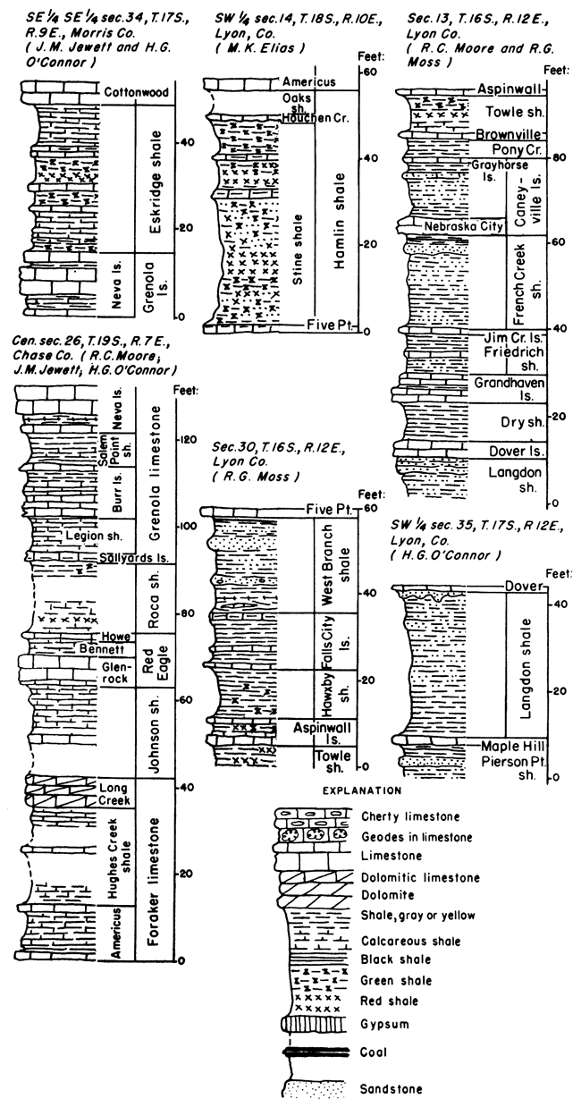
Hamlin shale--Two shales and a limestone member. Thickness about 50 feet.
Oaks shale member--Shale, mostly gray, locally nearly black in part. Crystals of pink celestite occur as vein fillings in Brown County. Thickness ranges from a featheredge in Wabaunsee County to a maximum of about 20 feet in northern Kansas, and from about 2 to 12 feet in central and southern Kansas.
Houchen Creek limestone member--Limestone, upper gray, commonly consisting largely of lobate algal deposits, massive; lower part porous, silty, impure, yellow-brown. Thickness ranges from about 1 to 4 feet.
Stine shale member--Shale, red, green, and gray, small amount of sandstone, and thin limestone beds. Thickness ranges from 30 feet or less to about 50 feet.
Five Point limestone--One or more limestones, massive to slabby, fossiliferous; locally upper part a thin coquina. Thickness is about 1 to 8 feet.
West Branch shale--Shale, gray, green, and red, upper part sandy in central and southern Kansas; contains up to 5 or more feet of sandstone in upper part locally. One or more coal beds occur rather persistently in the upper and middle parts. Limestone lenses occur in the West Branch shale in northern Kansas; lower boundary not definitely determined in southern part of the State. Thickness ranges from about 20 feet to about 40 'Feet in the northern part of the State.
Falls City limestone--In central and northern Kansas upper and lower limestone beds separated by gray shale. Upper boundary undetermined in parts of southern Kansas. Limestone beds are argillaceous and commonly are molluscan with some bryozoans and brachiopods. Cone-in-cone zones are characteristic of upper beds in central Kansas. Lower beds, locally, are thin impure limestones or zones of limestone nodules. The thickness where determined ranges from about 9 to 15 feet.
Hawxby shale--Shale, gray to yellow, and especially in lower part, green and red. Upper part calcareous and locally sandy. Thickness ranges from about 6 to 15 feet.
Aspinwall limestone--One limestone bed or several separated by calcareous shale. Thickens southward with calcareous shale becoming dominant in lower and middle parts. Commonly sparsely fossiliferous with mollusks and productid brachiopods predominant. Thickness ranges from about 1 to 15 feet.
Towle shale--Clayey and silty shale, siltstone, sandstone, and locally thin limestone; gray, red, and green clay, locally sandy. The Indian Cave sandstone occurs in the lower part filling channels cut into Pennsylvanian rocks. Thickness of the Towle shale where the Indian Cave is absent ranges from about 2 to 17 feet.
Indian Cave sandstone member--Sandstone, siltstone, and locally conglomerate in part; occurs as local channel fillings that grade upward into the basal part of the unnamed upper member of the Towle shale. Reported maximum thickness, about 250 feet.
This seemingly important, although obscure, unconformity is marked mainly by large channel sand fillings that occur at intervals from Nebraska into Oklahoma. Massive sandstone, well exposed in the Indian Cave type locality in Nebraska, in eastern Wabaunsee County, in southeastern Cowley County, and elsewhere has been identified as Indian Cave. Erosion channels below the Indian Cave sandstone bring deposits classified as lowermost Wolfcampian into contact with rocks ranging downward from the Brownville limestone, or possibly slightly younger beds, to the Auburn shale. This evidence of widespread erosion, accompanied by rather noteworthy change in the lithologic characters of limestones, and paleontologic change, which is accentuated by the disappearance of old species and the appearance of some new genera and species, warrant the placement of the Wolfcampian-Virgilian boundary at this position.
Prev Page--Igneous and Metamorphic || Next Page--Paleozoic--Pennsylvanian System
Kansas Geological Survey, Geology
Placed on web Oct. 28, 2008; originally published Jan. 1951.
Comments to webadmin@kgs.ku.edu
The URL for this page is http://www.kgs.ku.edu/Publications/Bulletins/89/06_pale.html