![]()
Prev Page--Cenozoic || Next Page--Igneous and Metamorphic
Mesozoic Rocks
Deposits of Mesozoic age, comprising part of the geologic section of Kansas, belong mostly to the Cretaceous System. These rocks cover many thousand square miles in the western part of the State. Older Mesozoic rocks, probably representing both the Jurassic and Triassic Systems, are identified in well borings but are absent or, in the case of Triassic, somewhat doubtfully recognized very locally in surface exposures.
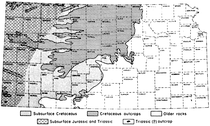
Distribution and structure--The outcrops of Mesozoic strata in Kansas are confined to the western two-thirds of the State. They extend much farther eastward along the northern border (Marshall County) than in the south (Barber County); in central Kansas exposures are found eastward as far as Dickinson and Marion counties. Mesozoic rocks underlie thousands of square miles in western Kansas where Cenozoic formations cover the surface. In general, the Mesozoic strata are gently inclined toward the northwestern corner of Kansas, dipping westward, northwestward, or northward.
Cretaceous System
Character and surface distribution--Rocks of Cretaceous age crop out at the surface or underlie much of central and western Kansas. These rocks are mostly marine, but deposits of supposed continental origin are found in the Cheyenne sandstone and Dakota formation. Clayey and calcareous shale is the dominant constituent but fine-grained platy and chalky limestone comprises most of the Greenhorn and Niobrara, and sandstones occur in the Cheyenne, Kiowa, Dakota, Graneros, and Carlile. In general, these rocks dip very gently westward, but locally dips may occur in any direction. Small outcrops of dark-colored igneous rocks that penetrate Permian strata in Riley County are possibly Cretaceous in age. The thickness of the Cretaceous System in Kansas is about 2,750 feet.
Subsurface features--In the subsurface the rocks assigned to the Gulfian Series display a remarkable degree of uniformity throughout the State; although some progressive changes in thickness occur, their essential characteristics remain the same. Rocks assigned to the Comanchean Series, however, display progressive overlap on the pre-Cretaceous rocks. The lowermost Cretaceous unit (Cheyenne sandstone) thickens from a featheredge to more than 300 feet in Russell and Ellis counties,
Figure 10--Distribution of Triassic, Jurassic, and Cretaceous deposits.
Gulfian Series
The upper part of the Cretaceous System is defined as the Gulfian Series. At the beginning of Gulfian time, continental and littoral deposits accumulated in Kansas, but these conditions rapidly gave way to marine conditions and the shales and limestones constituting the Colorado and Montana groups were deposited. Thickness about 2,500 feet.
Montana Group
Dark-colored marine shales that crop out and underlie the surface of northwestern Kansas. Thickness 1,000 to 1,400 feet; average 1,235 feet.
Pierre shale--Shale, thin-bedded, black to dark-gray, a few beds lighter in color, weathers to coffee-brown and gray; marine; contains concretions, selenite crystals, thin beds of bentonite, and locally chalky beds. Occurs in northwestern Kansas. Thickness ranges from 1,000 to 1,400 feet.
Beecher Island shale member--Shale, gray. Irregular concretionary limestone near top, limonite concretions throughout, thin beds of bentonite and limestone concretions in lower part. Thickness, 100 feet.
Unnamed shale member--Shale, black to gray. Thickness ranges from 500 to 600 feet.
Salt Grass shale member--Shale, clayey, gray; contains numerous thin bentonite beds, limestone concretions, and concretionary limonite zones distributed throughout. Thickness, 60 feet.
Lake Creek shale member--Shale, thin-bedded, flaky, dark-gray and black; limestone concretions, zones of concretionary limonite, and locally gypsum are present. Thickness, 200 feet.
Weskan shale member--Shale, clayey, gray. Bentonite beds more abundant in lower part, large limestone concretions and some limonite. Thickness, 170 feet.
Sharon Springs shale member--Shale, flaky, black, somewhat bituminous, large septarian and ordinary limestone concretions abundant in upper part; a few beds of light-gray shale, locally thin chalk beds in lower part. Thickness, 155 feet.
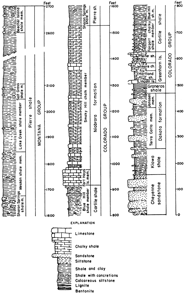
Figure 11--Cretaceous rocks in Kansas.
Colorado Group
Shales, calcareous and noncalcareous, that crop out and underlie the surface of north-central, northwestern, and west-central Kansas. Limestone beds occur interbedded with the calcareous shales. These rocks are all of marine origin. Thickness, about 1,050 feet.
Niobrara formation--Calcareous shale and chalk, soft, interbedded, light-gray. Crops out in a belt trending generally northeast-southwest and extending from north-central to western Kansas. Thickness, 500 to 750 feet in Logan and Wallace counties; average, 600 feet.
Smoky Hill chalk member--Shale, chalky, interbedded, gray, weathers white, yellow, and orange; contains limonitic concretions, and locally massive chalk beds. Forms badland topography. Thickness, 450 feet to 700 feet in Logan County; average, 550 feet.
Fort Hays limestone member--Chalk or chalky limestone, gray to cream-colored, massively bedded; thin beds of light to dark-gray chalky clay shale separate the massive chalky limestone beds. Extensively used for building stone. Thickness ranges from 45 feet in Smith County to 65 feet near the Colorado line.
Carlile shale--Shale, chalky in lower part and containing thin chalk beds and bentonites near the base, black fissile shale and large septarian concretions in upper part, locally fine-grained sandstone at top; marine. Occurs in northwestern and western Kansas. Thickness, about 300 feet.
Blue Hill shale member--Shale, clayey, gray-black to dark-gray, noncalcareous; abundant ordinary and septarian concretions and selenite crystals. Contains Codell sandstone zone in upper part; sandstone fine-grained and silty, maximum thickness 25 feet in Hamilton County; locally represented by silty shale and thin sand laminae in the shale. Thickness, 75 feet in Hamilton County to 200 feet in Russell County.
Fairport chalky shale member--Shale, calcareous, and thin chalk beds, blue-gray to gray, weathers to light orange-tan; thin bentonite beds in base; chalky limestones more abundant near base. Thickness, 85 feet in Russell County to 147 feet in Hamilton County; average, 125 feet.
Greenhorn limestone--Chalky limestone and calcareous shale, interbedded, thin-bedded, light-gray to dark-gray, weathers yellow-gray to light-gray; marine. Occurs in northwestern and western Kansas. Thickness, 65 feet in Jewell County, 95 feet in Ellis County, to 132 feet in Hamilton County; average, 100 feet.
Pfeifer shale member--Chalky shale and chalky limestone in alternating layers. Fencepost limestone bed at top, blue-gray, weathers to light-tan. In Hamilton County the Pfeifer shale member and the underlying Jetmore chalk member are thicker than farther east. They cannot be distinguished and have been together designated the Bridge Creek limestone member, having a total thickness of 74 feet. Thickness of Pfeifer shale is typically 19 to 21 feet in Ellis and Russell counties; average, 20 feet,
Jetmore chalk member--Chalky shale and chalky limestone, interbedded, "Shell-rock limestone" bed at top, gray, weathers to light-gray. Thickness ranges from 20 feet (Russell and Ellis counties) to 25 feet; average, 22 feet.
Hartland shale member--Chalky shale, a few thin beds of chalky limestone and bentonite, gray. Thickness 23 feet in Kearny County to 35 feet in Ellis County; average, 30 feet.
Lincoln limestone member--Chalky shale and chalky limestone, interbedded, light-gray; beds of dark-gray petroliferous hard crystalline limestone at base and top; shale contains thin beds of bentonitic clay. Member weathers to yellow-gray or yellow-tan. Thickness, 20 feet (Ellis County) to 35 feet; average, 28 feet.
Graneros shale--Shale and clay shale, fissile, noncalcareous, blue-black, weathers to dark-gray and coffee-brown; largely or entirely marine but mostly unfossiliferous; locally contains sandstone beds and beds of "clay ironstone"; selenite crystals abundant. Rarely thin limestones in upper part. Thickens southward across western Kansas. Thickness ranges from 30 to 35 feet in Russell County to 65 feet near the Colorado line; average, 45 feet.
The rocks which comprise the Dakota formation, Kiowa shale, and Cheyenne sandstone formerly were classed as the Dakota group. The use of this grouping has been discontinued.
Dakota formation--Clay, shale, siltstone, and sandstone, interbedded and lenticular; contains carbonaceous material, lignite, concretions of hematite and limonite, and locally quartzitic sandstone; white, gray, red, brown, and tan. Occurs in north-central and western Kansas. The Cockrum sandstone of southwestern Kansas is equivalent in age to part of the Dakota formation. Contains plant fossils and land vertebrates. Thickness, 100 to 300 feet.
Janssen clay member--Clay, silt, and fissile shale, with lenticular sandstone, lignite, and lignitic clay common; gray to dark-gray, contains concretionary hematite and limonite and beds of "ironstone." Central and north-central Kansas. Thickness ranges from 30 to 80 feet.
Terra Cotta clay member--Clay, shale, sandstone, and quartzitic sandstone, interbedded; red, gray, brown, and tan. Central and north-central Kansas. Sandstones are lenticular and weather brown, coarse-grained to fine-grained, abundant hematite and limonite concretions throughout. Quartzitic sandstone near top. Thickness 70 to 220 feet.
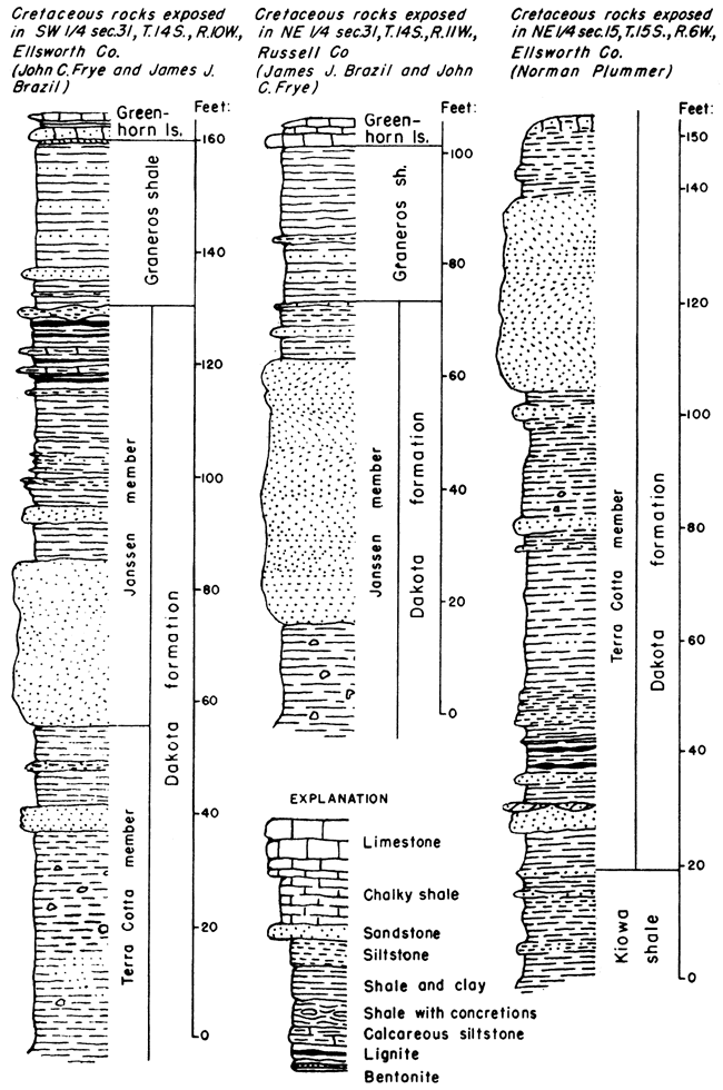
Figure 12--Selected stratigraphic sections of the Dakota and Graneros formations.
Comanchean Series
The lower part of the Cretaceous System is defined as the Comanchean Series. At the beginning of Comanchean time the Kansas area was being eroded and only upper Comanchean deposits occur in the state. The oldest Comanchean deposits in Kansas represent continental and littoral deposits laid down as the sea advanced northward. These nonmarine conditions rapidly gave way to marine conditions, and marine shales overlie the nonmarine and littoral deposits. These rocks crop out in a belt extending diagonally north to south across central Kansas, and at a few places in southwestern Kansas. Thickness ranges from a featheredge to 400 feet; average, about 250 feet.
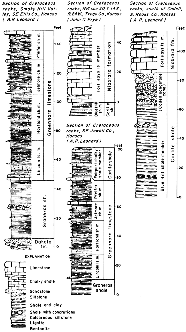
Figure 13--Selected stratigraphic sections of the Greenhorn, Carlile, and Niobrara formations.
Kiowa shale--Shale, fissile, light-gray, dark-gray, and black; contains thin limestone beds throughout, with the Champion shell bed at the base in the type area: Locally, lenticular sandstones occur at any position within the shale; beds of cone-in-cone; quartzitic sandstone; selenite crystals common. Abundant marine molluscan fauna in the thin limestones, shale, and sandstone. Thickens across central and western Kansas toward the south and southwest. Typical thickness, 60 to 150 feet.
Cheyenne sandstone--Sandstone, white, buff, gray, tan, red, yellow, and purple, with white, light-gray, and buff dominant; and shale, light-gray to dark-gray. Sandstone, very fine-grained to coarse-grained, dominantly quartz, cross-bedded: shale, sandy and silty, cross-bedded, dark-gray, contains plant remains. Cobble zone at base, locally conglomeratic; locally a zone of re-deposited red Permian sand at base. Thickens westward in the subsurface. Maximum thickness exposed, more than 75 feet; maximum thickness in the subsurface, 300 feet.
A major unconformity marks the base of the Cretaceous rocks. The Cretaceous rocks overlap northward on the pre-Cretaceous erosion surface, successively younger beds lying above the contact northward across the State, ranging from the Cheyenne sandstone in Comanche and Kiowa counties to the Dakota formation in Washington County. Rocks underlying the unconformable contact range in age from the Herington limestone in Washington County to beds believed to be of Jurassic age in northwestern Kansas. A discontinuous zone of pebbles and cobbles occurs above the unconformity along the line of outcrop, the pebbles being included in Cheyenne sandstone, Kiowa shale, or Dakota formation as each constitutes the lowermost Cretaceous unit. The pebbles consist of igneous and metamorphic rocks and chert, with quartzite and chert predominating; they are well rounded and judged on the basis of lithology and contained fossils to have come from the northeast.
Jurassic and Triassic Systems
Deposits judged to be of Jurassic and Triassic age occur in the subsurface throughout the western one-fifth of Kansas and crop out in a small area in southern Morton County. They consist primarily of varicolored shales and red sandstones and attain a maximum thickness of more than 325 feet. In the subsurface they pinch out eastward along an irregular line extending from Stevens County to Norton County and in general thicken toward the west. The Jurassic Morrison formation is judged to comprise most of this interval in northwestern Kansas, whereas Triassic sandstones tentatively assigned to the Dockum group are predominant in southwestern Kansas.
Morrison formation--Shales correlated with the Morrison formation of the Jurassic System have been penetrated by drilling in northwestern Kansas. The shales are predominantly green in color and are characterized by pink jasper-like chert and pink gypsum. Where noted in wells, these shales range in thickness from 100 to 275 feet.
Dockum (?) Group
Continental deposits of early Mesozoic age, identified as Triassic on the basis of vertebrate and plant remains, are widespread in western Texas and New Mexico. Certain outcrops in the panhandle of Oklahoma and southwestern Kansas, which possess similar lithology, are judged to be equivalent to the Triassic rocks farther south. Inasmuch as comparable Triassic rocks in Texas are called Dockum group, this name is tentatively employed in southwestern Kansas. Red siltstone, buff and white sandstone, and a small amount of gypsum are exposed in Morton County. Maximum exposed thickness is about 40 feet but in the subsurface of Morton and Stanton Counties the thickness may be greater.
Prev Page--Cenozoic || Next Page--Igneous and Metamorphic
Kansas Geological Survey, Geology
Placed on web Oct. 28, 2008; originally published Jan. 1951.
Comments to webadmin@kgs.ku.edu
The URL for this page is http://www.kgs.ku.edu/Publications/Bulletins/89/04_meso.html