![]()
Prev Page--Paleozoic Rocks--Permian System || Next Page--Pre-Pennsylvanian
Paleozoic Rocks, continued
Pennsylvanian System
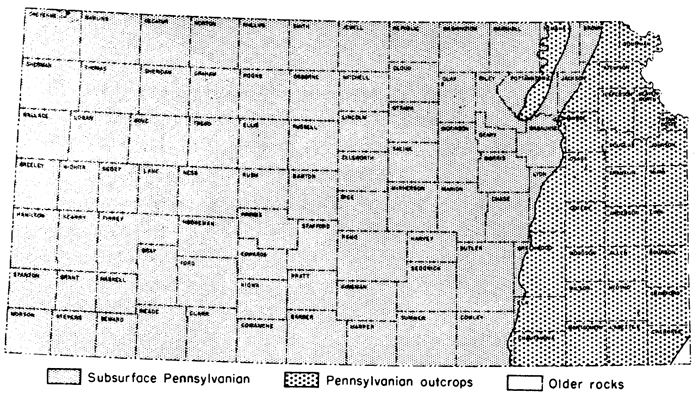
Character and surface distribution--This division of Late Paleozoic rocks is widely represented throughout the world, being distinguished by importance of its coal deposits and by characters of its large assemblage of marine invertebrates and varied land plants. It is one of the most important among outcropping strata of Kansas, both on account of the economic value of its contained materials and the prominent status of its rock succession as a standard of reference in studies of equivalent-aged deposits in other parts of the continent. The Pennsylvanian rocks comprise the upper part of a large division that has long been known as the Carboniferous System. The term Carboniferous is almost universally used by geologists outside of North America and has been employed by the State Geological Survey of Kansas in designating outcrops shown on the large geological map of the State (1937) and described in numerous reports. Pennsylvanian rocks have been classified in these publications as a subsystem. Here, we recognize the validity of considerations that have led a great majority of American geologists to treat the Pennsylvanian as an independent geologic system. The aggregate thickness of exposed formations belonging to this system in Kansas is about 3,100 feet. Outcrops occur throughout the eastern one-fourth of the State.
Subsurface distribution and structure--The well cuttings from Pennsylvanian rocks do not reveal weathering characteristics, paleontologic content (except Foraminifera), or cyclical attributes of the sediments, which aid in distinguishing the formations in the outcrops. Sample logs generally show a monotonous succession of limestones, some of which are cherty and oolitic. Chert is a persistent characteristic of some beds, but chert occurs locally in nearly every limestone. Oo1ites and algal remains are recognizably persistent only locally.
In most subsurface areas, the top and bottom of conspicuously calcareous groups can be determined approximately in sample logs and accurately in electric logs. The extraordinarily close approach to parallelism of the limestones above the Cherokee and their slow convergence toward the west and toward local anticlinal features permits identification in electric logs of formations and members occurring between datum horizons. Toward the south, limestone beds disappear.
Figure 20--Distribution of Pennsylvanian rocks.
All series and group divisions of the Pennsylvanian succession (except Pedee) have been traced westward in the subsurface to the Colorado line, although some units wedge out or become indistinguishable. Northward thinning of shale formations and members, as seen in outcrops, has its counterpart in westward thinning of shales in the subsurface. Some limestones also become thinner and wedge out westward, but they are much more persistent than the shales. In western Kansas, the Pennsylvanian System consists mainly of limestones separated by shale beds, most of which are so thin that they can be recognized only in the electric logs. As along outcrops, most shales in the subsurface thicken southward toward the Oklahoma border, and many limestones wedge out or grade into shale or sandstone in this direction.
The principal datum horizons in the subsurface Pennsylvanian succession are the top and base of the Shawnee group, top of the Lansing group, base of the Kansas City group, and (in many areas) base of the Marmaton group. The Oread is well identified in electric logs by the distinctive pattern of the Heebner and Snyderville shales, separated by thin Leavenworth limestone.
Although thickness of the Pennsylvanian Series and its constituent groups increases southeastward, the regularity is modified by local structural features developed by differential movements during Pennsylvanian time. Before earliest Pennsylvanian sedimentation in eastern Kansas, the beveled surface of Mississippian and older rocks was deformed by revival of the Nemaha anticline, Central Kansas uplift, and various minor structures. Downward movement of this surface east of the Nemaha anticline allowed accumulation of 700 to 1,000 feet of Desmoinesian rocks (Marmaton and Cherokee) in the Forest City basin. A maximum of only 400 feet of Desmoinesian rocks accumulated in the deepest part of the Salina basin. The crest of the Nemaha anticline was only thinly covered by Desmoinesian rocks. At the Burns dome in Butler County, only the Marmaton was deposited on the crest of the rising Nemaha anticline. Near the Nebraska line, the crest was not covered by sediments until early Kansas City time. Varying thicknesses of Desmoinesian rocks cover the crest of the Nemaha at other less elevated points. In general, greater thicknesses of Desmoinesian rocks overlie the crest of the Nemaha anticline toward the south.
Parts of the Central Kansas uplift were not covered by Pennsylvanian sediments until Kansas City time. The differential character of the structural movement in this region is revealed by gradual thinning of all Pennsylvanian groups above the Desmoinesian over crests of both major and minor anticlines. Most of the Pennsylvanian groups thicken in the contemporaneously subsiding Hugoton basin. In southwestern Kansas, the thickness of the Desmoinesian (about 640 feet in Meade County) is exceeded only in the Forest City and Cherokee basins.
Rocks of Atokan and Morrowan age were deposited in the Hugoton basin before Pennsylvanian deposition began in eastern Kansas. In Meade County, the Atokan is about 400 feet thick and the Morrowan about 135 feet thick but in Morton County there is more than 400 feet of Morrowan rocks. Both Atokan and Morrowan in Kansas are confined to the Hugoton basin, where they thin northward.
Virgilian Series
The Virgilian Series comprises the youngest Pennsylvanian rocks of the midcontinent region. They are separated from rocks above and below by unconformities. In Kansas this series is divided into three groups on the basis of general differences in lithology and the nature of cyclic deposits. The thickness is commonly about 1,200 feet.
Wabaunsee Group
The upper-most major division of Virgilian strata includes beds below the unconformity that separates Permian and Pennsylvanian rocks and above the top of the Topeka limestone. Where the Indian Cave sandstone is absent the top of the Pennsylvanian is drawn at the top of the Brownville limestone. Limestones in this group are uniformly thin but persistent. Sandstone is plentiful, but shale is the chief rock. The thickness of the Wabaunsee group is about 500 feet, excepting in places where the overlying unconformity cuts out the upper beds.
Figure 21--Virgilian (upper Wabaunsee) rocks in Kansas. Read Pierson Point shale for Wamego shale.
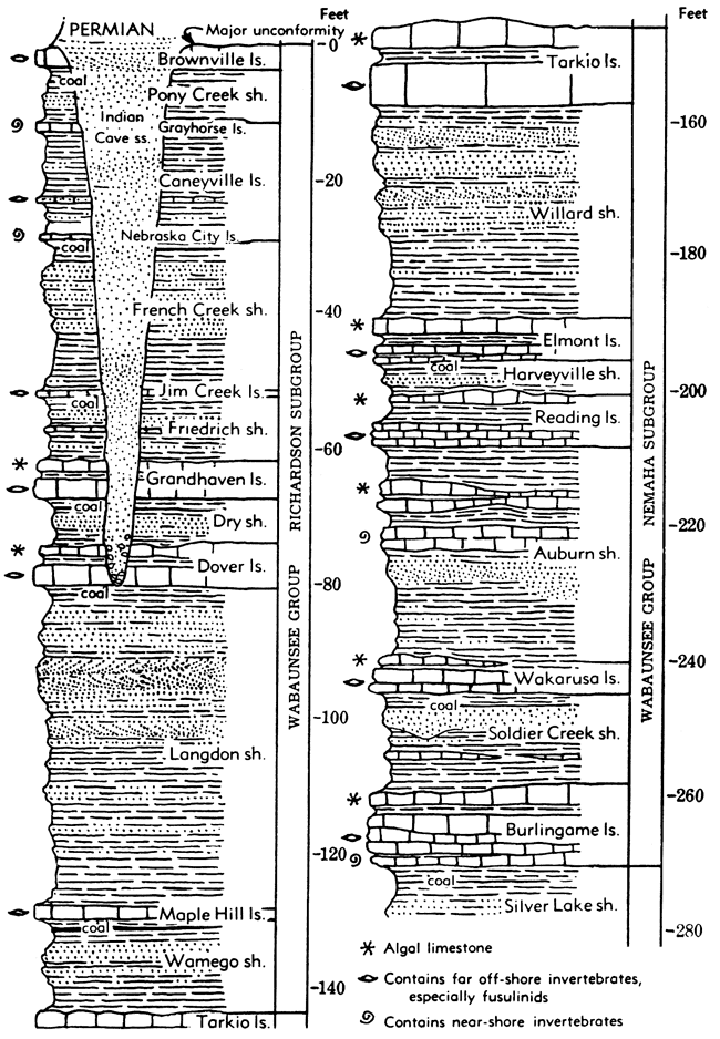
Richardson Subgroup
Strata from the top of the Brownville limestone to the top of the Tarkio limestone are included in the Richardson subgroup. This division can be distinguished in northern Kansas. The thickness commonly is about 140 feet.
Brownville limestone--Bluish-gray limestone that weathers yellowish or brown, occurring in one bed or in two beds separated by a thin layer of shale. Varying texture from impure sandy-appearing rock to fairly pure dense limestone. Characteristic fossils include large fusulines, brachiopods Meekopora and Chonetes granulifer, crinoid fragments, and bryozoans. The thickness ranges from about 2 to 8 feet.
Pony Creek shale--Bluish-gray shale chiefly, some red clay shale or sandy shale locally. Commonly sandstone or siltstone occurs near the middle part, locally this type of deposit fills channels cut downward into beds as low as the Friedrich shale or lower. A thin coal bed occurs in the upper middle part in southern Kansas. Brachiopods and bryozoans more or less common in upper layers. Thickness ranges from about 5 to 50 feet or more.
Caneyville limestone--Three limestones and separating shales in the southern part of the outcrop area; two limestones and a shale elsewhere. Thickness ranges from about 12 to 25 feet.
Grayhorse limestone member--Gray, medium- to coarse-grained limestone, fragmental or coquinoid, ferruginous, broken surfaces showing curved cleavage surfaces of iron- or magnesium-bearing carbonate crystals. Large specimens of Myalina are rather common. Thickness ranges from about 0.5 to 6 feet.
Shale ranging in thickness from about 10 to 23 feet; contains locally in southern Kansas about 1 foot of fusuline-bearing limestone.
Nebraska City limestone member--Gray, impure, soft limestone; contains bryozoans, brachiopods, algae, and sparse mollusks. Thickness ranges from about 1 foot to 5 feet.
French Creek shale--Bluish-gray to yellowish-brown clayey and sandy shale commonly containing light-brown or tan sandstone and one or more coal beds in the upper part. Thickness ranges from about 20 to 45 feet.
Jim Creek limestone--A persistent bluish-gray, fine-grained, hard limestone, containing in many places slender fusulines and, more locally, a large variety of other marine fossils. The thickness ranges from a few inches to about 2 feet.
Friedrich shale--Bluish-gray shale that weathers yellowish and brown. Sandstone is more or less common and in southern Kansas thin coal and limestone beds are included. Locally sandstone-filled channels cut downward 30 feet or more into lower beds. Contains pelecypods, sparse bryozoans, and brachiopods. Thickness ranges from about 5 to 40 feet or more.
Grandhaven limestone--Commonly two limestones separated by a few feet of shale, less commonly a single bed. The upper limestone is light-gray and weathers almost white, oolitic or algal deposits forming a prominent part of the rock. In exposures along Cottonwood River, this member is cross-bedded and carries abundant brachiopods and bryozoans and some mollusks. Large fusulines are present at some outcrops. The formation is traced from Shawnee County southward to Oklahoma and may be recognized north of Kansas River. The thickness ranges from about 2 to 10 feet.
Dry shale--Gray, locally red and green, generally clayey, but locally somewhat sandy shale containing a thin coal bed in southern Kansas. Marine fossils are abundant locally in the upper part. The thickness ranges from about 3 to 20 feet.
Dover limestone--In northern Kansas commonly a single bed of limestone and in central Kansas a single bed of limestone or calcareous sandstone. Southward from Greenwood County a fine-grained blue-gray limestone with a mixed fauna of mollusks and brachiopods occurs below the more persistent and characteristic fusuline- and algal-bearing part. The thickness in northern Kansas ranges from about 1 to 5 feet; in southern counties, where shale comprises most of the formation, the thickness is as much as 24 feet.
Langdon shale--Bluish-gray clayey to sandy shale, containing the persistent thin Nyman coal and locally platy to massive sandstone in the upper part. Marine invertebrates are abundant at places in northern Kansas below the upper sandy facies. Not differentiated from the Pierson Point shale south of Cottonwood River. Thickness ranges from about 5 to 50 feet.
Maple Hill limestone--Gray, medium-hard limestone, weathering reddish-brown; generally bearing crinoid remains, bryozoans, brachiopods, and sparse mollusks. Fusulines are more or less common. The Maple Hill limestone is not definitely recognized south of Emporia but is believed to be represented in southern Kansas by thinner-bedded limestone. Thickness about 1 to 4 feet.
Pierson Point shale--Bluish-gray clay shale and yellowish-brown micaceous sandy shale, locally containing a zone of mixed fauna; nearly black shale locally in the upper part. Between Kansas and Cottonwood Rivers a more or less persistent coal bed occurs in the upper-middle part. A mixed marine fauna. The formation is not differentiated from the Willard shale south of Lyon County. The term "Wamego shale" was introduced a few years ago by the Nebraska Geological Survey to replace Pierson Point, then thought to be unsuited for these beds. Recently, however, the Nebraska Survey has found that the older name is appropriate. The thickness ranges from about 4 to 25 feet.
Nemaha Subgroup
Strata from the top of the Tarkio limestone to the base of the Burlingame limestone comprise the Nemaha subgroup. This division is distinguished in northern Kansas. The thickness commonly is about 160 feet.
Tarkio limestone--This formation, consisting of gray limestone that weathers deep yellowish brown, is one of the most easily recognized units in the Wabaunsee group. It is characterized by the brown color of weathered outcrops and the abundance of large fusulines. Locally algal remains occur in the upper part. The formation is present from a point in northern Lyon County northward across the State, and seemingly occurs at some places in southern Kansas. The thickness ranges from a featheredge to about 10 feet.
Willard shale--Dark bluish-gray and brown shale, and sandstone. Sandstone is prominent in many places in northern Kansas but thin or absent farther south. Inasmuch as the Maple Hill and Tarkio limestones are not recognized in southern Kansas, the shale and sandstone section containing one or more local coal beds extending from the base of the Willard to the top of the Langdon shale is designated as the Willard-Langdon shale; its thickness ranges from about 10 to 55 feet. The thickness of the Willard in northern Kansas ranges from about 30 to 65 feet, the maximum being near Kansas River.
Elmont limestone--Dark-blue massive limestone containing fusulines and brachiopods; weathers bluish-gray and displays closely spaced vertical joints. Locally a coquinoid or conglomeratic limestone occurs above the persistent fusulinid bed and is separated from it by a few inches to several feet of shale. Other exposures show a conglomerate of limestone pebbles associated with one or more brachiopod and molluscan beds below the fusulinid bed. Thickness ranges from about 1 to 15 feet
Harveyville shale--Bluish and greenish-brown clayey shale, locally sandy shale and thin platy sandstone. In places a coal bed occurs above the sandstone and marine invertebrate fossils are found above the coal horizon. The formation is continuous across Kansas, having a thickness range from less than 1 to 25 feet.
Reading limestone--The most persistent part consists of dark-blue, dense, hard limestone showing vertical jointing, and weathering light bluish gray mottled with light brown or yellow. The formation comprises one to four beds of limestone and blue-gray shale beds locally with a coal bed in southern Kansas between the limestone layers. Fusulines are characteristic of the persistent dense blue limestone. Locally an upper algal phase is present as a single distinct limestone above the more persistent part, and a brachiopod- and pelecypod-bearing limestone may be present below the persistent bed. Thickness of the formation is about 1.5 to 15 feet.
Auburn shale--A somewhat complex and variable unit composed chiefly of shale, containing minor amounts of sandstone and limestone, part of which is chalky. Near Kansas River there are lenses of cross-bedded limestone and conglomerate and coquinoid masses of molluscan and algal remains as much as several feet thick. Dark shale containing numerous ostracodes and pelecypods occurs locally. There are two or more local coal beds. The thickness of the formation in Kansas ranges from about 20 to 70 feet.
Wakarusa limestone--Dark bluish hard limestone that becomes brown when weathered. Locally, an algal-molluscan or fine-grained sandy limestone occurs in the upper part and a mollusk- or brachiopod-bearing limestone may be present below the more persistent part. Shale separates the limestones where more than one is present. Fusulines, massive bryozoans, large brachiopods (Dictyoclostus), algal remains, and other fossils are characteristic of the persistent ledge. The thickness of the formation ranges from about 2 to 18 feet.
Soldier Creek shale--Bluish-gray clayey to sandy shale; locally a thin coal bed in the upper part. Marine invertebrates occur in the upper part in places. Thickness ranges from less than 1 to about 25 feet.
Burlingame limestone--Limestone, brown, fine-grained, hard, thick-bedded, appearing mottled and brecciated in some exposures. Shale commonly separates the limestone beds. Fusulines are fairly common in the more persistent part, and algal remains are conspicuous near the top. Sponge-like algal deposits, composed of Somphospongia, are numerous in a few exposures in northern Kansas. The thickness of the formation ranges from about 2 to 16 feet.
Figure 22--Virgilian (lower Wabaunsee) rocks in Kansas.
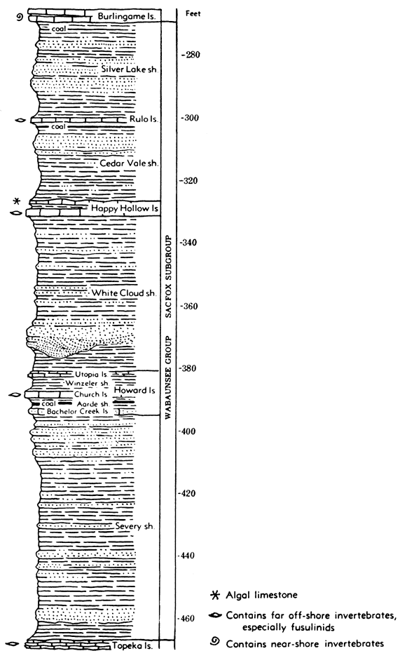
Sacfox Subgroup
Strata from the base of the Burlingame limestone to the top of the Topeka limestone are included in the Sacfox subgroup. The thickness commonly is about 200 feet.
Silver Lake shale--Gray and yellow clay shale, variably associated with platy impure limestone, sandy shale, or sandstone. Sandstone-filled channels occasionally cut downward into beds as low as the Cedar Vale shale or lower. One or more coal beds occur in the upper part. Marine invertebrates and land plant fossils are present locally. The thickness ranges from about 4 to 45 feet or more.
Rulo limestone--Bluish-gray limestone that locally is mottled with light brown when weathered. Locally a molluscan phase occurs in the lower part and a thin algal zone in the upper part. Brachiopods and bryozoans are more or less common in the more persistent part. The thickness ranges from less than 1 to about 4 feet.
Cedar Vale shale--Bluish to yellowish-brown clayey and sandy shale and sandstone with a persistent coal bed (Elmo) near the top and locally other coal beds. Marine invertebrate fossils occur above the coal. The thickness ranges from about 16 to 60 feet.
Happy Hollow limestone--Generally a single, very persistent massive bed of pinkish-brown limestone characterized by large fusulines and less plentiful other fossils. In some places there is an upper oolitic or algal bed in contact with the more persistent part or separated from it by a thin shale bed, and locally a dark bluish-gray limestone occurs a few feet below the fusuline-bearing bed. In some areas the fusuline bed is seemingly absent and the formation is represented only by algal and molluscan beds. Thickness ranges from about 1 to 8 feet or more.
White Cloud shale--Bluish-gray to yellowish-brown clayey and sandy shale. Locally sandstone and conglomerate fill channels cut downward into beds as low as the Howard limestone or lower. Sparse marine and land plant fossils are present. The thickness ranges from about 30 to 80 feet.
Howard limestone--Three limestone members and two shale members, of which the middle limestone is the most persistent. The thickness of the formation ranges from about 8 to 40 feet.
Utopia limestone member--Gray to brown limestone and sandy limestone resembling a coquina in many outcrops. Fossils include algal remains, fusulines, bryozoans, brachiopods, and mollusks. The thickness ranges commonly from less than 1 foot to a maximum of about 16 feet. Consists of two or more limestones and an ostracode-bearing shale in parts of the State.
Winzeler shale member--Bluish-gray to yellowish-gray clay shale. Marine fossils occur in the lower part. Thickness is about 1 to 12 feet.
Church limestone member--Commonly one massive bed of blue to bluish-gray limestone that weathers to a deep rich brown. Crinoid remains, productid brachiopods, and "cryptozoan" algae are more or less characteristic. A thin zone at the top contains abundant bryozoans, and fusulines occur sparingly in the upper part in southern Kansas. The thickness ranges from about 1.5 to 6 feet.
Aarde shale member--Bluish-gray to yellowish-gray clayey and sandy shale containing a very persistent coal bed (Nodaway), ranging from about 1 inch to 2 feet in thickness, and persistent black fissile shale. A hard dense vertical-jointed limestone, 3 inches to 1 foot or more thick, occurs next below the black fissile shale in many outcrops. Thickness ranges from about 2 to 15 feet.
Bachelor Creek limestone member--Commonly sparsely fossiliferous, bluish-gray, impure, sandy limestone which is present from Osage County southward. Locally two beds separated by shale. Thickness is as much as 8 feet.
Severy shale--Yellowish-brown and bluish-gray clay shale and a minor amount of platy to massive sandstone. Sparse marine fossils occur in the uppermost part and in shales below some thin limestone beds which occur in southern Kansas. A disconformity in the lower part of the Severy is indicated by various outcrops in northern Kansas. Locally, as in southern Shawnee County, sandstone fills channels cut well into the Topeka limestone. Where the Bachelor Creek limestone is absent the base of the Nodaway coal is regarded as the top of the Severy shale. The thickness is commonly 70 to 80 feet.
Shawnee Group
The Shawnee group comprises four limestone formations and three shale formations. Thick limestones and a distinctive type of cyclic sedimentation are characteristics that distinguish these rocks from those of neighboring groups. The average thickness is about 325 feet.
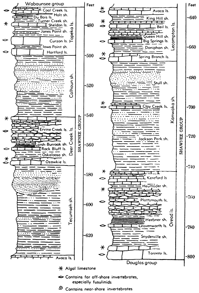
Figure 23--Virgilian (Shawnee) rocks in Kansas.
Topeka limestone--Limestones and shales having a wide range of lithology. Locally between Kansas River and Greenwood County the upper part is cut out by a disconformity in the Severy shale. In southern Kansas all members are not positively identified. In Oklahoma, the upper part of the Pawhuska formation is correlated with the Topeka limestone. The thickness of the Topeka ranges from a nearly constant measurement of 33 feet in northern Kansas to 55 feet near the Oklahoma boundary.
Coal Creek limestone member--Light bluish-gray limestone and nodular shale or dark-blue more massive limestone that weathers light bluish gray or brown. The member is not positively identified south of Kansas River, but the "red limestone" in southern Kansas is probably its equivalent. Fusulines are locally abundant and at many places numerous other well-preserved invertebrate fossils are found. The thickness of the Coal Creek limestone ranges from 2 to 5 feet.
Holt shale member--Bluish-gray shale in the upper part and black shale in the lower part. This member is not recognized with certainty south of Topeka because the limestone beds above and below it seem to disappear, at least for many miles, and because the distinctive black slaty beds do not persist southward. Shale beneath the uppermost Topeka limestone in southern Kansas probably represents the Holt member, however. Corneous brachiopods and conodonts occur in the black shale. The thickness ranges from 1.5 to 3 feet.
Du Bois limestone member~One or more dark-blue or greenish-blue fine-grained, somewhat earthy limestone beds with prominent vertical jointing. Not definitely recognized south of Topeka. Mollusks and brachiopods are common. The thickness commonly ranges from about 0.5 to 2 feet.
Turner Creek shale member--Bluish or greenish-gray clayey and calcareous shale, bearing few invertebrate fossils. The thickness ranges from 1 to 5 feet in northern Kansas; shale in southern Kansas that is correlated with the Turner Creek measures 12 to 15 feet.
Sheldon limestone member--A massive light-gray to nearly white, very fine-grained, dense limestone that commonly contains numerous small algal growths of the type known as Osagia. The rock weathers light yellowish gray and makes smooth rounded surfaces at the outcrop. The member is a persistent layer that is identified northward from Kansas River but seemingly is absent to the south as far as Greenwood County; in southern Kansas there is an algal limestone at the Sheldon horizon. Thickness ranges from 0.7 to 2 feet.
Jones Point shale member--Clayey, calcareous, and silty gray shale, locally containing nodular or platy limestone beds. The member contains fairly numerous brachiopods and mollusks at some outcrops but is poor in fossils at many exposures. The thickness in northern Kansas ranges from 1 to 10 feet, but beds in Elk and Chautauqua Counties that are correlated with the Jones Point shale are 10 to 15 feet.
Curzon limestone member--This is a persistent prominent subdivision of the Topeka formation that is readily and positively identifiable throughout northern Kansas. It consists of two or more beds of massive bluish-gray, brown-weathering limestone that is mostly hard and resistant, forming a well-marked escarpment. Nodules of chert are common. Fusulines occur sparingly to very abundantly in the lower and middle parts of the member, together with some brachiopods and other invertebrates; bryozoans and echinoid remains are common in upper layers. The thickness ranges from 5 to 12 feet.
Iowa Point shale member--Yellowish-gray to bluish-gray, clayey to calcareous shale that locally contains sandstone layers and a thin coal bed. This shale is typically developed and thickest in northern Kansas near the Nebraska boundary. in sections near Topeka it is only 2 feet thick, and farther south it disappears, as indicated by fusuline-bearing lower layers of the Curzon resting directly on the algal upper part of the Hartford limestone. Thickness, a featheredge to 14 feet.
Hartford limestone member--Massive, light bluish-gray limestone that weathers brownish. This member commonly bears numerous fusulines except in the upper part, which contains numerous Osagia and is of algal origin. The lower beds are characterized by presence of the chambered sponge, Amblysiphonella. The upper algal limestone is highly variable in thickness, ranging from almost nothing to 12 feet. The thickness ranges from about 3 to 13 feet.
Calhoun shale--Clayey and sandy shale, a minor amount of limestone, and one or more coal beds. In northern Kansas, a thin coal bed and much sandstone, a part of which fills channels, occur near the top of the formation. Dark-gray, silty, fossiliferous shale comprises the lower part, and plant remains occur in the sandy part. In southern Kansas, the shale progressively diminishes in thickness until near the Oklahoma boundary it is locally absent. In northern Kansas, near the Nebraska line, the Calhoun is only 10 feet thick. Maximum thickness of this shale, about 45 feet, is developed near Kansas River.
Deer Creek limestone--A persistent, escarpment-making formation comprising three limestone members and two shale members. Lithologic characters are fairly constant. The thickness ranges from about 20 to a local abnormal maximum in Osage County of 80 feet.
Ervine Creek limestone member--Mainly composed of light-gray to nearly white or bluish-gray fine-grained limestone characterized by thin, wavy bedding that locally contains chert nodules. It bears a large assemblage of invertebrate fossils, including fusulines, corals, echinoid and crinoid fragments, bryozoans, brachiopods, and mollusks. Shale partings contain ostracodes and small foraminifers. The thickness ranges from about 5 to 32 feet. Above the wavy-bedded limestone is a less persistent limestone, generally massive, that is variable in lithology. Locally it is oolitic; elsewhere it is coquinoid, nodular, very fine-grained, or sandy; the alga called Osagia is common. This limestone, which ranges from a featheredge to about 6 feet, is generally separated from the underlying limestone by 1 to 2 feet of yellowish clayey to sandy shale but the shale is absent in many places.
Larsh-Burroak shale member--Gray or yellow clayey shale in the upper part and black, more or less fissile shale in the lower part. Fossils are rare in the upper part but conodonts occur in the black portion. Thickness ranges from about 2.5 to 7 feet.
Rock Bluff limestone member--Massive, vertical-jointed bed of dark-blue limestone that develops a bluish-gray or creamy surface film on weathering. Fusulines are common; a few brachiopods and other marine invertebrates are present. The thickness ranges from about 1 to 3 feet.
Oskaloosa shale member--Bluish or yellowish-gray shale in northern Kansas and sandy micaceous shale containing a red zone and some nodular limestone in the southern part of the State. The thickness, ranges from an observed minimum of 3 feet to a maximum of about 50 feet locally in Osage County.
Ozawkie limestone member--Brownish-gray, brown-weathering, massive limestone. Fossils are somewhat sparse, but fusulines and other marine fossils are abundant in some outcrops. Commonly the thickness is about 5 feet but ranges from about 1 to 20 feet.
Tecumseh shale--Chiefly clayey and sandy shale, locally having a more or less discontinuous limestone (Ost) in the upper part. This limestone is not persistent enough to call for subdivision of the formation as in Nebraska. Sandstone is locally present not far below the Deer Creek limestone. The thickness of the Tecumseh ranges from an observed minimum of 12 feet in southern Kansas to a maximum of about 65 feet near Kansas River.
Lecompton limestone--Four limestone members and three shale members, all of which can be traced across Kansas, make up this formation. The thickness ranges from about 30 to 50 feet.
Avoca limestone member--Dark bluish-gray somewhat earthy limestone occurring in one or more beds. Large fusulines are the most common fossils. In southern Kansas a "cryptozoan"-bearing limestone is a characteristic element of the member. Algal-molluscan limestone beds occur at the top of the Avoca in some outcrops. The thickness ranges from about 1 to 20 feet.
King Hill shale member--Bluish-green to reddish-gray shale, calcareous in northern Kansas. Brachiopods occur in the upper part. The thickness range is from about 4 to 20 feet.
Beil limestone member--Alternating beds of hard bluish-gray limestone, weathering yellowish, and calcareous shale, or light-gray, nearly white, wavy-bedded limestone in southern Kansas. Algal limestone resembling an oolite comprises the upper part in northern Kansas. Corals and fusulines are abundant and characteristic. The thickness ranges from about 4 to 15 feet.
Queen Hill shale member--Bluish-gray or yellow shale in the upper part; hard black fissile shale, bearing conodonts, in the lower part. The thickness ranges from about 3 to 6 feet.
Big Springs limestone member--Dark bluish-gray dense limestone, commonly occurring as a single bed with prominent vertical jointing. Locally two or three limestone beds separated by shale. Weathering produces a yellowish-brown film. Fusulines are abundant. The thickness ranges from about 1 to 5 feet.
Doniphan shale member--Shale, sandstone, and thin limestone beds. Thicker and contains some red shale and prominent sandstone beds in southern Kansas. Fusulines are plentiful in the basal part at some exposures. Thickness ranges from about 5 to 34 feet.
Spring Branch limestone member--Gray, somewhat sandy limestone that weathers deep brown and occurs in massive slightly uneven beds. Fusulines are abundant in most outcrops. In northern Kansas the thickness is commonly 5 feet; in southern Kansas this member locally is very sandy impure limestone about 4 feet thick.
Kanwaka shale--In northern Kansas, divisible into two shale members and a limestone member. In southern Kansas, much of the interval between the Lecompton and Oread formations is occupied by sandstone, sandy shale, and red shale, collectively called Elgin sandstone. Thickness ranges from about 40 to 145 feet.
Stull shale member--Yellowish-brown sandy shale, locally one or more coal beds. Sandstone containing somewhat plentiful land plant fossils and partly filling channels occurs in the upper part in northern Kansas and much or all of the Elgin sandstone in the southern part of the State may belong in this division. The Stull shale is identified definitely in Kansas northward from the central part of the State and tentatively in parts of southern Kansas. The thickness ranges from about 25 to at least 45 feet.
Clay Creek limestone member--Dark-blue to bluish-gray limestone, commonly massive and dense; vertical jointing is characteristic. Fusulines are locally abundant and other fossils are fairly plentiful. Locally oolitic, algal, and crinoidal deposits occur above the more persistent part. The Clay Creek limestone is persistent in northern Kansas at least as far southward as Osage County and is tentatively identified in Greenwood and Elk counties as a zone of fossiliferous and calcareous sandy shale. The thickness may be as much as 5 feet.
Jackson Park shale member--Bluish-gray and yellowish-brown sandy shale and sandstone. Land plant fossils are more or less abundant. Locally in Douglas County, a thin coal bed and clam-bearing sandy layers occur in the upper part. This and higher subdivisions of the Kanwaka here named are not so definitely differentiated in southern Kansas. The observed thickness ranges from 16 to 52 feet.
Oread limestone--The basal formation of the Shawnee group comprises four limestone members and three shale members, the outcrop of which is marked by a prominent escarpment across the State from Doniphan County, in the north, to Chautauqua County, in the south. The average thickness in northern and central Kansas is 52 feet; in southern Kansas the thickness increases to about 100 feet owing mainly to expansion of the interval between the lower two limestone members.
Kereford limestone member--This member is variable in lithology, commonly more or less oolitic or fine-grained and flaggy. In northern Kansas, upper slabby cross-bedded layers, containing algal and locally land plant remains, overlie more massive rock that contains fusulines and other marine invertebrates. At some outcrops the member consists of a single bed of dark bluish-gray dense limestone; elsewhere, especially in Osage County, it is made up of dense bluish flaggy limestone partly interbedded with shale. The Kereford is not recognized in southern Kansas. Thickness ranges from a featheredge to more than 40 feet.
Heumader shale member--Commonly dark-gray shale, locally bluish or greenish, clayey to silty, and in southern Kansas sandy. Well-preserved mollusks and other fossils occur commonly. Thickness in northern Kansas ranges from 2 to 5 feet.
Plattsmouth limestone member--The Plattsmouth is the main limestone member of the Oread formation. Commonly it is light bluish-gray, light-weathering, dense limestone that occurs in wavy beds. Flint is more or less abundant in the northern part of the outcrop. Fossils include fusulines, corals, bryozoans, brachiopods, sparse mollusks, and other invertebrates. Algal remains occur locally at the top. The thickness ranges from 2 feet in southern Greenwood County to 23 feet in Atchison County; in southern Kansas the member is commonly 15 to 20 feet thick.
Heebner shale member--In many outcrops this member consists of four distinct shale units which are, in descending order: calcareous clay shale, dark bluish-gray shale, black platy shale, and a thin bed of gray or yellow clay shale. The black platy shale is almost everywhere the thickest part, but is commonly less than 3 feet. Small brachiopods occur in the upper part, conodonts are found in the black shale, and locally there are numerous gastropods in the thin film of clay at the base of the member. The thickness of the Heebner shale across Kansas is very constant, ranging from 5 to 7 feet. It is also a widely distributed marker in the subsurface, which is identified in radioactivity logs by its very strong gamma ray emanations.
Leavenworth limestone member--A dark bluish-gray, dense, massive limestone occurring in a single bed having prominent vertical joints. Fusulines and brachiopods are the most common fossils. Almost everywhere across Kansas the thickness is more than 1 and less than 2 feet.
Snyderville shale member--Gray and bluish-gray clay and in part red shale. In northern Kansas, it is largely a structureless underclay-like deposit; in southern Kansas, it is partly red and sandy and locally contains sandstone and impure nodular limestone. Marine fossils especially Chonetes occur in the uppermost part; in southern Kansas other zones are also fossiliferous. The thickness in the northern part of the State averages about 12 feet, but it increases to about 75 feet in southern Kansas.
Toronto limestone member--Brownish-gray massive limestone that weathers deep brown. Locally flinty or algal limestone occurs in the upper part. The Toronto is typically developed from Woodson County northward but is thinner and sandy or locally absent in southern Kansas. The member is absent also in part of southern Douglas County, where a limestone conglomerate occupies its approximate stratigraphic position. Fusulines, corals, and small brachiopods are the most common fossils. The thickness of the Toronto in northern Kansas ranges from 8 to 12 feet; in southern Kansas it is generally less than 4 feet.
Douglas Group
The Douglas group underlies the Shawnee group conformably, except possibly in southern Douglas County. It comprises chiefly clastic rocks, shale, and sandstone. Limestone, coal, and conglomerates are quantitatively of minor importance. The thickness is approximately 250 feet.
Figure 24--Virgilian (Douglas) rocks in Kansas.
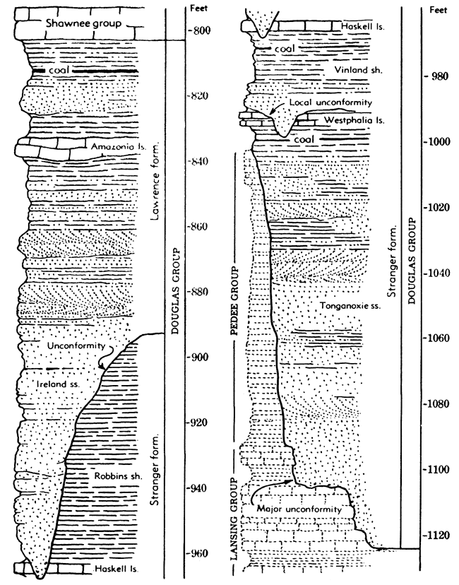
Lawrence shale--Blue-gray and yellowish shale, tan-colored sandstone, and a minor amount of coal, limestone, and conglomerate comprise the Lawrence shale. The formation extends from the base of the Toronto limestone to the disconformity below the Ireland sandstone or, in places where the disconformity is undeterminable, to the top of the Haskell limestone. Except for members known as the Amazonia limestone and Ireland sandstone, which are somewhat impersistent, the Lawrence shale is not subdivided. The thickness ranges from about 40 to 175 feet.
Amazonia limestone member--This is typically a light-gray, dense, hard limestone occurring about 25 or 30 feet below the top of the Lawrence shale. Locally it is partly coquinoid or brecciated in appearance. Outcrops are found in Doniphan, Atchison, Franklin, Coffey, and Woodson counties and possibly farther south. In Franklin County and vicinity, the Amazonia occurs a few feet below the Williamsburg coal, which is mined at several places. Sponges are locally common in the member (Atchison County) and fusulines occur in limestone that may be Amazonia in southern Kansas. Fossils are not abundant generally. Thickness ranges from a featheredge to about 13 feet. In the southern outcrop area it averages about 1.5 feet.
Ireland sandstone member--Light- buff or tan thin-bedded and massive sandstone, in part cross-bedded. Where thickest, the sandstone lies above a disconformity, which is identified in many places but seemingly is not continuous. In some places, especially where the Ireland cuts out the Haskell limestone and still lower beds, a limestone conglomerate is found at the base of the sandstone. The upper boundary is somewhat indefinite, because much sandy shale and thin-bedded sandstone occur in the upper part of the Lawrence shale. Local coal beds are associated with these sandy sediments. In Woodson County, the top of the Ireland sandstone is only a few feet below the Amazonia limestone. The thickness of the Ireland sandstone ranges from a featheredge to 100 feet or more.
Stranger formation--Light-tan to yellowish-gray sandstone and shale and a minor amount of limestone, coal, and conglomerate. Thickness ranges from 40 to 220 feet.
Robbins shale member--Gray and yellowish-gray marine shale, locally cut out and overlapped by the Ireland sandstone in Franklin County and the southern part of Douglas County. This member is essentially restricted to areas southward from Woodson County. Phosphatic concretions occur in a zone at the base in the northern part of the outcrop area. Thickness ranges from a featheredge to 110 feet.
Haskell limestone member--Bluish-gray fine-grained limestone, locally having oolitic layers at the top and base. Pelecypods and gastropods occur in the oolitic facies. The main part bears algal remains, fusulines, and brachiopods. In parts of Douglas and Franklin counties, the Haskell limestone is cut out and overlapped by Ireland sandstone. The thickness ranges from a featheredge to about 10 feet.
Vinland shale member--Gray, clayey, calcareous, and sandy shale and locally some sandstone underlying the Haskell is named the Vinland shale. Locally in Woodson County, a dark-green layer occurs in the middle part. North of Anderson and Coffey counties, where the Westphalia limestone is absent, the top of the Upper Sibley coal is regarded as marking the base of the Vinland shale. A disconformity beneath a sandstone at the base of the Vinland cuts out the Westphalia limestone locally in Coffey County. The thickness of the Vinland shale member ranges from about 9 to 50 feet.
Westphalia limestone member--A limestone characterized by abundant fusulines; not definitely recognized north of T. 19 S., but fairly persistent in southern Kansas. A limestone slightly above the Upper Sibley coal in Douglas and Leavenworth Counties probably represents this limestone. The thickness of the member ranges from a featheredge to about 5 feet.
Tonganoxie sandstone member--Massive cross-bedded sandstone and sandy shale, containing several discontinuous coal beds, form the lower part of the Stranger formation in most places. The Upper and Lower Sibley coals, in the northern part of the outcrop area, are the most important coal beds of the unit. The top of the Tonganoxie member is rather indefinite, but in general the base of the Westphalia limestone or the top of the Upper Sibley coal bed is defined as the boundary. Locally, limestone conglomerate occurs at the base. Like the Ireland sandstone, the Tonganoxie is more massive and is thicker in southern Kansas, where the two sandstones form the Chautauqua Hills escarpment. The thickness ranges from a featheredge to 90 feet.
A disconformity below the Tonganoxie sandstone brings deposits classified as lowermost Virgilian into contact with rocks ranging downward from the Iatan limestone, or perhaps a little higher, at least to the lower part of the Stanton limestone. Paleontological evidence indicating a significant hiatus in sedimentation and evidence of widespread, though not great, erosion support placement of the Missourian-Virgilian boundary in this position. The disconformity is obscure in the northern midcontinent area but it corresponds to the prominent nonconformity in southern Oklahoma that records erosion of mountains formed by the Arbuckle orogeny.
Figure 25--Selected stratigraphic sections of Wabaunsee and Shawnee rocks.
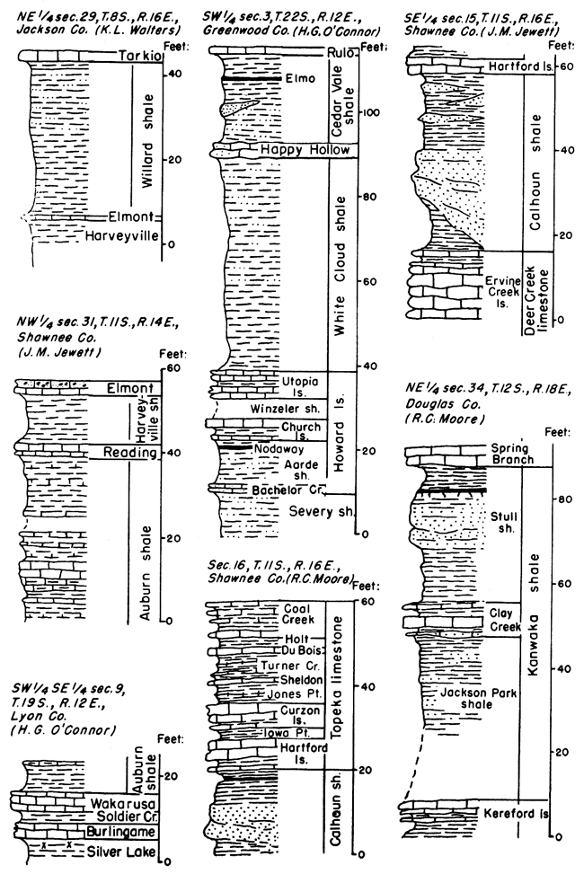
Figure 26--Selected stratigraphic sections of Shawnee rocks.
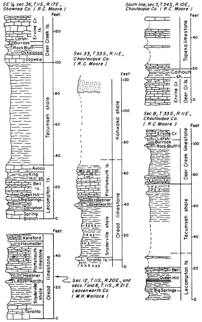
Figure 27--Sections of Wabaunsee beds showing cyclothems. Corresponding phases of the cyclothems are correlated. The stratigraphic position of the cyclothems is indicated in the general section in Figure 28. Read Pierson Point shale for Wamego shale.
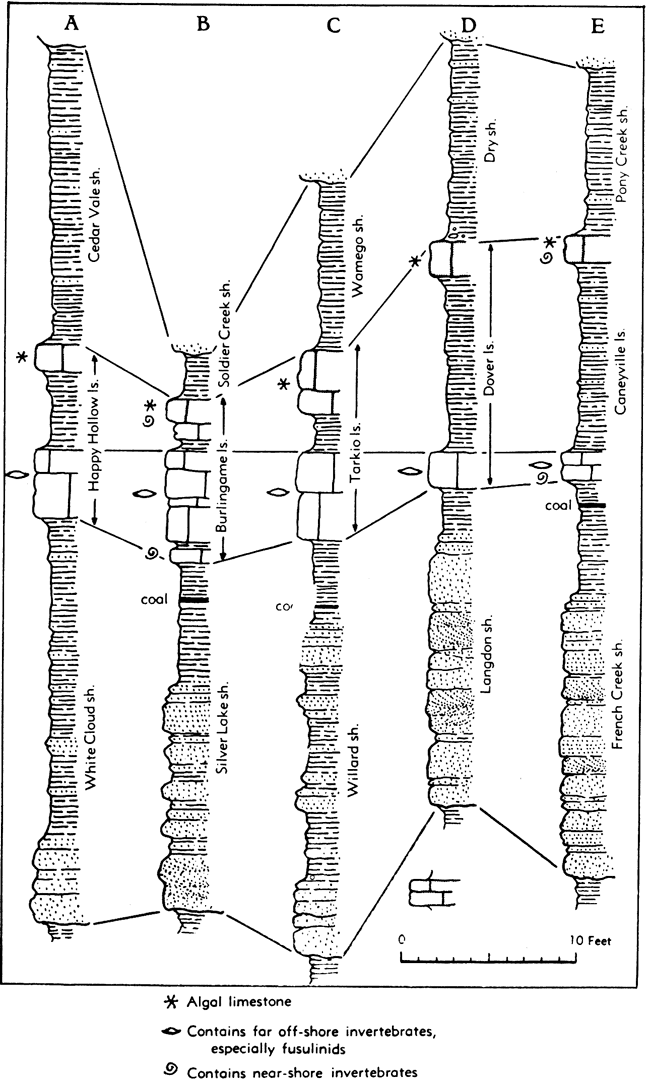
Figure 28--Sections of Wabaunsee beds showing cyclothems. Read Pierson Point shale for Wamego shale.
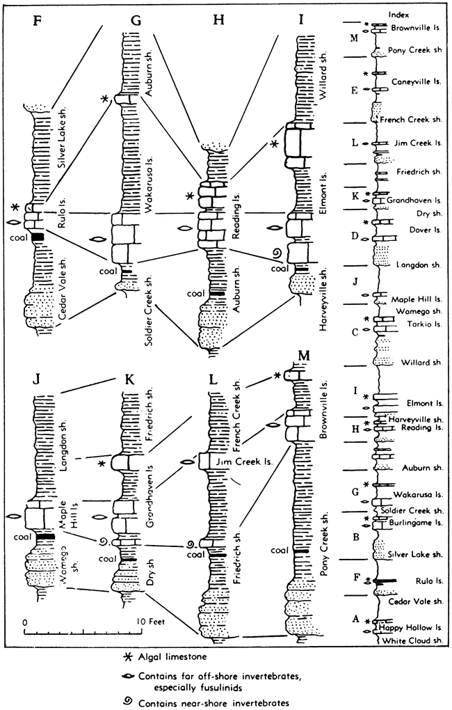
Figure 29--Sections of upper Lansing and lower Shawnee beds showing cyclothems and megacyclothems. The cyclothems are indicated by the letters A-E. Megacyclothems include the entire sequence of beds in any one of the three plotted sections R, S, T. Stratigraphic position of the sequences is indicated on the general section in Figure 30.
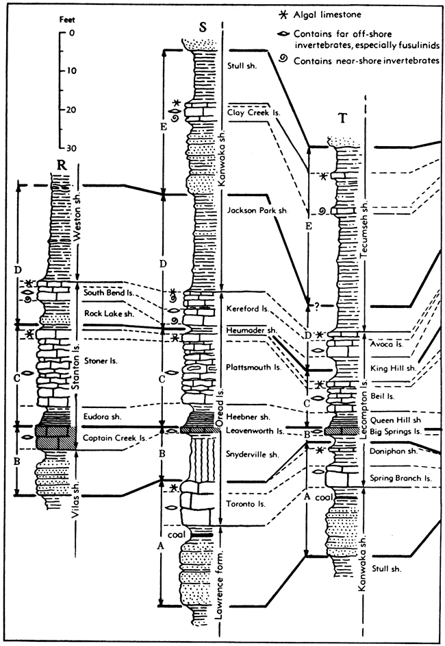
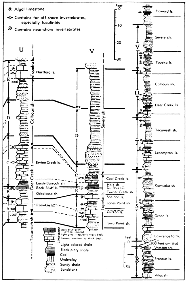
Figure 30--Sections of upper Shawnee beds showing cyclothems and megacyclothems. The cyclothems are indicated by the letters A-E. Megacyclothems include the entire sequence of beds in any one of the plotted sections U or V.
Missourian Series
Upper Pennsylvanian rocks of Kansas, classed as belonging to the Missourian Series, lie between two regional disconformities that form boundaries between this division and adjoining strata. The Missourian deposits are essentially distinguished by paleontologic characters and to some extent by peculiarities of cyclic sedimentation. The outcrop area of this series in Kansas is a 20- to 40-mile wide belt, marked by fairly strong east-facing escarpments, extending from Doniphan County in the northeast to Montgomery County in the south. The thickness is about 700 feet.
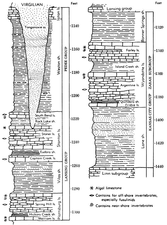
Figure 31--Missourian (Pedee, Lansing, and Kansas City) rocks in Kansas.
Pedee Group
This topmost division of the Missourian rocks includes the Weston shale below, the Iatan limestone above, and possibly a few feet of sandy and clayey shale above the Iatan limestone. These beds, occurring between the Stanton limestone and the disconformity that defines the top of the Missourian Series, are classified as a separate group, because the conformably underlying Lansing group is a compact unit consisting mainly of limestone. Average thickness is 90 feet.
Iatan limestone--Light bluish-gray or nearly white limestone. The texture is very fine and dense, but there are numerous thin, irregular plates of clear calcite. Fossil remains are not abundant, but fusulines, brachiopods, bryozoans, crinoid fragments, and small corals are somewhat common locally; algal remains are abundant in the upper part at many places. The formation is extensive in northeastern Kansas but is cut out by the post-Missourian disconformity near Leavenworth and southward at least to the vicinity of southern Douglas County. The thickness ranges from about 4 to 22 feet.
Weston shale--Dark bluish to bluish-gray clay shale, generally unfossiliferous but containing thin fossiliferous limestone beds locally. There are some beds of shaly and even-bedded sandstone toward the south. In many places the formation is characterized by flattish, elliptical concretions of ironstone. At many places the post-Missourian disconformity has cut out most or all the Weston shale. The thickness ranges from a featheredge to 200 feet.
Lansing Group
This part of the Missourian includes a rather compact assemblage of two limestones and a thin shale formation. It makes an escarpment that is traced readily across Kansas. The group is recognizable in the subsurface of the eastern and central parts of the State, but in western Kansas it is clearly separable from underlying Kansas City beds. The thickness averages about 85 feet.
Stanton limestone--Three limestone and two shale members. In northeastern Kansas the formation is rather uniform in character and thickness, but in east-central and southern Kansas there are great local variations. Near the Oklahoma-Kansas boundary, the Stanton is difficult to trace. The thickness of the formation ranges from about 10 to 90 feet. The characteristic thickness is about 42 feet.
South Bend limestone member--The topmost division of the Stanton is composed of dark-gray fine-grained limestone. The lower part is sandy and locally contains some sandy shale. Fusulines and the brachiopod Meekella are the most common fossils. The thickness is rather constantly about 5 feet.
Rock Lake shale member--Chiefly sandy shale and soft buff sandstone, and commonly a thin layer of greenish or gray clay shale in the lower part. In Anderson County the Rock Lake member locally contains an assemblage of well-preserved land plants, including Walchia, mixed with remains of amphibians, fishes, a scorpion, and marine invertebrates. The sandstone is generally even-bedded or massive, and contains marine fossils, mostly mollusks. Locally a disconformity at base. The thickness ranges from about 1 to 15 feet.
Stoner limestone member--Light bluish-gray to nearly white, mostly thin wavy-bedded limestone having thin shale partings between the layers. The rock is fine-grained, but locally there is much crystalline calcite. It is generally sparingly fossiliferous, but to the north it contains abundant Triticites. This limestone makes a rather prominent escarpment in Kansas. It ranges in thickness from 11 to 40 feet.
Eudora shale member--Dark-gray and black fissile shale in the lower part and greenish-gray to bluish-gray clay shale in the upper part. Abundantly fossiliferous in northern Kansas but barren of megascopic fossils in northeastern Kansas. Thickness is locally 1 or 2 feet in some northern exposures and as much as 50 feet in part of Montgomery County.
Captain Creek limestone member--Dark to bluish-gray, granular or dense, brittle limestone. It is massive or even-bedded and in most places shows vertical joints. The upper few inches in some exposures is a brecciated silicified mottled pink and gray bed. The brachiopod Enteletes pugnoides is abundant and the fusuline Triticites neglectus occurs commonly on bedding planes. Characteristic thicknesses along Kansas River range from 4.5 to 5.5 feet. Locally in Miami County it is a little more than 10 feet thick, and near Independence, in Montgomery County, limestone 55 feet thick has been assigned to this member.
Vilas shale--Gray to buff clayey and sandy shale, sparsely fossiliferous. Locally along Kansas River, hard gray ripple-marked sandstone occurs in the upper part and farther south a considerable thickness of reddish-brown soft sandstone is found in some exposures. The thickness in the Kansas River Valley and northward is about 15 feet, but to the south the thickness locally increases to 90 feet.
Plattsburg limestone--Two limestone members separated by a shale member. The upper limestone is the most prominent, except locally as in eastern Franklin County. The thickness of the formation ranges from a a featheredge to more than 100 feet at a few places in southern Kansas. The formation disappears near the Oklahoma line, but seemingly reappears farther south and is represented in the upper part of the Ochelata group. Average thickness of the Plattsburg limestone in Kansas is about 23 feet.
Spring Hill limestone member--Bluish-gray, fine-grained, brittle, thin-bedded limestone in the lower part and light-gray algal (oolitic) or granular limestone in the upper part. Characteristic fossils include algal remains, several species of sponges, echinoid spines, and the brachiopods Marginifera, Enteletes, a robust Composita, Neospirifer, and Isogramma. The thickness ranges from 8 to 50 feet or more but commonly is about 15 feet.
Hickory Creek shale member--Gray, green, and black shale. Where thin (0.5 to 2 feet), this member contains a black carbonaceous zone, and where thick (to 15 feet), it is mostly gray or yellowish in color and is clayey. Fossils are rare or lacking in this shale. The thickness in many places is less than 1 foot but about 5 feet is more common.
Merriam limestone member--Commonly the lower part of this member is drab or light-gray limestone and the upper part is bluish-gray fine-grained limestone. Locally, because of accumulation of algal and granular limestone in the uppermost part, the Merriam is thicker than the overlying Spring Hill limestone. Numerous productids and a few other brachiopods are characteristic. Several species of nautiloid cephalopods are found in Franklin County where the member contains much algal (oolitic) limestone. The thickness ranges from less than 1 foot to about 10 feet (eastern Franklin County).
Kansas City Group
As now defined, the Kansas City group includes strata from the base of the Hertha limestone to the base of the Plattsburg limestone. Three subgroups are recognized. The Kansas City group is about 350 feet thick in the latitude of Iola and about 325 feet thick in the Kansas City area.
Figure 32--Missourian (Kansas City and Pleasanton) rocks in Kansas.
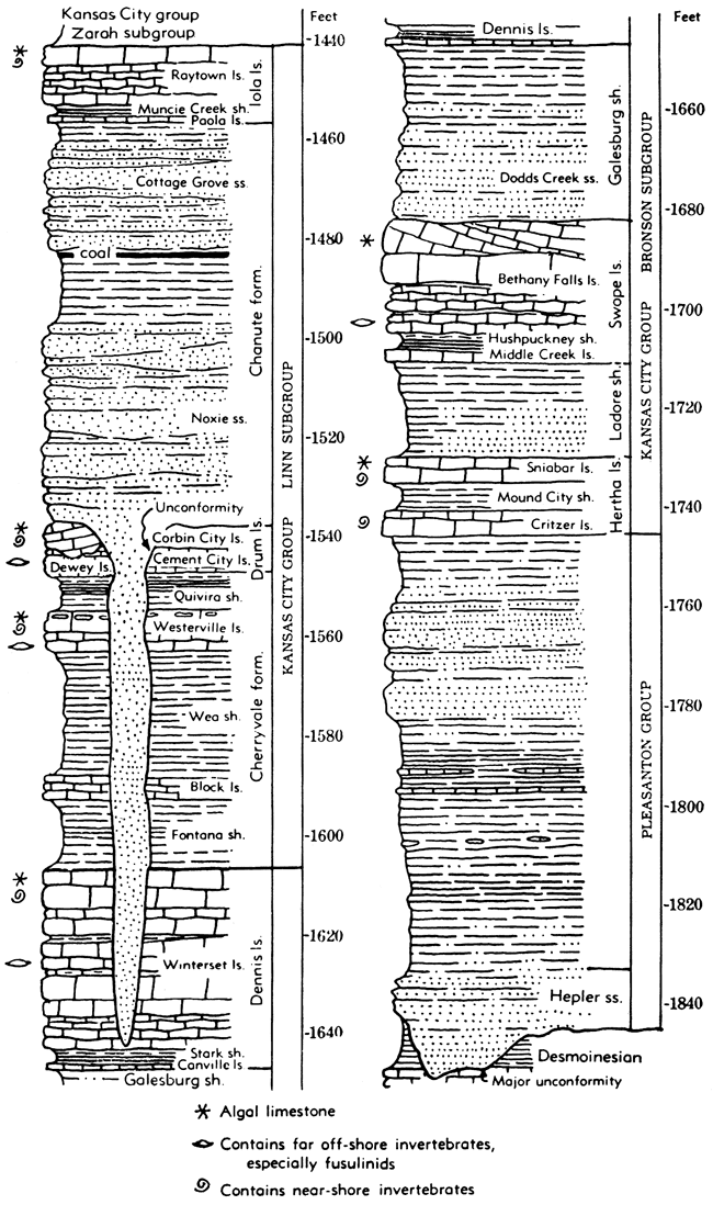
Zarah Subgroup
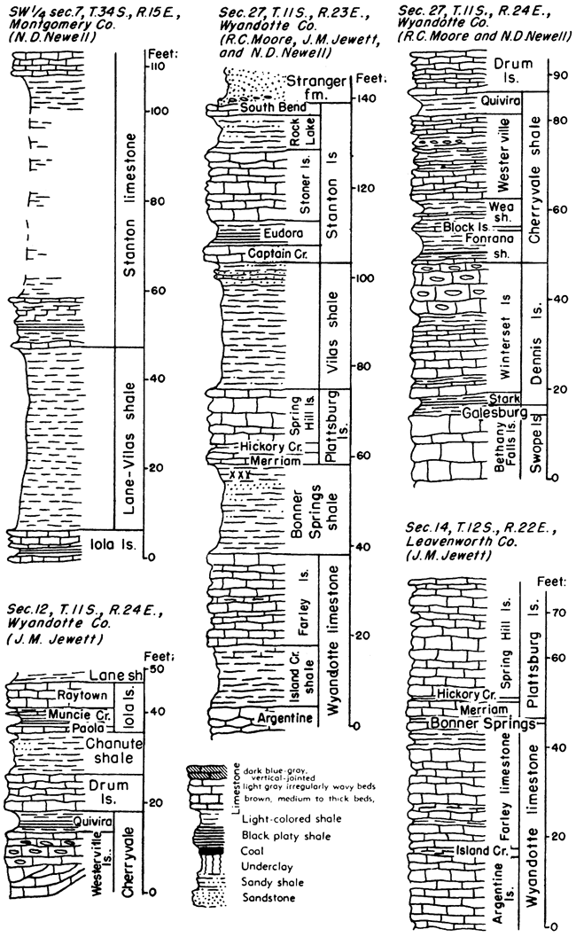
The upper part of the Kansas City group, comprising approximately one-third of the section, is designated as the Zarah subgroup. It includes beds between the top of the Iola formation and base of the Plattsburg formation. Near Kansas City, this interval is mainly characterized by prominent limestone members of the Wyandotte formation, occurring between the relatively thin Lane shale and Bonner Springs shale, which comprise the lower and upper parts of the subgroup, respectively. The thickness of subdivisions varies greatly from place to place. Average thickness of the subgroup in Kansas is about 100 feet.
Bonner Springs shale--This formation consists of gray to buff shale, sandy shale, and sandstone. The upper part of the shale consists of olive-green clay shale containing a maroon band near the top in the northern part of the outcrop area. Soft, nodular, cavernous limestone commonly overlies the maroon shale. Sandstone is rather prevalent in the lower part of the Bonner Springs shale, and in some exposures it occupies definite channels cut in clay shale. Southward from southeastern Franklin County where the underlying Wyandotte limestone disappears, the Bonner Springs shale rests directly on Lane shale, and beds between the Iola and Plattsburg limestones are designated as Lane-Bonner Springs shale. The thickness of the Lane-Bonner Springs ranges from 55 to 170 feet. Locally along Kansas River, the Bonner Springs shale is absent; the maximum observed thickness is 60 feet in T. 17 S., R. 20 E.
Wyandotte limestone--Three limestone and two shale members. The lower two limestones and their separating shale are are more constant in lithologic character and thickness, but the entire formation, which is prominent in northeastern Kansas and especially along Kansas River, disappears a short distance southwest of Lane in southeastern Franklin County. It reappears as thin limestone and sandstone beds a few miles north of Garnett in Anderson County, but can be identified for only a few miles. The thickness ranges from a featheredge to 75 feet.
Farley limestone member--This member comprises an extremely variable assemblage of limestone and shale beds that is recognized only north of T. 14 S. Many types of limestone are represented, but oolitic-appearing algal limestone, limestone breccia or conglomerate, and dense mottled pinkish-gray limestone are characteristic. A thin bed of dark greenish-gray sandy shale containing a molluscan fauna occurs rather persistently in the middle part. Cross bedding is common, both in algal limestone and in breccia. The algal and oolitic facies commonly occur in massive beds; the breccias and conglomerates are slabby. Wavy and thin-bedded, mottled, dense limestone, chiefly in the lower part, is somewhat similar to the main body of the underlying Argentine limestone. The Farley limestone is abundantly fossiliferous. mollusks predominating. The relative quantitative importance of limestone and shale in this member varies from place to place. Thickness ranges from a featheredge to about 35 feet.
Island Creek shale member--A gray, yellow, and bluish clay shale of highly variable thickness. Locally in Wyandotte County, several feet of sandstone, seemingly a channel filling, occupies this position. The thickness ranges from a featheredge to about 40 feet.
Argentine limestone member--This is a prominent escarpment-making light bluish-gray limestone, much of which weathers creamy white. Wavy bedding is common; clay partings are numerous in some outcrops. Marine fossils are plentiful. The thickness ranges from a featheredge to 35 feet.
Quindaro shale member--Black fissile yellowish-gray calcareous shale or soft shaly limestone, 1 to 4 feet thick
Frisbie limestone member--Bluish-gray to dark-blue massive limestone, locally bearing numerous marine fossils. The thickness commonly ranges from 1 to 3 feet.
Lane shale--Dark bluish-gray clay shale, commonly containing rather abundant marine fossils; gray and yellowish-brown unfossiliferous sandy shale, and thin-bedded sandstone. The thickness ranges from about 15 to 105 feet. Southward from the point where the Wyandotte limestone pinches out, the Lane and Bonner Springs shales merge. The thickness of the combined units (Lane-Bonner Springs shale) ranges from about 55 feet to 170 feet locally in Allen County. Average thickness of the Lane shale is about 50 feet.
Linn Subgroup
Named from prominent outcrops in western Linn County, the middle division of the Kansas City group is designated Linn subgroup. It comprises strata from the top of the Iola formation to the top of the Dennis limestone. These deposits are well defined in all parts of the outcrop area except locally in parts of southern Kansas where a disconformity at or near the base of the Chanute shale brings upper Zarah deposits in contact with beds as low as the basal part of the Dennis formation. The subgroup is characterized by relative prominence of shales, persistent limestones, and locally much sandstone. The average thickness is about 110 feet.
Iola limestone--Two limestone members and a shale member. The upper limestone is the most conspicuous part of the formation. The thickness ranges from a featheredge along the Kansas-Oklahoma line and locally elsewhere in southern Kansas to about 30 feet in Allen County. In northeastern Kansas the thickness commonly is about 7.5 feet.
Raytown limestone member--Light-gray wavy-bedded limestone throughout much of the outcrop area; dark-gray to buff more massively bedded limestone in the Kansas River Valley, where abundant light-colored large fossil shells give the rock a mottled appearance. Deposits of algal and crinoidal material ranging in thickness from a mere crust, as in the Kansas City area, to several feet in Allen County, occur commonly in the upper part of the member. The thickness in the Kansas City area is about 5 feet, in Miami County 6 feet, and in the vicinity of Iola 28 feet. It thins southward from Allen County and is absent locally in southern Kansas, but reappears in northern Oklahoma where it is named the Avant limestone.
Muncie Creek shale member--Black fissile shale overlain by gray or buff shale containing abundant phosphatic nodules. The thickness commonly ranges from about 1 to 3 feet.
Paola limestone member--Dark bluish-gray, massive-bedded, brittle, vertical-jointed limestone that weathers bluish-gray. "Worm borings," which are irregular subcylindrical bodies that differ slightly in color and texture from surrounding rock matrix, are more or less characteristic. The thickness ranges from a featheredge to about 2 feet.
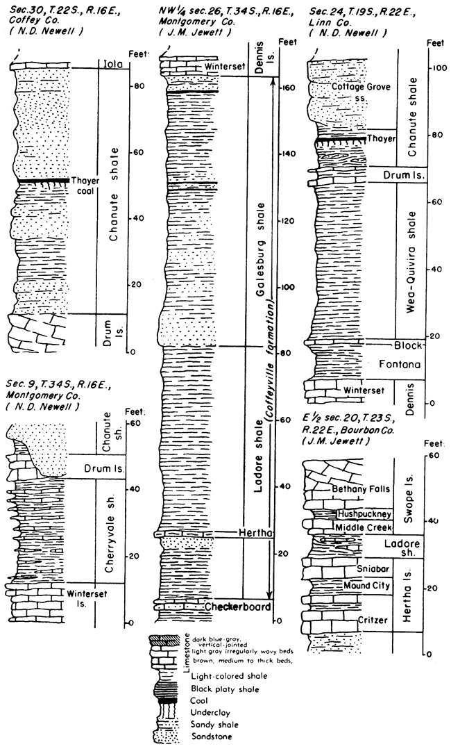
Chanute shale--Yellowish-brown sandy shale and dark-gray to greenish shale, sandstone, and one coal bed. The sandy shale and sandstone occur chiefly in the upper part, above the coal bed. Members have been differentiated in southern Kansas but are not distinguished north of Allen County. The thickness of the Chanute shale ranges from 12 feet near Kansas City to 165 feet in southern Kansas.
Cottage Grove sandstone member--Yellowish-brown or tan thin-bedded to massive sandstone makes up the upper one-third to one-half of the Chanute shale in southeastern Kansas, but this sandstone occurs only locally in northeastern Kansas. Thickness ranges from a featheredge to 60 feet.
Unnamed Clay Shale, locally calcareous and nodular or sandy, occurs in the lower middle part of the Chanute shale. The persistent Thayer coal, or a thin bed of underclay, is commonly found at the top of this shale, next below the Cottage Grove sandstone. The Thayer coal ranges in thickness from less than an inch to 2.5 feet. The unnamed shale is 10 to 75 feet thick, the maximum being observed in places where the Noxie sandstone is absent.
Noxie sandstone member--Sandstone at the base of the Chanute shale, commonly filling channels that extend as low as the Stark shale or perhaps lower, is known as the Noxie sandstone member. Locally a limestone conglomerate occurs at the base. This member of the Chanute is recognized only in south-central and southern Kansas where the thickness locally reaches 100 feet.
The disconformity at the base of the Noxie sandstone is recognized at many places in southern Kansas, especially from T. 28 S. southward.
Drum limestone--Two limestone members locally separated by a thin shale. The thickness ranges from a featheredge to about 60 feet. Throughout most of the outcrop area, however, the formation is less than 10 feet thick.
Corbin City limestone member--Chiefly light-gray oolitic cross-bedded limestone that is highly fossiliferous. This member is best developed in the vicinity of Independence, where it is 50 feet or more thick. It is represented by a few feet of limestone conglomerate in southern Kansas near Coffeyville and by 1 foot or less of chiefly algal limestone in the Kansas City area. Fossils are abundant in the thick oolitic facies. A few inches of shale that lies between these two limestones at some exposures is included with the Corbin City member. In southern Kansas, the Corbin City limestone rests disconformably on the Dewey limestone. In the vicinity of Cherryvale in Montgomery County the oolitic limestone of the upper member fills hollows nearly 5 feet deep in the lower limestone.
Dewey limestone member--Bluish-gray limestone, mottled with brown on weathering, commonly fine-grained or dense, and more or less massive, comprises the Dewey limestone. Marine fossils are generally abundant. A horn coral, identified as Caninia torquia, is characteristic of the upper part of this limestone in northeastern Kansas. The thickness ranges from about 2 to 10 feet.
Cherryvale shale--The Cherryvale shale comprises beds between the base of the Drum limestone and the top of the Dennis limestone, uppermost formation in the Bronson subgroup. At its type locality near Cherryvale, Montgomery County, this section consists almost entirely of bluish-gray clayey to silty shale, or in near-by exposures there are numerous beds of dense blue-gray limestone in the upper part; still farther south in the vicinity of Coffeyville similar limestone beds occur in the lower part. None of the members of the formation, with probable exception of the Block limestone and underlying Fontana shale, are differentiated in southern Kansas. Farther north, the formation is divided into members: Quivira shale, Westerville limestone, Wea shale, Block limestone, and Fontana shale. The thickness of the formation is commonly about 60 feet.
Quivira shale member--This unit consists chiefly of olive-green clay shale having generally about 1 foot of black or maroon shale in the basal or middle part. Small brachiopods occur in the black facies, The thickness ranges from 3 to 11 feet. The Quivira shale is differentiated only in northeastern Kansas, from Miami County northward.
Westerville limestone member--A persistent unit northward from Miami County, but variable in lithology. Cross-bedded oo1ite is characteristic in the Kansas City area; accordingly, this limestone has been designated frequently as the "Kansas City oolite." Flint or chert, which is light pink and hence differs from other Pennsylvanian cherts, comprises 50 percent or more of the rock in some outcrops. The thickness ranges from less than a foot to 16 feet.
Wea shale member--Chiefly olive-green clay shale containing a persistent thin zone of maroon silty shale in the upper part. For about 50 miles south of the place in Miami County where the Westerville limestone pinches out, strata between the Block and Drum limestones are termed Wea-Quivira shale. This combined unit is 30 to 85 feet thick. The thickness of the Wea, where it can be differentiated, ranges from about 15 to 35 feet.
Block limestone member--Bluish-gray fine-grained, hard limestone. The rock is commonly massive and displays vertical jointing, but locally it is thin-bedded. In the Kansas City area, the unit is represented by thin blue limestone beds separated by shale. Fusulines are generally common, and locally Marginifera wabashensis is abundant. The Block limestone has not been identified definitely south of Linn County, but seemingly is well developed in Montgomery County. Observed thickness ranges from about 3 to 8 feet.
Fontana shale member--Greenish-gray to buff shale bearing scattered calcareous nodules is defined under the name Fontana northward from Linn County. In southern Kansas, where the Block limestone is tentatively identified, the underlying shale is probably equivalent to the Fontana member. The Fontana shale ranges in thickness from about 5 to 25 feet.
Bronson Subgroup
A lower division of the Kansas City group, called Bronson subgroup, comprises strata from the top of the Dennis limestone to the base of the Hertha formation. Except in southern Kansas, where the Galesburg and Ladore shales are thick and limestones are thin or lacking, the subgroup is characterized by dominance of limestones which form a prominent escarpment. Total thickness of the Bronson beds ranges from about 85 feet in the Kansas City area to about 175 feet in southern Kansas.
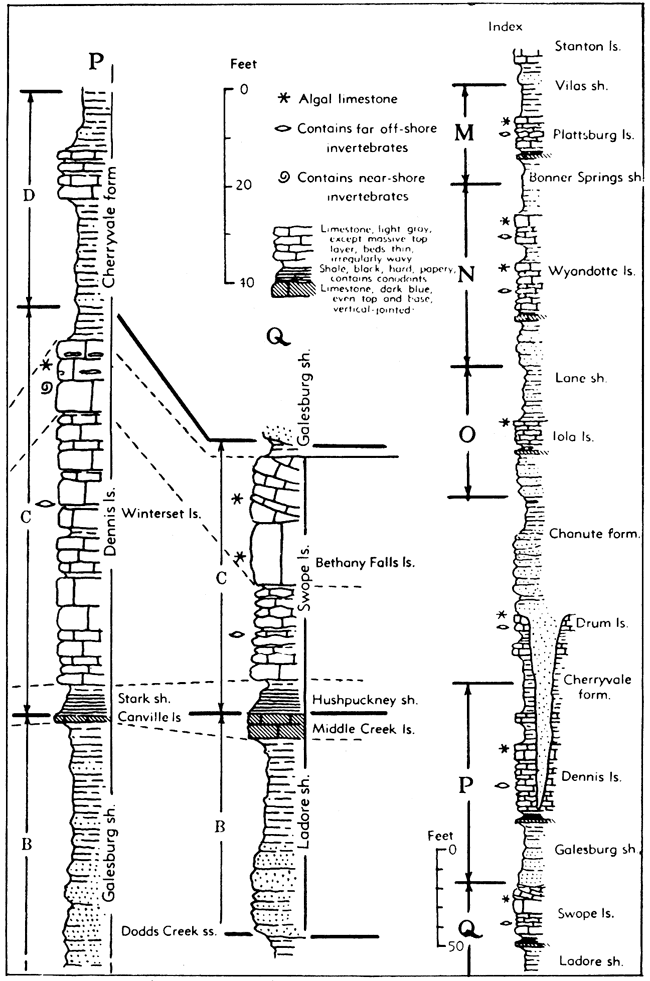
Dennis limestone--The uppermost formation of the Bronson subgroup contains two limestone members and a shale member. The capping limestone forms a long dip slope that terminates eastward at the prominent Bronson escarpment. In Oklahoma, this formation is known as the Hogshooter limestone. The thickness of the Dennis ranges from 2 feet in parts of Neosho County, where it is largely removed by pre-Chanute erosion, to 60 feet in northeastern Labette County.
Winterset limestone member--Light bluish-gray and light-gray limestone characterized by abundant flint. In the Kansas River area, the flint is almost black, but elsewhere it is light gray. Along much of the outcrop belt, cross-bedded oolite occurs in the upper part of the Winterset and there is much light-gray thin-bedded limestone having a brecciated appearance. Black platy shale containing land plant remains occurs in the middle part of the member in northern outcrops and calcareous gray shale occupies the same position in southern Kansas. Marine invertebrates are more or less abundant in various zones; in places there are well-preserved molluscan faunas. Locally in Neosho County, the Winterset limestone and possibly lower beds are cut out by the disconformity at the base of the Chanute shale. The thickness ranges from a featheredge to about 50 feet.
Stark shale member--Chiefly black shale but containing some gray and yellow shale in the upper part. The member is recognized only locally in Montgomery County and neighboring parts of Oklahoma but becomes persistent northward from northwestern Labette County. The normal thickness is about 3 feet.
Canville limestone member--Medium dark-gray dense to granular limestone, commonly massive but locally platy or slabby. This limestone is persistent from northwestern Labette County to Linn County. It is represented in parts of Montgomery County by about 1 foot of dark bluish-gray vertical-jointed limestone, and it reappears locally in Oklahoma. Thickness ranges from a featheredge to about 2 feet.
Galesburg shale--Gray and yellow marine shale, sandy nonmarine shale, sandstone, and a little coal. Probably some of the sandy shale and sandstone is marine. In the Kansas River Valley, the unit is about 3 feet thick and comprises calcareous nodular shale that is clearly distinguished by its light color and other lithologic features from the overlying black Stark shale. The thickness increases rather abruptly southward from Bourbon County and much sandstone is present in Neosho, Labette, and Montgomery Counties. Plant fossils are fairly common in the sandy facies. Southward from the point where the Swope limestone disappears, a few miles north of the Oklahoma line, the Galesburg is not separable as a unit and it forms the upper part of the Coffeyville formation. The thickness of the Galesburg shale ranges from 3 to 75 feet.
Dodds Creek sandstone member--Massive to thin-bedded sandstone, seemingly of deltaic origin, which occurs in the Galesburg shale in southern Kansas, is named the Dodds Creek sandstone member. The thickness of this subdivision is as much as 40 feet.
Swope limestone--Two limestone members and a shale member. The upper limestone is the most persistent, but it is not recognized southward from eastern Montgomery County (northern part of T. 34 S.). The thickness ranges from a featheredge to about 35 feet.
Bethany Falls limestone member--Light-gray, dense, thin-bedded limestone overlain by mottled gray, massive, algal limestone or by nearly white oolitic limestone that is commonly cross-bedded. Fossils are more or less common in the lower thin-bedded part. The thickness of the thin-bedded division ranges from 1 to 20 feet and that of the massive division from 7 to 15 feet. The total thickness ranges from about, 12 to 30 feet,
Hushpuckney shale member--Bluish-gray clay shale in the upper part, black fissile shale in the lower part. This unit and the underlying Middle Creek limestone are persistent northward from Neosho County. The thickness ranges from a featheredge to about 6 feet.
Middle Creek limestone member--Dark bluish-gray limestone, commonly dense and brittle, vertical-jointed. The maximum observed thickness is in southern Linn County where it is about 8 feet; the common thickness is about 2 feet.
Ladore shale--Gray and brownish-yellow shale, sandstone, and some coal. Like the Galesburg shale, the formation thickens southward. The Ladore is a thin marine shale in the Kansas City area and east-central Kansas, but it expands into a sandy deltaic deposit in southern Kansas. In Montgomery and southern Labette Counties, it is not easily separated from the overlying Galesburg shale and the two form the upper more sandy part of the Coffeyville formation. Thin coal beds are present in Labette county, and plant fossils are plentiful there. The thickness ranges from 2 to 50 feet.
Hertha limestone--Two limestone members and a shale member. The two limestones are persistent and distinct throughout much of the Kansas outcrop area, especially in Miami, Linn, and northern Bourbon Counties. In southern outcrops, the shale member is thin or absent. The formation is easily recognized northward from T. 33 S., Labette County, and can be identified in a thin zone as far southward as Coffeyville. The thickness ranges from a featheredge to about 30 feet.
Sniabar limestone member--Gray and brown limestone, ranging from more or less massive to thin-bedded. Marine fossils are moderately common and locally the coral "Aulopora" is abundant. The thickness ranges from a featheredge to about 10 feet.
Mound City shale member--Gray and yellow clayey to calcareous shale, containing a persistent 2-inch bed of crinoidal limestone in Linn and Bourbon counties. Marine fossils are locally plentiful. The thickness ranges from a featheredge to about 14 feet.
Critzer limestone member--Massive, brownish-gray, granular, partly algal limestone, and thin wavy-bedded gray limestone. In a part of the outcrop area this member is the most conspicuous part of the Hertha limestone, commonly forming a rimrock cliff along the Hertha escarpment. Much of the rock weathers deep brown. Bellerophontid gastropods are characteristic of the massive facies; brachiopods and corals are plentiful locally in the thin-bedded facies. The thickness ranges from a featheredge to about 11 feet.
Figure 33--Selected stratigraphic sections of Lansing and Kansas City rocks.
Pleasanton Group
Rocks lying between the base of the Hertha limestone and the disconformity that separates Missourian from Desmoinesian beds are mainly clastic sediments that mostly represent mechanically weathered detritus derived from land and deposited in shallow seas which advanced over Kansas after a time of more or less prolonged emergence. Gray, yellow, and dark-gray to black clay shale predominates, but there is much sandstone and some limestone and coal. The thickness ranges from about 70 feet to 130 feet.
Sandstone and interbedded black shale and flaggy limestone--In Linn and Miami Counties the upper part of this division is partly occupied by massive sandstone (Knobtown) which is locally as much as 25 feet thick. In southern Linn and northern Bourbon counties, thin beds of dense blue limestone alternating with thin beds of nearly black shale occupy the same position and attain a thickness of 45 feet. These deposits are absent for a short distance farther south, but black shale occurs in this position in Neosho and Labette counties. Near the point in Labette County where the Hertha limestone becomes very thin about 40 feet of black shale forms the top of the Pleasanton section. Average thickness of this division is about 30 feet.
Figure 34--Selected stratigraphic sections of Lansing, Kansas City, and Pleasanton rocks.
Light-colored Shale--Gray to yellowish shale that locally contains a few thin limestone beds comprises most of the middle and lower parts of the Pleasanton. This facies commonly extends downward to the Hepler sandstone. Fine-grained sandstone or siltstone forms the middle part of the Pleasanton in some places. In southern Bourbon and northern Labette Counties, light-colored shale extends to the base of the Hertha limestone. The thickness of this shale unit ranges from about 20 to 100 feet.
Checkerboard limestone--gray limestone, locally a coquina of gastropods or crinoid fragments; where more fully developed this formation comprises two thin limestones separated by dark shale. The Checkerboard limestone is an important marker in the Pennsylvanian strata of eastern Oklahoma and is recognized in southern Kansas as far north as T. 31 S. The thickness ranges from a featheredge to about 6 feet.
Hepler sandstone--Brown and gray sandstone named Hepler is a remarkably persistent sheetlike deposit overlying the regional disconformity at the base of the Missourian Series. A calcareous facies of the Hepler sandstone is seen locally in southern Kansas, but the unit and unconformable relationships cannot be identified in the subsurface a short distance west of the outcrops. The thickness ranges from about 2 to 20 feet.
The disconformity below the Hepler sandstone brings deposits classified as lowermost Missourian into contact with rocks ranging from the Memorial shale downward to the upper part of the Bandera shale. Paleontological evidence and indication of widespread interruption in sedimentation, accompanied by some erosion, support placement of the Desmoinesian-Missourian boundary at this position.
Figure 35--Sections of lower Lansing and upper Kansas City beds showing cyclothems grouped in megacyclothems. The individual cyclothems are indicated by the letters B, C, and D. Megacyclothems comprise the entire sequence of beds in any one the the three plotted sections M, N, O. Stratigraphic position of the sequences is shown on Figure 36. Algal-moluscan limestone beds are shaded.
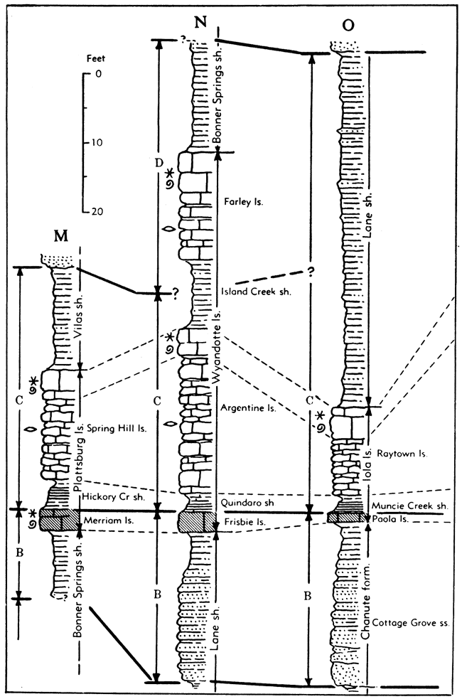
Figure 36--Sections of lower Kansas City beds showing cyclothems and megacyclothems. The individual cyclothems are indicated by the letters B, C, and D. Megacyclothems comprise the entire sequence of beds in any one the the three plotted sections P and Q. Algal-moluscan limestone beds are shaded.
Desmoinesian Series
The lowermost major division of the Pennsylvanian rocks at outcrops in Kansas is named the Desmoinesian Series. Named from exposures in central Iowa, it comprises the upper part of the Middle Pennsylvanian. The series occupies the stratigraphic interval between important regional disconformities. The Desmoinesian deposits are set off from the overlying Missourian rocks by pronounced paleontologic and lithologic differences.
Figure 37--Desmoinesian (Marmaton) rocks in Kansas. Read Amoret for "Tina."
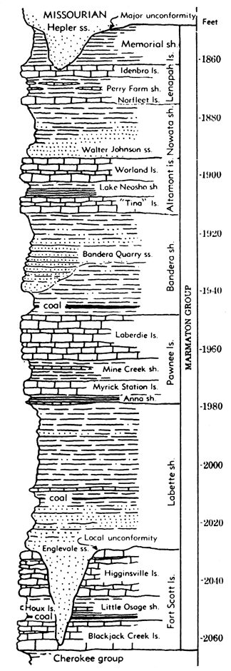
Marmaton Group
The upper part of the Desmoinesian beds in Kansas, approximately 250 feet thick, is assigned to the Marmaton group. These strata are more calcareous and more dominantly marine than those of the underlying Cherokee shale.
Memorial shale--Gray and yellowish clay shale, generally unfossiliferous. In Labette County it comprises dark-gray shale that bears marine fossils and contains two or more coal beds. The unit locally is absent owing to pre-Missourian erosion. The maximum known thickness is 30 feet.
Lenapah limestone--Two limestone members separated by a shale member. The formation is locally reduced in thickness or absent as a result of pre-Missourian erosion. The lower two members are absent in some places, owing to nondeposition. The Lenapah is well marked in southeastern Kansas but inconspicuous in east-central Kansas. Thickness ranges from 1 to 18 feet.
Idenbro limestone member--Chiefly light-gray crystalline and pseudobrecciated limestone; in Linn and Bourbon counties represented by brownish-gray to dark-gray limestone containing limonitic inclusions, mostly crystalline, but dense and earthy locally. This member forms low escarpments and broad dip slopes in the southern part of the outcrop area. The Idenbro limestone possibly is equivalent to rock called the Sni Mills limestone in Missouri. Characteristic thickness in the northern part is 1 to 2 feet; in the southern part it is 6 to 9 feet.
Perry Farm shale member--Light- to dark-gray clay shale containing nodules of limestone; grades laterally into nodular limestone south of the Kansas-Oklahoma line. The shale is abundantly fossiliferous locally, brachiopods occurring in the upper part and a molluscan fauna in the middle and lower parts. The member is locally absent in the northern part of the outcrop area. The thickness ranges from a featheredge to about 20 feet.
Norfleet limestone member--Dark brownish-gray massive to bluish-gray slabby limestone. The Norfleet resembles local facies of the Idenbro limestone in some northern outcrops. South of the Kansas-Oklahoma line, this member grades into massive dense limestone that is continuous with overlying nodular limestone facies of the Perry Farm shale, but distinction of the two members is clear. The thickness ranges from a few inches to about 3 feet.
Nowata shale--Gray to yellow clay shale, sandy shale, and sandstone: marine and nonmarine. The formation is locally absent in Linn County and in the subsurface of Miami County, owing to pre-Missourian erosion. Measured thickness in Kansas, 3 to 30 feet.
Walter Johnson sandstone member--Thin-bedded to massive sandstone in the lower and middle Nowata shale, observed in parts of southern Kansas, has been named the Walter Johnson sandstone. It is equivalent to the "Wayside sand" of the subsurface. Outcrop thicknesses are commonly 4 to 10 feet.
Altamont limestone--Two limestone members separated by a shale member. The lower limestone is most prominent in the southern part of the outcrop area, and the upper limestone is most prominent in northern outcrops. The formation is locally absent in the subsurface of Miami County owing to pre-Missourian erosion. The thickness is about 6 to 25 feet.
Worland limestone member--Light-gray limestone, dense, semilithographic in upper part, remainder mostly crystalline, pseudobrecciated and wavy-bedded. Marine fossils characteristically are few but there are prominent brachiopods and fusulines, the latter locally abundant. Thickness commonly about 8 feet.
Lake Neosho shale member--Light- and dark-gray and nearly black shale; generally black in middle part, locally all dark; containing abundant phosphatic concretions. The thickness ranges from about 2 to 8 feet.
Amoret limestone member--Light-gray, massive, coralline (Chaetetes) and dense limestone, associated with two shale beds in the southern part of the outcrop area. The limestone is darker, more granular and locally cross-bedded in the northern part. The thickness is 1 foot or less to 2 feet in the northern part, about 10 feet in the southern part.
Bandera shale--Mainly nonmarine gray, yellow, and maroon clay shale, mostly blocky, well-bedded; massive to thin-bedded sandstone; and the Mulberry coal bed near the base. Maroon bands occur in the upper part. The formation contains limonitic concretions and veins and locally septarian limestone concretions. Plant fossils are found in the sandy facies, generally in the lower part. The Mulberry coal is a persistent bed in the lower part of the Bandera north of Crawford County. Shale below the coal is is light to dark gray and carbonaceous. Locally, a thin dark-gray limestone lies closely above the Mulberry coal. The thickness ranges from about 20 to 50 feet.
Bandera Quarry sandstone member--Gray and brown sandstone, generally thin-bedded, locally "flagstones," lenticular. The thickness ranges from a featheredge to 30 feet or more.
Pawnee limestone--The upper main part of the Pawnee formation comprises two persistent limestone members separated by a shale member; the lower part consists of shale and a thin nonpersistent basal limestone. Thickness ranges from about 15 to 60 feet.
Laberdie limestone member--Light-gray crystalline, and coralline (Chaetetes) limestone in thin wavy to massive beds that form extensive dip slopes and cap prominent escarpments. Fusulines and other marine fossils are locally plentiful. Field studies in Missouri not yet published, are reported to indicate equivalence of the Laberdie limestone to the unit called Coal City limestone in northern Missouri and Iowa. The thickness is about 10 to 20 feet.
Mine Creek shale member--Light- and dark-gray to black shale, flaky, platy and fissile, containing one or more thin limestone beds in the middle part locally. Generally brachiopods are abundant, corals fewer. This member is reduced to very slight thickness or is absent in the southern part of the outcrop area. The thickness ranges from a featheredge to 15 feet.
Myrick Station limestone member--Dark-gray, brown, and light-gray limestone. The lower part, comprising about 2 feet of massive dark-gray brown-weathering limestone, is most persistent, and this is overlain locally by lighter-colored coralline (Chaetetes) limestone. The thickness ranges from 2 to about 8.5 feet.
Anna shale member--Black, platy, locally fissile shale, containing a few inches of gray shale near the top in some places; small smooth phosphatic concretions are common. A thin bed or lenses of dark, slabby, crystalline, locally crinoidal limestone occur in the basal part. Thickness commonly ranges from 2 to 5 feet.
Labette shale--Gray and yellow clay shale, sandy shale, sandstone, and thin coal and limestone beds; a rather persistent black shale and a bed of coal occur in the basal part. Black shale occurs locally in the upper part. Some sections show several thin limestone and coal beds. A persistent limestone, 1 to 2 feet thick, occurs in the middle lower part. Thickness ranges from about 30 to 100 feet.
Englevale sandstone member--This is one of several bodies of sandstone, collectively referred to as Warrensburg sandstone, lying in the middle and lower parts of the Labette shale. This is the "Peru sand" of the subsurface. Average thickness, about 30 feet.
Fort Scott limestone--Comprises two limestones and an intervening shale member, the latter containing a persistent coal and a limestone bed in the northern part of the outcrop area. Characteristic thickness is about 33 feet.
Higginsville limestone member--Chiefly light-gray thin-bedded to massive limestone characterized by the scattered occurrence of unusually large crinoid stems, irregular distribution of minute, medium, and large fusulines, and colonies of Chaetetes that generally are isolated but locally form the entire upper part. Characteristic thickness is about 15 feet.Little Osage shale member--Black platy shale containing small smooth phosphatic concretions, and gray clayey calcareous shale, coal, and limestone. Upper part generally light gray and calcareous, lower part commonly black and platy. The Houx limestone is a persistent thin bed of granular limestone that occurs a few inches to 2 or more feet below the Higginsville limestone. The Summit coal, which is persistent from northern Crawford County northeastward into Missouri, occurs in the upper middle part of the Little Osage shale. Thickness of the member ranges from about 4 to 12 feet.
Blackjack Creek limestone member--Brownish-gray, granular, and massive to light-gray, crystalline, pseudobrecciated, thinner bedded, and locally Chaetetes-bearing. The lower part, the only persistent part of the member, is approximately 2 feet thick and consists of brownish-gray brown-weathering "cement rock." Thickness ranges from about 4 to 17.5 feet.
Cherokee Group
Pennsylvanian rocks below the Fort Scott limestone in Kansas, which consist mainly of clastic rocks with light- and dark-colored shale predominating, are now classified as a group. There is much sandstone and sandy shale, and the most important coal beds of the State are in the Cherokee. The amount of limestone is small. The group is not readily divisible into mappable units, and until work now in progress is completed, the rocks are described on the basis of cyclic deposition. Parts thus differentiated are not treated as formations but are called cyclothems (deposits of a cycle). Some differences from previous publications are introduced in this report on the basis of studies by W. B. Howe, of the Kansas Geological Survey. The thickness at the outcrop ranges from about 400 to 550 feet.
Figure 38--Desmoinesian (Cherokee) rocks in Kansas.
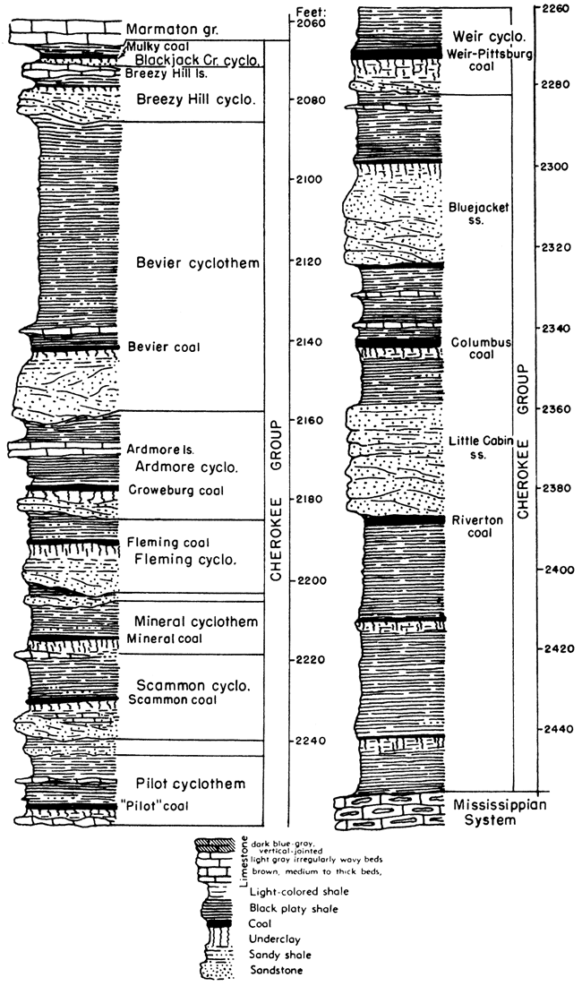
Blackjack Creek cyclothem--Sandy shale, underclay, coal (Mulky bed), black shale, and limestone (Blackjack Creek limestone) belonging in the lower part of the Fort Scott limestone comprise a widely distributed cyclic sequence which may be termed the Blackjack Creek cyclothem. Average thickness is about 15 feet.
Breezy Hill cyclothem--In the northeastern part of the outcrop area, the Breezy Hill cyclothem consists of a thin impure limestone of irregular thickness (Breezy Hill limestone) and a thin-bedded fine-grained sandstone ("Squirrel" of the subsurface). To the southwest, in Labette County, Kansas, and Craig County, Oklahoma, an underclay, coal, and calcareous shale sequence separates the Breezy Hill limestone and "Squirrel" sandstone. Thickness ranges from 10 to 15 feet.
Bevier cyclothem--Beds assigned to this cyclothem include strata below the "Squirrel" sandstone and above the Ardmore limestone in the northern and eastern parts of the outcrop area in Kansas. In the southwestern part, the unconformity at the base of this cycle occurs 12 to 15 feet above the Ardmore limestone. Where fully developed, this cycle includes: a basal sandstone, underclay, coal (Bevier), dark impure limestone, and an upper gray shale, the latter ranging in thickness from 40 to 80 feet. Thickness of the entire cyclothem ranges from 45 to 85 feet. The "Stice" coal of some reports is the same as the Bevier coal of Crawford and Cherokee Counties, Kansas.
Ardmore cyclothem--The Ardmore limestone and Croweburg coal (Broken Arrow of Oklahoma) are persistent units in the Ardmore cyclothem. Where fully developed, this cyclothem includes, in ascending order: "fresh-water" limestone or sandstone, underclay, coal (Croweburg), gray shale, black slaty shale, massive limestone (Ardmore), and gray shale, calcareous in the basal part. Thickness ranges from 20 to 35 feet. Further work may establish assignment of the Ardmore limestone with associated black shale and the Croweburg coal to separate cyclothems. In such event, the Croweburg coal, overlying gray shale, and underlying underclay and sandstone or fresh-water limestone may constitute a distinct cyclic unit.
Fleming cyclothem--Strata included in this cyclothem include, in ascending order: sandstone, underclay, coal (Fleming), dark-gray to black shale, calcareous in lower part. The Fleming coal is characterized by its irregular thickness. Thickness of this cyclothem ranges from 15 to 20 feet.
Unnamed cyclothem--Field work now in progress indicates the local existence of a cyclothem in this position. At present it is recognized only in western Cherokee County, where a nearly fully developed cycle exists.
Mineral cyclothem--This cyclic unit consists of underclay, coal (Mineral), black shale, and gray shale. The black shale is calcareous, and abundantly fossiliferous, especially where thin beds of black limestone occur in the shale. The thickness of the cyclothem is about 12 feet.
Scammon cyclothem--This cyclothem is rarely exposed, because the Scammon coal is not now minable, and present strip-mining operations rarely intercept it. It includes in ascending order: sandstone or impure limestone, underclay, coal (Scammon), black shale, commonly calcareous and fossiliferous, and gray shale. Thickness ranges from 20 to 30 feet.
Unnamed cyclothem--Field investigations of the Kansas and Missouri Geological Surveys indicate the presence of a cyclothem between the Scammon and Pilot cyclic units. Only partial development of this cyclothem is known to exist in Kansas, however.
Pilot cyclothem--Strata of this cyclothem include, in ascending order: "fresh-water" limestone, underclay, coal (Pilot), black shale, dark pyritic limestone, and dark-gray shale. Thickness of this cyclothem ranges from 15 to 20 feet.
Weir cyclothem--This unit includes the most important coal deposit of Kansas. It contains an unusually thick underclay and a basal sandstone. Over much of the outcrop area, the coal (Weir-Pittsburg) is characterized by a parting in the lower part. Thickness of the coal averages about 3 feet, and the total thickness of the cyclothem is about 30 feet.
Lower Cherokee cyclothems--Present knowledge of lower Cherokee strata does not allow reliable division of them into cyclic units. Only broad features may be noted. The thickness of deposits between the Weir Pittsburg coal and Mississippian limestones ranges from 200 to 250 feet in Cherokee and Crawford counties. The basal part of the Cherokee group at outcrops in southeastern Kansas is commonly black shale. Several persistent coals occur in this part of the section, including, in descending order, Knifeton, Rowe (Columbus), and Riverton. Two important sandstones, Bluejacket and Little Cabin, also occur in this section. The Little Cabin sandstone is correlated with the Warner sandstone of Oklahoma. In some reports, five cyclothems have been named and described as occurring in the Cherokee section below the Weir cyclothem, but these are not now judged to be established reliably. Nevertheless, sequences of sandstone, underclay, coal, black shale, and gray shale in the lower part of the Cherokee are similar to the cyclical arrangement of higher beds of the group,
Figure 39--Selected stratigraphic sections of Kansas City, Pleasanton, and Marmaton rocks.
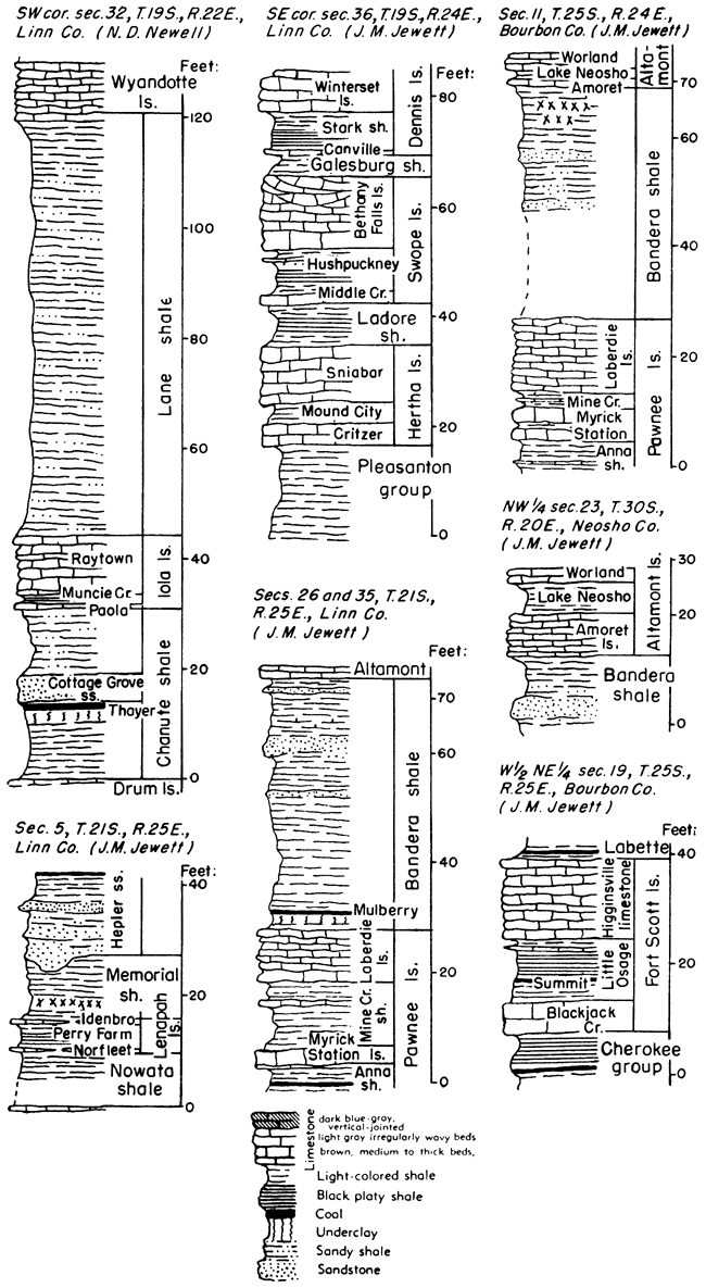
Atokan Series
Rocks ranging in thickness from a featheredge to about 500 feet and encountered at a depth of about 4,500 feet in southwestern Kansas are assigned to the Atokan Series. These rocks comprise chiefly limestone and shaly limestone. The Atokan deposits are separated from overlying Desmoinesian rocks and from underlying Morrowan deposits by unconformities.
Figure 40--Selected stratigraphic sections of Kansas City, Pleasanton, and Marmaton rocks.
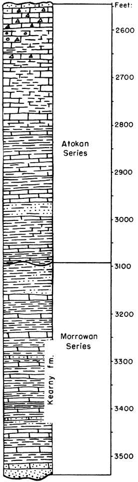
Morrowan Series
In Kansas rocks of Morrowan age are known only in the southwestern part of the State, at a depth of about 5,500 feet. These rocks, in part classified as the Kearny formation, comprise shale, limestone, and sandstone. The maximum thickness in Kansas is about 350 feet.
Figure 41--Selected stratigraphic sections of Kansas City, Pleasanton, and Marmaton rocks.
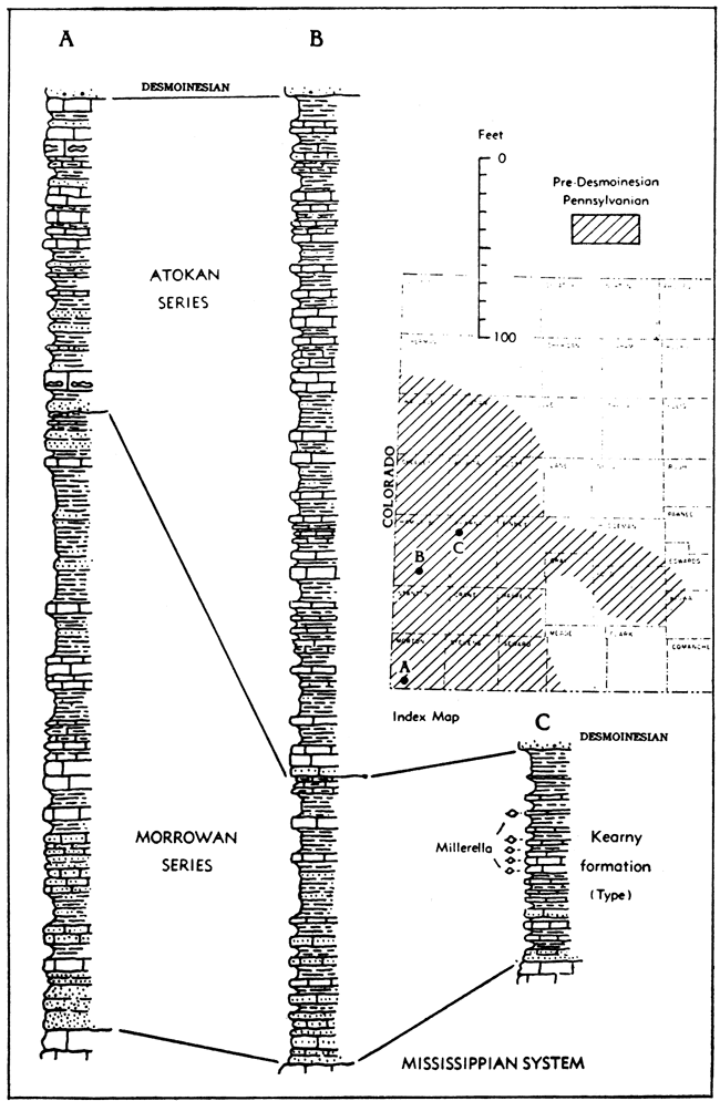
Prev Page--Igneous and Metamorphic || Next Page--Pre-Pennsylvanian
Kansas Geological Survey, Geology
Placed on web Oct. 28, 2008; originally published Jan. 1951.
Comments to webadmin@kgs.ku.edu
The URL for this page is http://www.kgs.ku.edu/Publications/Bulletins/89/06_pale.html