![]()
Prev Page--Stratigraphy--Silurian || Next Page--Stratigraphy--Mississippian
Stratigraphy, continued
Rocks of Devonian Age
General Description
Devonian rocks crop out in eastern Iowa, central and eastern Missouri, parts of northern Arkansas, and southeastern Oklahoma. The upper or Devonian part of the Hunton limestone of the outcrops in southern Oklahoma consists of the Bois d'Arc limestone above and the Haragan shale below. The Haragan shale, as described by C. A. Reeds (1911), consists of alternating blue resembles the Henryhouse shale of Silurian age, but Ireland (1936, p. 1098) was able to distinguish the Haragan by the absence of foraminifera of the type common in the Henryhouse. He concluded for this reason that the Haragan is absent in northern Oklahoma. The Haragan is of Lower Devonian (Helderbergian) age. It has been correlated by Ireland (1936, p. 1095) and others with the Bailey limestone of southeastern Missouri (also of Helderbergian age).
The Bois d'Arc limestone, the youngest Devonian in southern Oklahoma, is described by Ireland as a white dense cherty limestone with insoluble residues of white dense chert and small amounts of sand grains. The beveled edge of the Bois d'Arc is overlain in most wells in northern Oklahoma by Mississippian rocks, and it is even more restricted in its subsurface distribution than the Haragan shale. The Bois d'Arc is of Lower Devonian (Oriskany and Becraft?) age, and is a partial equivalent of the Little Saline limestone of southeastern Missouri.
The Devonian outcrops nearest to northeastern Kansas are in north-central Missouri on the eastern border of the Forest City basin. E. B. Branson (1923, pp. 19-47; 1941) distinguishes in the outcrops the following Devonian formations, in ascending order: Cooper limestone, Ashland limestone, Callaway limestone, and Snyder Creek shale.
The Cooper limestone at the outcrops in north-central Missouri is composed chiefly of dark to bluish-gray dense lithographic limestone which is very sparingly fossiliferous. It is flecked with crystals of calcite and includes sparsely disseminated rounded and frosted grains of sand. A bed of sandstone, calcareous sandstone, or sandy limestone of variable thickness and character almost invariably occurs at the base of the formation; this provides and important datum bed for determining the base of the Devonian in the subsurface. The thickness of the Cooper at the type locality in Cooper county, Missouri, is 30 feet. The few fossils obtained from the formation do not determine its age very definitely. Its correlative farther east in northeastern Missouri, the Mineola limestone, is more varied in lithology and contains crinoidal and fossiliferous limestones by means of which it has been correlated' by Branson with the Grand Tower limestone of southeastern Missouri and with some part of the Wapsipinicon of southeastern Iowa. On account of the stratigraphic relations of the Cooper to the Mineola, the Cooper is also correlated with the Grand Tower of Middle Devonian (Onondaga) age.
The Ashland limestone was described by Branson (1941, p. 83) as a formation because of its "distinct lithology, unique fossils, and its relationship to adjoining formations." The name Ashland has, however, already been preempted for a Silurian limestone in Maine., The Ashland of Missouri is described by Branson as composed of limestone, crowded with fossils, but it is so dense that few good specimens have been recovered. It occurs in small areas of only a few acres extent between Jefferson City and Hannibal, Missouri, and has a maximum observed thickness of only 15 feet. The Ashland is reported to be unconformable below the Callaway and unconformable above the pre-Devonian rocks. The Ashland is believed by Branson to occur stratigraphically between the Cooper and Callaway, but it is not known to be anywhere in contact with either the Cooper or the Mineola.
At surface outcrops the Callaway formation is also a fine-textured limestone but it is more fossiliferous than the Cooper limestone and contains some beds of semigranular limestone. Lithologically, it resembles the Mineola, but Branson differentiates them by paleontologic criteria. The Callaway, like the Mineola, has a basal sandy zone, but sandy limestones crop out higher in the formation also. The Callaway is "roughly correlated" by Branson with the Cedar Valley limestone of southeastern Iowa and with the St. Laurent limestone at the top of the Devonian section in southeastern Missouri, which is of Middle Devonian (Hamilton) age.
The Snyder Creek shale, which in some localities in northcentral Missouri overlies the Callaway limestone, consists of thin impure and nodular limestones interbedded with shale, sandy shale, and thin beds of silt and fine sandstone. Branson correlates the Snyder Creek shale with the Tully or Genesee (Upper Devonian) of New York. Stainbrook (1935, p. 260) suggests its correlation with the upper part of the Cedar Valley of Iowa. It appears, therefore, that the Devonian rocks of this part of Kansas are not older than Middle Devonian. The Devonian beds included in the Hunton of northeastern Kansas are, therefore, younger than the Devonian beds (Lower Devonian) of the Hunton in Oklahoma, a fact Well illustrating the varied age of the rocks included under the term Hunton. The following table shows the correlation of the Devonian in northeastern Kansas with the Devonian of Oklahoma and northern Missouri.
Table 2--Correlation of Devonian, formations.
| Northern Missouri E. B. Branson (1923 and 1941) |
Southeastern Oklahoma C. A. Reeds (1911) |
Northeastern Kansas | |
|---|---|---|---|
| Upper Devonian | Snyder Creek shale | Undifferentiated limestone and dolomite |
|
| Middle Devonian | Callaway limestone | ||
| Ashland limestone | |||
| Cooper limestone | Cooper limestone | ||
| Lithographic limestone | |||
| Sandy limestone or calcareous sandstone |
|||
| Lower Devonian | Bois d'Arc limestone | ||
| Haragan shale |
Middle Devonian Limestones of Cooper and Younger Age
Rocks lithologically similar to the Cooper limestone of central Missouri have been traced by means of well cuttings into northeastern Kansas where, as in Missouri, a much greater thickness of Devonian rocks occurs in the subsurface toward the north than toward the south. The Devonian as well as the Silurian rocks are characterized by relatively small amounts of insoluble residues when compared with the Mississippian limestones above and the Kimmswick and earlier limestones below. In general, however, the Devonian is slightly more siliceous than the Silurian, for although a large part of the Devonian is very pure limestone or dolomite some zones are highly siliceous. Traces of anhydrite have been observed in the insoluble residues from samples of the basal Devonian deposits and occur sporadically in younger Devonian rocks, but no well-defined zone of anhydrite deposition has been identified.
In the outcrops of central and northeastern Missouri, the Devonian is less than 100 feet thick and consists entirely of limestone, much of which is lithographic. The limestone phase of the Devonian prevails at the surface and westward in the subsurface in a belt flanking the Ozark region. In Clay and Platte counties, Missouri, near the Kansas line, about 200 feet of Devonian rocks is present, all of which is limestone. North of this area and of the area of outcrop in Missouri, the limestone is interstratified with bands of dolomite that are vaguely traceable from well to well and become thicker until they merge into a continuous section of dolomite more than 400 feet thick in the deeper parts of the North Kansas basin. Similar stratigraphic changes occur in Kansas except that the transition from limestone to dolomite toward the north and west is more abrupt than in Missouri.
Outcrops of the Devonian formation in northern Missouri and Iowa were visited by the writer accompanied by R. C. Moore and H. G. Hershey. More than 100 samples of Devonian rocks were collected. These samples and others from southeastern Missouri and their insoluble residues were studied in an attempt to correlate the surface rocks with samples of the subsurface rocks secured from wells.
The various formations into which Branson has divided the Devonian of northern Missouri, with the exception of the Cooper, have not been recognized as lithologic units in the subsurface of northeastern Kansas. The Snyder Creek shale was reported by McQueen in the subsurface in northwestern Missouri, but it has not been identified in northeastern Kansas. Although the subdivisions of the Devonian at the surface, other than the Cooper, have not been identified in wells in northeastern Kansas, some datum zones have been recognized by means of insoluble residues and microscopic study of samples.
The Cooper limestone is identified in the subsurface by its characteristic lithographic texture, its disseminated sand grains, and particularly by the sandy limestone member which is easily recognized in most wells at its base. The Cooper in its typical character has been traced by well cuttings from the outcrops into Clay and Platte counties in west-central Missouri and into adjoining areas in Kansas, but, although the base is well marked, its upper limit is indeterminable by lithology in the subsurface as well as in the outcrops.
The lithographic limestone phase of the Cooper predominates as far west as central Douglas County and as far north as southern Jefferson County. The Cooper limestone becomes dolomitic west and north of these limits and loses its typical lithology, although most of the dolomite, like the lithographic limestone, is densely crystalline. The Devonian dolomite which corresponds to the lithographic limestone is generally more sucrose and more dense than the Silurian dolomite which is composed largely of coarsely crystalline dolomites with many vugs lined with sparkling crystals of dolomite of the same grain as the rock. The change in texture provides a satisfactory point of separation where the Devonian and Silurian are thin, but the upper part of thick sections of the Silurian in some wells consists of alternating zones of dense and coarsely crystalline dolomite so that the contact cannot be determined on this basis alone.
The amount of sand in the basal beds of lithographic limestone and the corresponding dolomite is extremely variable. In some wells, such as the Landsprecht et al. No. 1 Griffin, in sec. 4, T. 14 S., R. 18 E., and the Ramsey Petroleum Company No. 1 Kaul, in sec. 2, T. 11 S., R. 11 E., the basal sand bed has so little cementing material that cuttings from the underlying rocks are contaminated by cavings. In other wells the sand is sparingly disseminated in limestone or dolomite and is revealed only by insoluble residues, although sand grains enclosed in limestone or dolomite are occasionally seen. The sandy character of the basal beds gradually fades out toward the west and north, and the base of the Devonian in those areas is difficult to determine and can be established only by other criteria. The amount of sand in the basal beds diminishes roughly in proportion to the distance from the pre-Devonian outcrops of St. Peter sandstone, from which it is presumed to have been derived, but the topography of the preDevonian surface may also have influenced the amount of sand deposited locally. Thus the basal lithographic Cooper limestone shows only small traces of disseminated sand in the McCain No. 1 Doane well, in sec. 34, T. 12 S., R. 22 E., and in the Dunn No. 1 Morgan well, in sec. 6, T. 13 S., R. 22 E., but the basal Cooper yielded over 50 percent sand in the Roxane No. 1 Fisher well in sec. 19, T. 11 S., R. 22 E., and the Ryan Consolidated No. 1 Laming well, in sec. 22, T. 11 S., R. 21 E., 6 miles farther from the preDevonian St. Peter outcrop.
The amount of sand, although irregularly distributed, decreases toward the north and west so that in parts of southeastern Nebraska and in Wabaunsee and Riley counties, Kansas, no sand is recovered in the residues except such as might be introduced by contamination from higher formations.
The quartzose chert zone is characterized by cryptocrystalline quartz, but it is quite varied in character and locally includes other types of siliceous residues. In samples from most localities the insoluble residue consists of gray to brown semiopaque rough cryptocrystalline chert. In some places this chert appears to be a final stage of quartz replacement, for residues grade from hackly quartz at the top of the zone to quartzose chert at the base. In some places the chert is associated in the residues with spongy dolocastic siltlike chert. The quartz content of the rocks is generally not apparent in the samples but is revealed in the insoluble residues. In counties around Kansas City in both Missouri and Kansas much smoothly fractured semiopaque gray chert occurs in this zone. Some of this chert is very dark and some is black. The quartzose chert zone is 5 to 30 feet thick and is 5 to 70 feet above the base of the Devonian. The amount of chert in this zone, as indicated by the insoluble residues, constitutes 5 to 65 percent by volume of the sample. The actual quantity of chert in the rocks, however, is probably not so great because of the partial loss of calcareous components in wells drilled by standard tools.
The quartzose chert zone has not been reported in the outcrops of central Missouri, so its relation to the Cooper and Callaway formations is uncertain. It may be that this zone contains relatively little chert in the areas of outcrop of the Cooper and Mineola and has thus escaped observation. This zone has been noted in wells in northwestern Missouri, where thicker sections of the Devonian occur than in the outcrops. The quartzose chert zone occurs with varying characteristics in nearly all wells in northeastern Kansas.
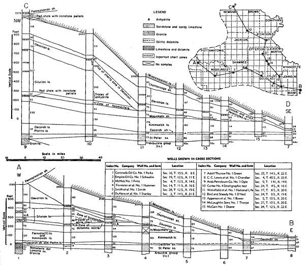
The interval between the top of the quartzose zone and the base of the Devonian increases irregularly down dip toward the center of the North Kansas basin. In wells in Johnson County, near the margin of the basin, the black and dark chert of this zone forms a part of the basal deposit. In Platte County, Missouri, the black chert which is a part of the quartzose chert zone is 25 feet above the base of the Devonian. In northern Buchanan County, Missouri, the black chert is 60 feet above the base. In Kansas a similar increase of this interval occurs, but the black chert is generally not present. The relations are interpreted as indicating more or less complete peneplanation of the pre-Devonian surface with differential subsidence of the peneplaned surface in the North Kansas basin during early Devonian deposition. Thus, the earliest Devonian deposit, the sandy zone, was laid down as a basal deposit transgressing toward the southeast (see fig. 7) with the quartzose chert zone converging on the sandy zone as the latter overlapped upon the sloping surface.
The quartzose zone is so widely distributed that it furnishes an approximate datum bed for determining the base of the Devonian when the basal sandy member is absent. Thus in the Coronado Oil Company No. 1 Parks well, in sec. 16, T. 10 S., R. 8 E., Riley County, a quartzose chert zone, with residues of dolocastic almost silt-like quartz sponge grading downward into quartzose chert, was reached at a depth of 1,480 feet. No sandy zone indicates the base of the Devonian in this well, but a change in the character of the dolomite from dense crystalline dolomite to porous sucrose dolomite with coarse vugs at 60 feet below the top of the quartzose zone is believed to indicate the base of the Devonian. The samples from the upper part of the Devonian in this well are contaminated by cavings of shale from the Pennsylvanian basal conglomerate. The sand in the insoluble residues is believed to have come from the same source and thus is not indicative of the base of the Devonian.
Neither the quartzose chert zone nor the basal sandy zone was satisfactorily identified in the Turner et al. No. 1 Umschied well, in sec. 32, T. 8 S., R. 9 E., Pottawatomie County. In this well there are several alternations from sucrose to dense crystalline dolomite above the foraminiferal zone of the Silurian so that the base of the Devonian remains in doubt. Sand is present in the residues to a depth of 1,385 feet, but it is associated with sandy clay which might have been derived from the Pennsylvanian basal conglomerate. No sand was found enclosed in the dolomite so for this reason, too, the evidence of sand in the residues is discounted.
Other lithologic zones yielding insoluble residues of porous and spongy quartz, hackly quartz, and various types of semiopaque chert and chalcedony have been observed, but it has not been possible to trace them from well to well. Traces of anhydrite and sphalerite have been noted in samples roughly 200 feet above the base of the Devonian. The erratic discontinuity of these zones of insoluble residues leads to speculation that one or several obscure unconformities may be present within the 300 or 400 feet of Devonian rocks represented in the subsurface of this area.
A well-defined zone, about 30 feet thick and about 300 feet above the base of the Devonian, was traced across northern Missouri in wells in the deeper parts of the basin near the Iowa border where the Devonian rocks are thick. This zone is characterized by insoluble residues of fine quartz crystals partially filling the cavities of what were probably incompletely preserved bryozoans. The crystals do not have a common orientation nor were they deposited in crusts or in drusy masses; they occur irregularly linked and partially joined together in loose visceralike assemblages. This "bryozoan quartz" is accompanied by other siliceous residues, some of which are persistent and others are of only local development. Among the more common types is a dense gray finely microfossiliferous and spicular chert which is found in small amounts. A limestone outcrop of similar microfossiliferous chert was seen near the top of the Devonian outcrops in Rails County, Missouri, but the position of the outcrop in the Devonian section there could not be determined. Microscopic flattened exfoliating cabbage-shaped pellets of blue-gray opaque chalcedony of possible foraminiferal origin occur also in the residues of some zones. None of the wells in northeastern Kansas encountered Devonian sections thick enough to include the zones containing these siliceous residues.
The thickness of the Devonian in Kansas is variable. It decreases toward the southeast and increases toward the North Kansas basin until it attains a thickness of at least 250 feet in Kansas. It is even thicker in southeastern Nebraska and extreme northwestern Missouri.
The Devonian rocks are separated from the overlying and underlying rocks by important angular unconformities. The Devonian rocks in the area of outcrop in northern Missouri were deposited unconformably upon Ordovician rocks. In parts of Franklin County, Kansas, the Devonian overlies the St. Peter sandstone and toward the northwest progressively transgresses rocks of Kimmswick, Maquoketa, and Silurian age (fig. 7).
The relations shown in figure 7 indicate that prior to the deposition of the Devonian in northeastern Kansas there was regional subsidence toward the northwest in east-central Nebraska and elevation toward the southeast where the Ozark area was rising. These tilted rocks were deeply eroded and beveled to a relatively perfect plain. The Devonian rocks were thus deposited across the beveled edges of the earlier rocks and probably extended originally toward the southeast far beyond the limits of their present distribution, perhaps covering part of the Ozark region.
Figure 7--Cross sections showing unconformities at the base of the Devonian limestone and at the base of the Chattanooga shale, on lines A-B and C-D of inset map. The cross sections are correlated on the top of the St. Peter sandstone. The relations shown at the top of the Silurian were produced by a regional tilting toward the northwest after Silurian deposition and by subsequent erosional beveling. The Devonian rocks were deposited upon this surface. The region was again tilted in the same direction after Devonian time and again peneplaned. This was followed by deposition of Chattanooga shale.
Figures at left of wells at top show depth in feet below the surface. Figures at right of well show thickness in feet of lithologic units. A larger version of this figure is available as an Acrobat PDF file (608 KB).
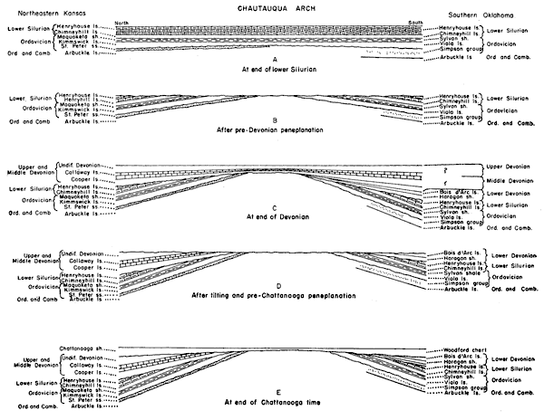
The widespread distribution of the quartzose zone near the base of the Devonian and the convergence of this zone with the basal sandstone toward the rising area to the southeast suggests that there had been renewed subsidence in the North Kansas basin just before or during Devonian submergence. It is probable that the center of this basin was sinking faster than the margin and that other units of the Devonian are thicker in the center of the basin than on the margin. It is also probable that younger deposits of considerable thickness overlapped the marginal land toward the Ozarks but that these overlapping Devonian beds which are still preserved in the basin were removed from the margin during the pre-Chattanooga upheaval and peneplanation. It is believed, therefore, that most of the increased Devonian section of the subsurface is younger than the outcrops in central Missouri. Inasmuch as the Cooper has been correlated with some part of the Grand Tower limestone, it is inferred on purely stratigraphic grounds that most of the Devonian of the subsurface is of Grand Tower age or younger. The Devonian rocks in the subsurface of northeastern Kansas are, therefore, chiefly of Middle but perhaps in part of Upper Devonian age. One of several possible relations of the deposits north and south of the Chautauqua arch is shown in figure 8.
Figure 8--Diagrammatic cross section showing evolution of Chautauqua arch and the relation of Lower Devonian rocks in southern Oklahoma and adjacent areas to Middle Devonian rocks of northeastern Kansas and adjacent areas. A larger version of this figure is available as an Acrobat PDF file (344 KB).
Cross section A represents initial movements of Chautauqua arch between end of St. Peter time and end of Maquoketa time (see fig. 11). Cross section B represents pre-Devonian peneplanation of deformed Silurian and older rocks. Cross section C represents deformation during deposition of Devonian rocks. The earliest Devonian rocks of Oklahoma are older than those in northeastern Kansas. Cross section D represents increased deformation of the Chautauqua arch, tilting of the region toward the north, and pre-Chattanooga peneplanation. Cross section E represents renewed movement on Chautauqua arch before or during deposition of Chattanooga shale and shows the relations of older rocks to the Chautauqua arch at the end of Chattanooga deposition. The relation of the St. Peter sandstone on the north side of the Chautauqua arch to the Simpson group on the south side of the arch is uncertain. The former occurrence of Upper and Middle Devonian rocks in Oklahoma is assumed. The occurrence of a correlative of the Henryhouse limestone in the deeper parts of the North Kansas basin has not yet been proved.
An unconformity separates the Devonian limestone from the overlying Chattanooga shale. At the end of deposition of the Devonian limestone and dolomite the region was again deformed along the same lines as those which preceded the deposition of the Devonian, that is flexing on the axis of the Chautauqua arch. The North Kansas basin again subsided and erosion proceeded to peneplanation, leaving the wedge-shaped edge of the Devonian rocks extending beyond and concealing the previously base-leveled surface of the Silurian rocks, the Maquoketa shale, the Kimmswick formation, in some places the St. Peter sandstone, and locally even the upper formations of the Arbuckle. The Chattanooga shale was deposited upon this peneplaned surface.
The Devonian rocks are a prolific source of oil in parts of central and western Kansas. Most of the oil produced in the southeastern Nebraska pools is from porous Devonian rocks. Many of the dry holes drilled into the Devonian in northeastern Kansas have revealed oil stains and shows of oil in the limestones and dolomites of the upper part of the Devonian, but the Devonian rocks encountered to date in northeastern Kansas have been uniformly dense and lack the porosity necessary to provide a reservoir for oil.
Because of the beveling of the Devonian rocks prior to Chattanooga time different parts of the Devonian sequence were exposed to weathering in different places (fig. 7). The lowest and oldest beds of the Devonian were exposed toward the southeast and progressively younger Devonian rocks were at the surface toward the northwest. The exposed edges were ultimately covered and sealed by the Chattanooga shale. Some of the beveled strata of the Devonian were more susceptible to the development of porosity during pre-Chattanooga weathering than others. Such zones under favorable structural conditions may be expected to yield oil. It is obvious that wells reaching the Devonian at successive points toward the north would penetrate different zones of the Devonian, so a single test well under favorable structural conditions does not exhaust the possibilities or condemn the Devonian as a source for oil. Other Devonian beds that may warrant testing may be exposed on the pre-Chattanooga surface under other anticlines.
Rocks of Devonian or Mississippian Age
Chattanooga Shale
The Chattanooga shale is a black to gray fissile shale known by various names in outcrops from Tennessee, Alabama, and Georgia to the Mississippi valley and in the subsurface of Oklahoma, Kansas, and Iowa. There is evidence to indicate its Devonian age in some areas and its Mississippian age in others. Some geologists have concluded that it is in part Devonian and in part Carboniferous.
The outcrops of the Chattanooga shale nearest to northeastern Kansas are in southwestern Missouri and in northeastern Missouri. In both of these areas the formation is black to dark thinly laminated fissile shale, in part slightly silty and finely micaceous. Plant spores are present in both regions.
In northeastern Missouri, the Chattanooga shale, 3 to 60 feet thick, is known as the Grassy Creek shale. It is overlain, in ascending order, by the Louisiana limestone, the Hannibal shale, and the Chouteau limestone (Grohskopf, Hinchey, and Greene, 1939, p. 14). The Louisiana limestone and the Hannibal shale crop out only in northeastern Missouri where they lie on the eastern side of a northerly trending structural arch.
The Hannibal shale overlaps the Louisiana limestone toward the west and comes in contact with the Grassy Creek shale in the subsurface. The overlap suggests an unconformity between the Grassy Creek and the overlying Louisiana or between the Louisiana and the Hannibal. Both the Grassy Creek and Hannibal are cut off farther west by the Chouteau limestone of early Mississippian age which overlies the Devonian limestone on the Northeast Missouri structural arch. Where older beds come in again beneath the Chouteau west of the arch, in northwestern Missouri, the Grassy Creek appears unaccompanied by either Hannibal or Louisiana. Condra and Reed (1943, p. 60) report the presence of Hannibal shale unconformably overlying Grassy Creek shale farther down the flank of the arch toward the northwest in southeastern Nebraska. The Grassy Creek shale can be traced in the subsurface west of the Northeast Missouri arch around the north and west flank of the Ozarks to the outcrops of Chattanooga shale in southwestern Missouri. The Chattanooga shale of the outcrops in southwestern Missouri is overlain in ascending order, by the Compton limestone and the Northview shale (correlatives of the Chouteau limestone of Mississippian age).
The Chattanooga shale of southwestern Missouri can be traced in the subsurface from the outcrops into the Forest City basin. It becomes thicker toward the north and changes from black and dark gray to gray and gray-green. In northeastern Kansas, the lower 15 to 20 feet is generally darker than the upper part and in some localities is black, but black shales are present at the top in some places. Plant spores are abundant in the lower dark phases of the formation but are very sparsely distributed on the thick upper gray shales. In a few wells in northeastern Kansas a zone of red weathered shale occurs at the top of the Chattanooga shale (Lee, 1940, pl. 8).
In the central part of the North Kansas basin the Chattanooga shale has a thickness of more than 250 feet, but it is less than 50 feet thick in that part of the Forest City basin bordering the Ozark uplift toward which it wedges out.
From the standpoint of diastrophism, the base of the Chattanooga marks one of the most important unconformities in this region. In the Paleozoic history of this area the pre-Chattanooga unconformity is exceeded or rivaled in amount of deformation and thickness of rocks removed only by the unconformity at the base of the St. Peter and by that at the base of the Devonian. The Chattanooga shale is overlain unconformably in northeastern Kansas east of the Nemaha ridge anticline by the Chouteau limestone of Kinderhookian age. West of the ridge its weathered surface is overlain by noncherty dolomite of upper Choutau age.
In northwestern Missouri and southeastern Nebraska a zone of red shale with hematitic flaxseed oolites is reported below the top of the shale section heretofore regarded as of Chattanooga age. The weathered shale noted at the top of the Chattanooga in some northeastern Kansas wells ( Lee, 1940, pl. 8) may represent a corresponding period of weathering. Condra and Reed (1943, p. 60) refer the shale above this weathered zone to the Hannibal shale and the shale below it to the Sheffield shale of Iowa which they regard as possibly the equivalent of the Grassy Creek.
The wells in northeastern Kansas do not contribute much direct evidence bearing on the separation of the Hannibal shale from the Chattanooga shale and the possible occurrence in Nebraska of the Louisiana limestone, as suggested by Condra and Reed (1943, p. 62). A series of thickness maps for northeastern Kansas reveals that the Ozark area of Missouri was flanked on the north and northwest by a structural depression that had been slowly deepening from St. Peter through Kinderhookian time. It would be consistent with the structural history revealed by the thickness maps if a correlative of the Hannibal shale or even the Louisiana limestone had been deposited unconformably upon the Chattanooga in the deeper part of the basin in southeastern Nebraska and southwestern Iowa under conditions similar to those in northeastern Missouri.
Prev Page--Stratigraphy--Silurian || Next Page--Stratigraphy--Mississippian
Kansas Geological Survey, Forest City Basin
Comments to webadmin@kgs.ku.edu
Web version July 2005. Original publication date Dec. 1943.
URL=http://www.kgs.ku.edu/Publications/Bulletins/51/03_strat4.html