![]()
Prev Page--Geology || Next Page--Ground water
Geography
Surface Water
Lakes
The many small lakes present in the area are formed by accumulation of precipitation in shallow depressions on the loess plains and by artificial impounding of streams.
Along the lower reaches of Ladder Creek three lakes are formed by dams built across the stream. The largest of these, Lake MeBride, provides recreational facilities in the Scott County State Park (Pl. 9A). The stream is dammed in the NW SW sec. 1, T. 16 S., R. 33 W., and the lake extends about 2 miles upstream from this point. The part of the valley that the lake occupies is deep and has steep, rocky walls. Chalk of the Niobrara formation forms the valley floor, and the overlying Ogallala formation forms the walls. The lake is sustained partly by the flow of springs emanating from the valley walls near the contact of the Ogallala and Niobrara formations and partly by small spring-fed streams. The Upper and Lower Christy Lakes, a short distance upstream from Lake McBride, are privately owned and are smaller than Lake McBride.
The small lakes (Pl. 9B) on the loess plains are locally referred to as lagoons and, less commonly, as buffalo wallows. Surrounding each lagoon are wide turf-covered slopes gently inclined toward the lagoon but breaking into a short steep slope at the very edge of the lagoon.
Plate 9--A, Lake McBride, Scott County State Park. View looking southeast from the spillway on the dam on Ladder Creek. Ogallala formation is in the background. B, Water-filled depression or "lagoon" in eastern part of sec. 8, T. 17 S., R. 32 W. Photographed June 1952; water stood several feet higher during most of 1951.
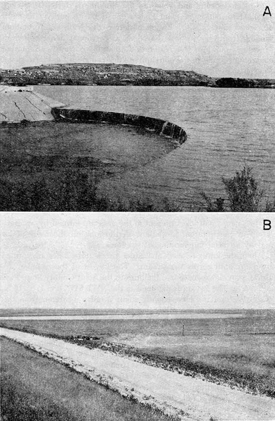
The lagoons range in area from about 1 acre to 300 acres, and the gentle slopes adjacent to the lagoons cover considerably larger areas. In places small gullies have formed on these slopes, but erosion is not marked. Road ditches may carry water for several miles to some lagoons.
Streams
Twin Butte Creek
Twin Butte Creek heads in eastern Wallace County and flows eastward to join Ladder Creek in southeastern Logan County, a distance of 35 miles. The valley formed by Twin Butte Creek is deep and wide and is cut into the Cretaceous rocks along most of its length. Terraces are not well developed; pediment-like surfaces and buttes form the principal erosional features along this stream. Because very little of the land is level along its course, most of the valley is used for grazing. The water in the stream and in nearby wells is strongly mineralized and is used chiefly for livestock. Because the walls of the valley and the tributary draws are moderately steep, and the Cretaceous rocks are virtually impermeable, a large part of the precipitation in this valley runs off. Flood flows, therefore, are of short duration and large volume. Springs and seeps are common along the valley floor and walls, but few of these have been developed for water supplies, and most are merely seepage areas.
Following wet weather, Twin Butte Creek may discharge more than 1 cubic foot per second for several months, but the rate of discharge gradually diminishes until the flow almost ceases. During most of a year of high precipitation there is some discharge in the creek, but in dry years Twin Butte Creek flows only after heavy precipitation.
Chalk Creek
Chalk Creek heads in eastern Wallace County and flows roughly parallel to Twin Butte Creek along the Wichita-Logan County line. The stream is about 40 miles long, and the Chalk Creek valley resembles that of Twin Butte Creek. The stream flows over the Ogallala formation to a point about a mile west of the Scott County line, but downstream from that point the stream is incised into the Niobrara formation. The stream flow probably fluctuates with changes in ground-water levels, which regulate discharge of springs and seeps. Flood flows recharge the stream banks, especially in the area where the stream flows on the Ogallala formation. Such recharge is temporary, and the water is discharged back into the stream after flood runoff has passed.
Hell Creek
Hell Creek begins in Scott County about 9 miles west of the LaneScott County line and 3 miles south of the Scott-Logan County line. The creek flows into Smoky Hill River 3 miles north of the CoveLane County line and 5 miles east of the Cove-Logan County line. The stream has cut a youthful valley in Cretaceous rocks. The valley walls are capped by the Ogallala formation and Pleistocene deposits. Springs maintain a base flow of 1 to 2 cfs in Hell Creek, but during the summer months high evapotranspiration may dissipate this discharge completely in many stretches.
Ladder Creek
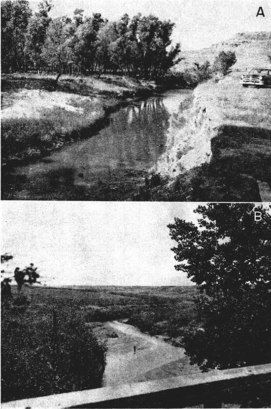
Ladder Creek (Pl. 10) heads about 25 miles west of the ColoradoKansas line, flows southeastward across Wallace County and western Wichita County, thence eastward across eastern Wichita County and western Scott County. Near the midline of Scott County the stream bends northward and flows due north into Logan County and then northeastward to its junction with Smoky Hill River. The stream flows a distance of 100 miles from the head of its longest tributary, North Fork, to Smoky Hill River. South Fork rises a short distance inside Colorado and flows eastward to the Wichita-Greeley County line, where it joins North Fork. An unnamed tributary heads in northwestern Greeley County and joins the main stream 6 miles east of the western border of Wichita County. Sand Creek joins Ladder Creek 6 miles west of the eastern border of Wichita County, after flowing in a southeastward direction from southeastern Wallace County. Twin Butte and Chalk Creeks join Ladder Creek a few miles upstream from its confluence with Smoky Hill River. North and South Forks of Ladder Creek are ephemeral and influent, but downstream a short distance from their junction Ladder Creek is an effluent stream except during extremely dry summers, when evapotranspiration is great enough to intercept any ground-water flow into the stream. Even after a succession of years of abnormally low precipitation, the stream flows during the winter months. The stream is usually dry upstream from the point of effluence except in seasons of heavy rainfall when runoff sustains flow. Twin Butte and Chalk Creeks are the only effluent streams that flow into Ladder Creek.
Plate 1O--A, View looking south at stream-gaging site L-7 north of Lake McBride on Ladder Creek, June 1952. B, View looking southeast downstream on Ladder Creek in western Wichita County.
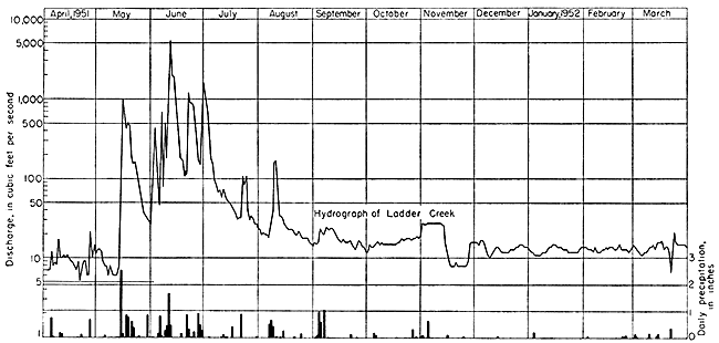
The greatest percentage of flow in wet seasons is provided by surface runoff from seasonal precipitation, which produces a large volume of discharge for a few days. This is illustrated by Figure 5, a hydro graph of Ladder Creek discharge plotted with daily precipitation at Leoti from April 1951 to April 1952. Leoti weather station has continuous records and is closest to the effluent section of Ladder Creek. The lakes in the lower reaches of Ladder Creek impound large quantities of runoff and release it slowly to the stream below the Lake McBride dam. Discharge into the stream from springs and seeps maintains the base flow. Springs are numerous in the Lake McBride area along the contact of the permeable Ogallala and the underlying Cretaceous rock where exposed in the hillsides. Some of these springs have been developed as sources of potable water.
Figure 5--Hydrograph of discharge of Ladder Creek near Elkader compared with daily precipitation at Leoti for the period April 1951 to April 1952.
Flow in Ladder Creek is maintained principally by ground-water discharge, although flooding from melting snow and ice and heavy seasonal rains increases stream flow periodically.
During the fall and winter, the discharge of Ladder Creek is fairly constant except when affected by freezing and thawing. A low winter flow results from a low stage of the water table; similarly, a high winter flow is dependent on a high stage of the water table. Very little water is consumed by evapotranspiration before reaching the stream, nor is there much runoff from precipitation during the winter; consequently the daily discharge of the stream remains fairly constant.
The gain of water from the ground-water reservoir is not uniform along the length of the stream. For this reason, Ladder Creek was gaged at eight sites to determine the distribution of flow. The sites are designated by the letter L and a numeral indicating its position in the series, L-1 being the site nearest the point of effluence and L-8 the site nearest the confluence of Ladder Creek and Smoky Hill River. The sites are not distributed uniformly along the length of the stream, but were established where the hydraulic characteristics of the stream change and where the stream was easily accessible by road. The locations of the gaging sites are shown on Plate 2. Table 3 contains the measured discharges of Ladder Creek in cubic feet per second at the various sites along its length.
Table 3--Discharge measurements at stations on Ladder Creek, in cubic feet per second.
| Date | Station | |||||||
|---|---|---|---|---|---|---|---|---|
| L-l | L-2 | L-3 | L-4 | L-5 | L-6 | L-7 | L-8 | |
| May 3, 1951 | 12.9 | |||||||
| May 28-29, 1951 | 10.1 | 14.5 | 14.9 | 16.3 | 20.7 | 33.4 | ||
| July 24, 1951 | 22.8 | 32.0 | 153.8 | |||||
| July 31, 1951 | 2.0 | 9.5 | 11.3 | 22.0 | 26.0 | 23.3 | 28.5 | 32.5 |
| Nov. 19-20, 1951 | 1.4 | 2.6 | 6.3 | 9.1 | 10.0 | 12.6 | .2d | 4.1 |
| Jan. 9-10. 1952a | 1.3 | 3.0 | 6.4 | 7.1 | 7.0 | 11.6 | 13.0 | 10.0 |
| Feb. 5, 1952b | 7.9 | 8.3 | 7.2 | 8.7 | 14.2 | |||
| Feb. 6-8, 1952c | 1.0 | 1.7 | 4.5 | 6.6 | 7.6 | 8.9 | ||
| Feb. 20, 1952 | 12.8 | 27.4 | ||||||
| Mar. 18-19, 1952c | 7.8 | 13.4 | 14.8 | |||||
| a. Measurements affected by freezing. b. Measurements affected by high winds. c. Because of prior weather conditions, the streamflow on these dates probably was derived from ground water. d. No water flowing over Lake McBride dam because of previous artificial lowering of the lake level. |
||||||||
Smoky Hill River
Smoky Hill River heads in Colorado and flows into the Ladder Creek area as it crosses the Kansas-Colorado border. In Kansas it flows eastward through Wallace, Logan, and Cove Counties. Terraces and pediments border the valley, and the flood plain is narrow. The stream has a braided channel filled with coarse sand, which meanders in a narrow zone in the central part of the valley. The channel is cut into Cretaceous rocks and filled with Pleistocene alluvial deposits. During winter, Smoky Hill River flows below its junction with Rose Creek south of Wallace in Wallace County, and during wet years, above the junction. During the summer, the river is generally dry above Ladder Creek because of evapotranspiration, although Rose Creek flows even during very dry summers.
The large volume of water that flows down this valley during floods inundates only the narrow flood plain. These floods are usually the cumulative result of floods of several tributaries, because a flood on any single tributary would result only in a high level of flow in the main channel. Probably a greater percentage of precipitation on the shorter tributaries becomes runoff because they head in bluffs of impervious Cretaceous rocks. Streams on the upland plains have lower gradients and mature valleys, and part of their flood runoff becomes ground water. A few depression springs and seeps from the Cretaceous rocks discharge a small quantity of ground water into the short tributaries.
Because the valley walls are generally impervious, little ground water is contributed directly to Smoky Hill River. Indirectly, however, all the ground water discharged into streams in the Ladder Creek area joins Smoky Hill River and flows from the area at the eastern boundary.
In the reaches of effluent flow there is little influent seepage from the stream other than the temporary storage of water in its banks. West of this area, however, the stream bed is dry most of the year, and any water flowing over this part recharges the ground-water supply in the permeable alluvium.
During the summer months, transpiration by vegetation growing in the flood plain dries up the stream over much of its length. For example, the gage on Rose Creek often records flow when the gage at Elkader shows none.
The flow of Smoky Hill River is not directly diverted at present (1952), but surface diversions from Rose Creek and future reduction of the ground-water discharge from the Ladder Creek area may substantially reduce the discharge of Smoky Hill River at Kansas highway 23.
Rose Creek
Rose Creek heads about 5 miles south of Sharon Springs in Wallace County and flows 8 miles to its junction with Smoky Hill River about 6 miles east of Sharon Springs. Rose Creek is a spring-fed stream and usually flows even in the driest summers.
Downstream from Rose Creek, Smoky Hill River flows continuously except occasionally in the summer months when the flow from Rose Creek is lost in the Smoky Hill River channel by evapotranspiration. An undetermined quantity of water is diverted from Rose Creek for irrigation.
Salt Creek
Salt Creek flows northward for about 10 miles from its point of origin 3 miles east of Healy in Lane County to its junction with Smoky Hill River. The regimen of this stream is similar to that of Hell Creek. Springs at the base of the Ogallala formation maintain a base flow not exceeding 1 cfs.
Prev Page--Geology || Next Page--Ground water
Kansas Geological Survey, Geology
Placed on web Jan. 29, 2013; originally published December 1957.
Comments to webadmin@kgs.ku.edu
The URL for this page is http://www.kgs.ku.edu/Publications/Bulletins/126/05_surf.html