![]()
Prev Page--Introduction || Next Page--Geology
Geography
Topography and Drainage
The Ladder Creek project area lies almost entirely within the High Plains section of the Great Plains physiographic province. The east end of the area is in the Plains Border section (Fenneman, 1930). Broad upland areas constitute the greatest part of the region under investigation. These areas are loess-covered plains sloping eastward approximately 10 feet to the mile. Many undrained depressions on these surfaces indicate the flatness of the area. These depressions are circular or oval and about 100 to 2,000 feet in diameter.
The fringes of the upland areas are dissected by streams and dry gulches. Major valleys are broad, whereas the tributary valleys are narrow, steep walled, and short.
The major stream in the area is South Fork of Smoky Hill River, which rises about 35 miles west of the Kansas-Colorado line and flows eastward through the area. The flood plain increases from only 2 or 3 miles in western Wallace County to nearly 6 miles in eastern Logan County and western Gove County. Ladder Creek is the principal tributary entering this part of Smoky Hill River from the south. Ladder Creek originates within a mile of the source of South Fork of Smoky Hill River in Colorado and flows eastward, swinging southeastward in Wallace County into western Wichita County and then eastward in eastern Wichita County into western Scott County. In central Scott County, Ladder Creek turns northward, and it joins Smoky Hill River near Elkader in southeastern Logan County. Ladder Creek has a narrow valley and poorly developed terraces in its lower reaches. Other streams in the area flow in a general easterly direction. All the streams have short, narrow tributaries, generally normal to the main valley.
Population
The distribution of population in the Ladder Creek area in recent years has been affected by a general migration from rural areas to the towns. Table 1 gives the population in two northern townships in Scott County and in Scott City.
Table 1--Population of Scott City and Beaver and Michigan Townships, Scott County. [Scott City at 3,816 in 2010, Kansas Statistical Abstract 2011, by KU Institute for Policy & Social Research.]
| Township or City | 1930 | 1940 | 1950 |
|---|---|---|---|
| Beaver Township | 300 | 240 | 220 |
| Michigan Township | 430 | 268 | 215 |
| Scott City | 1,544 | 1,848 | 3,204 |
The population in Wichita and Greeley Counties has been redistributed similarly. The population of Leoti increased from 618 in 1930 to 816 in 1940 and to 1,250 in 1950 [1,534 in 2010], and the population of Tribune increased from 436 in 1930 to 607 in 1940 and to 1,010 in 1950 [741 in 2010]. Sharon Springs in Wallace County declined in population from 792 in 1930 to 760 in 1940 [748 in 2010]. In 1950 the population of Sharon Springs was 994. Many residents left Wallace County during the drought years between 1930 and 1940. The population of the Ladder Creek area probably averages about 1 person per square mile.
Agriculture
The principal industry and source of income in the area is agriculture. In terms of cash income the largest single crop is wheat. The raising of grain sorghums and cattle has increased in recent years. Other crops include barley, corn, alfalfa, oats, sugar beets, potatoes, beans, and various grasses. In previous years climate was a dominant consideration in crop selection, but use of irrigation has stimulated a tendency toward experimentation with crops whose water requirements are not met by precipitation alone.
Climate
The High Plains region has a semiarid continental climate characterized by wide extremes in temperature, variable precipitation, and relatively high winds. The relative humidity is low, averaging between 40 and 50 percent.
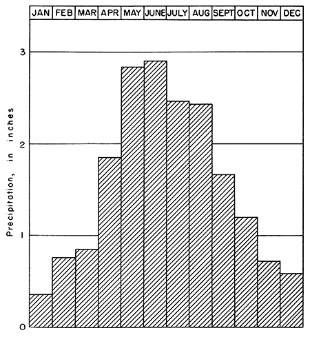
According to the United States Weather Bureau, the normal annual precipitation is 18.61 inches at Scott City. The annual precipitation and cumulative departure from normal precipitation at Scott City are shown in Figure 3; the normal monthly precipitation is shown in Figure 4. Furthermore, Figure 4 indicates that the months of greatest rainfall are May and June.
Figure 3--Graphs showing annual precipitation and cumulative departure from normal precipitation at Scott City.
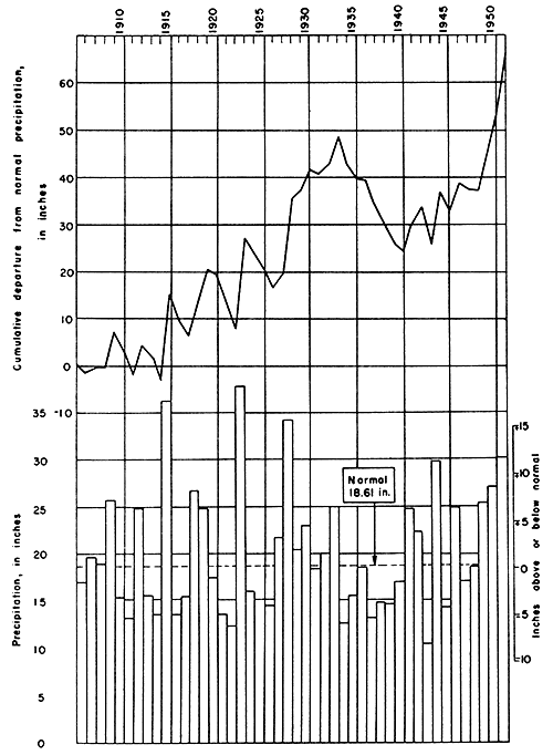
Figure 4--Graph showing normal monthly precipitation at Scott City.
During the late spring and early summer, local showers may be so erratic in areal distribution that one township receives 2 or 3 inches of rainfall while adjacent townships have no rain. Many of these showers are accompanied by electrical storms of considerable violence associated with unstable air masses. Records from 200 first-order Weather Bureau stations from 1899 to 1938 show that in western Kansas, thunderstorms occur on 30 to 50 days per year. Hailstorms frequently accompany thundershowers in western Kansas. Hail is more frequent in wet years than in dry years and results in considerable crop damage. Dust storms are common in parts of the High Plains, especially during prolonged periods of drought.
Much of the snowfall in western Kansas accompanies cold fronts. Not infrequently, strong winds and cold temperatures with accompanying precipitation result in blizzards. Normally, however, these are of short duration, and warmer temperatures follow in a few days. These storms may occur as early as the first of November and as late as the first of May. The snow usually drifts into road ditches and the lee of buildings, while open fields remain bare.
Evaporation is recorded by the United States Weather Bureau by a class A pan at Tribune.
Prev Page--Introduction || Next Page--Geology
Kansas Geological Survey, Geology
Placed on web Jan. 29, 2013; originally published December 1957.
Comments to webadmin@kgs.ku.edu
The URL for this page is http://www.kgs.ku.edu/Publications/Bulletins/126/03_geog.html