![]()
Prev Page--Geography || Next Page--Surface water
Geography
Geology in Relation to Ground Water
[Note: The geologic classification and nomenclature of this report follow the usage of the State Geological Survey of Kansas and differ somewhat from those used by the U. S. Geological Survey.]
The rocks that are exposed in the Ladder Creek area range in age from Cretaceous to Quaternary (Pl. 1). The oldest outcropping rocks are those of the Smoky Hill chalk member of the Niobrara formation. The youngest deposits are clays and silt on the floors of the upland lagoons, alluvium in the stream valleys, and dune sand on the upland.
The physical character and ground-water supply of the geologic formations are described briefly in Table 2. The stratigraphic relations of the formations are shown in the geologic sections in Plate 3.
Table 2--Generalized section of geologic formations in Ladder Creek area
| System | Series | Formation | Thickness, feet | Physical Character | Water Supply | |
|---|---|---|---|---|---|---|
| Quaternary | Pleistocene | Alluvium | 0-65 | Gravel, sand, silt, and clay deposits in major stream valleys. | Yields small amounts of very hard water to wells in the area. | |
| unconformity | ||||||
| Dune sand | 0-40 | Well-sorted fine- to medium-grained eolian sand. Mantles small area on the valley sides and upland divides. | Probably does not supply water directly to wells, but is important as a catchment area for ground-water recharge to adjacent and underlying formations. | |||
| unconformity | ||||||
| Sanborn and Meade formations, undifferentiated | 0-150 | Predominantly tan to brownish loess underlain by clay, silt, volcanic ash, and thick sand and gravel in buried valleys, terraces, and slope deposits. | Generally occurs above the water table and is relatively impermeable. Gravel terrace deposits yield small Quantities of water to a few wells, and where thick, as in buried valleys, the formation is highly productive. | |||
| unconformity | ||||||
| Tertiary | Pliocene | Ogallala formation | 0-250 | Arkosic gravel, sand, and silt locally cemented with calcium carbonate to form resistant "mortar beds", massive to cross-bedded bentonitic clay, fresh-water limestone. Individual beds generally lenticular. Underlies most upland areas. | Yields moderate to abundant supplies of good-quality but hard water to most wells in the upland area. Constitutes the principal source for most of the irrigation wells in the area. | |
| unconformity | ||||||
| Cretaceous | Gulfian | Pierre shale | 0-600 | Thin-bedded, fissile clayey shale, black to dark gray. weathering yellowish brown to gray; contains concretions of selenite, thin beds of bentonite, and local calcareous lenses. Marine fossils common. | Relatively impermeable; not known to yield water to wells in area. | |
| Niobrara formation |
Smoky Hill chalk member | 100-700 | Interbedded soft chalk and chalky shale; thin local limestones, marine vertebrate and invertebrate fossils; gray, weathering to yellow and red, thick weatherd zone present near top in most places. | Yields small supplies of very hard water to a few wells in areas where younger, more permeable water-bearing rocks are absent. | ||
| Fort Hays limestone member | 50-60 | Massive chalky limestone; thin shale partings and abundant invertebrate fossils. Not exposed in area. | Not known to yield water to wells in area. | |||
The Niobrara formation and Pierre shale form a nearly impervious floor overlain by permeable Tertiary Ogallala formation and, in places, Quaternary deposits. The principal water-bearing formation is the Ogallala formation. In the buried stream valleys, Quaternary deposits are the principal source of ground water. In an area just north of Scott City both Quaternary and Tertiary (Ogallala) deposits consist of water-bearing materials.
Cretaceous System--Gulfian Series
Niobrara Formation
Fort Hays limestone member--The Fort Hays limestone member is a massive gray marine limestone, about 60 feet thick, at the base of the Niobrara formation. The member is not exposed in the Ladder Creek area, and no wells in the area are known to derive water from the member.
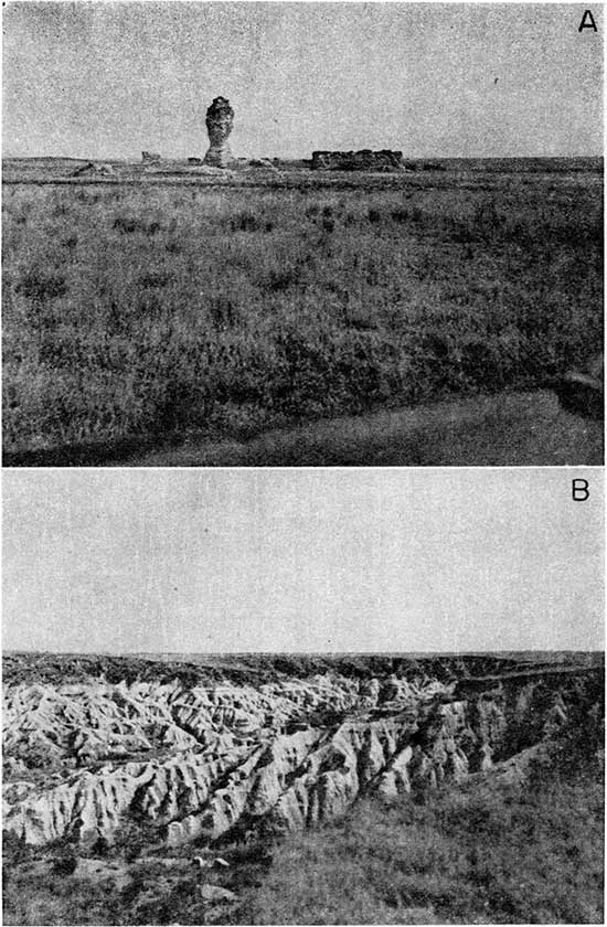
Smoky Hill chalk member--The Smoky Hill chalk member of the Niobrara formation (Pl. 6) is the oldest rock unit that crops out in the Ladder Creek area. The member is composed of shaly chalk containing concretions of limonite and pyrite. It is generally gray but weathers to bright hues of yellow, red, and white. The member is about 700 feet thick in Logan County (Moore and others, 1951, p. 24) and is exposed along most of the major streams and their tributaries in the Ladder Creek area.
Plate 6--A, "Sphinx" in southwestern Gove County caused by differential erosion of the Smoky Hill chalk member of the Niobrara formation. B, Typical badlands topography on the Smoky Hill chalk member of the Niobrara formation in the western half of sec. 30, T. 15 S., R. 30 W., Gove County.
The following section measured by A. R. Leonard and K. L. Parish in Logan County is typical of this member in the Ladder Creek area.
| Measured section of Smoky Hill chalk in sec. 17, T. 15 S., R. 34 W., Logan County | Thickess, feet |
|---|---|
| Covered slope containing fragments of chalk, some silicified, scattered in the soil | 10.0 |
| Chalk, slightly shaly in lower part, in thick beds weathering to a platy structure, orange to buff weathering buff to light gray. A thin bentonite parting occurs 10.6' feet above the base. Also local, thin red beds in lower part | 16.5 |
| Chalk, massive, blocky, orange to buff, containing a thin bentonite zone | 5.5 |
| Bentonite, mottled gray to orange | 0.3 |
| Shale, chalky, thin bedded, soft, orange to buff, weathering to a platy structure somewhat lighter in hue | 3.0 |
| Chalk, in very thick massive beds having blocky, thin shale and bentonite partings; dense, resistant, contains some fossil oysters | 9.0 |
| Chalk, shaly, in beds 0.6 to 1.2 feet thick, orange to buff, weathering to soft slabs | 6.8 |
| Shale, chalky, thin bedded to massive, containing prominent local gypsum layers; light orange; differential weathering of the beds. Prominent vertical joints contain soft filling. Pelecypods and fish scales found in this zone | 27.0 |
| Chalk, shaly, contains abundant discoidal ferruginous concretions arranged in layers. Bedding planes and cracks filled with gypsum. This zone weathers light gray and buff, is thin bedded, and dissected by innumerable small fractures; some small carbonaceous seams. A dense, limy, more resistant zone 14 to 16 feet above base of section. Some bentonitic and limonitic zones and accompanying flat gypsum concretions. The chalk is softer, more massive, and less silty in the upper part and has prominent gypsum layers | 58.0 |
| Base of section is covered. | |
| Total section measured | 136.1 |
From the eastern limit of the area to the eastern part of Wallace County, the Niobrara formation is exposed along the valley walls of Smoky Hill River and along the tributaries that intersect the steeper part of the bluffs of the main valley. In the western part of the area, near the town of Wallace, the Niobrara formation is overlain by the Pierre shale.
In upland areas the Niobrara formation is mantled by the Tertiary Ogallala formation and by loess of the Quaternary. In the stream valleys, channels cut into the formation are filled with alluvium and Sanborn and Meade deposits. In many places in the Smoky Hill River valley and in a few of its tributaries, broad graded surfaces slope up gently and uniformly from a low terrace, or some intermediate level, to the steep bluffs along the fringes of the upland. These surfaces are underlain by the Niobrara formation mantled by alluvial wash and locally by loess. Frye and Smith (1942) suggested that these surfaces originated from planation by small side streams, back-weathering of bluffs, rill cutting, and sheet wash.
The Smoky Hill chalk member of the Niobrara formation is not a major aquifer in the Ladder Creek area, but supplies water to a few wells in areas where no other water-bearing rocks are present except at great depth. The water is very hard, may be unpalatable, and only meager supplies are obtained. No irrigation or municipal supplies are derived from this chalk. The Niobrara formation is an effective aquiclude, confining most of the ground water to permeable materials overlying it.
The Smoky Hill chalk member contributes some ground water to the alluvium and streams of valleys incised into it, but the water is strongly mineralized. For this reason, water for household use on many farmsteads in these valleys must be hauled from other areas. The water derived indirectly from the Smoky Hill chalk member is used only for livestock.
Pierre Shale
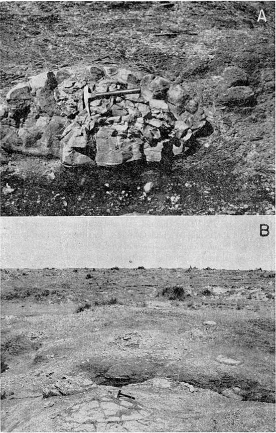
The Pierre shale is a dark-gray fissile shale interbedded with bentonite, limonite, gypsum, and lenticular limestone and contains numerous septarian concretions (Pl. 7). A part of the stratigraphic section was studied and measured by C. R. Johnson and N. W. Biegler a few miles south of Wallace, Kansas.
| Measured section of Pierre shale in sec. 7, T. 14 S., R. 38 W., Wallace County. | Thickess, feet |
|
|---|---|---|
| Base of Ogallala formation | ||
| Shale, yellow and brown mottled, limestone concretions near contact; fish scales interspersed | 10.5 | |
| Shale, gray and fissile, having white, powdery material in fractures. Weathers to a lighter gray | 11.6 | |
| Shale, gray and brown, fissile, containing lenticular silty limestone concretions as much as 7 inches in diameter | 1.0 | |
| Shale, fissile, blue gray | 6.5 | |
| Bentonite, having yellow limonitic shale partings | 0.5 | |
| Shale, blue gray, containing lenticular limestone bodies as much as 1/2 foot thick and 6 feet long | 3.5 | |
| Shale, blue gray and fissile, containing abundant bentonite stringers. A limonitic, resistant persistent bed )f inch thick lies at base | 10.2 | |
| Shale, brown, limonite; containing many limy concretions as much as 3 inches in diameter | 0.6 | |
| Shale, blue gray, weathering yellow brown and earthy, fissile; bentonite stringers as much as 1/2 inch thick are common; contains fish scales. Gypsum crystals in platy aggregates are numerous | 29.0 | |
| Total section measured | 73.4 | |
Plate 7--A, Septarian concretion in the Pierre shale in the SE NW sec. 36, T. 13 S., R. 40 W. B, Exposure of Pierre shale in Wallace County, showing weathering of the septarian concretions from the enclosing shale.
The above section probably is comparable to the middle part of the Pierre shale described by Elias (1931).
The Pierre shale crops out in Wallace County and western Logan County where the Ogallala formation has been removed by erosion. In eastern Logan County there are isolated outcrops where the Cretaceous rocks have been faulted. Low rolling slopes are developed on exposures of the Pierre shale.
The thick Pierre shale is not a source of ground water for wells in the area. The formation serves as an aquiclude, confining the ground water to the formations above it.
Tertiary System--Pliocene Series
Ogallala Formation
The deposition during the Cretaceous was followed by uplift and erosion during the earlier epochs of the Tertiary. Many of the marine deposits of the earlier period were stripped off by erosion, and by the beginning of Pliocene time a drainage pattern was well developed on the Cretaceous rocks. The main channels of this drainage system enter the area as two branches that join approximately 8 miles southwest of Sharon Springs in Wallace County (Pl. 1). This channel extends southeastward across the rest of Wallace and Wichita Counties, and then eastward across Scott and Lane Counties. The channel is joined by still another tributary channel trending eastward across northern Greeley County.
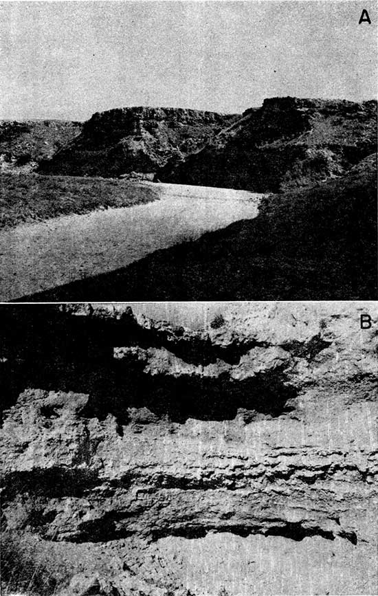
The Ogallala formation (Pl. 8A) was laid down as the heterogeneous deposits of streams following these channels and consists of gravel, sand, silt, clay, and a durable fresh-water limestone. The stratification is lenticular, and individual beds are difficult to trace lithologically. Many of the sand and gravel beds, especially in the lower part, are unconsolidated. Typical of the formation are the beds referred to by drillers as "mortar beds", "caliche", and "gyp-rock", which are silt, sand, gravel, and cobbles poorly sorted and weakly cemented with calcium carbonate. A zone of limy material near the top of the formation contains siliceous concretions or nodules. In places the cement binds a large part of the zone, making a very weather-resistant bed. At the top of the formation a hard fresh-water "algal" limestone has been deposited. The following section measured by C. R. Johnson and N. W. Biegler in Wallace County is typical.
Plate 8--A, Typical bluffs of the Ogallala formation along Ladder Creek near the Wallace-Greeley County line in sec. 36, T. 15 S., R. 39 W.; view facing southeast. B, Exposure of Ogallala formation in cliff.
| Measured section of the Ogallala formation in sec. 7, T. 14 S., R. 38 W., Wallace County. | Thickess, feet |
|
|---|---|---|
| Soil zone | 0.7 | |
| Silt and brownish sand, containing limestone fragments | 1.0 | |
| Ogallala formation | ||
| Algal limestone, Chlorellopsis bradleui, pink to white, weathering to large cobbles and boulders, hard and resistant | 2.0 | |
| Limestone, dense, hard, gray to white, contains many siliceous concretions and pieces of agate; whorls and knobs are typical of the structure of the limestone; some small quartz and feldspar pebbles; some lenticular bodies of siliceous material as much as 6 feet in length, weathering into blocks. Entire zone forms a prominent ridge | 23.2 | |
| Sand, fine to coarse, cementation varying laterally from none to fairly dense; round, sandy unconsolidated bodies surrounded by well cemented rock; virtually no sorting or bedding; general color of this zone is reddish buff, light in hue, becoming more red at top. Fossil roots are very abundant, and hackberry seeds are found 3 feet above base of zone | 18.5 | |
| Gravel, coarse, and sand, well cemented, gray, containing large bodies of un cemented material; poorly sorted and showing extreme local variation both laterally and vertically; large tubular concretions common | 9.3 | |
| Sand, medium to fine, silty, red to reddish brown; contains undulate masses of white limy material that in places constitute more than half of the zone and incorporate disseminated sand and fine gravel; some interbedded cemented sands. Fossil roots are common | 4.0 | |
| Limestone conglomerate, dense, and sand, gravel, and cobbles dispersed through a light-colored matrix. The pebbles are quartz and feldspar, and both acidic and basic igneous rocks, all well rounded. Most of these pebbles are less than 1/2 inch in diameter, but some attain a size of 3 inches. There is very little sorting except for faint cross-bedding. The exposure is resistant, weathering to a vesicular texture and a buff color | 11.6 | |
| Siltstone, massive, forms prominent ledge, contains spherical masses of gravel, lenses of silt, clay, and sand, and fossil roots | 2.9 | |
| Clays, interbedded, and unconsolidated sands. Some of the sands are limonitic and very well sorted; some massive siltstones contain clayey masses | 2.7 | |
| Sand, cemented, and fine gravel in lumpy, nodular masses; contains much unconsolidated fine sand | 2.9 | |
| Sand, and some gravel, containing silt and clay, in massive beds, poorly cemented and sorted, and nodules or lumps of fine material. In a few places black sand and coarse gravel lenses and zones of cross-bedding and dense cementation, some limestone nodules and tubular concretions. A complete skeleton of a horse was collected approximately 12 feet above base of section. Zones of abundant fossil fruits about the size of hazel nuts. This part of the exposure is light tan to grayish pink | 26.7 | |
| Pierre shale | 84.6 | |
| Total section measured | 190.1 | |
The thickness of the formation differs from place to place because of the irregularity of the underlying Cretaceous surface and the erosion of the upper part of the Ogallala during the Pleistocene epoch. The maximum thickness of the Ogallala in the Ladder Creek area is about 250 feet, noted near the Colorado-Kansas line.
The Ogallala formation is the principal aquifer in the area. The selection of location of wells from which high yields are required, such as irrigation and municipal wells, generally is preceded by extensive test drilling to determine the most permeable parts of the aquifer and the greatest thickness of water-bearing materials.
Quaternary System--Pleistocene Series
Sanborn and Meade Formations Undifferentiated
During early Pleistocene time, a new drainage system developed on the surface of the Tertiary deposits. This Pleistocene drainage did not reach the same stage of maturity as the Tertiary drainage on the Cretaceous sediments. Even though many of these valleys cut entirely through the Tertiary deposits and are partly cut into the underlying chalk and shale, the interstream areas are only partly dissected and poorly drained. Most of the present drainage is inherited from this earlier Pleistocene drainage, the present valleys following the valleys initially incised by earlier streams. An exception is a deep valley trending southward through Scott City, which was cut by a Pleistocene stream but now is almost filled by fluviatile deposits and no longer contains a stream. This valley was filled during the same depositional cycle as that in which the other valleys existent at the time were partly filled. As the streams in these valleys cut down, materials laid down during earlier depositional cycles were left high on the valley walls as terraces and fillings of earlier channels. This cycle of down cutting was followed by eolian deposition of silt that mantled the entire area.
The Pleistocene deposits of the Ladder Creek area include two formations, the Meade and the Sanborn. The Meade formation is divided into an upper eolian unit of sandy silt and clay containing a persistent volcanic ash bed and lower unit of sand and gravel. The Sanborn formation overlies the Meade formation and consists of yellowish-gray loess containing sand and gravel at the base in some areas. Both formations are generally unconsolidated. The maximum combined thickness is 150 feet, noted in the buried valley north of Scott City. In this report the Sanborn and Meade formations are not differentiated, and inasmuch as the Meade is generally covered in the Ladder Creek area, it is not distinguished on the geologic map, Plate 1.
Ground-water supplies are generally available from the Meade and Sanborn formations where sufficient saturated thickness of permeable material is present. Irrigation wells of large yield have been developed in them in the terraces of Smoky Hill River and in the large buried channel in Scott County. The Meade and Sanborn formations probably are generally more permeable than the Ogallala formation, but are thinner and of smaller areal extent. They rank second to the Ogallala formation as a source of ground water in the area.
The silty upland mantle of loess does not contribute water to wells, but the manner of deposition by wind action has created a poorly drained topography marked by many shallow depressions. These depressions collect water during heavy precipitation and may thus transmit considerable recharge to the underlying Ogallala formation in the Ladder Creek area.
Dune Sand
Dune sand and some associated silt have been derived by wind action from sandy parts of the upland Pleistocene deposits, especially where these deposits have been partly dissected by small upland ephemeral streams. Where vegetation is thin or where precipitation is not sufficient to support a grassy turf, the material is shifted by wind into new dunes.
Sand-dune areas are most prevalent in Greeley and Wallace Counties. Although small in extent, they form excellent recharge areas for underlying aquifers because of their high permeability and poor surface drainage. They lie above the zone of saturation, however, and therefore are not a source of water for wells in the area.
Alluvium
The main streams at one time cut channels into the bedrock, and in them have subsequently been deposited thick beds of fluviatile material to "form the present valleys. These deposits include sand, gravel, silt, and clay, and they are generally unconsolidated, although some slight compaction has occurred in the deeper parts. Because of the nature of stream deposition, the constituent materials have been roughly sorted into discontinuous lenses or cross-bedded irregular masses of small extent. Generally the coarser gravels lie on the bedrock floors of the valleys. In places these gravels are extremely calcareous and become firmly cemented when dry. Thick beds of clay interbedded with sand are common beneath the floodplains, whereas thick beds of sand and gravel are generally present beneath the stream channels.
Most of the sand and gravel in the alluvium is derived from the Ogallala formation or from Pleistocene deposits partly composed of reworked Ogallala. Fragments from the Niobrara formation, ranging from clay to large boulders, are common in the alluvium of valleys cut into the Niobrara formation, however. Septarian concretions found in the alluvium are derived from the Pierre shale. Fine clay in the alluvial material also may be derived from the Pierre.
The alluvium is an important aquifer in the Ladder Creek area. It fills valleys cut into the Ogallala formation, and the two formations are in hydraulic contact over wide areas. The alluvium lying between a stream and the Ogallala permits water from the Ogallala formation to discharge through the alluvium into the stream; conversely, when the stream is flooding in normally dry areas, the Ogallala formation is recharged from the stream by way of the alluvium. Thus, the alluvium serves as a conduit or medium for ground-water flow between the Ogallala formation and streams.
Prev Page--Geography || Next Page--Surface water
Kansas Geological Survey, Geology
Placed on web Jan. 29, 2013; originally published December 1957.
Comments to webadmin@kgs.ku.edu
The URL for this page is http://www.kgs.ku.edu/Publications/Bulletins/126/04_geol.html