Kansas Geological Survey, Bulletin 114, part 2, originally published in 1955
Originally published in 1955 as Kansas Geological Survey Bulletin 114, part 2. This is, in general, the original text as published. The information has not been updated.
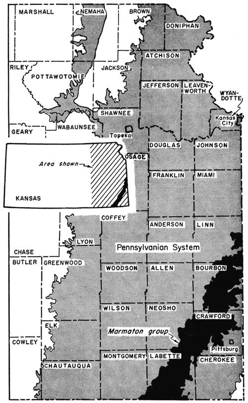
The Marmaton coal-bearing rocks lie directly above the "Cherokee" or main coal-bearing strata in southeastern Kansas and constitute the upper part of the middle Pennsylvanian rocks in Kansas. The coal-bearing rocks crop out in a belt 10 to 25 miles wide extending in a general northeast-southwest direction from Linn and Bourbon counties on the north to Montgomery and Labette counties on the south. Of the 8 to 10 coal seams in the group, only the Mulberry seam in the Bandera shale formation approximately in the middle of the group is being mined. A second coal seam, the Summit, in the Fort Scott limestone formation at the base of the Marmaton group is reported to have been mined although field evidence reveals no trace of mines nor outcrop of minable coal.
The Mulberry coal has been mined in Linn and Bourbon counties, but currently is mined commercially only in Linn County, which ranks third among the coal-producing counties of the State. The coal ranges in thickness from 1 to 4 feet where mined and is thickest in the northern and western parts of the coal-bearing area. The coal lies close to the surface and at depths reaching 120 feet. Currently, virtually all the coal is mined by stripping. The Mulberry is a bituminous coal of high volatile A to B rank. Proximate analyses show B.T.U. value on a moisture- and ash-free basis ranging from 14,200 to more than 15,000, which compares favorably with other Kansas commercial coals. The Mulberry coal can be used for all general purposes. It is estimated that 9,407,000 tons of Mulberry coal has been mined in Linn and Bourbon counties since 1872. Measured coal reserves are calculated at 221,230,000 tons, indicated reserves at 651,264,000 tons, and inferred reserves at 924,000,000 tons, a combined total of 1,796,490,000 tons of all reserve coal. Of the 221,230,000 tons of original measured reserves, 112,547,000 tons is considered recoverable by stripping and 16,649,000 tons minable by underground mining methods. The inferred coal reserves, which are estimated to underlie 703 square miles, extend into Miami, Allen, and Neosho counties.
This report describes the geographic distribution, stratigraphic position, thickness, contact rock, and physical and chemical characters of the Mulberry coal and includes information on the history of Marmaton coal mining, mining methods, production, and coal reserve data. The report consists of two parts. The first part deals with the Mulberry coal in general, whereas the second discusses in detail the occurrence, mining, mining districts, production, and reserves in Linn and Bourbon counties.
Map of Linn and Bourbon counties, Kansas, showing location of Mulberry coal mines, mining districts, and reserve coal areas, and a generalized stratigraphic section of the Marmaton group of rocks
Coal ranks seventh in value among the mineral resources of Kansas. In 1953 coal production amounted to 1,720,306 tons valued at approximately $6,881,000. Of this 486,585 tons were Mulberry, all of which was mined in Linn County. Mulberry coal is known to occur also in Bourbon and Miami counties. On the basis of this investigation, reserves of minable Mulberry coal remaining beneath the surface in Linn and Bourbon counties, the only counties in Kansas in which minable or measured Mulberry coal occurs, are estimated at 221,230,000 tons as of December 31, 1953. Of this total, 129,196,000 tons is recoverable. In addition, an area exceeding 281 square miles is underlain by indicated coal reserves, which total more than 651,000,000 tons. The inferred or potential Mulberry coal reserves, which also extend into Miami, Allen, and Neosho counties, are calculated to amount to 924,000,000 tons.
Just when the Marmaton coal was first discovered is not known. Coal, however, was known in eastern Kansas before Kansas became a state on January 29, 1861. As early as 1854 Hale (p. 87) stated that "The great coal-fields of Missouri, south of the Missouri, extend thirty or forty miles into Kanzas." It is certain that coal mining almost everywhere in eastern Kansas was contemporaneous with the establishment of the first towns in the late 1850's.
Purpose of study--This report is the seventh of a series on Kansas coal started by the State Geological Survey of Kansas in 1942. This report describes the coal resources of the Marmaton group of rocks, which directly overlies the "Cherokee" or main coal-bearing strata in the State.
The other inventory coal reports thus far published include the coals of the Douglas group (Bowsher and Jewett, 1943), the Kansas City group (Schoewe, 1944), the Wabaunsee group (Schoewe, 1946), the Permian System (Schoewe, 1951), and the Cretaceous (Dakota) lignites (Schoewe, 1952), and the coal reserves in Kansas (Abernathy, Jewett, and Schoewe, 1947). In addition, Abernathy (1944) reported on mined areas of the Weir-Pittsburg coal and on the strip-mined areas in the Southeastern Kansas coal field (Abernathy, 1946). Earlier publications dealing solely with coal include reports by Whitla (1940), Pierce and Courtier (1937), and Haworth and Crane. (1898). Other papers treating the subject include the report by Young and Allen (1925), a report on current coal research in Kansas by Schoewe (1951), and the most recent a report by Hambleton (1953) on the petrography of southeastern Kansas coals. A comprehensive bibliography pertaining to coal in Kansas was prepared by Schoewe (1944, pp. 133-136).
Previous work--First record of mining coal of the Marmaton group dates back to 1858 when coal was reported to have been mined 2 1/2 miles north of Prescott in Linn County. In 1863 coal was mined near Mound City, also in Linn County. As early as 1864 Mudge (1866, pp. 9, 20), first state geologist of Kansas, observed outcrops of the Marmaton coal (Mulberry) as much as 3 feet thick in the banks of Marais des Cygnes River in Linn County near the Kansas-Missouri state line. This same coal, he observed, also cropped out on the banks of Little Osage River in Bourbon County and "in various places in a southwesterly direction across the State into the Indian Territory." The coal also crossed into Missouri in a northeasterly direction where it was mined at Lexington on Missouri River. According to Mudge the coal was of good quality, better on the average than most of the other coals he had seen. He believed that the coal (Mulberry) observed on the banks of Marais des Cygnes River was the same as the coal penetrated in the Leavenworth coal shaft and in borings sunk under the direction of Hawn and Swallow and designated in his section as bed 14, which consisted of 13 feet of bituminous shale and coal. It is to be noted, however, that the coal seen by Mudge southwest of Marais des Cygnes and Little Osage Rivers extending across the State into what is now Oklahoma is not all Marmaton coal. Swallow (1866, pp. 22-24, 56, 81, 89), second state geologist of Kansas, likewise noted the Marmaton coals, and briefly indicated their thickness and character and the fact that the coal was mined, selling for 25 cents a bushel or $6.25 a ton. Hawn (1866, p. 111), in reporting on the geology of Linn County, also noted the Marmaton coals of Linn and Bourbon counties and correlated the Bourbon County coals with those of Linn County.
Before 1860 coal was known to exist at Fort Scott in Bourbon County (Malin, 1950, p. 87), and it was advertised to advantage by the Fort Scott Town Company in promoting their townsite. The Fort Scott Town Company claimed "The country around Fort Scott abounds in coal of the very best quality. It crops out from nearly every hill and underlies the townsite. It is in general use in town for fuel." The coal that is mined today at Fort Scott is not a Marmaton coal but the Mulky coal in the uppermost part of the "Cherokee" rocks a few feet below the base of the Fort Scott limestone, which marks the base of the Marmaton group of rocks. [Note: The Geological Surveys of Iowa, Kansas, Missouri, and Oklahoma have agreed to apply the names Krebs group to lower Cherokee rocks and Cabaniss group to the upper part. However, in this report those Pennsylvanian rocks below the Fort Scott limestones are referred to as "Cherokee" rocks.] Undoubtedly the Summit coal, which lies between the two limestone members of the Fort Scott limestone and which is but a few feet above the "Cherokee" Mulky coal, must have been observed in the hills around Fort Scott at this early date. Even before 1860, outcrops of Marmaton coal must have been observed, especially along the banks of Marais des Cygnes, Little Osage, and Marmaton Rivers, as all early reports concerning eastern Kansas emphasized the presence of coal, particularly because of the general absence of timber and other possible sources of fuel in the territory (Hale, 1854, p. 87; Malin, 1950, pp. 65, 67, 75). In 1878 Mudge (pp. 72, 86) concludes that, although the limestones of the coal measures are persistent over large areas, the coal seams, especially those of the Marmaton group, are very irregularly distributed, appearing and disappearing very erratically, the absence of the coal being due to erosion or to nondeposition because of islands in the coal-forming swamps. The Mulberry coal, according to Mudge, was of medium quality, rich in gas, yielding 8,000 to 9,000 cubic feet per ton, coked well, and burned with a clear flame, but contained some pyrite and other impurities; it ranged from 13 to 33 inches in thickness. It was mined in Bourbon and Linn counties, from which it was shipped by the car load as early as 1872. It seems from the early reports that the Mulberry coal of the Marmaton group was not always distinguished from the Mulky coal of the "Cherokee" in Bourbon and Linn counties, the two seams being regarded as one and the same coal. Saunders (1873), who probably was one of the first to make chemical analyses of Kansas coals, as early as 1872 in discussing the coals of Kansas wrote that there was a fine vein of coal about 30 inches thick that cropped out in northern Bourbon County from which place it extended to the northeast and southwest. According to Saunders this vein, called the "Osage" vein and also the Fort Scott coal, appeared in commerce under two names--black and red. The red coal is today known as the Fort Scott or Mulky coal, whereas the black coal, which also yielded considerable gas, is probably the Mulberry coal. The miscorrelations are readily understood when it is realized that the two seams are separated vertically (stratigraphically) from each other by only a few feet of other rock. The search for coal in Linn County was in earnest, for in 1881 a few citizens of LaCygne subscribed $1,000 and gave it to a Mr. George Morely as a bonus to prospect for coal at LaCygne and vicinity. Mr. Morely's success in finding a 36-inch seam of coal at a depth of 120 feet half a mile north of the town stimulated the formation of another stock company, which likewise was successful, finding coal in the south part of the town (Andreas, 1883, p. 1113). Nothing of much scientific value relative to the Marmaton group coals is to be found in the early reports published mainly by the Kansas State Board of Agriculture, before 1895, at which time detailed stratigraphic studies of Kansas rocks were begun by the University Geological Survey.
The first report on the coals of the Marmaton group of strata was Haworth's (1895) report on the coal fields of Kansas. In this report the coal-bearing Bandera shales were called the Lower Pleasanton shales. Although the exact geologic horizons at which the Marmaton coals occur were not determined, effort was made at many places to locate definitely some of the coal horizons, including those in Linn and Bourbon counties. Much of the same information was subsequently incorporated in Haworth and Crane's "Special Report on Coal" published in 1898. Haworth and Crane described the coal-bearing rocks and the economic, statistical, and historical aspects of the coal. Much of the material in this report is repeated from Haworth's earlier papers and those of Bailey (1889) and Blake (1889), who were primarily concerned with the composition of the coals; they included in their reports four analyses of Marmaton coals from Linn and Bourbon counties. A report by Young and Allen (1925) brings up-to-date much of the information presented by Haworth and Crane in 1889 and includes proximate and ultimate analyses of Linn and Bourbon County coals. Moore (1929) presents a general description of the Marmaton coal-bearing area. In 1937 Pierce and Courtier (pp. 48-79) mention the presence of coal in the Fort Scott limestone and in the Labette shale in Bourbon and Crawford counties. As these coals are not of minable thickness, no further reference to them is made.
A useful, though generalized, contribution to reports on the Marmaton coals is a report by Whitla (1940), in which he discusses briefly the history of mining in the Pleasanton district; presents generalized descriptions of the Summit, Lexington, and Mulberry coals; and discusses the coals in Bourbon and Linn counties. Whitla states that the Summit coal, which occurs in the Fort Scott limestone formation at the base of the Marmaton group of rocks, is mined along the tributaries of Little Osage River in northeastern Bourbon County 3 to 4 miles east and 4 miles north of Hammond. Field investigations reveal, however, that the coal mined in the Hammond area lies beneath the Fort Scott limestone and is therefore not the Summit coal as supposed but the Mulky coal in the uppermost part of the "Cherokee" rocks. Whitla also points out that a coal near the middle of the Labette shale, which has been called the "Lexington" coal in Kansas, is not the equivalent of the Lexington coal that is mined at Lexington, Missouri. The Missouri Lexington coal, which is the uppermost commercial coal mined in Missouri, lies near the top of the Labette shale beneath the "Lexington cap-rock" or lowest member of the Pawnee limestone formation. The true Lexington coal seam in Kansas is too thin to be mined.
A paper by Jewett and Schoewe (1942, pp. 80-82, 86-88) refers to the Marmaton coals, briefly discussing the history of the eastern Kansas coal field, its products, and coal resources. The latest report concerning Marmaton coal is by Abernathy, Jewett, and Schoewe (1947), who estimated the proved (measured and indicated) and potential or inferred coal reserves of the Summit and Mulberry coals in the State.
Besides the papers by Bailey and Blake, proximate analyses of Marmaton coals are given by Moore (1929) and Allen (1925). The stratigraphy of the Marmaton coal-bearing rocks is described in several recent Survey publications, all of which mention the various coal seams but do not attempt to describe the coals. Of these reports two by Jewett (1941, 1945) are the most important. The other reports are by Moore (1936, 1949) and Moore and others (1944, 1951). Of earlier reports on the stratigraphy of the Marmaton group of rocks as now classified the one by Adams, Girty, and White (1903) is the only one referring definitely to the stripping of coal which was being done in the vicinity of Prescott in Linn County. According to Adams, Girty, and White (1903, p. 31) the stripped coal near Prescott measured 6 to 8 inches in thickness and occurred in the Labette shales. Coal in the Bandera shale was not known to be persistent for any considerable distance.
Statistical information on the Marmaton coals is given in the various reports of the Kansas coal and metal mine inspectors; U. S. Geological Survey, Mineral Resources of the United States, 1882 to 1923; U. S. Bureau of Mines, Minerals Yearbook, 1924 to 1950, Kansas State Board of Agriculture, Annual Reports 1 to 5 (1872-1876) and Biennial Reports 1 to 9 (1878-1895); and the University Geological Survey of Kansas annual bulletins on mineral resources of Kansas for 1897 to 1903.
Field and laboratory investigations--Field work that forms the basis for this report was started in July 1950 and was carried on intermittently during that month. More intensive investigations were resumed in July 1951 and continued to August 25 except when excessive rains and flood conditions prevented work in the field. Field investigations were completed in the summer of 1952. Effort was made to trace and locate all Marmaton coals throughout the Marmaton coal-bearing area. The stratigraphic position, occurrence, physical nature, and thickness of the coals, the character of contact rocks, and the nature and thickness of overburden were studied in the field. All active and abandoned mines were located on maps. Data concerning production, mines, mining methods, and history of mining were obtained from old settlers and miners living in the mining district and from various State and Federal publications. Air photographs were used in obtaining the location, size or area, and pattern of the larger strip-pit mines. Coal samples were collected from five mines and two outcrops. The samples were analyzed in the geochemistry laboratories of the State Geological Survey under the supervision of Russell Runnels. Other proximate analyses were supplied by the Hume-Sinclair Coal Company and still others were taken from published reports.
Acknowledgments--John M. Jewett of the Survey staff spent two days in the field with me aiding in the stratigraphic aspects of the investigation. Much help relative to the location and history of many of the old abandoned mines was obtained from local residents of the coal-mining districts. Special thanks are due to the late Mr. John Pelligreno of Pleasanton, former State coal mine inspector during 1914-1916, who not only spent part of a day with me in the field aiding in the location and identification of many of the former mines but who also provided considerable data relative to their depth, thickness of coal, and time of operation. Mr. John Smith of Pleasanton and Mr. Lloyd Kite of Prescott aided materially by providing information relative to the mines in Linn and Bourbon counties, as did Mr. C. M. Draper of Redfield in Bourbon County. Special appreciation is due to Mr. Dean Evans of Mound City, Linn County, and Mr. Raymond Mowry and Mr. Clarke Crowder, both well drillers and contractors at Fort Scott, Bourbon County, for subsurface information and the use of well logs. Mr. Merle Guthrie, former mine superintendent of the Hume-Sinclair Coal Company, rendered invaluable assistance in connection with mapping the large strip pits operated by his company near the Kansas-Missouri state line. The Hume-Sinclair Coal Company also supplied eight proximate chemical analyses of the coal mined in their strip mine east of Prescott and also brought up-to-date on a map the extent of their stripping operations after field work for this report was completed. To this company I am greatly indebted for their extremely helpful cooperation and contribution. I wish to express my appreciation to the P.W.A. officials of Mound City, Linn County, and Fort Scott, Bourbon County, for the use of their large-scale air photographs of the counties, from which the location, size, and pattern of the larger strip pits were taken.
The Marmaton group of rocks crops out in a belt 10 to 25 miles wide extending in a general northeast-southwest direction from Linn and Bourbon counties on the north to Montgomery and Labette counties on the south (Fig. 1). The general strike of the group is N. 30° E. and the dip towards the west averages 20 feet to the mile (Moore, 1949, p. 49). Marked deviations from the prevailing structure occur, however, especially in Linn County.
Figure 1--Map of eastern Kansas showing outcrop area of the Marmaton group of rocks.
Physiographically the Marmaton group of rocks crops out in the Osage Cuestas division of the Osage Plains section of the Central Lowland province (Schoewe, 1949, pp. 276, 280, 282-286). This part of eastern Kansas is characterized by a series of east-facing escarpments trending irregularly northeast-southwest, between which are flat to gently rolling vales or plains. Numerous mounds to the east of the various limestone escarpments characterize much of the Osage Cuestas. In elevation the area of the Marmaton group of rocks ranges from 850 to 1,000 feet. In few places is local relief more than 100 feet. The area is drained by Marais des Cygnes, Little Osage, Neosho, and Verdigris Rivers and their tributaries. Important towns in the part of the Marmaton area where coal is minable commercially are LaCygne, Pleasanton, Mound City, and Prescott in Linn County and Fulton and Fort Scott in Bourbon County.
The Marmaton group of rocks, approximately 250 feet thick, constitutes the upper part of middle Pennsylvanian rocks in Kansas. The group overlies the main coal-bearing "Cherokee" rocks and underlies the Bourbon shale. The Marmaton group consists of four limestones and four shale formations as shown in Table 1 and on Plate 1.
Table 1--Classification of the Marmaton group of rocks in Kansas.
| Formation | Member |
|---|---|
| Memorial shale* | |
| Lenapah limestone | Idenbro limestone Perry Farm shale Norfleet limestone |
| Nowata shale | Unnamed member Walter Johnson sandstone |
| Altamont limestone | Worland limestone Lake Neosho shale Amoret limestone |
| Bandera shale | Bandera Quarry sandstone Mulberry coal Shale |
| Pawnee limestone | Laberdie limestone Mine Creek shale Myrick Station limestone Anna shale |
| Labette shale | Englevale sandstone Shale |
| Fort Scott limestone | Higginsville limestone Little Osage shale Summit coal Blackjack Creek limestone |
| The Memorial shale has been replaced by the Holdenville shale at a conference held on March 31, 1953, consisting of representatives from the Iowa, Kansas, Missouri, Nebraska, and Oklahoma Geological Surveys (Searight and others, 1953, p. 2748). | |
Eight to 10 coal seams have been recognized in the Marmaton group of rocks (Pl. 1, generalized stratigraphic section). Of these, however, only one, the Mulberry coal in the Bandera shale, is of commercial importance and is the only one that has been and is being mined, as far as is known. Although the Summit coal near the base of the Marmaton group in the Fort Scott limestone formation is reported to have been mined (Whitla, 1940, pp. 16, 29-30), field evidence is conclusive that the coal mined in the northeastern part of Bourbon County and identified as the Summit coal is in reality the Mulky coal. The Mulky coal is about 22 inches thick and lies stratigraphically only 3 feet beneath the basal limestone member of the Fort Scott limestone or less than 15 feet below the Summit coal (Pl. 1, generalized stratigraphic section). Thin unminable coal seams are known to occur in the Fort Scott limestone, and the Labette, Bandera, and Memorial formations. For the purposes of this report the Fort Scott limestone, Pawnee limestone, and Bandera shale are the only formations of the Marmaton group meriting description.
Fort Scott limestone--Although the Summit coal in the Little Osage member of the Fort Scott limestone formation is commercially unminable, recognition of the Fort Scott limestone is important because only 3 feet beneath its base, in the upper part of the "Cherokee" shale, is the minable Mulky coal, which has been confused with the Summit coal. The Fort Scott limestone formation constitutes the basal formation of the Marmaton group. It consists of two limestone members separated by an intervening shale, which contains the Summit coal. The formation averages 33 feet in thickness. The basal limestone member is called Blackjack Creek. It consists of an upper brownish-gray to light-gray rock, granular to crystalline and pseudo brecciated in texture and containing locally the coral Chaetetes, and lower and more massive as well as more persistent beds of brownish-gray limestone averaging about 2 feet in thickness, commonly referred to as "cement rock." The Blackjack Creek limestone member ranges in thickness generally from 3 1/2 to 17 1/2 feet, although at the outcrop at the spillway of Fort Scott's Rock Creek Lake in the NW sec. 2, T. 26 S., R. 24 E. the Blackjack Creek pinches from a thickness of 42 inches to almost nothing in a horizontal distance of no more than 100 feet.
Overlying the Blackjack Creek member is the Little Osage shale member which contains the Summit coal seam. This member is 4 to 12 feet thick. The coal, which is 3 to 6 inches thick, generally lies in the lower half of the member. The shale overlying the coal is dark gray to black, fissile to blocky, and contains numerous small roundish phosphatic nodules. A dense limestone, the Houx limestone, less than 12 inches thick, occurs above the black shale and from a few inches to 2 feet below the Higginsville limestone member. Beneath the Summit coal is a light-gray to dark-gray clay shale.
Above the Little Osage shale member is the Higginsville limestone member, which is chiefly light gray, thin bedded to massive, and contains large coral colonies of Chaetetes as well as large crinoid stems and numerous small to large fusulinids. The average thickness of the member is 15 feet.
Pawnee limestone--The Pawnee limestone consists of two limestone and two shale members, in ascending order: Anna shale, Myrick Station limestone, Mine Creek shale, and Laberdie limestone. The formation ranges in thickness from 15 to 60 feet (Moore and others, 1951, pp. 96-97). The Anna shale member is a black platy to fissile shale containing small smooth phosphatic concretions. At its base is found locally a slabby, crystalline limestone. The Anna shale member is 2 to 5 feet thick. The Myrick Station limestone member is a light- to dark-gray to brown limestone 2 to 8 feet thick, whose upper lighter colored part contains abundant Chaetetes. Above the limestone is the Mine Creek shale member, which is gray to black, flaky, platy, and fissile. Thin limestone beds occur locally in the middle part of the member whose thickness ranges from a featheredge to 15 feet. The uppermost member of the formation is the Laberdie limestone member whose thickness is 10 to 20 feet. The limestone is crystalline and coralline, containing locally abundant fusulinids and other marine fossils. This member forms extensive dip slopes and caps prominent escarpments.
Bandera shale--The Bandera shale lies between the Pawnee and Altamont limestone formations, approximately in the middle of the Marmaton group of strata. The Bandera shale is mostly a nonmarine, well-bedded, blocky, gray to maroon clay shale. About in the middle of the Bandera formation in many places there is a massive to thin-bedded gray to brown sandstone ranging in thickness from a featheredge to 30 feet. This sandstone, known as the Bandera Quarry sandstone member, is quarried in the vicinity of Redfield in Bourbon County for flagstone and building stone. In former years the sandstone was quarried about 2 miles due north of Marmaton. Beneath the sandstone the shale is light to dark gray and carbonaceous. The Mulberry coal occurs in the shale beneath the sandstone. Locally, in Bourbon County, a thin dark-gray limestone lies above and close to the coal. Locally also a thin coal bed occurs near the top of the Bandera shale in Labette County (Jewett, 1945, p. 36). The Bandera shale is 20 to 50 feet thick.
For more detailed descriptions of the Marmaton group of formations the reader is referred to Jewett (1941, 1945).
Geographic distribution--In general, the Mulberry coal is known to occur in essentially the eastern half of Linn County and the eastern half of Bourbon County, especially in the valleys of Little Osage River, Mill Creek, Marmaton River, and Paint Creek (Pl. 1). Naturally occurring outcrops of the coal are currently very scarce. This is especially true in Linn County. In former years the coal was exposed along the stream banks, notably Marais des Cygnes River downstream from Trading Post to the Kansas-Missouri state line, along Mine Creek east of Pleasanton, along Little Sugar Creek at and 3 miles north of Mound City and along the stream courses east and west of Prescott, all in Linn County. Extensive strip-mining operations have obliterated or concealed the natural outcrops of the coal. In Bourbon County the exposures of coal are also very scarce, although in former years the coal seemingly was to be seen at some places where today mining operations have resulted in its concealment. The scarcity of coal outcrops in Linn and Bourbon counties was noted by Mudge as early as 1878. Mudge explained the seeming absence of the coal as being due to its removal by erosion or else to nondeposition because of the presence of islands in the coal-forming swamps. The presence of channel sandstones and pronounced variations in the dip of the coal-bearing formations as indicated by the occurrence of more and greater structural features than is typical of eastern Kansas suggests that erosion may have removed considerable of the formerly more wide-spread coal deposit.
The coal has been mined only in Bourbon and Linn counties and at present is mined commercially only in Linn County. Limited operations at a small strip in Bourbon County have been started by a farmer whose output for the year will probably not exceed 50 tons. Locations of active mines are given in Table 2.
Table 2--Active Mulberry coal mines in Linn and Bourbon counties, Kansas, 1953.
| County | Mine | Type of mine | Location |
|---|---|---|---|
| Linn | Bunch or LaCygne Coal Co. | Shaft | SE 3-20-24E |
| Linn | Snow | Strip | NE 3-22-25E |
| Linn | Frock | Strip | NW cor. 11-23-25E |
| Linn | Hume-Sinclair | Strip | E2 32-23-25E |
| Bourbon | B. O. Baldwin | Strip | NE 24-23-23E |
Stratigraphic position--The Mulberry coal occurs in the basal part of the Bandera shale formation. The coal-containing rock is a dark-gray shale, which contains septarian concretions about 10 feet above the coal. In Bourbon County the coal at places is overlain by a limestone bed. The coal lies no more than 5 feet above the uppermost limestone member of the Pawnee limestone formation.
Thickness--Where seen in outcrops the Mulberry coal ranges in thickness from 12 to 23 inches. Thickness as great as 48 inches, however, has been reported by various state coal mine inspectors, local people, and coal mine operators. A summary of the thickness of the coal in Linn and Bourbon counties is presented in Table 3.
Table 3--Summary of thickness of the Mulberry coal in Bourbon and Linn counties, Kansas.
| County | Mining district | Thickness of coal, inches | |||
|---|---|---|---|---|---|
| Outcrops | Shaft mines | Strip mines | Wells | ||
| Bourbon | Fulton | 22 | 18-26 | 28 | |
| Harding | 20 | 22 | |||
| Hammond | 28-32 | 28-32 | |||
| Mantey-Mapleton | 32 | 18-26 | |||
| Devon | 23 | 12-23 | 20-24 | ||
| Marmaton | 18-20 | 18-20 | |||
| Pawnee | 14-16 | ||||
| Hiattville-Uniontown | 12 | 20 | |||
| Linn | LaCygne | 24-48 | |||
| Mound City | 12-22 | 17-22 | |||
| Boicourt | 34-42 | ||||
| Prescott | 12-26 | 18-30 | 20-32 | ||
| North Sugar Creek | 36-48 | ||||
| Pleasanton | 26-36 | 30-32 | |||
Contact rock--With few exceptions the contact rock above and below the coal is gray to dark-gray shale. In the Marmaton coal-mining district in Bourbon County the coal is overlain by a limestone bed.
Physical and chemical characteristics--The Mulberry coal is classified as bituminous coal of high volatile A to B rank. The unweathered coal is jet black, bright, shiny, brittle, and moderately hard, and occurs as a single bed or seam. In general the coal is free of clay, shale, or dirt impurities. Pyrite in the form of small nodules and thin seams, however, occurs from 15 to 18 inches above the base of the coal almost persistently. Local swellings or "rolls" characteristic of most of the Kansas coals are present also in the Mulberry coal. The coal thickens to the northwest--that is, in the general direction of the regional dip. In the LaCygne coal-mining district in Linn County the coal averages 36 inches thick and reaches as much as 48 inches. In Bourbon County, on the other hand, thickness of the coal where mined ranges from 12 to 24 inches. The depth at which the coal occurs is also directly related to the direction and amount of dip of the coal-bearing strata. In northern Bourbon and southern Linn counties the coal lies well within the strippable depth of 30 feet, whereas in the northern part of Linn County the coal is 50 to 120 feet beneath the surface. Attention, however, is directed toward the fact that in both counties the dip deviates greatly in direction and amount from the regional structures and that the coal, as at the LaCygne Coal Company"s mine about a mile southeast of LaCygne, may be much closer to the surface than would normally be expected.
Channel samples of the Mulberry coal were collected at 7 localities, 4 at strip mines, 1 at the LaCygne shaft mine, and 2 from outcrops. The samples were collected during the dry summer of 1953 and were analyzed (Table 4) in the chemical laboratories of the Sate Geological Survey under the direction of Russell T. Runnels. In addition to the coal samples collected and analyzed by the Survey, 8 proximate analyses were supplied by the Hume-Sinclair Coal Company of St. Louis, Missouri, operator of the largest strip mine in Linn County. These analyses are presented in Table 5. Additional proximate analyses taken from published reports are given in Table 6. Other analyses not included in this report are by Bailey (1889), Blake (1889), and Crane (1898). For comparison proximate analyses of other Kansas coals' are presented in Table 7. An inspection of the proximate analyses of the Mulberry coal and those of other Kansas coals shows that in B.T.U. value the Mulberry coal compares favorably with the other Kansas coals.
Table 4--Proximate analyses, sulfur content, and heating value of the Mulberry coal of eastern Kansas. Analyses by State Geological Survey of Kansas.
| Sample no. |
County | Mine | Location | Moisture, percent |
Volatile matter, percent |
Fixed carbon, percent |
Ash, percent |
Sulfur, percent |
B.T.U. per pound | |
|---|---|---|---|---|---|---|---|---|---|---|
| Moisture free* |
Moisture and ash free |
|||||||||
| 4 | Bourbon | Outcrop | 20-23-24E | 1.42 | 29.07 | 56.21 | 13.30 | 2.99 | 12,261 | 14,377 |
| 5 | Bourbon | Baldwin | 24-23-23E | 1.56 | 28.72 | 56.38 | 13.34 | 2.81 | 12,345 | 14,506 |
| 6 | Linn | Hume-Sinclair | 33-22-25E | 0.93 | 32.46 | 51.45 | 15.16 | 4.08 | 12,391 | 14,767 |
| 7 | Linn | Outcrop | 33-21-24E | 5.34 | 28.93 | 59.22 | 6.51 | 1.56 | 11,511 | 13,058 |
| 9 | Linn | LaCygne | 3-29-24E | 1.11 | 29.26 | 51.21 | 18.42 | 4.72 | 11,430 | 14,204 |
| 10 | Linn | Snow | 3-22-25E | 1.20 | 31.11 | 56.46 | 11.23 | 3.48 | 12,698 | 14,500 |
| 11 | Linn | Hume-Sinclair | 32-22-25E | 1.00 | 32.63 | 52.21 | 14.16 | 4.60 | 12,387 | 14,600 |
| The samples were collected during the dry summer of 1953 and were not analyzed until early in 1954. Since the samples as received for analysis were unusually dry, they were considered for analysis purpose essentially equivalent to samples being on a moisture free basis. |
||||||||||
Table 5--Proximate analyses, sulfur content, and heating value of the Mulberry coal of the Hume-Sinclair strip mine, Linn County, Kansas. Analyses by the Hume-Sinclair Coal Company laboratories.
| Location | Moisture, percent |
Ash, percent |
Sulfur, percent |
B.T.U. per pound | ||
|---|---|---|---|---|---|---|
| As received |
Moisture free |
Moisture and ash free |
||||
| SE 32-22-25E | 7.14 | 16.42 | 2.93 | 11,610 | 12,500 | 15,188 |
| SE SE SE 32-22-25E | 6.48 | 14.39 | 2.91 | 11,863 | 12,684 | 14,992 |
| SW SW 33-22-25E | 6.84 | 14.82 | 2.58 | 11,954 | 12,832 | 15,259 |
| SE SE SW 3-23-25E | 7.89 | 13.36 | 2.38 | 11,735 | 12,740 | 14,902 |
| NE 5-23-25E | 8.49 | 12.85 | 2.35 | 11,713 | 12,799 | 14,891 |
| NE 5-23-25E | 8.56 | 13.18 | 2.78 | 11,663 | 12,755 | 14,903 |
| SW 33-22-25E | 8.46 | 12.72 | 2.10 | 11,790 | 12,749 | 14,958 |
| SE 32-23-25E | 7.64 | 13.50 | 2.51 | 11,757 | 12,730 | 14,909 |
Table 6--Proximate analyses, sulfur content, and heating value of the Mulberry coal of Linn County, Kansas. Analyses by H. C. Allen, University of Kansas, and U. S. Bureau of Mines.
| Sample no. |
Mine | Location | Moisture, percent |
Volatile matter, percent |
Fixed carbon, percent |
Ash, percent |
Sulfur, percent |
B.T.U. per pound | ||
|---|---|---|---|---|---|---|---|---|---|---|
| As received |
Moisture free |
Moisture and ash free |
||||||||
| D* | Calvin | LaCygne | 5.61 | 36.60 | 43.42 | 19.98 | 3.46 | 10,960 | 11,560 | 14,510 |
| E* | Thirwell | Pleasanton | 6.41 | 35.82 | 47.97 | 16.21 | 3.08 | 11,135 | 11,895 | 14,200 |
| A2218** | Pleasanton | 1 mi. E. Pleasanton | 8.20 | 32.60 | 44.40 | 14.80 | 2.90 | 11,330 | 12,342 | 14,714 |
| A2219** | Pleasanton | 1 mi. E. Pleasanton | 8.80 | 31.90 | 46.20 | 13.10 | 2.50 | 11,610 | 12,730 | 14,866 |
| A2220** | Pleasanton | 1 mi. E. Pleasanton | 7.70 | 31.00 | 45.00 | 16.30 | 2.70 | 11,270 | 12,210 | 14,829 |
| A2078** | Green Valley | 2 1/2 mi. N. Pleasanton | 9.10 | 30.20 | 44.60 | 16.10 | 2.50 | 11,020 | 12,123 | 14,733 |
| A2079** | Green Valley | 2 1/2 mi. N. Pleasanton | 8.50 | 32.00 | 45.90 | 13.60 | 3.20 | 11,490 | 12,557 | 14,751 |
| A2080** | Green Valley | 2 1/2 mi. N. Pleasanton | 10.70 | 30.30 | 45.60 | 13.40 | 2.40 | 11,250 | 12,598 | 14,822 |
| A2074** | Walthour | 3 mi. E. Pleasanton | 10.10 | 31.60 | 47.20 | 11.10 | 3.00 | 11,630 | 12,948 | 14,759 |
| A2075** | Walthour | 3 mi. E. Pleasanton | 7.90 | 31.90 | 45.90 | 14.30 | 2.80 | 11,490 | 12,476 | 14,769 |
| A2076** | Walthour | 3 mi. E. Pleasanton | 7.30 | 31.30 | 50.10 | 11.30 | 2.70 | 11,940 | 12,880 | 14,668 |
| A2142** | State line | 5 mi. E. Pleasanton | 12.10 | 33.00 | 44.00 | 10.90 | 2.90 | 11,310 | 12,867 | 14,688 |
| A2143** | State line | 5 mi. E. Pleasanton | 11.70 | 33.70 | 42.60 | 13.00 | 3.80 | 11,050 | 12,514 | 14,674 |
| *Allen, H. C., 1925, Table 8. **Fieldner, Cooper, and Osgood, 1929, Table 7. |
||||||||||
Table 7--Average proximate analyses, sulfur content, and heating value of Kansas coals.
| County | No. of analyses |
Name of coal |
Moisture, percent |
Volatile matter, percent |
Fixed carbon, percent |
Ash, percent |
Sulfur, percent |
B.T.U. per pound | ||
|---|---|---|---|---|---|---|---|---|---|---|
| As received |
Moisture free |
Moisture and ash free |
||||||||
| Crawford | 3 | Fort Scott1 | 2.80 | 40.3 | 47.4 | 9.3 | 3.9 | 13,286 | 13,670 | 15,130 |
| Crawford and Labette | 6 | Bevier1 | 3.80 | 37.8 | 48.6 | 9.8 | 2.6 | 13,026 | 13,545 | 15,077 |
| Cherokee | 1 | Fleming1 | 2.80 | 39.3 | 47.3 | 10.6 | 2.3 | 13,090 | 13,470 | 15,120 |
| Cherokee and Crawford | 9 | Mineral1 | 4.30 | 34.3 | 48.7 | 12.6 | 3.8 | 12,488 | 13,048 | 15,029 |
| Barton (Mo.), Crawford, and Cherokee | 21 | Weir-Pittsburg1 | 6.10 | 33.3 | 50.7 | 9.9 | 3.7 | 12,622 | 13,367 | 15,007 |
| Cherokee | 3 | "Local"1 | 5.0 | 30.7 | 48.1 | 16.1 | 6.8 | 11,576 | 12,193 | 14,696 |
| Cherokee | 6 | Weir-Pittsburg2 | 5.05 | 33.98 | 52.33 | 8.63 | 3.8 | 13,045 | 13,738 | |
| Crawford | Weir-Pittsburg2 | 5.95 | 33.0 | 51.1 | 8.3 | 4.2 | 12,590 | 13,385 | 14,965 | |
| Leavenworth | 12 | Bevier2 | 11.85 | 35.35 | 39.9 | 12.9 | 4.1 | 11,145 | 12,335 | 14,433 |
| Linn-Miami | 3 | Thayer3 | 4.27 | 36.27 | 44.81 | 14.66 | 2.39 | 12,341 | 12,863 | 15,064 |
| Neosho | 3 | Thayer3 | 5.94 | 33.33 | 53.15 | 7.56 | 0.97 | 12,878 | 13,676 | 14,796 |
| Montgomery | 5 | Thayer3 | 7.08 | 34.62 | 45.50 | 11.20 | 1.74 | 11,967 | 12,820 | 14,456 |
| Osage-Jefferson | 12 | Nodaway4 | 10.22 | 35.74 | 43.48 | 10.03 | 7.57 | 11,093 | 12,230 | 13,843 |
| Wilson | 2 | Thayer3 | 2.96 | 32.50 | 51.10 | 13.45 | 2.02 | 12,789 | 13,187 | 15,269 |
| 1. From Pierce and Courtier (1937, p. 81). 2. Average computed from Fieldner, Cooper, and Osgood, 1929, Table 7. 3. Averages computed from Schoewe, 1944, Table 4. 4. Averages computed from Schoewe, 1946, Table 3. |
||||||||||
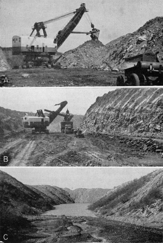
Mining methods--More than 95 percent of the Mulberry coal currently mined is produced by stripping. Formerly much of the coal was obtained from shafts or drift and slope mines (Pl. 4 C). Since 1952 only 1 shaft mine, the Guy Bunch or LaCygne Coal Company mine, half a mile east and half a mile south of LaCygne in approximately the Cen. sec. 6, T. 20 S., R. 24 E. has been in operation (Pl. 2A). This mine operates on the room and pillar system, is 36 feet deep, employs 3 men, and has a seam 36 inches thick. Two drift mines, the Ayres Coal Company and the Callahan Coal Company mines, 40 and 50 feet deep respectively, in coal 30 to 32 inches thick, located 4 to 5 miles east of Pleasanton, produced coal in 1951 but have subsequently been abandoned. Mr. Robert L. Snow operates a small strip mine about 3 miles east of Pleasanton in the NW cor. NE sec. 3, T. 25 S., R. 25 E. The 30-inch coal is mined by means of a gasoline-driven drag line having a bucket capacity of 5 cubic yards. The coal is sold as mine-run coal for $6.00 a ton. There is a second small strip mine owned by Frock in the NW cor. sec. 11, T. 23 S., R. 25 E., 3 miles east of Prescott (Pl. 2B). The only other strip-mine operation is that of the Hume-Sinclair Coal Company, producing coal in the area east of Prescott in the southeastern part of Linn County (Pls. 2C, 3). This is the only large-scale coal producer in the Mulberry coal-mining area. In order to uncover the 26-inch coal, an electric shovel equipped with a 34-cubic-yard dipper is employed to remove the 30 feet of shale overburden (Pl. 3 A). The coal is then stripped by means of a 5- to 7-cubic-yard drag line, loaded into 70-ton trucks, and transported about 2 miles east of the strippings across the State line into Missouri to the company's Tiger Coal plant where the coal is treated, sized, and prepared for distribution and sale (Pl. 3 B). The company employs 46 men in its mine.
Plate 2--Active Mulberry coal mines. A, Shaft of Guy Bunch or LaCygne Coal Company's mine, only active shaft mine in Linn County. Shaft sunk in 1949, depth 36 feet, coal averages 36 inches in thickness. Mine in the SW sec. 3, T. 19 S., R. 24 E. B, Frock strip mine, NW cor. sec. 11, T. 23 S., R. 25 E., 3 miles east of Prescott, Linn County. Coal thickness 27 inches, overburden 15 feet of shale. C, Hume-Sinclair Company's strip mine, northeast of Prescott, Linn County. Coal uncovered ready for loading. Area to left all mined since photograph was taken.
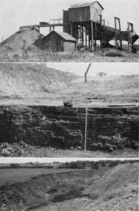
Plate 3--Phases in strip mining Mulberry coal, Hume-Sinclair Coal Company's mine northeast of Prescott, Linn County. A, First phase, removing 25 to 30 feet of shale overburden by means of electric shovel with bucket capacity of 34 to 37 yards. B, Second phase, loading coal by means of a 5- to 7-cubic yard shovel into the company's 70-ton truck for delivery to their processing plant several miles distant. C, Third phase. Coal all removed, pit abandoned to become site of one of several hundred finger-like lakes typical of the strip-mined areas of southeastern Kansas.
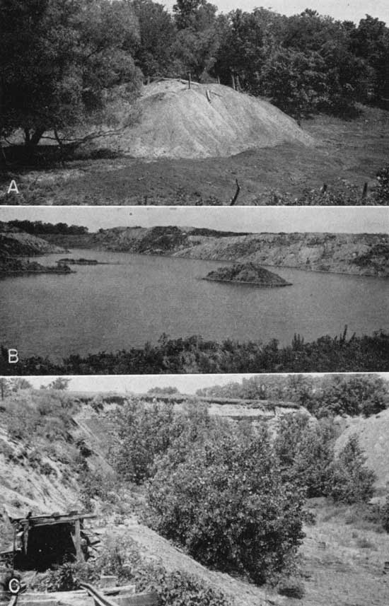
Before stripping became the dominant method of mining the coal, most of the mines were shaft mines, although some coal, where shallow, was obtained by drifting or from slope mines. A tabulation of the number of each type of Mulberry coal mines operated in Bourbon and Linn counties is presented in Table 8. The number of underground (shaft) mines indicated represents the minimum number of such mines that were in operation at one time or another. This is true because it is known that former underground mines were later engulfed and entirely obliterated by the encroaching strip mines (Pl. 4C). Vestiges of other deep mines in nonstrippable areas have long ago disappeared, and their locations are mainly forgotten or known only incidentally (Pl. 4A, 4C).
Table 8--Mulberry coal mines classified by county and type.
| County | Number of mines | |||
|---|---|---|---|---|
| Strip | Shaft | Drift or slope | Total | |
| Bourbon | 25 | 6 | 1 | 32 |
| Linn | 13 | 63 | 15 | 91 |
| Total | 38 | 69 | 16 | 123 |
Plate 4--Evidence of former coal mines. A, Typical mine dump of a former underground mine of which there are at least 85 in the Mulberry coal-mining area. Dump shown is the Coleman mine in the SW sec. 19, T. 21 S., R. 25 E., 1 mile north of Pleasanton, Linn County. B, Typical spoil banks and strip-pit lake, evidence of former surface mining. View in NW sec. 13, T. 23 S., R. 25 E., Linn County. C, Abandoned Buenes Ayres slope mine, NW sec. 36, T. 21 S., R. 25 E., Linn County. Coal 30 inches thick at depth of 40 feet. Many such mines as well as shaft mines were obliterated by more recent strip mines. Area to the right of the mine portal has been strip mined.
According to the reports of the Kansas coal mine inspectors some of the larger shaft mines formerly operated were equipped with modern machinery and were regarded as up-to-date modern mines, for their day. Many of the underground mines, however, were poorly equipped, poorly ventilated, and in general unsafe. Most of the smaller mines were worked only during the fall and winter months and then only by inexperienced men, who had no regular system of working and who in general "had but very little respect for the mining laws" (Gallagher, 1894, pp. 60-65). In most mines the room-and-pillar method of mining was employed.
Production--Complete statistics on Mulberry coal production are not available. Published records (Table 9) show that from 1872 to 1952 Linn County produced 7,686,585 tons of Mulberry coal. This quantity, however, represents a minimum cumulative total, because no production data for some of the years during the 80-year span of coal mining in the county are available. It is estimated that 9,100,000 tons of Mulberry coal has been mined in Linn County. Production statistics for Bourbon County are extremely inadequate, owing chiefly to the fact that most of the 30 or more Marmaton coal mines were very small, mined but for short periods of time and then only sporadically, and hence annual production never was reported to the coal mine inspectors. The only published data pertaining to the Mulberry coal mined in Bourbon County are for the years 1922 to 1937 (Table 10), when a total of 19,508 tons of coal was mined in the county. An inspection, however, of the areas of the mined coal aided by a knowledge of the thickness of the coal, suggests that approximately 307,000 tons of Mulberry coal has been mined in Bourbon County. The estimated tonnage of Mulberry coal produced in Linn and Bourbon counties is 9,407,000. Currently, no Mulberry coal is being mined in Bourbon County on a commercial scale. In Linn County it is the chief coal mined. In 1950 production amounted to 717,013 tons, in 1951 the tonnage was 459,210 tons, in 1952 it was 572,921 tons, and in 1953 it was 486,585 tons. Virtually all this coal is mined in one strip mine operated by the Hume-Sinclair Coal Company. Production of Mulberry coal in Linn County is summarized in Table 9.
Table 9--Mulberry coal production, Linn County, Kansas.
| Year | Production, tons* | Number of mines |
Number employed |
||
|---|---|---|---|---|---|
| Shaft | Strip | Total | |||
| 1872 | 5,256 | ||||
| 1873 | 6,786 | ||||
| 1874 | 4,716 | ||||
| 1875 | 4,752 | ||||
| 1876 | 1,980 | ||||
| 1877 | 1,872 | ||||
| 1885 | 4,556 | 1,000 | 5,556 | ||
| 1887 | 15,400 | 7,000 | 22,400 | 6 | 70 |
| 1890 | 31,494 | 31,494 | |||
| 1891 | 54,375 | 54,375 | 9 | 152 | |
| 1892 | 43,913 | 43,913 | |||
| 1,893 | 70,005 | 4,080 | 74,085 | 12 | 264 |
| 1894 | 58,476 | 58,476 | |||
| 1895 | 32,600 | 32,600 | 10 | 170 | |
| 1896 | 32,840 | 32,840 | 1 | 165 | |
| 1897 | 26,775 | 26,775 | 3 | 95 | |
| 1898 | 20,633 | 20,633 | 2 | 61 | |
| 1899 | 22,618 | 3,000 | 25,618 | 8 | 111 |
| 1900 | 35,320 | 104 | |||
| 1901 | 28,274 | 14,600 | 42,874 | 2 | 72 |
| 1902 | 3,310 | 23,507 | 26,817 | 5 | 85 |
| 1903 | 15,816 | 15,816 | 5 | 70 | |
| 1904 | 2,865 | 2,865 | 2 | 35 | |
| 1905 | 22,932 | 22,932 | 6 | 78 | |
| 1906 | 21,624 | 21,624 | 5 | 97 | |
| 1907 | 17,518 | 17,518 | 5 | 88 | |
| 1908 | 17,518 | 17,518 | 5 | 88 | |
| 1912 | 15,508 | 15,508 | 2 | 52 | |
| 1913 | 28,468 | 28,468 | 8 | 116 | |
| 1914 | 18,785 | 18,785 | 7 | 65 | |
| 1915 | 18,785 | 18,785 | 7 | 65 | |
| 1916 | 14,592 | 14,592 | 4 | 87 | |
| 1917 | 12,492 | 12,492 | |||
| 1918 | 8,739 | 8,739 | |||
| 1920 | 40,339 | 40,339 | 13 | 157 | |
| 1921 | 38,577 | 38,577 | 15 | 179 | |
| 1922 | 94,252 | 94,252 | 16 | 261 | |
| 1923 | 40,655 | 40,655 | 9 | 223 | |
| 1924 | 29,544 | 29,544 | 8 | 141 | |
| 1925 | 53,760 | 53,760 | 11 | 180 | |
| 1926 | 103,616 | 103,616 | 10 | 161 | |
| 1927 | 83,218 | 83,218 | 12 | 147 | |
| 1928 | 43,575 | 1,000 | 44,575 | 13 | 149 |
| 1929 | 11,472 | 11,472 | 8 | 71 | |
| 1930 | 5,559 | 2,655 | 8,214 | 10 | 74 |
| 1931 | 5,917 | 5,917 | 11 | 82 | |
| 1932 | 15,800 | 1,200 | 17,000 | 11 | 92 |
| 1933 | 12,326 | 12,326 | 8 | 67 | |
| 1934 | 14,349 | 325 | 14,674 | 9 | 74 |
| 1935 | 22,867 | 1,940 | 24,807 | 14 | 133 |
| 1936 | 26,587 | 10,049 | 36,636 | 18 | 136 |
| 1937 | 18,410 | 15,138 | 33,548 | 20 | 143 |
| 1938 | 19,158 | 11,137 | 30,295 | 19 | 119 |
| 1939 | 18,094 | 253,169 | 271,263 | 19 | 192 |
| 1940 | 62,506 | 698,919 | 761,425 | 22 | 232 |
| 1941 | 22,322 | 735,602 | 757,924 | 21 | 226 |
| 1942 | 22,277 | 709,513 | 731,790 | 16 | 213 |
| 1943 | 16,278 | 466,818 | 483,096 | 16 | 197 |
| 1944 | 12,691 | 1,022 | 13,713 | 13 | 46 |
| 1945 | 9,735 | 9,735 | 8 | 25 | |
| 1946 | 4,678 | 53,933 | 58,611 | 7 | 65 |
| 1947 | 5,881 | 443,606 | 449,487 | 6 | 46 |
| 1948 | 4,403 | 213,155 | 277,558 | 5 | 51 |
| 1949 | 3,874 | 152,592 | 156,466 | 8 | 59 |
| 1950 | 2,488 | 714,525 | 717,013 | 9 | 75 |
| 1951 | 957 | 458,253 | 459,210 | 6 | 65 |
| 1952 | 199 | 572,422 | 572,621 | 3 | 49 |
| 1953 | 115 | 486,470 | 486,585 | 4 | 50 |
| *Production figures compiled from the reports of the State coal mine inspectors. | |||||
Table 10--Published Mulberry coal production, Bourbon County, Kansas.
| Year | Tons |
|---|---|
| 1922 | 300 |
| 1923 | 782 |
| 1924 | 850 |
| 1925 | 4,800 |
| 1926 | 6,260 |
| 1927 | 5,420 |
| 1933 | 302 |
| 1934 | 400 |
| 1936 | 94 |
| 1937 | 300 |
| Total | 19,508 |
Reserves--In 1945 the State Geological Survey of Kansas (Abernathy, Jewett, and Schoewe, 1947) inventoried the coals of the State. [Note: The white area in T. 20 S., R. 25 E. (pl. 1) should be considered inferred reserve area.] On the basis of 1.1 specific gravity of the coal or 1,500 tons of coal per acre-foot, the proved or measured reserves of Mulberry coal totaled 62,711,000 tons, of which 54,391,000 tons was allotted to Linn County and 8,320,000 tons to Bourbon County. Subsequently the State Geological Survey adopted 1.32 as the specific gravity of the coal, or a weight of 1,800 tons per acre-foot, the standard used by the U. S. Geological Survey, Fuels Branch (Averitt and Berryhill, 1950, p. 13; Averitt, Berryhill, and Taylor, 1953, p. 23). The State Survey in conformity with other state geological surveys and the Fuels Branch of the U. S. Geological Survey reclassified its reserve coals into measured, indicated, and inferred instead of its former proved and potential coal reserves. Measured and indicated reserves correspond essentially to the Kansas proved reserves, whereas the inferred reserves are about the same as the Kansas potential reserves. As now used measured coal includes any minable coal within a radius of one-half mile from a known thickness of coal at an outcrop, in a deep well, or in a mine. Indicated coal is coal believed to be present in an area whose limits are defined by a maximum radius of 2 miles and a minimum radius of one-half mile from a known thickness of coal at an outcrop, or in a drill hole, deep well, or mine. Inferred coal is coal believed to exist more than 2 miles (but not more than 10 miles) from coal at an outcrop, or in a drill hole, deep well, or mine. The inferred (potential) coal reserves are those coals that are believed, upon broad geologic information and regional stratigraphic projection, to underlie a given area (Schoewe, 1946, pp. 40-41; Abernathy, Jewett, and Schoewe, 1947, pp. 13-14).
In calculating the measured coal reserves of the Mulberry coal, definite areas measured in square miles could be assigned to the various coal-mining districts. This could not be done for most of the indicated reserve areas because of the close spacing of the mining districts, resulting in the overlapping of reserve areas (Pl. 1). Because of the differences in the thickness of the coal, an attempt was made to approximate the indicated reserve areas (Tables 11, 14 and 29) wherever possible. Even though the individual indicated reserve areas in square miles are approximations, the combined total area of all the mining district is believed to be accurate. In computing the inferred coal reserves no attempt was made to assign any number of square miles to a mining district. These reserves are computed on a county basis, the minimum known thickness of the coal at the nearest outcrop, mine, or drill hole representing the average thickness of the coal underlying the inferred reserve area. Although all the measured and indicated Mulberry coal is restricted to Linn and Bourbon counties, the inferred coal reserves extend into Miami, Allen, and Neosho counties. Crawford County is ruled out on the basis that the Mulberry coal is known to be less than 12 inches thick in that county.
On the basis of the present studies the total of all Mulberry reserve coal amounts to 1,796,494,000 tons whereas it was estimated at 1,231,711,000 tons on incomplete data in 1946. The greatest difference in the two estimates is not so much in the total coal reserves as in their reclassification. According to the present studies, 1,372,499,000 tons is assigned to the measured and indicated coals as compared to the equivalent proved coal, which in 1946 was estimated at only 62,711,000 tons. The inferred coal amounts to 924,000,000 tons or 245,000,000 less than the 1,169,000,000 tons of potential coal calculated in 1946. Data on the Mulberry coal reserves are shown in Table 11.
Table 11--Mulberry coal reserves in Kansas as of January 1, 1954.
| County | Measured | Indicated | Inferred | All reserves | ||||
|---|---|---|---|---|---|---|---|---|
| Area, square miles |
Thousand tons |
Area, square miles |
Thousand tons |
Area, square miles |
Thousand tons |
Area, square miles |
Thousand tons |
|
| Linn | 75.89 | 172,230 | 140 | 387,264 | 239 | 390,000 | 454.89 | 949,494 |
| Bourbon | 24.68 | 49,000 | 141.46 | 264,000 | 285 | 328,000 | 451.14 | 641,000 |
| Miami | 86 | 99,000 | 86.00 | 99,000 | ||||
| Allen | 74 | 85,000 | 74.00 | 85,000 | ||||
| Neosho | 19 | 22,000 | 19.00 | 22,000 | ||||
| Total | 100.57 | 221,230 | 281.46 | 651,264 | 703 | 924,000 | 1,085.03 | 1,796,494 |
Recoverable coal--The reserve coals listed in Table 11 are original reserves or coals that are underground, and are not to be regarded as coals all of which are recoverable. At the present time it is not known precisely how much coal can be extracted or recovered from any mine or mining district in the United States. The U. S. Geological Survey, Fuels Branch, assumes a recovery of 50 percent of the coal in the ground in its calculations of the coal reserves in the United States (Averitt and Barnhill, 1950, p. 8; Averitt, Barnhill, and Taylor, 1953, pp. 12-13).
Because more than 50 percent of the coal in Kansas is normally recoverable by the stripping method, and because more than 90 percent of the Mulberry coal mined in Kansas is surface mined, the 50 percent recoverable coal assumed by the U. S. Geological Survey, Fuels Branch, is too low for Kansas. Experience in the Kansas strip coal-mining industry points to a normal recovery of 75 percent of the original coal underground. Recoverable shaft-mined coal is computed on a 50-percent recovery basis. Estimates of recoverable coal in this report apply only to measured coal reserves. These amounts for the Mulberry coal, as of January 1, 1954, are listed in Table 12. Obviously, estimates of recoverable coal must vary from time to time, depending upon annual production, economic conditions, and advances in coal technology, factors which one cannot foresee or predict for the future.
Table 12--Reeoverable measured Mulberry coal in Kansas as of January 1, 1954.
| County | Area, square miles |
Tons (short) | ||
|---|---|---|---|---|
| Strip, 75 percent recovery |
Underground 50 percent recovery |
All | ||
| Linn | 75.89 | 77,619,750 | 15,481,500 | 93,101,250 |
| Bourbon | 24.68 | 34,927,250 | 1,167,500 | 36,094,750 |
| Total | 100.57 | 112,547,000 | 16,649,000 | 129,196,000 |
Linn County ranks third in importance in coal production in Kansas and currently is the only county producing Mulberry coal commercially. Coals of two groups of rocks, the Kansas City and the Marmaton, crop out in the county and have been mined. The Thayer coal in the Chanute shale of the Kansas City group occurs in the western part of the county where at Blue Mound it was formerly mined. This coal, which is stratigraphically approximately 460 feet above the commercial Mulberry coal seam in the Bandera shale of the Marmaton group has been described previously (Schoewe, 1944). In the six coal-mining districts in Linn County, 78 deep mines and 13 Marmaton strip areas have been located and mapped (Pl. 1). The exact number of strip mines is not known, as many of the pits are today merged with others, forming a large strip-pit area. Also, the exact number of deep mines is unknown, because many a deep mine was later engulfed by the strip mines and all traces of the deep mine destroyed (Pl. 4C).
According to Brown (1896, pp. 16-17) coal was mined in Linn County as early as 1858. The place cited, a strip mine, is given as a point 2 1/2 miles north of Prescott. By 1863 coal mines were opened 3 miles north of Mound City, and in 1881 and 1884 shafts were sunk at LaCygne and Pleasanton respectively. Since that time coal has been mined more or less continuously in the eastern part of the county in shaft, slope, and surface mines. Currently (summer 1954) virtually all coal mined in the county is obtained by the stripping method in an area east of Prescott in the southeastern part of the county. In addition, two small strip mines, one about 2 miles east of Pleasanton and the other 3 miles east of Prescott (Pl. 2B), and one shaft mine about 1 mile east of LaCygne supply coal locally (Pl. 2A).
Of the coals occurring in Marmaton strata, the Mulberry seam is the only one that crops out and that has been mined in the county. The Marmaton coal-mining districts are confined to the eastern half of the county, most of the mines being situated between U. S. Highway 69 and the Kansas-Missouri state line.
The coal increases in thickness and in depth from the southeastern corner of the county to the northwest. In the southern part of the county the coal lies usually less than 35 feet beneath the surface whereas near LaCygne the coal is found at 120 feet beneath the surface. Due east of LaCygne near the Kansas-Missouri border the coal has been mined at depths ranging from 50 to 120 feet. Exception to the deeper lying coal in the northern part of the county is to be found at the only active shaft mine, which is in the SE sec. 3, T. 19 S., R. 24 E., 1 1/2 miles southeast of LaCygne. At this mine the coal is only 36 feet beneath the surface.
On the basis of published records Linn County produced 7,686,585 tons of Mulberry coal between 1872 and 1953 (Table 9). This amount, however, is a minimum figure, because records for several years are not available, and without doubt some of the farmer-miner type of production failed to be reported. Just when coal was first mined in the county is not known. First mention of coal mining in the county dates to 1858 and by 1863 coal was being mined near Mound City (Brown, 1896, pp. 16-17). Statistical data on coal production in the county do not go back beyond 1872 when, according to Gray (1878, p. 87), 270 and 292 car loads of coal were shipped from Pleasanton and Prescott respectively on the Missouri River, Fort Scott, and Gulf Railroad. A conservative estimate of Linn County coal production by mining districts is 9,100,000 tons (Table 13).
Table 13--Cumulative production of Mulberry coal in Linn County, Kansas, by coal-mining districts, to January 1, 1954.
| District | Tons |
|---|---|
| LaCygne | 132,000 |
| North Sugar Creek | 223,123 |
| Boicourt | 34,704 |
| Pleasanton | 4,000,000 |
| Mound City | 94,000 |
| Prescott | 4,608,000 |
| Mantey-Mapleton | 8,500 |
| Total | 9,100,327 |
The measured Mulberry coal reserves of Linn County comprise 7,279 square miles containing 168,129,000 tons of coal. Data on measured coal reserves by coal-mining districts are given in Table 14. Greatest present-day minable coal is found in the Pleasanton and Prescott coal-mining districts.
The indicated coal reserves underlie 140 square miles and contain an estimated 392,448,000 tons of coal. Because of the close spacing of the LaCygne, North Sugar Creek, and Boicourt mining districts (Pl. 1) the indicated reserve areas of these three mining districts overlap and hence it is not practical to consider their indicated reserve areas and tonnage separately (Table 14).
The inferred reserve area and tonnage of Linn County likewise can be considered only on the county basis. It is estimated that the inferred reserve area of Mulberry coal comprises 239 square miles underlain by at least a 17-inch coal, giving a total of 390,000,000 tons of coal (Table 14).
Table 14--Mulberry coal reserves of Linn County, Kansas, by coal-mining districts as of January 1, 1954.
| District | Measured reserves | Indicated reserves | Inferred reserves | ||||||
|---|---|---|---|---|---|---|---|---|---|
| Area, square miles |
Coal, inches |
Tons | Area, square miles |
Coal, inches |
Tons | Area, square miles |
Coal, inches |
Tons | |
| LaCygne | 7.97 | 36 | 27,408,000 | 55 | 36 | 190,080,000 | 239 | 17 | 390,000,000 |
| North Sugar Creek | 8.62 | 36 | 9,568,000 | ||||||
| Boicourt | 1.10 | 34 | 3,555,000 | ||||||
| Pleasanton | 24.74 | 28 | 63,993,000 | 35 | 28 | 94,080,000 | |||
| Prescott* | 24.36 | 24 | 51,517,000 | 32 | 24 | 73,728,000 | |||
| Mound City | 3.00 | 22 | 6,328,000 | ||||||
| Mantey-Mapleton* | 3.00 | 20 | 5,760,000 | 18 | 20 | 34,560,000 | |||
| Totals | 72.79 | 168,129,000 | 140 | 392,448,000 | 239 | 17 | 390,000,000 | ||
| *The Prescott and Mantey-Mapleton coal-mining districts extend into Bourbon County. | |||||||||
In Linn County not all the original measured Mulberry reserve coals lie within strippable depths. None of the measured coal reserves in the LaCygne and Boicourt areas can be mined by the stripping method, but other measured reserve areas range from 50 to 100 percent strippable (Table 15). Of the total 172,230,000 tons estimated as original measured reserves of Mulberry coal in the county, 39.9 percent or 68,729,600 tons is too deep to be surface mined. Of this amount, 50 percent or 34,364,550 tons is regarded as recoverable (Table 15). Of the remaining 103,500,500, tons of Mulberry coal classified as original measured reserve coal, approximately 60 percent (60.09) is within reach of the stripping shovel and on the basis of 75-percent recovery should yield 77,625,300 tons of coal. Recoverable coal data for Linn County are summarized by coal-mining districts in Table 15.
Table 15--Recoverable Mulberry measured coal of Linn County, Kansas, by coal-mining districts as of January 1, 1954.
| District | Original measured coal reserves | Recoverable measured coal, tons, January 1, 1954 |
||||
|---|---|---|---|---|---|---|
| Total | Percent within stripping depth |
Tons within stripping depths |
Tons beyond stripping depths |
Strippable 75 percent recoverable |
Underground 50 percent recoverable |
|
| LaCygne | 27,408,000 | 0 | 27,408,000 | 13,704,000 | ||
| Boicourt | 3,555,000 | 0 | 3,555,000 | 1,777,500 | ||
| North Sugar Creek | 9,568,000 | 50 | 4,784,000 | 4,784,000 | 3,588,000 | 2,392,000 |
| Pleasanton | 63,993,000 | 50 | 31,996,500 | 31,996,500 | 23,997,375 | 15,998,000 |
| Mound City | 9,861,000 | 90 | 8,874,900 | 986,100 | 6,656,175 | 493,050 |
| Prescott | 51,517,000 | 100 | 51,517,000 | 38,6379750 | ||
| Mantey-Mapleton | 6,328,000 | 100 | 6,328,000 | 4,746,000 | ||
| Totals | 172,230,000 | 103,500,500 | 68,729,600 | 77,625,300 | 34,364,550 | |
The LaCygne coal-mining district centers around LaCygne, primarily in, sec. 32, T. 19 S., R. 24 E. and secs. 2, 3, 4, 13, and 15, T. 20 S., R. 24 E. (Pl. 1). All the mines are shaft mines; only one is active today. Coal seemingly was mined in the district as early as 1873 for in that year one car load of coal was shipped on the Missouri River, Fort Scott, and Gulf Railroad from LaCygne. In 1874 and 1875 two and five car loads respectively of coal were shipped (Gray, 1878, p. 87) on that same railroad. Just where the coal came from is not known but it is reasonable to assume that the coal wag mined in close proximity to LaCygne. Coal mining at LaCygne was in earnest in 1881. In that year a group of citizens of LaCygne raised $1,000 and gave it to a Mr. George Morely for the purpose of prospecting for coal at LaCygne and vicinity. Mr. Morely was successful in finding a 36-inch seam of coal at a depth of 120 feet about half a mile north of the center of the town in the NE sec. 32, T. 19 S., R. 24 E. Immediately another stock company was organized, which was successful in finding coal in the southern part of LaCygne in sec. 4, T. 20 S., R. 24 E. (Andreas, 1883, p. 1113). In 1882 there were two shafts at LaCygne (Sims, 1883, p. 311) whose reported depths were 110 feet and in which the coal measured 3 feet thick.
Field evidence of 12 shaft mines was found in the LaCygne coal-mining district (Table 16). Just how many shafts have been sunk and operated is not known for certain. Reports published by Kansas coal mine inspectors reveal the names of 23 mines. It is certain that some of the mines were operated under different names during the years of their activity, but it is impossible to tell which mines were thus operated, because specific locations are not reported. Furthermore, traces of former mines may be obliterated entirely or may be so inconspicuous that the mine locations would never be recognized without the aid and knowledge of some local resident. The only active deep mine in Linn County is the Guy Bunch mine in the SE sec. 3, T. 20 S., R. 24 E., about three-quarters of a mile east and half a mile south of the east edge of LaCygne (Pl. 2A). This shaft was sunk in 1949 to a depth of 36 feet and found coal 36 to 48 inches thick.
Table 16--Location, classification by type of mine, and other data on coal mines in the LaCygne coal-mining district, Linn County, Kansas.
| Name | Location | Type | Depth to coal, feet |
Thickness of coal, inches |
Status |
|---|---|---|---|---|---|
| Hollman | NE 32-19-24E | Shaft | 120 | 36 | Abandoned |
| Black Diamond | |||||
| Morley? | |||||
| Warren Lacy | SE 32-19-24E | Shaft | 110 | 24 | Abandoned |
| Warren Lacy | SE 32-19-24E | Shaft | 110 | 24 | Abandoned |
| SW 34-19-24E | Shaft | All evidence gone | |||
| J. Murray | NE 4-20-24E | Shaft | |||
| Gowing | SW 4-20-24E | Shaft | Abandoned | ||
| Redpath? | NE 3-20-24E | Shaft | Abandoned | ||
| Martin | NE 3-20-24E | Shaft | |||
| Guy Bunch | SE 3-20-24E | Shaft | 36 | 36-48 | Active |
| Hyromec | Cen. 2-20-24E | Shaft | 100 | 30-48 | Abandoned |
| Kaw Valley | SE 15-20-24E | Shaft | 60 | 40 | Abandoned |
| Shelton | SW 13-20-24E | Shaft | Abandoned |
The coal in the LaCygne mining district is 24 to 48 inches thick and occurs 36 to 120 feet below the ground. The overburden consists mainly of shale. A limestone roof was reported above the coal in the Bunch mine east of LaCygne. Data summarizing the coal mines of the LaCygne coal-mining district are presented in Table 16.
Proxinmte analysis--The one sample of coal collected in the LaCygne coal-mining district was taken from the only active mine in the district, the Bunch or LaCygne Coal Company mine in the SE sec. 3, T. 20 S., R. 24 E. The proximate analysis of the coal is presented in Table 4.
Production--Coal seemingly was mined in the LaCygne coal-mining district as early as 1873 (Gray, 1878, p. 87) and according to the reports of the state coal mine inspectors production has continued more or less continuously to the present time (Table 17). On the basis of published records 101,363 tons of coal is estimated to have been mined in the years for which data are lacking, making thus a grand total of 132,000 tons of coal produced in the LaCygne mining district.
Table 17--Mulberry coal production of the LaCygne coal-mining district Linn County, Kansas.
| Year | Tons |
|---|---|
| 1873 | 18 |
| 1874 | 36 |
| 1875 | 90 |
| 1887 | 2,080 |
| 1893 | 482 |
| 1899 | 2,000 |
| 1902 | 750 |
| 1903 | 800 |
| 1913 | 2,300 |
| 1914 | 2,325 |
| 1915 | 2,325 |
| 1920 | 7,154 |
| 1921 | 6,004 |
| 1922 | 8,019 |
| 1923 | 2,465 |
| 1924 | 2,172 |
| 1925 | 4,273 |
| 1926 | 4,943 |
| 1927 | 5,426 |
| 1928 | 7,233 |
| 1929 | 1,868 |
| 1930 | 200 |
| 1931 | 1,480 |
| 1932 | 7,507 |
| 1933 | 3,479 |
| 1934 | 3,314 |
| 1935 | 3,294 |
| 1936 | 3,044 |
| 1937 | 2,878 |
| 1938 | 2,635 |
| 1939 | 2,247 |
| 1940 | 802 |
| 1941 | 1,477 |
| 1942 | 1,170 |
| 1943 | 552 |
| 1944 | 808 |
| 1945 | 1,598 |
| 1946 | 74 |
| 1949 | 251 |
| 1950 | 627 |
| 1951 | 649 |
| 1952 | 199 |
| 1953 | 115 |
| Total reported production |
101,363 |
| Estimated for years for which no production is reported |
30,600 |
| Total production | 131,963 |
Reserves--The LaCygne coal-mining district contains 7.97 square miles of measured coal-reserve land, of which 6.45 square miles is assigned to the district proper centering around LaCygne and 1.52 square miles to the two small isolated areas 3 miles South of LaCygne (Pl. 1). The coal for the entire district averages 36 inches in thickness. On this basis 27,540,000 tons of Mulberry coal originally underlay the district. Production for the district is calculated at 132,000 tons, leaving thus still underground 27,408,000 tons of minable coal, of which at least 50 percent is recoverable (Table 14).
Because of the overlapping of reserve areas of relatively closely spaced mining districts it is not practical to estimate indicated and inferred coal reserve lands and coal tonnage separately. These are best calculated for the county as a unit and for the purpose of this report are thus considered.
The Mound City coal-mining district centers around Mound City, the county seat of Linn County. Coal was formerly mined in secs. 31, 32, and 33, T. 21 S., R. 24 E., and in secs. 5 and 8, T. 22 S., R. 24 E. The district, however, includes portions of secs. 28, 29, and 30, T. 21 S., R. 24 E., and parts of secs. 4, 6, 7, 9, 17, and 18, T. 22 S., R. 24 E. (Pl. 1). Coal mines were opened in this district as early as 1863 at a point given as 3 miles north of Mound City (Brown, 1896, p. 16). These early mines, mainly drift mines and one strip, were in secs. 31, 32, and 33, T. 21 S., R. 24 E. The coal had a thickness of 17 inches and was mined by the room-and-pillar method. The largest operation, however, a strip mine, abandoned since 1950, is in secs. 5 and 8, T. 22 S., R. 24 E., approximately three-fourths mile northeast of Mound City. The coal where mined averaged 17 inches thick. Greater thickness of the coal was observed at several places where the coal crops out. On the north side of the Mound City strip pit in the SE sec. 5, T. 22 S., R. 24 E., at a place just above water level of a small creek flowing along the side of the northernmost spoil bank in the timber, the coal measured 18 to 22 inches thick. Jewett (1945, p. 77) also observed the coal in the Mound City strip-pit mine in the NEI/4 sec. 8, T. 22 S., R. 24 E. to be 18 inches thick. In 1884 coal 22 inches thick and 6 feet below the surface was mined at Mound City (Sims, 1885, p. 226). Coal 22 inches thick and less than 10 feet beneath the surface crops out along a small creek in the western part of sec. 33, T. 21 S., R. 24 E.. This coal is underlain by 3 feet of clay shale, which is resting on the Pawnee limestone, of which 18 to 24 inches is exposed. Other outcrops of coal measuring 20 inches thick were observed in the NE sec. 32, T. 21 S., R. 24 E. Jewett (1945, p. 76) found the coal to be about 1 foot thick near the Cen. W. line sec. 5, T. 22 S., R. 24 E., along the banks of Little Sugar Creek. The coal lies 3 feet above the Laberdie limestone member of the Pawnee limestone formation. As the coal is the uppermost unit exposed, its true thickness is not necessarily indicated by the 12 inches observed and measured.
Production--The amount of coal produced in the Mound City coal-mining district is not known. The strip mine just northeast of Mound City covers approximately 35 acres. On the basis that thickness of the coal underlying the area averages 17 inches, 89,250 tons of Mulberry coal has been extracted from this pit. Published data for this strip-pit mine are available for the years 1935 to 1950 and total 25,306 tons of coal (Table 18). All State coal mine inspector reports previous to 1935 fail to mention the Mound City strip mine but do list production for strip mines for the entire county. Between 1935 and 1950 at least five different operators worked the Mound City strip mine. No data are available in regard to coal production for the mines in the northern part of the area, which ceased operations about 1894 (Fred Stuart, present owner of coal mine lands, personal communication). It is doubtful whether more than 5,000 tons of coal was taken from these small drift mines during their operating years. An estimated production of 94,000 tons of coal is assigned to the Mound City coal-mining district.
Table 18--Published coal production, Mound City strip mine, Linn County, Kansas.
| Year | Tons |
|---|---|
| 1935 | 1,940 |
| 1936 | 4,878 |
| 1937 | 5,850 |
| 1938 | 7,646 |
| 1939 | 200 |
| 1940 | 529 |
| 1941 | 200 |
| 1942 | 979 |
| 1943 | 140 |
| 1944-47 | 0 |
| 1948 | 1,409 |
| 1949 | 1,200 |
| 1950 | 335 (first half of year) |
| Total | 25,306 |
Reserves--On the basis of a drill hole in the NW cor. SW sec. 4, T. 22 S., R. 24 E., and another one in Mound City approximately in the Cen. SE sec. 7, T. 22 S., R. 24 E., the coal outcrops in secs. 32 and 33, T. 21 S., R. 24 E., the drift mines in sec. 32, T. 21 S., R. 24 E., and the strip mines in secs. 31 and 33, T. 21 S., R. 24 E. and secs. 5 and 8, T. 22 S., R. 24 E., it is estimated that an area of 6.1 square miles originally was underlain by Mulberry coal 12 to 22 inches thick. On the basis of 17 inches as the average thickness, the amount of coal originally present in the district was 9,955,200 tons. Subtraction from this amount of 94,000 tons estimated to have been mined leaves 9,861,200 tons of unmined measured coal reserves. What percent of this amount represents recoverable coal depends upon the method employed to extract the coal if production is resumed. Except for the vicinity of Mound City, where the coal lies at a depth of 110 feet, the coal is within present day stripping limits almost everywhere and in most places within 25 feet beneath the surface.
Indicated and inferred reserves cannot well be calculated solely for the Mound City coal-mining district as such reserve lands overlap those of other near-by coal-mining districts. Such reserves are best estimated for the county as a whole. Coal reserves for the Mound City coal-mining district are tabulated in Table 14.
The Boicourt coal-mining district centers around Boicourt or Barnard as it was formerly known. Boicourt is in sec. 35, T. 20 S., R. 24 E., a short distance south of Marais des Cygnes River and approximately half way between LaCygne on the north and Pleasanton on the south. Evidence was found of only two shaft mines, now abandoned, in the district, one at the southeast edge of town and the other, the Bradley-Vernon mine, approximately half a mile south of the first mine. The Bradley-Vernon mine was one of the most important shaft mines in Linn County. It is reported to have been 90 to 95 feet deep and had two openings. In 1891 (Stewart, 1892, p. 36) the mine was equipped with modern machinery and employed 25 to 50 men. The coal measured 34 to 36 inches in thickness, was of good quality, and had a very small sulfur content. The coal was overlain by gray slate and underlain by soft fire clay. Mining was done by the room-and-pillar method. The mine was located on the Kansas City, Fort Scott, and Gulf Railroad. Most of the coal was shipped by rail, some of it was loaded into locomotive chutes, some was sold to local trade, and some was used at the mines (Brown, 1896, p. 78). The shaft was opened in 1891 (Stewart, 1892, p. 36; Brown, 1896, p. 17) and was closed down because of low coal prices in 1895 (McGrath, 1898, p. 72). Seemingly other mines were in operation in the Boicourt district before the Bradley-Vernon mine shaft was sunk. According to Mudge (Gray, 1878, p. 87) coal was mined at Boicourt as early as 1872, for from 1873 to 1877, a total of 167 cars of coal of 18 tons capacity each was shipped from Boicourt on the Missouri River, Fort Scott, and Gulf Railroad. Gray (1875, p. 319) mentions the sinking of a mine shaft to a depth of 90 feet and encountering a coal seam measuring 40 inches in thickness. Traces of these early mines are no longer to be seen unless the mines were located at the sites of the more recent mines of the 1890's and 1910's.
Production--Except for the reference (Gray, 1878, p. 87) to the 167 cars of coal shipped from Boicourt between 1873 and 1877 the only coal production figures published by the Kansas coal mine inspectors are those shown in Table 19. A minimum production, therefore, of 31,698 tons plus 3,006 tons shipped between 1873-1877 or 34,704 tons of coal may be assigned to the Boicourt mining district.
Table 19--Coal production in the Boicourt coal-mining district, Linn County, Kansas.
| Year | Bradley-Vernon mine, tons |
Boicourt Coal Co. mine, tons |
Total |
|---|---|---|---|
| 1893 | 18,873 | 18,873 | |
| 1894 | |||
| 1895 | 11,037 | 11,037 | |
| 1906 | 1,150 | 1,150 | |
| 1913 | 208 | 208 | |
| 1914 | 215 | 215 | |
| 1915 | 215 | 215 | |
| Total | 29,910 | 1,788 | 31,698 |
Reserves--The measured coal reserve area of the Boicourt coal-mining district comprises 1.1 square miles. On the basis of 34 inches as the average thickness of the coal seam, 3,590,400 tons of coal originally underlay the district. Subtracting from this amount approximately 35,000 tons known to have been mined leaves thus a measured reserve of 3,555,400 tons of coal (Table 14). As for the other mining districts in Linn County, the indicated and inferred coal reserves are best considered in relation to the county as a whole.
The North Sugar Creek coal-mining district is along North Sugar Creek in the northeastern part of Linn County 5 to 8 miles east and southeast of LaCygne. The mines are all in R. 25 E., 10 mines being in T. 19 S., and 16 in T. 20 S. All the mines except 2 small strip pits are underground mines, none of which was in operation in 1953. As in the other mining districts, some of the mines changed ownership and consequently changed names. In most cases it is impossible to tell from the published records which mines operated under more than one name. Reports of the State coal mine inspectors record 33 mines, although field evidence for only 26 mines is to be found in the district. Data pertaining to the mines of this district are given in Table 20.
Table 20--Mulberry coal mines, North Sugar Creek coal-mining district, Linn County, Kansas.
| Name | Location | Depth to coal, feet |
Thickness of coal, inches |
Type of mine |
|---|---|---|---|---|
| Jarred | NW 35-19-25E | 86 | Underground | |
| Henry McNabb | NW cor. SW 35-19-25E | 72 | Underground | |
| Vantyle | NW SW SW 35-19-25E | 90 | 36-42 | Underground |
| Vantyle | SW cor. SW 35-19-25E | 65 | 36-42 | Underground |
| Max Cerise Cox | NW 34-19-25E | Underground | ||
| C. Good | SW cor. 34-19-25E | 40 | Underground | |
| Pinkert-Hall | SE SW 34-19-25E | Underground | ||
| N. line SE 34-19-25E | Underground | |||
| N. line SE 34-19-25E | Underground | |||
| NE cor. SW 33-19-25E | Underground | |||
| Ben Good | NW. cor. 2-20-25E | Underground | ||
| Hall-Charlie Good | SE cor. NW NW 2-20-25E | 50 | 48 | Underground |
| King | NE cor. 3-20-25E | 60-65 | Underground | |
| Berry-Vantyle | NE cor. NW 3-20-25E | Underground | ||
| NW cor. 3-20-25E | Underground | |||
| E. line NW 2-20-25E | Underground | |||
| SE cor. NW SW 8-20-25E | Underground | |||
| NE cor. NE SW 8-20-25E | Underground | |||
| Schirard | SE cor. NE SW 8-20-25E | Underground | ||
| S. line NE SW 8-20-25E | Underground | |||
| NE cor. SW SW 8-20-25E | Underground | |||
| NW cor. NW SE 8-20-25E | Underground | |||
| NE cor. NW SE 8-20-25E | Underground | |||
| Rucker | SW 9-20-25E | 15 | Strip | |
| Gage | NW cor. 16-20-25E | 15 | Underground | |
| W. line SW 16-20-25E | Underground |
The coal lies at depths ranging from 15 to 90 feet and is 3 to 4 feet thick. The two small strip mines reported are farmyard pits no more than 200 feet long and less than 50 feet wide with overburdens of about 15 feet. Because of the location close to drainageways, the coal is of poor quality and consequently was not exploited to any appreciable extent. The last mine in the district to operate was the Shirley slope in the SE cor. NE SW sec. 18, T. 22 S., R. 25 E. This mine ceased mining coal at the close of the 1951 mining season. All the mines served local trade.
Production--Production data for the district are incomplete. The earliest record of coal production found for the district is for the year 1887, the last 1945, and for many intervening years no data are available. The total amount of coal produced for the district (Table 21) is 171,123 tons. This amount represents the minimum tonnage, as it is known that coal was mined as late as 1951.
Based on the production figures for which data are available (Table 21) production of 52,000 tons of coal is estimated for the unrecorded years, which, added to the recorded 171,123 tons, gives approximately 223,000 tons as the coal production of the North Sugar Creek coal-mining district.
Table 21--Published coal production for the North Sugar Creek coal-mining district, Linn County, Kansas.
| Year | Tons |
|---|---|
| 1887 | 6,320 |
| 1890 | 2,954 |
| 1891 | 3,794 |
| 1893 | 4,415 |
| 1895 | 4,200 |
| 1899 | 3,500 |
| 1901 | 2,674 |
| 1902 | 1,480 |
| 1903 | 1,700 |
| 1920 | 1,754 |
| 1921 | 1,697 |
| 1922 | 5,541 |
| 1925 | 270 |
| 1926 | 3,931 |
| 1927 | 23,089 |
| 1928 | 12,938 |
| 1929 | 3,557 |
| 1930 | 3,664 |
| 1931 | 1,640 |
| 1932 | 5,378 |
| 1933 | 3,476 |
| 1934 | 7,528 |
| 1935 | 9,081 |
| 1936 | 9,934 |
| 1937 | 6,336 |
| 1938 | 8,163 |
| 1939 | 6,521 |
| 1940 | 7,643 |
| 1941 | 5,019 |
| 1942 | 5,644 |
| 1943 | 4,419 |
| 1944 | 2,475 |
| 1945 | 388 |
| Total | 171,123 |
Reserves--The measured reserve coal area of the district is 8.62 square miles. The coal averages 36 inches in thickness. The estimated original coal tonnage therefore amounts to 29,790,720 tons of which 223,000 tons has been mined, leaving thus underground 29,567,720 tons (Table 14). Inasmuch as most of the coal in the district lies 60 or more feet beneath the surface, the practical lower limit of present-day strip mining, most of the coal if mined in the near future will be produced in shaft mines. At least 50 percent of this coal under present-day mining methods is recoverable, or approximately 14.7 million tons, which if valued at the average 1953 price amounts to more than $59,000,000.
The Pleasanton coal-mining district centers around Pleasanton and Mine Creek and extends as far east as the Kansas-Missouri state line (Pl. 1). In general the district lies south of Marais des Cygnes River but includes one strip pit and two shaft mines north of the river adjacent to the state line in sec. 1, T. 21 S., R. 25 E., slightly more than 3 miles east of Trading Post. In the district are surface mines, now all abandoned, comparable in size to those in the Prescott mining district to the south. This district differs from its neighbor to the south, however, in that formerly coal was mined extensively in numerous (30 or more) shaft mines (Pl. 4A). Traces of still other known shaft mines have been obliterated, particularly in the area east of Mine Creek, by the encroachment of the open-pit mines.
The coal where formerly mined in the district lies 12 to 90 feet below the surface and ranges in thickness from 26 to 36 inches. Many of the shaft mines had railroad connections. The strip-pit mines parallel both sides of Mine Creek and are of long linear pattern with numerous irregularities following tributary valleys, especially on the east side of Mine Creek. A list of the known coal mines in the district is presented in Table 22. The reports of the Kansas coal mine inspectors show that 86 companies have operated in the district, of which 9 were strip-mining companies. The exact number of mines that existed in the district is not known, as no definite locations of the mines have been recorded in the published reports. It is known that 4 mines were each operated by at least 8 companies. How many more changed ownership is not determinable from published data; no doubt there were others. On the basis of field evidence there are 40 underground mines and 8 strip-pit areas mappable (Pl. 1). Some of the early shaft mines undoubtedly were engulfed by stripping operations and their locations thereby lost. The locations of many of the mapped mines were spotted in the field with the aid of the late Mr. John Pelligreno, former Kansas coal-mine inspector, who also supplied the names of some of the mines.
Table 22--Mulberry coal mines, Pleasanton coal-mining district, Linn County, Kansas.
| Name | Location | Depth, feet |
Thickness of coal, inches |
|---|---|---|---|
| Underground mines | |||
| Iowa-Green Valley | SE cor. 12-21-24E | 120 | 36 |
| Calvin | SW 1-21-25E | ||
| NE cor. SW 1-21-25E | |||
| Coleman | W. line SE 19-21-25E | ||
| S. line SE 19-21-25E | |||
| Gremel slope | Cen. NW 25-21-25E | 50 | 34 |
| Callahan slope | Cen. SW 25-21-25E | ||
| Hudson | S. line W2 SW 25-21-25E | ||
| Galbraith | S. line E2 SW 25-21-25E | 45 | 32 |
| Robinson | NW cor. SW 26-21-25E | ||
| E2 SW 26-21-25E | |||
| Douglas | NE cor. SE 26-21-25E | 68 | 33 |
| Seright-Deaddog- Walthour slope |
SE cor. NW 27-21-25E | 60 | 34 |
| Jewett 1 | SW cor. NW 28-21-25E | ||
| Jewett 2 | S. line NW 28-21-25E | ||
| Bishop-Valentine | Cen. 28-21-25E | ||
| Menghinni | S. line NE 28-21-25E | 60 | 30 |
| Linn County-Valentine | N. line SE 28-21-25E | 50 | 30 |
| S. line 28-21-25E | 42 | 30 | |
| Palooka-Pleasanton Coal & Mining Co. |
Cen. 29-21-25E | 92 | 26 |
| Pleasanton | NW cor. 30-21-25E | 85 | 28 |
| SW cor. NW 30-21-25E | |||
| N. line NE 33-21-25E | |||
| NE NE 33-21-25E | |||
| SW cor. SE 34-21-25E | |||
| Kelley | S. cen. NE 35-21-25E | ||
| Callahan slope | S. line E2 SW 35-21 25E | 50 | 32 |
| S. line W2 SW 35-21-25E | |||
| E. line NW 36-21-25E | |||
| Buenes Ayres slope | S. line NW 36-21-25E | 40 | 30 |
| Tierney | NW cor. 2-22-25E | 23 | 32 |
| N. line NW NE 3-22-25E | |||
| N. line NW NE 3-22-25E | |||
| NW NE 3-22-25E | |||
| NW NE 3-22-25E | |||
| NW SW 3-22-25E | |||
| N. line NE NW 3-22-25E | |||
| N. line NE NW 3-22-25E | |||
| SW NE NW 3-22-25E | |||
| Endacott slope | SW NE NW 3-22-25E | 17 | 30 |
| Strip mines | |||
| E2 14-21-25E | |||
| N2 23-21-25E | |||
| Cen. SW 14-21-25E | |||
| E. line SW 14-21-25E | |||
| W. line SW 23-21-25E | |||
| NE 27-21-25E | |||
| N. line SW 27-21-25E | |||
| E. line SE 28-21-25E | |||
| E2 33-21-25E | |||
| Hume-Sinclair | W2 25-21-25E | 15 | 30 |
| E2 and E. line SW 26-21-25E | 15 | 30 | |
| NW 36-21-25E | 15 | 30 | |
| 35-21-25E | |||
| SE 35-21-25E | |||
| Snow | SE cor. SW 34-21-25E | ||
| Snow (active) | NW cor. NE 3-22-25E | 15 | 30 |
| Frock (active) | Cen. NW 3-22-25E | 10 | 30 |
| NW cor. NE 4-22-25E | 10 | ||
Production--The earliest record of coal production for the Pleasanton district is for the year 1872, when 270 cars of coal (4,860 tons) were shipped from Pleasanton on the Missouri River, Fort Scott, and Gulf Railroad. Presumably coal was mined in the district at an earlier date. Between 1872 and 1877 a total of 574 cars (10,332 tons) of coal were shipped from Pleasanton (Mudge, 1878, p. 87). From published records and estimates (Table 23) a total of 4,000,000 tons of coal has been mined in the Pleasanton coal-mining district.
Table 23--Published Mulberry coal production, Pleasanton coal-mining district, Linn County, Kansas.
| Year | Tons |
|---|---|
| 1872-1877 | 10,332 |
| 1887 | 1,063 |
| 1891 | 14,112 |
| 1893 | 14,474 |
| 1895 | 13,811 |
| 1896 | 32,840 |
| 1897 | 26,775 |
| 1898 | 20,633 |
| 1899 | 17,118 |
| 1901 | 25,600 |
| 1902 | 24,587 |
| 1903 | 13,316 |
| 1904 | 2,865 |
| 1905 | 21,975 |
| 1906 | 21,624 |
| 1907 | 17,518 |
| 1908 | 17,518 |
| 1912 | 15,508 |
| 1913 | 25,960 |
| 1914 | 16,245 |
| 1915 | 16,145 |
| 1916 | 9,581 |
| 1920 | 31,432 |
| 1921 | 30,874 |
| 1922 | 66,184 |
| 1923 | 27,608 |
| 1924 | 25,772 |
| 1925 | 48,791 |
| 1926 | 93,151 |
| 1927 | 53,703 |
| 1928 | 23,254 |
| 1929 | 4,747 |
| 1930 | 1,694 |
| 1931 | 2,297 |
| 1932 | 2,727 |
| 1933 | 2,535 |
| 1934 | 3,832 |
| 1935 | 7,597 |
| 1936 | 17,358 |
| 1937 | 7,341 |
| 1938 | 9,105 |
| 1939 | 253,482 |
| 1940 | 748,427 |
| 1941 | 749,596 |
| 1942 | 719,539 |
| 1943 | 13,240 |
| 1944 | 9,398 |
| 1945 | 7,749 |
| 1946 | 6,445 |
| 1947 | 445,097 |
| 1948 | 4,403 |
| 1949 | 4,020 |
| 1950 | 2,776 |
| 1951 | 1,237 |
| 1952 | 486 |
| 1953 | 494 |
| Total | 3,808,989 |
Coal is being mined in the district at present only at two small strip mines in the northern part of sec. 3, T. 22 S., R. 25 E. The coal is 30 inches thick and is overlain by 10 to 15 feet of shale. A small drag line is used to remove the overburden and the coal is then pried loose by hand, loaded onto trucks, and sold as mine-run coal at $6.00 a ton.
Reserves--The measured coal reserve area of the Pleasanton coal-mining district consists of approximately 1 square mile east of Trading Post and north of Marais des Cygnes River, 2 square miles southwest of Trading Post or north of Pleasanton adjacent to Marais des Cygnes River on the south, and 20 square miles between Pleasanton and vicinity eastward to the state line. The measured original coal reserves for the district are estimated at 68,000,000 tons distributed by subdivisions as shown in Table 24. Subtracting from this amount approximately 4,000,000 tons estimated to have been mined leaves thus still in the ground 64,000,000 tons of measured original coal. Indicated and inferred coal reserves are considered in connection with the total coal reserves for the county (Table 14).
Table 24--Measured coal reserves of the Pleasanton coal-mining district, Linn County, Kansas.
| Subdivision | Area, square miles |
Thickness of coal, inches |
Original coal, tons |
|---|---|---|---|
| Trading Post, east | 1.02 | 30 | 2,937,600 |
| Trading Post, southwest | 1.7 | 36 | 5,875,200 |
| Pleasanton-state line | 22.02 | 28 | 59,179,760 |
| Total | 67,992,560 | ||
| Production | 4,400,000 | ||
| Measured coal reserves, January 1, 1954 |
63,992,560 |
The Prescott coal-mining district is in the southeastern part of Linn County in T. 23 S., Rs. 24 and 25 E. and extends southward into Bourbon County in secs. 19, 20, 29, and 30, T. 23 S., R. 25 E. and is the only district in which coal is being mined on an extensive and commercial scale. Thirty surface and five underground mines are known to have operated in the district (Table 25). Traces of other mines, if any existed, have been obliterated, owing to the lateral expansion of the larger mines. Where mined, past and present, the coal lies 12 to 30 feet beneath the surface and ranges in thickness from 20 to 32 inches, averaging 28 inches. Of the five shaft mines in the district, four are indicated by their dump heaps (Pl. 4A). The fifth shaft mine, the Kite mine, about a mile southeast of Prescott in the SE sec. 8, T. 23 S., R. 25 E. is known only from information received from the former owner's son. The mine was 40 feet deep and the coal 30 inches thick. The deepest underground mine in the district is in the NW cor. sec. 5, T. 23 S., R. 25 E., 1 mile due north of Prescott along U. S. Highway 69. It is 70 feet deep and the coal is 18 to 24 inches thick. The McIntire shaft, 3 miles west of Prescott in the SW sec. 11, T. 23 S., R. 24 E., is 41 feet deep and the coal is 28 to 30 inches thick. The thickness of the overburden and thickness of coal of the other three known shaft mines are not known.
Table 25--Mulberry coal mines, Prescott coal-mining district, Linn and Bourbon counties, Kansas.
| Name | Location | County | Depth, feet |
Thickness of coal, inches |
Type of mine |
|---|---|---|---|---|---|
| McIntire | SW 11-23-24E | Linn | 41 | 24-30 | Underground |
| Brick slope | SW cor. SW 4-23-25E | Linn | Underground | ||
| NW cor. 5-23-25E | Linn | 70 | 24 | Underground | |
| Kite | SE 8-23-25E | Linn | 40 | 30 | Underground |
| Kealey | NE 19-23-25E | Bourbon | Underground | ||
| Hume-Sinclair | W2 25-22-25E | Linn | Strip | ||
| Hume-Sinclair | S2 26-22-25E | Linn | Strip | ||
| Hume-Sinclair | E2 NE and S2 34-22-25E | Linn | 29 | 24 | Strip |
| Hume-Sinclair | S2 33-22-25E | Linn | 25 | 24 | Strip |
| Hume-Sinclair | E2 NE and S2 34-22-25E | Linn | Strip | ||
| Hume-Sinclair | W. line and N2 35-22-25E | Linn | Strip | ||
| Hume-Sinclair | NW 36-22-25E | Linn | Strip | ||
| Hume-Sinclair | N. line NW 1-23-25E | Linn | Strip | ||
| Hume-Sinclair | NW and S2 2-23-25E | Linn | Strip | ||
| Hume-Sinclair | NE and S2 3-23-25E | Linn | 25 | 21 | Strip |
| Hume-Sinclair | E2 11-23-25E | Linn | Strip | ||
| Hume-Sinclair | NW 13-23-25E | Linn | Strip | ||
| Hume-Sinclair | NE 14-23-25E | Linn | Strip | ||
| Frock | NW cor. 11-23-25E | Linn | 1-5 | 27 | Strip |
| Lapsley | W. line SW 6-23-25E | Linn | Strip | ||
| SW cor. 6-23-25E | Linn | Strip | |||
| Hume-Sinclair | N2 NE 5-23-25E | Linn | 25 | 20 | Strip |
| S. line NEI/4 5-23-25E | Linn | Strip | |||
| SE 5-23-25E | Linn | 25-28 | 20-22 | Strip | |
| NW cor. SW 4-23-25E | Linn | Strip | |||
| SW 4-23-25E | Linn | Strip | |||
| S. line 3-23-25E | Linn | Strip | |||
| N. line SW 11-23-25E | Linn | Strip | |||
| S. line SW 11-23-25E | Linn | Strip | |||
| W. line SE 10-23-25E | Linn | Strip | |||
| N. line SE 9-23-25E | Linn | Strip | |||
| SW cor. 7-23-25E | Linn | Strip | |||
| NE cor. NW 15-23-25E | Linn | Strip | |||
| E. cen. NE 18-23-25E | Linn | Strip | |||
| NE 19-23-25E | Bourbon | Strip | |||
| Shirley | SW 20-23-25E | Bourbon | Strip | ||
| E. line 1-23-24E | Bourbon | Strip | |||
| SE cor. 10-23-24E | Bourbon | Strip | |||
| SW cor. 11-23-24E | Bourbon | 18 | 5 | Strip | |
| E. line SW 11-23-24E | Bourbon | 5 | Strip | ||
| W. line SE 11-23-24E | Bourbon | 5 | Strip | ||
| Cen. SE 11-23-24E | Bourbon | Strip | |||
| NE cor. 12-23-24E | Bourbon | Strip | |||
| NF, cor. 12-23-24E | Bourbon | Strip | |||
| NE cor. 13-23-24E | Bourbon | Strip | |||
| NE cor. 14-23-24E | Bourbon | Strip |
The only commercial coal mine in the district is between Prescott and the Kansas-Missouri state line and is being operated by the Hume-Sinclair coal-mining company, whose plant is in Missouri less than a quarter of a mile east of the state line. On January 1, 1954, the company's big electric shovel was removing the overburden in sec. 5, T. 23 S., R. 25 E., only about 1 mile northeast of Prescott. The mined coal is 20 to 24 inches thick and is overlain by 25 to 38 feet of shale. Proximate analyses of the coal are shown in Tables 4 and 5. A small strip mine (Pl. 2B) operated by Mr. Frock is located in the NW cor. sec. 11, T. 23 S., R. 25 E., and supplies coal for the local trade.
Production--The earliest record of coal mining in Linn County is for the year 1858 when coal is reported to have been stripped at a point 2 1/2 miles north of Prescott (Brown, 1896, p. 16). The first recorded production for the Prescott coal-mining district is for the years 1872-1877 when 929 cars of coal of 18 tons capacity each (16,722 tons) were shipped from Prescott, then known as Coal Center, on the Missouri River, Fort Scott, and Gulf Railroad (Mudge, 1878, p. 87). Complete data on coal production for the district are not available. Most of the mines until about 1948 were small affairs, 1 to 5 acres in size, and local or noncommercial mines whose production seemingly was not reported to the State coal mine inspectors or at least not recorded by them in their reports. It is estimated that coal in the district has been taken from 2 square miles, which, if the coal averaged 24 inches in thickness, would yield 4,608,000 tons of coal. Published coal production data are presented in Table 26. It will be noted from the table that coal production in the district on an extensive scale did not start until 1948 and that since 1950 only two mines have produced coal.
Table 26--Published Mulberry coal production data for the Prescott coal-mining district, Linn County, Kansas.
| Year | Number of mines |
Tons |
|---|---|---|
| 1872-1877 | 16,722 | |
| 1940 | 3 | 3,280 |
| 1941 | 1 | 2,032 |
| 1942 | 1 | 1,740 |
| 1943 | 1 | 1,637 |
| 1944 | 1 | 1,022 |
| 1945 | 0 | 0 |
| 1946 | 1 | 2,500 |
| 1947 | 1 | 4,390 |
| 1948 | 3 | 274,664 |
| 1949 | 4 | 154,078 |
| 1950 | 1 | 513,275 |
| 1951 | 1 | 457,324 |
| 1952 | 1 | 571,936 |
| 1953 | 2 | 486,470 |
Reserves--The Prescott coal-mining district comprises an irregular area approximately 12 miles long and 1 to 5 miles wide, containing 26 square miles. On the basis that the district is underlain by a coal seam averaging 24 inches thick the original measured coal reserves of the district amount to 59,904,000 tons of coal. Because coal production data are not available for the small and scattered strip-pit mines, the amount of coal produced can only be estimated on the basis of the total area thus far mined, which is approximately 2 square miles. An area of 2 square miles underlain by a 24-inch seam should yield 4,608,000 tons of coal, leaving thus an estimated reserve of 55,296,000 tons of measured or proved coal.
The indicated and inferred coal reserves are considered on the county basis. Reserve coal data are summarized in Table 14.
The Mantey-Mapleton coal-mining district is partly in Linn and partly in Bourbon counties (Pl. 1). The Linn County mines are confined to secs. 17 and 18, T. 23 S., R. 24 E., and the mines in Bourbon County are limited to secs. 24 and 25, T. 23 S., R. 23 E., and secs. 19 and 20, T. 23 S., R. 24 E. The district includes nine mines, three of which are in Linn County and six in Bourbon County. [Note: When this report went to press, a new strip mine was being opened by W. L. Woods in the NE sec. 20, T. 23 S., R. 24 E., Bourbon County. The coal averages 22 inches in thickness and is overlain by 10 to 15 feet of shale.] All but two of the mines are strip mines. Data on the mines are presented in Table 27.
Table 27--Mulberry coal mines of the Mantey-Mapleton coal-mining district, Linn and Bourbon counties, Kansas.
| Name | Location | County | Depth, feet |
Thickness of coal, inches |
Type of mine |
|---|---|---|---|---|---|
| Kennison | NW 17-23-24E | Linn | 12 | 24-26 | Strip |
| Carr | NE 17-23-24E | Linn | 12 | 24-26 | Strip |
| Finster | NE 18-23-24E | Linn | 12 | 20 | Strip |
| Baldwin* | NE 24-23-23E | Bourbon | 14 | 20 | Strip |
| SE 24-23-23E | Bourbon | 14 | 20 | Strip | |
| Outcrop* | NW 20-23-24E | Bourbon | 15 | 22 | Strip |
| NE 20-23-24E | Bourbon | 15 | 22 | Strip | |
| Labor Exchange | SW 20-23-24E | Bourbon | 25 | 24 | Shaft |
| Sutterby | SW 25-23-23E | Bourbon | 25 | 18-20 | Shaft |
| *Samples for proximate analyses, Table 4. | |||||
The coal is 20 to 26 inches thick and lies 12 to 25 feet beneath the surface. All mines were small and served only local trade. Proximate analyses of the coal collected at the outcrop in the NW sec. 20, T. 23 S., R. 24 E., and at the Baldwin (Byington) strip pit in the NE sec. 24, T. 23 S., R. 23 E., are given in Table 4.
Production--Production data for the district are almost nonexistent. The only tonnage reported was for the Sutterby mine, later known as the Drake and Drake shaft, for the years 1933, 1934, and 1936. This mine, a shaft mine only 25 feei deep, is about 2 miles east of Mapleton in Bourbon County in the SW sec. 25, T. 23 S., R. 23 E. Total production for the 3 years for which there are production figures is 796 tons of coal. Production for the other eight mines based on acreage (21 acres) is estimated at 60,000 tons, making thus an estimated production of 61,000 tons for the district, 8,500 tons assigned to Linn County and the remaining 53,500 tons to Bourbon County. All mines have been abandoned except the Baldwin or Byington strip mine in the NE sec. 24, T. 23 S., R. 23 E. A small amount of coal is mined by the owner when he is not farming. According to local information the coal sells for $5.00 a ton.
Reserves--The measured reserve area totals 6.8 square miles, 3.8 square miles in Bourbon County and 3 square miles in Linn County. On the basis of an average 20-inch thickness of the coal, the district originally contained 13,056,000 tons of coal. Subtracting from this amount approximately 61,000 tons already mined leaves still underground about 13,000,000 tons of Mulberry coal in the district, 5,800,000 tons in Linn County and 7,200,000 tons in Bourbon County. As all the coal is strippable a recovery close to 9,750,000 tons may be expected. Data on reserves are presented in Tables 14 and 29.
Currently Bourbon County ranks fourth among Kansas counties in production of coal. Three commercial coal seams, Mulberry, Mulky, and Bevier, crop out in the county and have been mined. The Mulky and Bevier coals occur in "Cherokee" rocks. These coals occur at Fort Scott and southward. The Mulberry coal of the Marmaton group has been mined at several places, most of which lie north and west of Fort Scott. Most of the Mulberry coal mines are small and their total production relatively insignificant when compared to those in the pre-Marmaton strata south of Fort Scott. The thickness of the Mulberry coal in Bourbon County averages somewhat less than in Linn County. Six Mulberry coal-mining districts and extensions of two Linn County coal-mining districts are located in Bourbon County. A total of 34 Mulberry mines, 28 surface and 6 underground mines, have been located in the county. The occurrence of the coal, in general, is the same in Bourbon and Linn counties except for variations in thickness. There are several places in Bourbon County, however, as at the Conway strip mine in sec. 25, T. 25 S., R. 23 E. just north of Marmaton, where the coal is overlain by a limestone. Proximate analyses of the coal are not available.
Production data for the Mulberry coal for Bourbon County are almost nonexistent. Most of the mines were very small, remote from the larger towns, and worked primarily by the farmer-owner during his slack time, for coal for his own consumption and for use by those living near by. Production data, therefore, were not reported to the State coal mine inspectors. Some of the larger mines reported their production, at least intermittently. The only recorded production is for the period 1922-1936 when a total of 16,578 tons of coal was mined. Production data for this report were compiled from such reports as are published and from estimates based on field observations and aerial photographs of mine areas and on known coal thickness. These data, tabulated by coal-mining districts, are summarized in Table 28.
The only Mulberry coal mined in the county at present is obtained from a farmyard pit, the Baldwin pit, in the NE sec. 24, T. 23 S., R. 23 E. The coal is for local use only.
Table 28--Estimates of Mulberry coal production in Bourbon County, Kansas.
| District | Tons |
|---|---|
| Mantey-Mapleton extension | 55,000 |
| Prescott extension | 75,000 |
| Fulton | 121,000 |
| Harding | 12,000 |
| Devon | 34,500 |
| Hammond | 6,000 |
| Marmaton | 3,000 |
| Pawnee | 500 |
| Total | 307,000 |
Measured--The measured Mulberry coal reserves of Bourbon County total 49,000,000 tons as of January 1, 1954. All but that of the Uniontown and Porterville reserve areas of 0.76 square miles each is within strippable limits. The 20-inch seam of coal in the Uniontown slaughter-house shaft is encountered at a depth of 150 feet; at the Porterville area the coal is reported to be 12 inches thick and to lie at a depth of 131 feet. Measured coal reserve areas and tonnage of the Mulberry coal in Bourbon County are tabulated by mining districts in Table 29.
Indicated--The indicated Mulberry coal reserve area of Bourbon County comprises 141.46 square miles containing 264,000,000 tons of coal. The total area and tonnage for any one individual coal-mining district are approximate because the spacing of the coal-mining districts is such that the indicated reserve areas overlap. This is especially true for the Harding, Fulton, Mapleton, and Prescott extension areas. The total area and tonnage of indicated reserves for the county as a whole, however, are probably accurate. Indicated reserve data are presented in Table 29.
Inferred--The inferred reserves are estimated at 328,000,000 tons of coal underlying an area of 285 square miles and averaging 12 inches in thickness. The 12-inch figure was selected rather than a greater thickness because it was assumed that the coal would vary in thickness in the arbitrary selected distance of 10 miles from the nearest coal outcrop, mine, or drill hole.
Table 29--Mulberry coal reserves of Bourbon County, Kansas, by coal-mining districts, as of January 1, 1954.
| District | Measured reserves | Indicated reserves | Inferred reserves | ||||||
|---|---|---|---|---|---|---|---|---|---|
| Area, square miles |
Coal, inches |
Tons | Area, square miles |
Coal, inches |
Tons | Area, square miles |
Coal, inches |
Tons | |
| Pawnee | 0.76 | 15 | 1,094,000 | 9.30 | 15 | 13,392,000 | 285 | 12 | 328,000,000 |
| Hiattville | 0.64 | 12 | 737,000 | 7.75 | 12 | 8,928,000 | |||
| Uniontown | 0.76 | 20 | 1,459,000 | 11.8 | 20 | 22,656,000 | |||
| Porterville | 0.76 | 12 | 876,500 | 11.8 | 1.2 | 13,594,000 | |||
| Devon | 3.00 | 23 | 6,590,000 | 17.16 | 23 | 37,889,000 | |||
| Marmaton | 1.78 | 18 | 3,197,0001 | 14.97 | 18 | 25,868,000 | |||
| Fort Scott | 0.76 | 18 | 1,313,000 | ||||||
| Hammond | 2.70 | 20 | 5,178,000 | 19.95 | 20 | 38,304,000 | |||
| Harding | 3.46 | 20 | 6,516,000 | 48.73 | 22 | 102,918,000 | |||
| Fulton | 4.63 | 24 | 10,447,000 | ||||||
| Mapleton | 3.79 | 20 | 7,200,000 | ||||||
| Prescott | 1.64 | 24 | 3,704,000 | ||||||
| Total | 24.68 | 48,311,000 | 141.46 | 264,000,000 | 285 | 328,000,000 | |||
Except for the currently nonmining Uniontown and Porterville measured reserve areas all the measured Mulberry coal reserves of Bourbon County lie at depths accessible to strip-mining methods. In Kansas 75 percent of the strippable coal is regarded as recoverable. On that basis approximately 35,000,000 tons (34,927,250) is recoverable. The deeper lying measured reserve coals of the county are estimated at 2,335,000 tons of which 50 percent or 1,167,500 tons is demed recoverable. In Bourbon County recoverable measured coals are calculated at about 36,000,000 tons (Table 30). This amount, however, is subject to further reduction should exploratory testing prove the coal to be poor in quality because of its proximity to the surface or to be absent.
Table 30--Recoverable measured Mulberry coal in Bourbon County, Kansas, as of January 1, 1954.
| District | Area, square miles |
Short tons | ||
|---|---|---|---|---|
| Strip | Underground | All | ||
| Fulton | 4.63 | 7,835,250 | ||
| Mantey-Mapleton | 3.79 | 5,862,500 | ||
| Prescott extension | 1.64 | 2,778,000 | ||
| Harding | 3.46 | 4,887,000 | ||
| Hammond | 2.70 | 3,883,500 | ||
| Ft. Scott* | 0.76 | 997,500 | ||
| Marmaton | 1.78 | 2,397,750 | ||
| Devon | 3.00 | 4,942,500 | ||
| Pawnee | 0.76 | 820,500 | ||
| Hiattville | 0.64 | 552,750 | ||
| Uniontown* | 0.76 | 729,500 | ||
| Porterville* | 0.76 | 438,000 | ||
| Total | 34,927,250 | 1,167,500 | 36,094,750 | |
| Nonmining--e.g. coal in well. | ||||
The Harding coal-mining district centers around Harding (Pl. 1) and includes four small strip mines and one shallow shaft mine, the Nepote mine. Very little information on the mines of this district is available. The largest mine is the Cummings strip mine in the SW sec. 32, T. 23 S., R. 24 E. Coal 22 inches thick has been stripped from an estimated area of 3 acres. In former years the coal was trucked to Harding, where it was shipped by railroad. The Nepote shaft is in the NE cor. NW sec. 9, T. 24 S., R. 24 E., about 2 miles east and 1 mile south of Harding. Local residents report that the shaft is 30 to 35 feet deep and that the thickness of the coal is 20 inches. Water wells 20 to 35 feet deep are also reported to have penetrated or reached the 20-inch seam of coal in the vicinity of the shaft. The same coal is reported to be present in a gas well in the SW sec. 4, T. 24 S., R. 24 E., a short distance northwest of the Nepote shaft. Name, location, and classification of coal mines in the district are given in Table 31.
Table 31--Mulberry coal mines, Harding mining district, Bourbon County, Kansas.
| Name | Location | Depth, feet |
Coal, inches |
Type of mine |
|---|---|---|---|---|
| Cummings | SW 32-23-24E | 15 | 22 | Strip |
| NW 5-24-24E | 15 | Strip | ||
| Nepote | NE cor. NW 9-24-24E | 35 | 20 | Shaft |
| Latta | SW 6-24-24E | 15 | Strip | |
| Forbes | NE 1-24-23E | 15 | Strip |
Production--No published production data are available for the district. The Cummings strip is the largest one in the district, the others being farmyard pits. It is estimated that coal 22 inches thick was stripped at the Cummings mine from about 3 acres, netting thus about 9,900 tons of coal. It is doubtful whether more than 12,000 tons of coal was produced in the district.
Reserves and recoverable coal--The measured reserve area of the Harding coal-mining district totals approximately 3.4 square miles, which on the basis of 20-inch coal, contains 6,528,000 tons of coal. The measured reserve tonnage amounts to 6,500,000 tons and recoverable coal, all of which is strippable, 4,887,000 tons.
The Fulton coal-mining district lies west and south of Fulton in secs. 27 and 35, T. 23 S., R. 24 E., secs. 1 and 2, T. 24 S., R. 24 E., and sec. 14, T. 24 S., R. 25 E. (Pl. 1). All the mines, seven in number, are strip mines, one of which ("Bohunk" mine) had railroad connections. The coal is 22 to 26 inches thick and lies less than 20 feet beneath the surface. The overburden consists of shale. Names and locations of mines are tabulated in Table 32.
Table 32--Mulberry coal mines, Fulton mining district, Bourbon County, Kansas.
| Name | Location | Depth, feet |
Coal, inches |
Type of mine |
|---|---|---|---|---|
| Dawson | SE 27-23-24E | 22 | Outcrop-strip | |
| Lyon | NE 35-23-24E | 26 | 14 | Strip |
| Gorman | SE 35-23-24E | Strip | ||
| NE 2-24-24E | Strip | |||
| Fitzgerald | SE 2-24-24E | Strip | ||
| Higgins-Moberly | SW 1-24-24E | 24 | 18 | Strip |
| "Bohunk" | NW 14-24-25E | Strip |
Production--Production data for the district are almost nonexistent. The only two mines of any importance are the Higgins or Moberly mine about 2 miles south of Fulton and the "Bohunk" mine 3 miles south and half a mile east of Fulton. From aerial photographs it is estimated that the "Bohunk" strip covers about 30 acres, the Higgins mine only 3 acres. On the basis of coal averaging 24 inches, the "Bohunk" mine produced 108,000 tons of coal and the Higgins mine 10,800 tons. The five other mines, all small, probably produced no more than 2,000 tons of coal. The production for the district is estimated at 121,000 tons.
Reserves and recoverable coal--The measured reserve coal area of the Fulton coal-mining district is calculated at 4.6 square miles (Table 29). Assuming that the coal averages 24 inches in thickness, a total of 10,598,400 tons of coal originally underlay the district. Subtracting from this amount 121,000 tons estimated to have been mined leaves 10,447,000 tons of coal underground, all strippable and 75 percent or approximately 7,835,000 tons recoverable.
The Hammond coal-mining district lies 1 to 2 miles south and 1 mile west of Hammond and includes three small strip mines and one shallow shaft mine (Pl. 1). The locations of the mines are given in Table 33. All mines are the small farmer-mining type.
Table 33--Mulberry coal mines, Hammond mining district. Bourbon County, Kansas.
| Location | Type of mine |
|---|---|
| NE 36-24-24E | Strip |
| SE 36-24-24E | Shaft |
| NW 31-24-25E | Strip |
| SE 31-24-25E | Outcrop-strip |
Production--The coal averages 20 inches in thickness and, except for the 35-foot shaft mine in the SE sec. 36, T. 24 S., R. 24 E., the overburden is no more than 10 feet. The amount of coal mined for the district is estimated at 6,000 tons.
Reserves and recoverable coal--The measured reserve area for the district is calculated at 2.7 square miles (Table 29). Assuming that the coal averages 20 inches in thickness, it is estimated that 5,184,000 tons of coal originally underlay the district. Subtracting only 6,000 tons mined thus leaves still underground 5,178,000 tons. Estimates of recoverable coal amount to 3,883,500 tons.
Coal in the Devon mining district was mined at four places. Two of the mines were shaft mines and two were strip mines. All the mines are south of Devon and close to Mill Creek (Pl. 1). Locations are given in Table 34. The coal averages 23 inches in thickness and where mined lies at a depth of 25 feet or in the river bed. Much of the overburden is flaggy sandstone.
Table 34--Mulberry coal mines, Devon mining district, Bourbon County, Kansas.
| Location | Depth, feet |
Coal, inches |
Type of mine |
|---|---|---|---|
| SE cor. 36-24-23E | 25 (river bed) | 23 | Slope |
| SE cor. 31-24-24E | 10 | 23 | Strip |
| Cen. 6-25-24E | 15 | 23 | Strip |
| NW 4-25-24E | 70 | 12 | Shaft |
Production, measured reserves, and recoverable coal--It is estimated that 34,500 tons of coal has been mined in the district and that 6,590,000 tons of the original 6,624,000 tons remains unmined (Table 29). Of this amount 4,942,500 tons is regarded strippable recoverable coal.
Coal in the Marmaton coal-mining district was produced at three small strip mines (Pl. 1). The largest mine, the Conway strip, is in the SE cor. sec. 25, T. 25 S., R. 23 E. The coal is 18 to 20 inches thick and is overlain by a limestone bed containing large crinoid stems. Two small pits from which some coal was taken are just south of the intersection of the north section line of sec. 31 with the track of the Missouri Pacific Railroad.
Production--No production figures for the district are available. The two small strip pits in sec. 31 yielded probably no more than 500 tons of coal whereas the strip in sec. 25 may have produced as much as 2,500 tons of coal, giving a total of 3,000 tons of coal produced for the district.
Reserves and recoverable coal--The measured coal reserves for the district, all of which is strippable, comprise 1.78 square miles, which, if underlain by an 18-inch coal seam, should contain 3,110,400 tons of original coal. The measured coal reserves of the district are estimated at approximately 3,197,000 tons, 75 percent of which (2,397,750 tons) may be classed as recoverable coal (Table 29).
Two small strip pits in the E2 sec. 4, T. 27 S., R. 24 E., about 1 1/2 miles north of Pawnee, comprise the Pawnee coal-mining district (Pl. 1). The coal is 14 to 16 inches thick and has been mined solely for home and local use. Except for a possible 500 tons all the original coal, estimated at 1,000,000 tons, is still available (Table 29). Recoverable coal, all of which is strippable, is estimated at 820,500 tons.
Abernathy, G. E. (1944) Mined areas of the Weir-Pittsburg coal bed: Kansas Geol. Survey, Bull. 52, pt. 5, pp. 213-228.
Abernathy, G. E. (1946) Strip-mined areas in the Southeastern Kansas coal field: Kansas Geol. Survey, Bull. 64, pt. 4, pp. 125-144.
Abernathy, G. E., Jewett, J. M., and Schoewe, W. H. (1947) Coal reserves in Kansas: Kansas Geol. Survey, Bull. 70, pt. 1, pp. 1-20. [available online]
Adams, G. I., Girty, G. H., and White, David (1903) Stratigraphy and paleontology of the upper Carboniferous rocks of the Kansas section: U. S. Geol. Survey, Bull. 211, pp. 1-123.
Andreas, A. T. (1883) History of the State of Kansas: Chicago, Ill., pp. 1-1616.
Averitt, Paul, and Berryhill, L. R. (1950) Coal resources of the United States--a progress report, November 1, 1950: U. S. Geol. Survey, Circ. 94, pp. 1-33. [available online]
Averitt, Paul, Berryhill, L. R., and Taylor, D. A. (1953) Coal resources of the United States--a progress report, October 1, 1953: U. S. Geol. Survey, Circ. 293, pp. 1-49. [available online]
Bailey, E. H. S. (1889) The composition of Kansas coals: Kansas Acad. Sci. Trans., vol. 11, pp. 46-49.
Blake, L. I. (1889) The evaporative power of Kansas coals: Kansas Acad. Sci. Trans., vol. 11, pp. 42-46.
Bowsher, A. L., and Jewett, J. M. (1943) Coal resources of the Douglas group in east-central Kansas: Kansas Geol. Survey, Bull. 46, pp. 1-94. [available online]
Brown, Bennett (1896) Eighth annual report of the Kansas State Inspector of Coal Mines, year ending December 1895, pp. 1-213.
Fieldner, A. C., Cooper, H. M., and Osgood, F. D. (1929) Analyses of mine samples: U. S. Bur. Mines, Tech. Paper 455, pp. 30-37.
Gallagher, A. C. (1894) Sixth annual report of the State Inspector of Coal Mines for the year 1893, State of Kansas, pp. 1-179.
Gray, Alfred (1875) Kansas State Board of Agriculture, 4th Ann. Rept., vol. 4, pp. 1-753.
Gray, Alfred (1878) Kansas State Board of Agriculture, 1st Bienn. Rept., pp. 1-632.
Hale, Edward (1854) Kanzas and Nebraska: Phillips, Sampson, and Co., New York, pp. 1-256.
Hambleton, W. W. (1953) Petrographic study of southeastern Kansas coals: Kansas Geol. Survey, Bull. 102, pt. 1, pp. 1-76. [available online]
Hawn, F. (1866) Report of Major F. Hawn; in, Prelim. Rept. on the Geol. Survey of Kansas: Lawrence, Kansas, pp. 95-122.
Haworth, Erasmus (1895) The stratigraphy of the Kansas coal measures: Kansas Univ. Quart., vol. 3, no. 4, pp. 271-290.
Haworth, Erasmus, and Crane, W. R. (1898) Special report on coal: Univ. Geol. Survey of Kansas, vol. 3, pp. 1-347.
Jewett, J. M. (1941) Classification of the Marmaton group, Pennsylvanian, in Kansas: Kansas Geol. Survey, Bull. 38, pt. 11, pp. 285-344. [available online]
Jewett, J. M. (1945) Stratigraphy of the Marmaton group, Pennsylvanian, in Kansas: Kansas Geol. Survey, Bull. 58, pp. 1-148. [available online]
Jewett, J. M., and Schoewe, W. H. (1942) Kansas mineral resources for war-time industries: Kansas Geol. Survey, Bull. 41, pt. 3, pp. 69-180.
McGrath, G. T. (1898) Tenth annual report of the Inspector of Coal Mines, State of Kansas, pp. 1-157.
Malin, James (1950) Grassland historical studies--Natural resources utilization in a background of science and technology, Vol. 1, Geology and Geography: Lawrence, Kansas, pp. 1-377.
Moore, R. C. (1929) Kansas coal fields: U. S. Bur. Mines, Tech. Paper 455, pp. 3-7.
Moore, R. C. (1936) Stratigraphic classification of the Pennsylvanian rocks of Kansas: Kansas Geol. Survey, Bull. 22, pp. 1-256. [available online]
Moore, R. C. (1949) Divisions of the Pennsylvanian System in Kansas: Kansas Geol. Survey, Bull. 83, pp. 1-204. [available online]
Moore, R. C., Frye, J. C., and Jewett, J. M. (1944) Tabular description of outcropping rocks in Kansas: Kansas Geol. Survey, Bull. 52, pt. 4, pp. 137-212. [available online]
Moore, R. C., and others (1951) The Kansas.rock column: Kansas Geol. Survey, Bull. 89, pp. 1-132. [available online]
Mudge, B. F. (1866) First annual report on the geology of Kansas: Lawrence, Kansas, pp. 1-56.
Mudge, B. F. (1878) Geology of Kansas: Kansas State Bd. Agri., lst Bienn. Rept., pp. 46-88.
Pierce, W. G., and Courtier, W. H. (1938) Geology and coal resources of the Southeastern Kansas coal field in Crawford, Cherokee, and Labette counties: Kansas Geol. Survey, Bull. 24, pp. 1-91. [available online]
Saunders, W. H. (1873) Coals of Kansas: Kansas St. Bd. Agri., Trans., 1872, pp. 387-391.
Schoewe, W. H. (1944) Coal resources of the Kansas City group, Thayer bed, in eastern Kansas: Kansas Geol. Survey, Bull. 52, pt. 3, pp. 81-136. [available online]
Schoewe, W. H. (1946) Coal resources of the Wabaunsee group in eastern Kansas: Kansas Geol. Survey, Bull. 63, pp. 1-144. [available online]
Schoewe, W. H. (1949) The geography of Kansas, part 2, physical geography: Kansas Acad. Sci. Trans., vol. 52, no. 3, pp. 261-333.
Schoewe, W. H. (1951) Coal resources of the Permian System in Kansas: Kansas Geol. Survey, Bull. 90, pt. 3, pp. 53-68. [available online]
Schoewe, W. H. (1951a) Current coal research--coal geology in Kansas: Economic Geology, vol. 46, no. 8, pp. 852-856.
Schoewe, W. H. (1952) Coal resources of the Cretaceous System (Dakota formation) in central Kansas: Kansas Geol. Survey, Bull. 96, pt. 2, pp. 69-156. [available online]
Searight, W. V., and others (1953) Classification of Desmoinesian (Pennsylvanian) of northern mid-continent: Am. Assoc. Petroleum Geologists Bull., vol. 37, no. 12, pp. 2747-2749.
Sims, Wm. (1883) Kansas State Board of Agriculture, 3d Bienn. Rept., pp. 1-715.
Sims, Wm. (1885) Kansas State Board of Agriculture, 4th Bienn. Rept., pp. 1-713.
Stewart, J. T. (1892) Fifth report of the State Inspector of Coal Mines for the year 1891, pp. 1-86.
Whitla, R. E. (1940) Coal resources of Kansas: Post-Cherokee deposits: Kansas Geol. Survey, Bull. 32, pp. 1-64. [available online]
Young, C. M., and Allen, H. C. (1925) Kansas coal: Kansas Univ. Bull. 26, no. 5, Engineering Bull. 13 and Chem. Research Div. Bull. 4, pp. 1-202.
Kansas Mine Inspection Division and Mine Rescue Station (State Inspector of Coal Mines, Ann. Repts. 1885-1952.
Map of Linn and Bourbon counties, Kansas, showing location of Mulberry coal mines, mining districts, and reserve coal areas, and a generalized stratigraphic section of the Marmaton group of rocks
Kansas Geological Survey, Geology
Placed on web Jan. 7, 2009; originally published in June 1955.
Comments to webadmin@kgs.ku.edu
The URL for this page is http://www.kgs.ku.edu/Publications/Bulletins/114_2/index.html