Kansas Geological Survey, Bulletin 52, Part 3, originally published in 1944
Next Page--Reserves, Economics, Bibliography
Originally published in 1944 as Kansas Geological Survey Bulletin 52, Part 3. This is, in general, the original text as published. The information has not been updated.
This report is another chapter in the general coal resources inventory being made by the State Geological Survey. Early in 1942 it became evident that the coal needs of the nation would be greatly increased due to the rapidly expanding war industries, and that the already overworked transportation facilities would be still further overloaded if it became necessary to move coal long distances to the shortage areas. In order to help relieve a possible coal shortage in Kansas, the State Geological Survey initiated a program of making a detailed inventory of the Kansas coal beds that might be mined. This inventory was designed to include not only those beds now being extensively mined but also those beds containing a sizable reserve of coal that is not now being utilized, such as the beds described in this report.
Work has been completed on the coal beds of the Douglas group of rocks, which includes the Blue Mound, "Ottawa," Lower Sibley, Upper Sibley, Lower Williamsburg, and Upper Williamsburg coal beds. The results were published in 1943 in Bulletin 46, "Coal resources of the Douglas group in east-central Kansas," by A. L. Bowsher and J. M. Jewett. G. E. Abernathy made an inventory of the mined areas in the Weir-Pittsburg bed in Crawford and Cherokee counties. A preliminary map was prepared in 1942, and the final report is now in press. Field work is now in progress on the coal resources of the Wabaunsee group of rocks, which includes the Nodaway, Elmo, and Nyman coal beds.
These reports give locations and thicknesses of the beds and heating qualities of the coals studied. They include registers of both active and inactive mines. Such inventories not only have value during the emergencies of war, but also after the war they will furnish a basis for special studies on the utilization of Kansas coal and will serve as a guide to new mining operations.
Two earlier reports on Kansas coal resources have been published by the State Geological Survey. These are Bulletin 24, "Geology and coal resources of the southeastern Kansas coal field," by W. G. Pierce and W. H. Courtier, and Bulletin 32, "Coal resources of Kansas; post-Cherokee deposits," by R. E. Whitla, a general report on the post-Cherokee coal deposits of the state.
The Thayer coal bed of the Chanute formation, Kansas City group, crops out in eastern Kansas, and extends from Kansas City southward to the state line in Montgomery County. Mining activities of the Thayer bed have been centered at Blue Mound, Linn County; in the vicinity of Thayer, Neosho and Wilson counties; and in Montgomery County. It has been estimated that 753,488 tons of coal have been mined from this bed since 1870. The total reserves of Thayer coal are estimated at about 37,000,000 tons underlying an area of 29,000 acres in Wilson, Neosho, Montgomery, and Linn counties. Field investigations indicate that a large percentage of this coal can be mined by stripping methods.
The Chanute shale, the physical and chemical characteristics of the coal, and the mining methods generally used are described in this paper. Analyses of the Thayer coal are similar to analyses of other Kansas coals of commercial grade and indicate that this coal can be used for all general purposes. Included in the report is a list of outcrops of Thayer coal, locations of mines, production statistics, estimates of reserves, and a bibliography of Kansas coal. The trace of the coal outcrop and the location of mines and mining districts are shown on maps.
Coal ranks fourth in dollar value among the mineral products of Kansas and is exceeded only by petroleum, natural gas, and zinc. During the past decade Kansas has produced more than 3,000,000 tons of coal annually. At least 249,577,152 tons of coal, valued at $476,618,037, have been mined in Kansas since 1869. Mineral resources are generally classified as one of two types: (1) expendable resources and (2) recoverable resources. Expendable resources include coal and the other mineral fuels; when they are extracted and used they are nonrenewable. Recoverable resources are those which may be used again.
The normal demand for coal has been augmented by the war. The increased demand for the fuel minerals, together with decreased transportation facilities, labor shortages, and diversion of petroleum from civilian to war needs, has threatened a fuel shortage in some areas. To help forestall a possible fuel shortage in Kansas and to afford a basis for future mining activities, the State Geological Survey has undertaken a detailed study of the occurrence, distribution, and total commercial reserves of Kansas coal deposits. This report, the second of a series, describes the coal resources of the Thayer bed in the Kansas City group. Bulletin 46 describes the coal resources of the Douglas group in east-central Kansas.
The earliest reference to the Thayer coal is by Haworth (1895, p. 276; 1895a, pp. 299, 302, 303, 305) who briefly described the coal, its stratigraphic occurrence, and its geographic distribution. General references appear in Haworth and Crane's "Special Report on Coal" (1898, pp. 49, 50, 59, 117, 133, 138, 141), published by the University Geological Survey of Kansas. A general description of the Thayer coal is given by Schrader and Haworth (1906, pp.48-51) and by Whitla (1940, pp. 11, 18, 19, 46, 47, 51, 52, 53, 61, 62). Schrader and Haworth (1906, pp. 48-51) and Schrader (1908, p. 6) describe the Thayer coal in the "Wilson" formation. The location of coal outcrops are shown on the geologic maps which accompany these reports. The occurrence of Thayer coal 2 miles east of Humboldt is mentioned by Adams, Haworth, and Crane (1904, p. 74); the stratigraphic position of the coal and its geographic distribution are mentioned in several other reports, notably Young and Allen (1925, pp. 15, 16), Moore and Landes (1927, p. 48), Newell and Jewett (1935, pp. 49, 174), Moore (1936, pp. 110, 111), Landes (1937, pp. 67, 69), and Jewett and Schoewe (1942, pp. 84-86).
Field work that forms a basis for this report was carried on from September 20 to November 5, 1943. The Thayer coal bed was mapped from near Kansas City to near the state line in Montgomery County. The thickness, physical character, stratigraphic position within the Chanute shale, character of contact rocks, and nature and thickness of overburden were studied in the field. Samples of the coal were collected from outcrops and mines. Data concerning production, mines, and mining methods were obtained from old settlers and miners living in the mining districts. Samples were analyzed by August Fleming in the laboratory of the State Geological Survey.
In the course of the field work, many residents of the area supplied information concerning the locations of mines in the Thayer coal and former mining operations. I wish to express my appreciation to all of these individuals who so graciously cooperated and rendered invaluable assistance. The Thayer coal investigation was carried out under the direct supervision of John C. Frye, Assistant State Geologist in charge of the Geological Survey. Special thanks are due him and John M. Jewett, of the Survey staff, for their helpful suggestions. The use of unpublished field notes and stratigraphic sections measured by John M. Jewett and Norman D. Newell is also gratefully acknowledged.
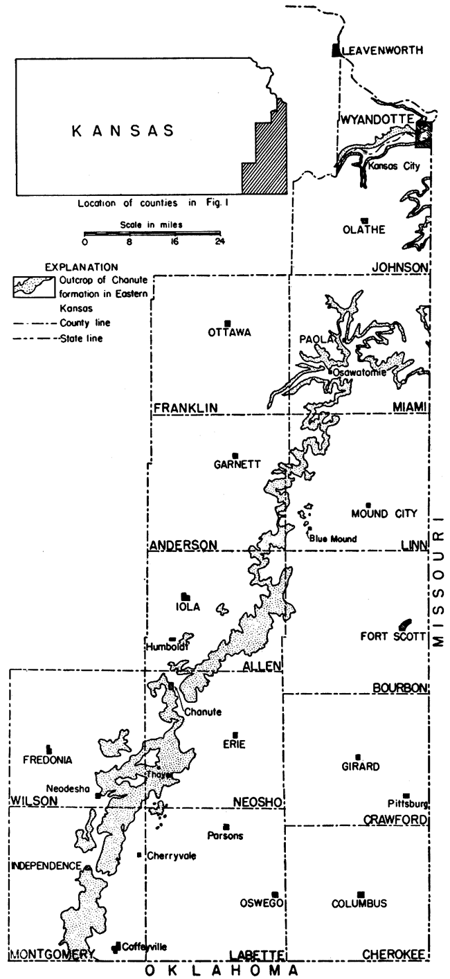
The Thayer coal occurs in the Chanute shale formation of the Kansas City group, Missourian series, Pennsylvanian subsystem. The Chanute formation (Moore, 1936, pp. 107-111) includes all strata above the Drum and below the Iola limestones and its outcrop extends southwestward as a narrow band from Kansas City in Wyandotte County across eastern Kansas to the Oklahoma state line in Montgomery County (fig. 1). The Thayer coal divides the Chanute shale into two parts. The Cottage Grove sandstone member, above, is predominantly tan to buff sandstone or arenaceous shale, whereas the lower member is mainly a gray and green argillaceous shale which in the southern counties contains much arenaceous shale and sandstone. The Chanute shale ranges in thickness from 6 feet near Kansas City to 160 feet in southern Montgomery County. The only fossils known from the formation are various types of plants associated with small pectanoid pelecypods found close to the coal and a few gastropods belonging to the species Worthenia tabulata found by Newell in a 1-foot bed of gray arenaceous shale overlying the Thayer coal south of the cen. sec. 32, T. 16 S., R. 23 E. (loc. 8). Among the plant fossils are fern leaves and calamites. The largest calamite seen measures approximately 34 by 28 by 8 inches and occurs at the head of a draw in the NE sec. 9, T. 28 S., R. 18 E., Neosho County (loc. 97).
Figure 1--Map of eastern Kansas showing outcrop area of the Chanute shale formation.
In the northern part of the area (Wyandotte, Johnson, and Miami counties) the upper member of the Chanute shale formation is seemingly absent. Here the formation consists essentially of gray argillaceous shale, olivine green in the lower few feet. A maroon argillaceous shale that ranges from 1 to 5 feet in thickness occurs locally near the base of the member. A maximum thickness of 15 feet of maroon shale was observed in a road cut in the SE sec. 4, T. 14 S., R. 25 E., Johnson County (loc. 2), but this zone was not found in the southern part of the state. A zone, 1 to 2 feet thick, called "marlite" by Newell (Newell and Jewett, 1935, p. 50) and described by him as "thin layers of yellowish-brown or greenish, nodular, and 'spongy' rock that ranges from a ferruginous, argillaceous limestone to a calcareous shale," occurs in the lower member immediately above the maroon shale wherever this shale is present. At other places, especially in the southern counties, the "marlite" is replaced by a zone of hard dense calcareous concretions, many of which are of the septarian type. Locally the lower shale member is arenaceous and contains sandstone beds in Neosho and Montgomery counties. The thickness of the lower shale member varies greatly not only in any one county but also from Wyandotte County in the north to Montgomery County in the south (table 1). It is possible that the lower shale member is entirely absent in secs. 1 and 23, T. 35 S., R. 15 E., Montgomery County, and in secs. 23 and 25, T. 27 S., R. 18 E., Neosho County. At these localities the entire formation is essentially sandstone and sandy shale, and no coal occurs. The formation is capped by the Iola limestone and rests directly on parts of the Cherryvale shale and the Dennis limestone.
Table 1--Range in thickness of the Chanute shale formation by members in eastern Kansas (in feet).
| County | Lower member |
Thayer coal |
Cottage Grove |
Total |
|---|---|---|---|---|
| Wyandotte | 6-15 | Streak | 0 | 6-15 |
| Johnson | 19-27 | Streak-0.1 | 0-15 | 19-34 |
| Miami | 11.3-18.2 | Streak-0.7 | 0-30 | 9-38.2 |
| Linn | 5.4-26.5+ | 0.2-1.0 | 5-27 | 15.5-40.2 |
| Allen | 6.5-12 | 0.3-0.5 | 7-18 | 18.5-19 |
| Neosho | 0-26 | 0.2-1.8 | 6-65 | 11.5-65 |
| Wilson | 11.4-32 | 0.5-1.8 | 1.5-70+ | 19.4-70 |
| Montgomery | 0-88+ | 0.3-2.4 | 30-160 | 74-160 |
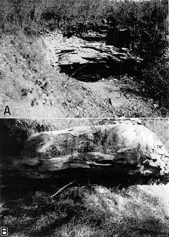
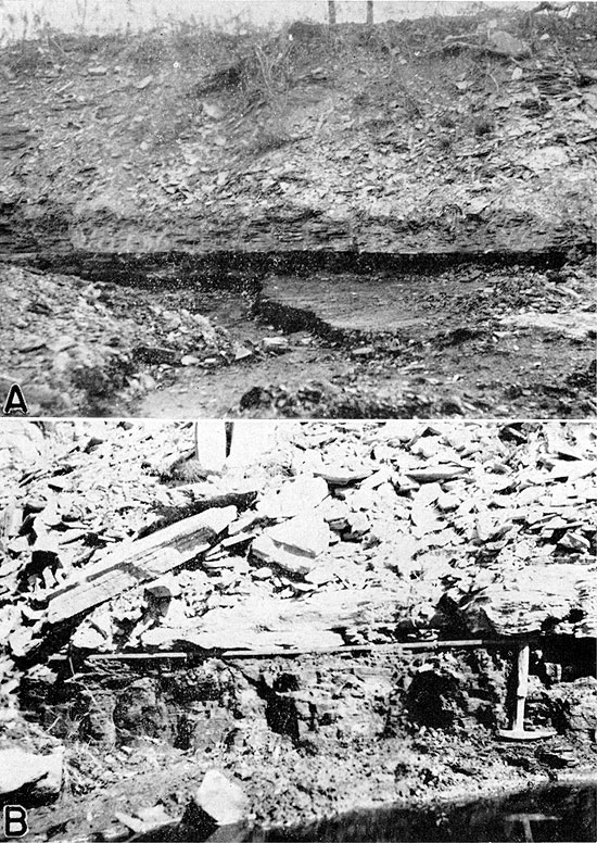
South of Miami County, the Chanute formation is almost everywhere divisible into two members. The upper member, named the Cottage Grove sandstone by Newell (Moore, 1936, p. 111) from Cottage Grove township in the southern part of Allen County, consists essentially of yellowish-brown, buff, tan, and reddish sandstone and sandy shales which increase in thickness from north to south. The member increases in thickness from 15 feet in southern Johnson County to 160 feet in southern Montgomery County (table 1). The sandstone is platy, thin, and even-bedded at many places (pl. 1A), but it is characterized by massive beds in Wilson and Montgomery counties (pl. 1B). Ripple marks and cross bedding are common features of the sandstones. Shale is more common in the Cottage Grove sandstone member from Linn County northward than in the counties to the south, although shale occurs in this sandstone at several localities south of Linn County, notably south of Independence in sec. 6, T. 33 S., R. 16 E., Montgomery County (loc. 254), where 18 feet of gray argillaceous laminated shale overlies the Thayer coal. The sandstone and sandy shales are generally soft and friable. The heavy or more massively bedded sandstone in Wilson and Montgomery counties is somewhat more firmly cemented than the thin-bedded sandstone.
Plate 1--A, Thin-bedded character of the Cottage Grove sandstone and mine entry, SE. sec. 30, T. 33 S., R. 16 E. B, Massive-bedded character of the Cottage Grove sandstone underlying Thayer coal 12 inches thick, City park zoo, Independence, Kansas.
Locally from one to three thin coal beds, usually less than 3 inches in thickness, occur within the Cottage Grove sandstone. At places, however, as in the SE sec. 29, T. 23 S., R. 21 E., Allen County (loc. 80), the coal ranges from 3 to 5 inches in thickness. At locality 163 (NW cor. SW sec. 36, T. 29 S., R. 16 E., Wilson County) the coal in the Cottage Grove member ranges from 7 to 9 inches in thickness; in sec. 29, T. 29 S., R. 17 E., it is 9.5 inches thick and 32 feet above the Thayer coal. It is also 9.5 inches thick and 31.5 feet above the Thayer coal in the cen. SE sec. 29, T. 29 S., R. 17 E., Neosho County. At least three coal seams occur in the Cottage Grove sandstone about 40 feet above the Thayer coal in secs. 28 and 33, T. 29 S., R. 17 E., Wilson County. According to Whitla (1940, pp. 19, 53, 62), one of the coal beds in the Cottage Grove is 10 to 17 inches thick and has been mined in secs. 29 and 32, T. 29 S., R. 17 E.
The Thayer coal, described in detail later in this report, separates the Chanute formation into the two members described above. It varies in thickness and stratigraphic position within the formation.
The area underlain by Chanute shale is generally flat because the formation consists of easily eroded shale, sandy shale, and soft sandstone. Along the major stream valleys, tributary stream erosion has produced a mature topography; and locally the Cottage Grove sandstone forms picturesque cliffs along the river bluffs (pl. 3C).
The Thayer coal has been traced almost continuously along the strike of the Chanute formation from Wyandotte County to the Kansas-Oklahoma state line in Montgomery County (fig. 1). In Miami County from the NE cor. T. 17 S., R. 23 E. to the SW cor. T. 19 S., R. 22 E., Newell (Newell and Jewett, 1935, pp. 49, 50) reports that the Chanute formation is less than 15 feet thick and that the coal is absent. Because the coal is thin and readily becomes concealed in the road ditches by weathered debris, it is not always visible at the surface. The Thayer coal has been observed by me or is known to occur at many places, all of which are listed by counties in tables 11 to 16 at the end of this report, and shown on figures 2 to 7.
In Neosho, Wilson, and Montgomery counties, where the Chanute formation is thickest, opportunities to measure stratigraphic sections and to determine the position of the Thayer coal within the formation are less numerous than in Wyandotte, Johnson, Linn, and Miami counties. This is due chiefly to the fact that wherever the formation is thick, erosion in the low-dipping nonresistant shales and sandstones has developed a more or less flat topography in which the overlying Iola and underlying Drum limestones are separated by distances commonly measurable in miles. The available field data and unpublished stratigraphic sections measured by Newell and Jewett indicate that the stratigraphic position of the Thayer coal is not everywhere the same within the Chanute formation. Where the formation is less than 17 feet thick, the coal is close to the top. Elsewhere, it lies generally nearer the base, although at some places the coal is in the upper part of the formation and at other localities it is approximately in the middle (table 2). According to numerous measurements made where only the coal and one of the bounding limestones are present, the interval between the Thayer coal and the Iola limestone ranges from 2.5 inches to 65 feet, whereas the interval between the coal and the base of the formation is 1.5 to 88 feet.
Table 2--Stratigraphic position of the Thayer coal in the Chanute shale formation.
| County | Outcrop No. |
Location | Thickness of Chanute formation (feet) |
Position of the coal | ||
|---|---|---|---|---|---|---|
| Feet below Iola limestone |
Feet above Drum limestone |
Relative | ||||
| Wyandotte | 1 | 12-11-24 E | 12 | Directly | 12- | Upper |
| Johnson | 3 | 10-14-25 E | 31.7 | 4.7 | 27 | Upper |
| Miami | 10 | 9-17-23 E | 15.7 | Directly | 15.5 | Upper |
| Miami | 17 | 24-18-24 E | 16.3 | 4 | 12 | Upper |
| Linn | 32 | 35-19-22 E | 17.3 | 5 | 12 | Upper |
| Wilson | 188 | 29-29-17 E | 30.8 | 5 | 24 | Upper |
| Johnson | 2 | 4-14-25 E | 34 | 15 | 19 | Middle |
| Miami | 5 | 33-16-23 E | 33.4 | 15.2 | 18.2 | Middle |
| Miami | 8 | 32-16-23 E | 36.2 | 20 | 16 | Middle |
| Linn | 35 | 16-20-22 E | 29.5 | 16 | 13 | Middle |
| Miami | 11 | 24-17-23 E | 33.8 | 23.5 | 14 | Lower |
| Miami | 13 | 31-17-24 E | 38.2 | 25 | 13 | Lower |
| Miami | 19 | 2-18-23 E | 33 | 21.2 | 11.5 | Lower |
| Miami | 22 | 25-18-22 E | 31.6 | 20 | 11.3 | Lower |
| Miami | 25 | 15-19-22 E | 36.5 | 25 | 11 | Lower |
| Linn | 26 | 21-19-22 E | 32.5 | 22 | 10 | Lower |
| Linn | 29 | 27-19-22 E | 40.6 | 24.4 | 16 | Lower |
| Linn | 31 | 21-19-22 E | 30+ | 17.5 | 12 | Lower |
| Linn | 33 | 32-19-22 E | 28 | 17 | 10.5 | Lower |
| Linn | 37 | 16-20-22 E | 34+ | 20 | 14 | Lower |
| Linn | 40 | 20-20-22 E | 34 | 21.3 | 12.5 | Lower |
| Linn | 42 | 31-20-22 E | 30+ | 19 | 10.5 | Lower |
| Linn | 43 | 7-21-22 E | 34 | 25.6 | 8 | Lower |
| Linn | 44 | 17-22-21 E | 37.5 | 25 | 12 | Lower |
| Linn | 46 | 25-21-21 E | 23 | 15 | 8 | Lower |
| Allen | 81 | 1-24-20 E | 20.3 | 13.5 | 6.5 | Lower |
| Montgomery | 252 | 30-32-16 E | 78.7 | 35 | 42.7 | Lower |
The Thayer coal ranges in thickness from a thin streak to 29 inches. It is thin in Wyandotte and Johnson counties and increases in thickness southward (table 3). The maximum thickness, 29 inches, was measured in Montgomery County at the abandoned brick-plant quarry south of Independence (cen. sec. 6, T. 33 S., R. 16 E.; loc. 254; pl. 2B).
Plate 2--A, Thayer coal, 11 inches thick, outcrop no. 223, SE sec. 23, T. 31 S., R. 16 E., 4.75 miles east of Sycamore, Montgomery County, Kansas. Overburden 15 feet. B, Outcrop of the Thayer coal, 29 inches thick, at the abandoned brick-plant quarry south of Independence, outcrop no. 254, Cen. E2 sec. 6, T. 33 S., R. 16 E., Montgomery County, Kansas. C, Thayer coal, 9 inches thick, outcrop no. 222, 0.2 mile west of the SE cor. sec. 24, T. 31 S., R. 16 E., Montgomery County, Kansas. Overburden 12 feet.
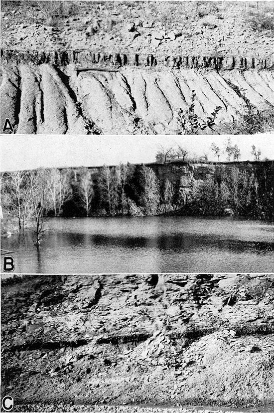
Table 3--Summary of thicknesses of the Thayer coal.
| County | Thickness range (inches) |
Average thickness (inches) |
|---|---|---|
| Wyandotte | Streak | Streak |
| Johnson | Streak-1 | 0.5 |
| Miami | Streak-8.5 | 2.5 |
| Linn | 2.5-12 | 6.5 |
| Anderson | 1-3 | 2 |
| Allen | 3.5-6 | 5 |
| Neosho | 2.5-20.5 | 8.1 |
| Wilson | 6-20.5 | 10.9 |
| Montgomery | 3.5-29 | 10.1 |
The coal does not always occur as a single bed. This is especially true where the coal is thickest. The shale parting that separates the coal is generally dark clay or black fissile shale. This is commonly 2 to 3 inches thick, but it attains a thickness of 5, 6, or 7 inches at some localities. At outcrop 163 in a creek bank (NW cor. SW sec. 36, T. 29 S., R. 17 E., Wilson County) it is 4 feet thick. At outcrops 97 in Neosho County, 153, 156, and 172 in Wilson County, and 254, 270, 277, and 289 in Montgomery County, the Thayer coal is made up of three beds. At outcrops 280 and 282 in Montgomery County the coal consists of four beds. There is no uniformity in the thicknesses of the individual coal beds where the Thayer is split by shale partings. The relationship of the number of coal beds, their thicknesses and relative positions, intervening shale partings, outcrops, and locality numbers are graphically presented in figure 8.
The Thayer coal is always overlain by sandstone or shale, generally even-bedded soft sandstone, argillaceous sandstone, or arenaceous shale of the Cottage Grove sandstone member of the Chanute formation (pl. 1A). Locally, massive friable soft sandstone occurs above the coal, as at locality 237 in the city park at Independence (pl. 1B). South of Independence at the abandoned brick-plant quarry, approximately in the cen. sec. 6, T. 33 S., R. 16 E. (loc. 254), the Thayer coal is overlain by laminated and argillaceous shale.
In most places the lower contact rock is gray to dark-gray argillaceous shale, although arenaceous shale is not uncommon. At outcrop 171 in the NE sec. 6, T. 30 S., R. 17 E., Wilson County, the lower contact shale is black and fissile. Although underclay has been reported to occur beneath the Thayer coal (Whitla, 1940, pp. 19, 51, 52, and 62), no typical underclay or "seat earth" was observed by me in the field. The contact shale exhibits distinct bedding and characteristics common to normal shales.
The Thayer coal is classified as a bituminous coal. As noted under "Thickness," one to three clay or shale partings separate the coal into two, three, or four distinct beds. Each separate coal bed, however, is commonly free from shale or silt. Where the shale parting is less than 1 inch thick, it is black and fissile and almost indistinguishable from the coal. The coal is bright, shiny, black, brittle, and moderately hard where it has been protected from weathering. The weathered coal displays a checkered or blocky appearance, is dull black to gray, and locally sooty in appearance. Even the weathered coal, however, tends to maintain its solidity, as crumbled fragments are nearly absent around the outcrops. Pyritized sandy woody material and pyrite concretions occur at some outcrops in the clay partings and immediately beneath the lowermost coal bed, but pyrite concretions have not been observed in the coal.
Samples of Thayer coal were collected at 13 localities. Sample number 8 is from the Dunbar strip mine, locality 202 (pls. 3A and 4; fig. 6) in the SW sec. 21, T. 29 S., R. 17 E., Wilson County; sample number 4 is from a drift mine near Thayer, locality 113 (fig. 6) in the NW sec. 31, T. 29 S., R. 18 E. All other samples were collected from natural exposures.. All samples are channel samples. It was impractical to collect samples from most of the abandoned mines, and at many places the coal is too thin to encourage the collection of samples from outcrops. Care was exercised not to get weathered material in the samples, but the necessity of sampling from outcrops prevented the complete elimination of all weathering effects in the samples collected.
Plate 3--A, Trench in the Dunbar strip coal mine, outcrop no. 202, SW cor. sec. 21, T. 29 S., R. 17 E., Wilson County, Kansas. Coal, 24 inches thick, lower dark band; basal limestone of the Iola formation upper dark band. B, Coal tipple at north end of the Dunbar strip coal mine. C, Massive bluffs of the Cottage Grove sandstone, NE sec. 16, T. 33 S., R. 16 E., Montgomery County, Kansas.
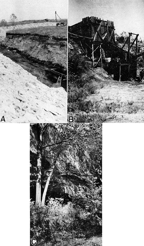
Plate 4--A, Thayer coal exposed after stripping, Dunbar strip coal mine, SW cor. sec. 21, T. 29 S., R. 17 E., Wilson County. B, Thayer coal, 24 inches thick, exposed by stripping; overburden 11 feet; Dunbar strip coal mine.
The analyses given in table 4 were made in the laboratories of the State Geological Survey of Kansas, by August Fleming, about a month after the samples had been collected. A comparison of the proximate analyses of the Thayer coal with those of other Kansas coals of commercial grade (table 5; Bowsher and Jewett, 1943, p. 57; Pierce and Courtier, 1937, p. 81; U.S. Bureau of Mines, 1929, pp. 32-37) shows that the quality of the Thayer coal is as high as the average of the coal now being mined in Kansas and that the Thayer coal is suitable for all purposes for which our present commercial coals are being used.
Table 4--Proximate analyses of the Thayer coal. (Analyses by August Fleming in the State Geological Survey laboratories).
| Outcrop No. |
County | Location | Moisture (percent) |
Volatile matter (percent) |
Fixed carbon (percent) |
Ash (percent) |
Sulphur (percent) |
B.T.U. per pound | |||
|---|---|---|---|---|---|---|---|---|---|---|---|
| As received |
Moisture free |
Moisture and ash free |
|||||||||
| 22 | Miami | 0.25 mi. N. of SW cor. | 25-18-22 E | 5.21 | 36.95 | 47.03 | 10.81 | 5.15 | 12,810 | 13,514 | 15,152 |
| 26 | Linn | NE cor. | 22-19-22 E | 5.20 | 36.36 | 34.90 | 23.54 | 1.32 | 10,828 | 11,422 | 14,939 |
| 63 | Linn | SE cor. of cemetery, NE cor. NW |
32-22-22 E | 2.40 | 35.49 | 52.49 | 9.62 | 0.69 | 13,325 | 13,653 | 15,102 |
| 113 | Neosho | SW NW | 31-29-18 E | 10.32 | 36.32 | 46.65 | 6.71 | 0.74 | 11,817 | 13,177 | 14,125 |
| 121 | Neosho | SE cor. NE | 1-30-17 E | 2.67 | 32.01 | 59.87 | 5.45 | 1.54 | 14,003 | 14,387 | 15,216 |
| 123 | Neosho | NW | 12-30-17 E | 4.83 | 31.68 | 52.93 | 10.53 | 0.62 | 12,814 | 13,464 | 15,048 |
| 163 | Wilson | NW cor. SW | 36-29-16 E | 3.78 | 35.80 | 52.30 | 8.12 | 1.34 | 13,479 | 14,009 | 15,316 |
| 202 | Wilson | SW | 21-29-17 E | 2.15 | 29.19 | 49.89 | 18.77 | 2.70 | 12,099 | 12,365 | 15,222 |
| 221 | Montgomery | 0.6 mi. E. of SW cor. | 18-31-17 E | 13.15 | 38.98 | 35.97 | 11.90 | 0.38 | 10,018 | 11,535 | 13,093 |
| 223 | Montgomery | 0.2 mi. W. of SE cor. | 23-31-16 E | 7.25 | 31.13 | 51.40 | 10.22 | 0.78 | 12,073 | 13,017 | 14,629 |
| 232 | Montgomery | 0.4 mi. N. and 100 yds. E. of SW cor. |
30-31-16 E | 1.82 | 35.96 | 48.16 | 14.06 | 0.85 | 13,397 | 13,587 | 15,810 |
| 252 | Montgomery | Independence water works plant |
19-32-16 E | 9.70 | 30.50 | 47.67 | 12.13 | 0.71 | 10,286 | 11,391 | 12,963 |
| 289 | Montgomery | 0.5 mi. E. and 0.15 mi. N. of SW cor. |
22-34-15 E | 3.50 | 34.52 | 54.31 | 7.67 | 6.00 | 14,062 | 14,572 | 15,783 |
Table 5--Average proximate analyses of Kansas coals.
| County | No. of analyses |
Name of coal |
Moisture (percent) |
Volatile matter (percent) |
Fixed carbon (percent) |
Ash (percent) |
Sulphur (percent) |
B.T.U. per pound | ||
|---|---|---|---|---|---|---|---|---|---|---|
| As received |
Moisture free |
Moisture and ash free |
||||||||
| Crawford | 3 | Fort Scott1 | 2.80 | 40.3 | 47.4 | 9.3 | 3.9 | 13,286 | 13,670 | 15,130 |
| Crawford and Labette |
6 | Bevier1 | 3.80 | 37.8 | 48.6 | 9.8 | 2.6 | 13,026 | 13,545 | 15,077 |
| Cherokee | 1 | Fleming1 | 2.80 | 39.3 | 47.3 | 10.6 | 2.3 | 13,090 | 13,470 | 15,120 |
| Cherokee and Crawford |
9 | Mineral1 | 4.30 | 34.3 | 48.7 | 12.6 | 3.8 | 12,488 | 13,048 | 15,029 |
| Barton (Mo.), Crawford, and Cherokee |
21 | Weir-Pittsburg1 | 6.10 | 33.3 | 50.7 | 9.9 | 3.7 | 12,622 | 13,367 | 15,007 |
| Cherokee | 3 | "Local"1 | 5.0 | 30.7 | 48.1 | 16.1 | 6.8 | 11,576 | 12,193 | 14,698 |
| Cherokee | 6 | Weir-Pittsburg2 | 5.05 | 33.98 | 52.33 | 8.63 | 3.8 | 13,045 | 13,738 | |
| Crawford | Weir-Pittsburg2 | 5.95 | 33.0 | 51.1 | 8.3 | 4.2 | 12,590 | 13,385 | 14,965 | |
| Leavenworth | 12 | Bevier2 | 11.85 | 35.35 | 39.9 | 12.9 | 4.1 | 11,145 | 12,335 | 14,433 |
| Linn | 11 | Mulberry2 | 9.26 | 31.66 | 45.44 | 13.43 | 2.94 | 11,386 | 12,552 | 14,733 |
| (1) From Pierce and Courtier (1937, p. 81). (2) Averages computed from U.S. Bureau of Mines analyses (1929, table 7). |
||||||||||
The types of mines and mining methods employed in the Thayer coal-mining districts of Linn, Montgomery, Neosho, and Wilson counties are the same as those of east-central Kansas (fig. 1). The reader interested in details of mining methods is referred to the extensive discussion on pages 17 to 26 in the report by Bowsher and Jewett on "Coal Resources of the Douglas Group in East-Central Kansas" published in 1943 by the State Geological Survey of Kansas as Bulletin 46. The Thayer coal is thin, and mining operations are small scale.
With few exceptions, all of the Thayer coal mines are drift or slope mines. These mines are tunnels dug in the coal bed at right angles to the line of outcrop or slope of the coal bank. Drift mines and slope mines are essentially the same, differing only in that the drift mine tunnel is driven into the hillside or stream bank horizontally whereas the slope mine tunnel is inclined. In all of the drift and slope mines seen by me, the tunnel mouth or entry is just large enough for a person to enter the mine either "on all fours" or in a crouched position (pl. 1A). As most of the mines are operated by one person, the entry is seldom more than 30 to 48 inches wide, although some openings 6 to 7 feet wide were observed. The coal is extracted by the miner in a recumbent position. Most of the mines are now abandoned and are full of water; entries are clogged with rocky debris and the roofs are more or less caved in.
Outcrop mines are those in which the coal is dug directly from the face of the outcrop without driving a tunnel into the stream bank or hillside. Such mines--if they properly may be called mines--are commonly in the beds of creeks or along their banks and extend parallel to the line of outcrop. Outcrop mines are few, of local extent, and yield only a small amount of coal.
The only important commercial coal mine operated in the Thayer coal during the fall of 1943 was the Dunbar strip mine (loc. 202) in the SE sec. 21, T. 29 S., R. 17 E., Wilson County (pl. 4A). The overburden consists of 9 to 12 feet of soft thin-bedded sandstone capped by one or two thin beds of limestone and some argillaceous shale and is removed by a small steam shovel having a capacity of 1.5 yards. The steam shovel was located in a pit or trench (pl. 3A), 50 feet wide, that extended in a general north-south direction parallel to the line of outcrop. In the northern part of the mined area some of the trenches trend east and west and others north and south. After the removal of the overburden (pl. 4A), the coal is pried loose and loaded into trucks by hand. A large amount of coal has been taken from this mine and much more is available.
A small amount of coal was mined by the stripping method at two places of limited extent in Montgomery County. At both places the overburden was no more than 3 or 4 feet thick and was removed by means of a team and scraper from areas 200 to 300 feet in diameter.
Four small shaft mines that have produced Thayer coal were visited. These shafts were located 300 feet or less from the coal outcrop. Two are located in the Blue Mound mining district of Linn County, one in Montgomery County, and one in Wilson County (table 6).
Table 6--Locations and dimensions of shaft mines.
| Locality No. |
County | Mining district |
Location | Shaft dimension (feet) |
|
|---|---|---|---|---|---|
| Width | Depth | ||||
| 55 | Linn | Blue Mound | SW cor. NE 29-22-22 E |
3+ | 18 |
| 59 | Linn | Blue Mound | NE cor. SW 29-22-22 E |
3+ | 8 |
| 239 | Montgomery | Chouteau-Irish Cr. | Cen. NW 36-31-16 E |
6 | 15-20 |
| 184 | Wilson | Chetopa Creek | SW cor 29-29-17 E |
6 × 15 | 10- |
Three of the shaft mines are well-like openings on the surface surrounded by dump piles of sandstone, shale, and coal. In each case the bottom of the shaft was concealed from view by water. One mine, located in the Blue Mound mining district of Linn County, in the NE cor. SW sec. 29, T. 22 S., R. 22 E. (loc. 59), has a shaft 8 to 9 feet deep covered by a small building containing the haulage-way which is 3 feet wide and 2.5 feet high. An old automobile engine was used for operating the hoist.
With few exceptions, Thayer coal mining has been of a noncommercial nature. Most of the mines were designed to be operated by one or two men, and the coal has generally been used as a winter fuel supply for the miner and his family. Local citizens report that during the early period of mining the landowner was paid a royalty of 1 to 1.5 cents for each 80-pound bushel of coal that was mined. In recent years, however, the standard practice (Glennon, 1937, p. 10) has been to pay the landowner 75 cents to 1 dollar per week for the privilege of mining coal on his property regardless of the amount of coal mined and the purpose for which it is to be used by the miner. Mining of Thayer coal has been almost entirely a secondary occupation carried on only during the winter months.
Statistics on the early production of Thayer coal are exceedingly fragmentary and incomplete. This incompleteness in the record is due largely to the fact that most of the mining was and still is of a noncommercial type. While it is not definitely known just when and where the Thayer coal was first mined, old residents report that the coal was mined as early as 1870 or about the same time that the mining districts were first settled. Official record of coal mining as early as 1875 in Montgomery, Neosho, and Wilson counties is contained in one of the early reports of the Kansas State Board of Agriculture (Gray, 1875, pp. 345, 355, 426). Lieutenant-Governor M. J. Salter is quoted (p. 355) as reporting that 62,500 tons of coal, selling for $3.50 per ton, were mined in sec. 6, T. 30 S., R. 18 E., Neosho County, in 1875. It is believed that the amount reported is in error because it is in no way comparable with production figures of other years. It is probable that the amount reported should have been in terms of bushels instead of tons, the bushel having been the accepted unit of measurement at that time. On this basis, Neosho County would have produced 2,500 tons of coal, an amount commensurate with production figures of other years. This coal was used primarily for domestic purposes, although a large amount (amount not stated) was shipped and used as fuel throughout the three counties mentioned above. Some of the Thayer coal, however, was hauled by the wagon load outside of the coal-producing counties. One former miner living several miles east and south of Neodesha in Wilson County stated that coal was hauled to Independence and Parsons, towns 17 and 25 miles distant respectively from the place where the coal was mined. Montgomery and Neosho counties produced respectively 2,000 and 8,000 tons of coal in 1880 (Hudson, 1881, pp. 245, 247). The following year Montgomery County had seven coal companies in operation and mined 1,182 tons of coal valued at $8,680 (Sims, 1883, p. 347). The Thayer coal district in 1887 is listed as having produced 750,000 bushels (30,000 tons) of coal (Findlay, 1888, p. 65). Production figures for later years show this to be entirely out of proportion, and it is my opinion that 3,000 tons or 75,000 bushels is more likely the amount of coal mined in Neosho County in 1887. According to published data, the annual output of Thayer coal in the Blue Mound district of Linn County amounted to 50 tons of coal in 1933 (Glennon, 1934, pp. 63, 88) and 150 tons in 1934 (Glennon, 1935, pp. 61, 79). Like the coal mining in Neosho, Wilson, and Montgomery counties, mining in the Blue Mound district of Linn County is essentially a noncommercial localized enterprise; therefore coal production statistics are not available.
The discovery of oil and gas and the resulting free or cheap gas to landowners brought about a sharp decline in the mining activities of the Thayer coal, a decline aided materially by increased shipments of Cherokee coal from the Pittsburg and surrounding coal districts. According to the annual reports of the Mine Inspection Division and Mine Rescue Station of the Labor Department, State of Kansas, the number of mines and the annual production of Thayer coal has sharply decreased in the last 10 years. The report of 1942 (Delplace, 1943, pp. 8, 46, 47) lists only one mine in operation in all the Thayer coal-mining districts. In 1942 Wilson County produced 1,378 tons of coal from one strip mine located in the SW sec. 21, T. 29 S., R. 17 E. (loc. 202).
The published data show a total of 157,088 tons of coal mined from the Thayer bed. For the reasons discussed above, this amount is undoubtedly far below the actual number of tons mined (table 7).
Table 7--Production of Thayer coal on the basis of published data (in tons).
| Year | Linn County |
Montgomery County |
Neosho County |
Wilson County |
Total |
|---|---|---|---|---|---|
| 1875 | 62,500? | 62,500? | |||
| 1880 | 2,000 | 8,000 | 10,000 | ||
| 1881 | 1,182 | 1,182 | |||
| 1885 | 7,660 | 7,660 | |||
| 1887 | 30,000? | 30,000? | |||
| 1921 | 3,700 | 3,700 | |||
| 1925 | 4,475 | 4,475 | |||
| 1926 | 4,541 | 4,541 | |||
| 1927 | 4,535 | 4,535 | |||
| 1931 | 2,792 | 2,792 | |||
| 1932 | 1,262 | 1,262 | |||
| 1933 | 50 | 1,224 | 844 | 2,118 | |
| 1934 | 150 | 996 | 215 | 1,361 | |
| 1935 | 1,000 | 1,500 | 2,500 | ||
| 1936 | 500 | 2,162 | 2,662 | ||
| 1937 | 480 | 2,750 | 3,230 | ||
| 1938 | 480 | 2,492 | 2,972 | ||
| 1939 | 450 | 2,543 | 2,993 | ||
| 1940 | 450 | 3,100 | 3,550 | ||
| 1941 | 1,677 | 1,677 | |||
| 1942 | 1,378 | 1,378 | |||
| Totals | 200 | 3,182 | 135,045 | 18,661 | 157,088 |
During the course of the field studies on the Thayer coal in Linn, Montgomery, Neosho, and Wilson counties, all available information concerning former mining activities was gathered from miners and residents. Many abandoned mines, drift openings, and outcrop workings were visited. The data gathered from these sources indicate that the production figures cited in table 7 are much too small for the total amount of coal mined. It is impossible to arrive at an accurate figure for the total production of Thayer coal but estimates have been made on the basis of field data. The Thayer coal-mining districts are well known and their limits defined. Maps included in this report show the location of the mines and the trace of the coal outcrop in each mining district. With five exceptions, all of the mines are drift mines which penetrate the coal banks from 75 to 200 yards and which average 100 yards in length. Mine entries are spaced at least 100 feet apart and in most places at much greater distances. Accordingly, the coal-mined area is a belt about 300 feet wide that parallels the line of coal outcrop. If it can be assumed on the basis of the type of mining employed and the spacing of mine entries that no more than 35 percent of the coal in the mined belt has been extracted, then the cumulative production of all Thayer coal, both commercial and noncommercial, to December 31, 1943, is 756,488 tons. The estimated cumulative production of the Thayer coal by mining districts is summarized in table 8.
The cumulative tonnage of the Thayer coal mined, as listed in table 8, is an estimate intended to show the magnitude of the coal produced. Relatively little of the Thayer coal has been mined; most of it remains as reserve.
Table 8--Estimated cumulative Thayer coal production by mining districts from 1869 to December 31, 1943.
| Mining district | County | Length of outcrop along which mines are located (feet) |
Average length of mine (feet) |
Area from which coal has been mined (sq. ft) |
Area of coal mined (sq. ft) |
Thickness of coal mined (inches) |
Area of coal mined (acres) |
Tons of coal per acre |
Estimated tons of coal mined |
|---|---|---|---|---|---|---|---|---|---|
| Blue Mound | Linn | 8,976 | 300 | 2,692,800 | 942,480 | 12 | 21.6 | 1,500 | 32,400 |
| Thayer-Coal Hollow | Neosho | 31,680 | 300 | 9,504,000 | 3,326,400 | 18 | 76.6 | 2,250 | 172,350 |
| Chetopa creek | Wilson | 44,880 | 300 | 13,464,000 | 4,712,400 | 18 | 108.1 | 2,250 | 243,225 |
| Dry creek-Washington branch | Wilson | 7,920 | 300 | 2,376,000 | 831,600 | 12 | 19.1 | 1,500 | 28,650 |
| Prior-Choteau | Montgomery | 5,280 | 300 | 1,584,000 | 554,400 | 12 | 12.7 | 1,500 | 19,050 |
| Sycamore | Montgomery | 7,260 | 300 | 2,178,000 | 762,300 | 7 | 17.5 | 875 | 15,313 |
| Independence, North | Montgomery | 5,280 | 300 | 1,584,000 | 554,400 | 18 | 42.4 | 2,250 | 95,400 |
| Independence,South | Montgomery | 3,960 | 300 | 1,188,000 | 415,800 | 18 | 29.7 | 2,250 | 66,825 |
| North Jefferson, Coal-Clear creeks |
Montgomery | 17,600 | 300 | 5,280,000 | 1,848,000 | 18 | 12.7 | 2,250 | 28,575 |
| East Jefferson | Montgomery | 9,900 | 300 | 2,970,000 | 1,039,500 | 12 | 23.8 | 1,500 | 35,700 |
| South Jefferson, Spring-Fawn creeks |
Montgomery | 12,320 | 300 | 3,696,000 | 1,293,600 | 16 | 9.5 | 2,000 | 19,000 |
| Totals | 756,488 |
Next Page--Reserves, Economics, Bibliography
Kansas Geological Survey, Geology
Placed on web April 23, 2009; originally published in July 1944.
Comments to webadmin@kgs.ku.edu
The URL for this page is http://www.kgs.ku.edu/Publications/Bulletins/52_3/index.html